Well, we still have ASCAT, which I suppose is better than nothing?brunota2003 wrote:I wish we still had QuikScat


Moderator: S2k Moderators


Well, we still have ASCAT, which I suppose is better than nothing?brunota2003 wrote:I wish we still had QuikScat


brunota2003 wrote:I'm still sticking with my Galveston to Brownsville area that I said last night. I feel confident the models will shift to the north and come into agreement somewhere around there. It is a huge area, but with the lack of picking a place by the models, along with uncertainty of what they will do will tons of new data for the 00Z runs, will just keep it as is.
-----
Personal Forecast Disclaimer:
The posts in this forum are NOT official forecast and should not be used as such. They are just the opinion of the poster and may or may not be backed by sound meteorological data. They are NOT endorsed by any professional institution or storm2k.org. For official information, please refer to the NHC and NWS products.
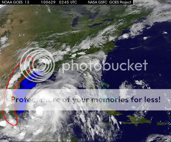
HouTXmetro wrote:CDO is really expanding or/and Alex is starting to book it NW now.
Dean4Storms wrote:timNms wrote:Dean4Storms wrote:This trough should head into eastern Canada or off the NE Seaboard, that is why the front is expected to wash out north of the Gulf Coast.
Thanks, Dean4Storms. I think I've got a better grasp of it now.
Keep in mind as the front loses steam the Atlantic Ridge builds back into the Gulf and links with the Rockies ridge which is what is expected to turn Alex back westward.
HouTXmetro wrote:CDO is really expanding or/and Alex is starting to book it NW now.


Sanibel wrote:It's starting to get that look. I can imagine what we will see tomorrow.
ConvergenceZone wrote:thetruesms, is that actually a picture of you in your Avatar? or is that from a movie? Just curious, as I feel like I've seen that character somewhere before.


Nederlander wrote:ConvergenceZone wrote:thetruesms, is that actually a picture of you in your Avatar? or is that from a movie? Just curious, as I feel like I've seen that character somewhere before.
TWISTER

tailgater wrote::uarrow: Can't tell direction from IR loops.
I'm a little surprised that no TS warnings are up for the NW Yucatan coast.


PortOConnorLurker wrote:With the shift in Alex's movement North, I would hope that the models would update to show the possible tracks shifting as well. Most people and employers down here on the coast rely on NHC forecasts for making their plans. Most of the people I have talked to today in the area are almost ignoring the fact that there is still a chance for a major impact on the central Texas Gulf Coast. With a model/forecast shift, then maybe everyone will get their act together and finish the prep-work needed around here.
I just want to thank everyone on here for all the up to date info. I have been reading this board for several years and have learned a lot.
I do wish that I could find that hat, however! By the time I got there, OU had done a pretty complete job of purging the old logo though.ConvergenceZone wrote:Nederlander wrote:ConvergenceZone wrote:thetruesms, is that actually a picture of you in your Avatar? or is that from a movie? Just curious, as I feel like I've seen that character somewhere before.
TWISTER
ahhh okay, that's right! That's where I've seen hiim...That's Dusty from Twister
Geez, I should have known that, Twister is my favorite movie of all time.............. I honestly thought that was a picture of thetruesms though. I just thought his face rung a bell. Now I know.
Thanks!
Users browsing this forum: No registered users and 55 guests