ATL: TROPICAL DEPRESSION ALEX - DISCUSSION

Moderator: S2k Moderators

Message
Author
User avatar
Texashawk
Category 2
Category 2
Posts: 579
Joined: Tue Aug 14, 2007 1:50 am
Location: Missouri City, TX (Houston)

Re: ATL: HURRICANE ALEX - DISCUSSION

#3981 Postby Texashawk » Wed Jun 30, 2010 4:05 am

000
WTNT41 KNHC 300851
TCDAT1
HURRICANE ALEX DISCUSSION NUMBER 19
NWS TPC/NATIONAL HURRICANE CENTER MIAMI FL AL012010
400 AM CDT WED JUN 30 2010

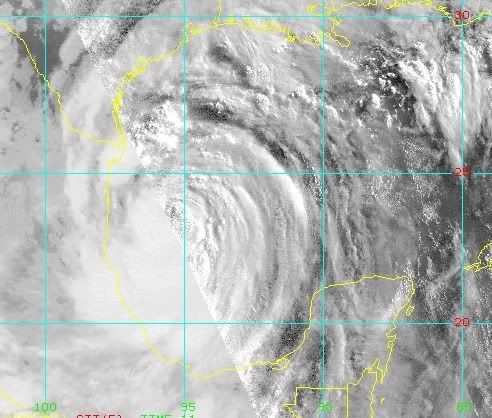
ALEX HAS BECOME MUCH BETTER ORGANIZED THIS MORNING BASED ON
WELL-DEFINED BANDING FEATURES WRAPPING INTO THE CENTER AND THE
APPEARANCE OF A SMALL EYE IN INFRARED IMAGERY. AN AIR FORCE RESERVE
UNIT RECONNAISSANCE AIRCRAFT AT 0842Z MEASURED A CENTRAL PRESSURE
961 MB AND 850 MB FLIGHT-LEVEL WINDS OF 82 KT IN THE NORTHEAST
QUADRANT. THE SFMR ABOARD THE PLANE MEASURED A RELIABLE SURFACE
WIND OF 62 KT AND A RAIN-CONTAMINATED PEAK WIND OF 71 KT. THE
DVORAK INTENSITY ESTIMATE FROM BOTH TAFB AND SAB WAS T4.5/77 KT.
THEREFORE...THE INITIAL INTENSITY IS CONSERVATIVELY INCREASED TO 70
KT FOR THIS ADVISORY.

ALEX HAS WOBBLED WEST-NORTHWESTWARD OVER THE PAST 6 HOURS...AND EVEN
BRIEFLY STALLED. HOWEVER...TRENDING THROUGH THE SATELLITE AND RECON
FIXES YIELDS AN AVERAGE MOTION OF 290/06. UPPER-AIR OBSERVATIONS AT
00Z INDICATED MODEST 10-30 METER HEIGHT RISES FROM 700-400 MB
ACROSS THE GULF COAST FROM LOUISIANA TO FLORIDA...BUT ALSO TO THE
NORTHWEST AND WEST OF ALEX ACROSS TEXAS MEXICO TO THE WEST. THIS
MEANS ALEX IS EMBEDDED BETWEEN TO RIDGES AND IN A WEAKER STEERING
FLOW REGIME THAT NONE OF THE MODELS PICKED UP ON IN THE SHORT TERM.

HOWEVER...ALL OF THE GLOBAL AND REGIONAL MODELS ARE CONSISTENT ON
BRINGING A MID-LEVEL RIDGE FROM WESTERN NEBRASKA SOUTHEASTWARD TO
THE TENNESSEE VALLEY DURING THE NEXT 48 HOURS...WHICH SHOULD ACT TO
STEER ALEX ON WEST-NORTHWESTWARD TRACK FOR THE NEXT 24 HOURS AND
THEN WESTWARD ACROSS NORTHERN MEXICO AFTER THAT. THERE HAS BEEN AN
INTERESTING CHANGE IN THE 00Z AND 06 MODEL GUIDANCE WITH THE ECMWF
SHIFTING FARTHER NORTHWARD...WHICH MEANS THIS MDOEL HAS GONE FROM
BEING THE PERSISTENT LEFT-MOST OF THE MODELS TO THE RIGHT SIDE OF
THE MODEL SUITE...AND IT NOW HAS A TRACK SIMILAR TO HWRF. THE
OFFICIAL FORECAST TRACK HAS BEEN SHIFTED SLIGHTLY TO THE RIGHT OF
THE PREVIOUS TRACK BASED ON THE MORE NORTHWARD INITIAL POSITION...
AND REMAINS NEAR THE EXTREME RIGHT SIDE OF THE GUIDANCE ENVELOPE
AND NORTH OF THE MODEL CONSENSUS.

VERTICAL SHEAR IS FORECAST TO REMAIN LIGHT UP UNTIL LANDFALL OCCURS
IN ABOUT 24 HOURS. GIVEN THAT ALEX IS ALSO MOVING SLOWLY OVER SOME
OF THE WARMEST UPPER-OCEAN HEAT CONTENT IN THAT REGION OF THE GULF
OF MEXICO...STEADY STRENGTHENING RIGHT UP UNTIL LANDFALL SEEMS
REASONABLE. HOWEVER...GIVEN THE RELATIVELY LOW CENTRAL PRESSURE
RECENTLY MEASURED BY THE RECON AIRCRAFT...RAPID INTENSIFICATION OF
AT LEAST 30 KT IN 24 HOURS IS A DISTINCT POSSIBILITY. THE OFFICIAL
INTENSITY FORECAST IS A BLEND OF THE LGEM AND SHIPS MODELS.

FORECAST POSITIONS AND MAX WINDS

INITIAL 30/0900Z 23.3N 95.1W 70 KT
12HR VT 30/1800Z 23.8N 96.2W 80 KT
24HR VT 01/0600Z 24.3N 97.7W 85 KT
36HR VT 01/1800Z 24.5N 99.6W 35 KT...INLAND
48HR VT 02/0600Z 24.4N 101.7W 20 KT...DISSIPATING INLAND
72HR VT 03/0600Z...DISSIPATED INLAND

$$
FORECASTER STEWART


Some interesting things Stacy has to say about the models being thrown a left curve at this late date... just saying...
Last edited by Texashawk on Wed Jun 30, 2010 4:06 am, edited 1 time in total.
0 likes   

Aric Dunn
Category 5
Category 5
Posts: 21238
Age: 42
Joined: Sun Sep 19, 2004 9:58 pm
Location: Ready for the Chase.
Contact:

#3982 Postby Aric Dunn » Wed Jun 30, 2010 4:06 am

that was one of the best discussions in a while.. stewart is the best...
0 likes   

User avatar
neospaceblue
Tropical Storm
Tropical Storm
Posts: 112
Age: 32
Joined: Fri Aug 10, 2007 3:17 pm
Location: Newport News, VA

Re: Re:

#3983 Postby neospaceblue » Wed Jun 30, 2010 4:06 am

Cyclenall wrote:
T-man wrote:084230 2320N 09458W 8439 01131 9594 +213 +196 117012 017 000 005 03


That's some low pressure. 959.4

Image

:eek: That is NUTS! This is still June and we are reaching sub 960 mb values! How much farther until it reaches the lowest June TC Atlantic record? :double:


Just 13 mbars to go before it beats Audrey.
0 likes   

User avatar
somethingfunny
ChatStaff
ChatStaff
Posts: 3926
Age: 37
Joined: Thu May 31, 2007 10:30 pm
Location: McKinney, Texas

Re: ATL: HURRICANE ALEX - DISCUSSION

#3984 Postby somethingfunny » Wed Jun 30, 2010 4:10 am

I'm not quite sure what to make of this thing but I think it's about time for me to replace "thing" with "monster". Cat 1 winds, Cat 3 pressure...what about the surge? And of course it's still got plenty of time to strengthen further.

It reminds me more than a little bit of Ike, and as someone else said, Opal. Some folks in Deep South Texas (not out of the woods yet) and Northeast Mexico may be expecting another Dolly and they may not understand that this is a WHOLE different animal!
0 likes   

User avatar
TexasF6
S2K Supporter
S2K Supporter
Posts: 816
Joined: Mon Aug 09, 2004 9:33 pm
Location: Austin, TX

Re: ATL: HURRICANE ALEX - DISCUSSION

#3985 Postby TexasF6 » Wed Jun 30, 2010 4:13 am

Fascinating. Get your popcorn ready....or donuts....if he explodes rapidly, Cat 2 perhaps at landfall, 100-105mph...especially if he stair-steps again....Will his steady gain in strength increase his poleward instinct I wonder? Or will he behave with the model forecasting? :double:

These statements are not endorsed by the NHC, nor by starfleet. Thank You. :flag:
0 likes   

Time_Zone
Category 1
Category 1
Posts: 251
Joined: Sat May 08, 2010 4:15 am

#3986 Postby Time_Zone » Wed Jun 30, 2010 4:18 am

This 'monster'...has around 24 hours left before landfall?!?!?! Oh man....lets hope he picks up speed because thats alot of time for a system going through RI.

I can't believe it's only June! I can only imagine what kind of storms are going to develop in two/three months time. :eek:
0 likes   

User avatar
KWT
Category 5
Category 5
Posts: 31415
Joined: Tue Aug 17, 2004 11:02 am
Location: UK!!!

#3987 Postby KWT » Wed Jun 30, 2010 5:04 am

Its got an insane pressure-wind relationship, you'd have to think at some point soon the winds will race up to catch up the pressure, because even if you use a WPAC conversion 959mbs is still rather low for a 70kts hurricane!

Also very interesting that its slowed right down, there was a chance of this and some models hinted at it a few days ago, though the stall on Monday means its doing it offshore rather then inland...
0 likes   
Personal Forecast Disclaimer:
The posts in this forum are NOT official forecast and should not be used as such. They are just the opinion of the poster and may or may not be backed by sound meteorological data. They are NOT endorsed by any professional institution or storm2k.org. For official information, please refer to the NHC and NWS products

User avatar
Portastorm
Storm2k Moderator
Storm2k Moderator
Posts: 9914
Age: 63
Joined: Fri Jul 11, 2003 9:16 am
Location: Round Rock, TX
Contact:

Re: ATL: HURRICANE ALEX - DISCUSSION

#3988 Postby Portastorm » Wed Jun 30, 2010 5:27 am

Morning friends ... just want to make sure my caffeine-starved eyes aren't seeing things ... Alex is moving to the right of his projected points by NHC, correct? Hmm ...
0 likes   

User avatar
mpic
S2K Supporter
S2K Supporter
Posts: 622
Joined: Thu Oct 20, 2005 11:24 am
Location: Splendora, TX

#3989 Postby mpic » Wed Jun 30, 2010 5:40 am

Post deleted
Last edited by mpic on Wed Jun 30, 2010 6:19 am, edited 1 time in total.
0 likes   
Alicia, Rita, Ike, Harvey and Beryl...moved to Splendora lol

User avatar
KWT
Category 5
Category 5
Posts: 31415
Joined: Tue Aug 17, 2004 11:02 am
Location: UK!!!

#3990 Postby KWT » Wed Jun 30, 2010 6:05 am

Alex moving WNW but very slowly right now, recon shows pressure down to 958.7mbs which is pretty insane really to have a system thaat low and only have 70kts winds...

Anyway if it carries on at this pace we will still have a while to go till landfall, esp if it decides to wobble NW at times.
0 likes   
Personal Forecast Disclaimer:
The posts in this forum are NOT official forecast and should not be used as such. They are just the opinion of the poster and may or may not be backed by sound meteorological data. They are NOT endorsed by any professional institution or storm2k.org. For official information, please refer to the NHC and NWS products

User avatar
cycloneye
Admin
Admin
Posts: 145366
Age: 68
Joined: Thu Oct 10, 2002 10:54 am
Location: San Juan, Puerto Rico

Re: ATL: HURRICANE ALEX - DISCUSSION

#3991 Postby cycloneye » Wed Jun 30, 2010 6:12 am

Look at that big band just east of Brownsville moving toards that city.

Image
0 likes   
Visit the Caribbean-Central America Weather Thread where you can find at first post web cams,radars
and observations from Caribbean basin members Click Here

User avatar
KWT
Category 5
Category 5
Posts: 31415
Joined: Tue Aug 17, 2004 11:02 am
Location: UK!!!

#3992 Postby KWT » Wed Jun 30, 2010 6:23 am

Some heavy rains moving into S.Texas now, the fact the system has really slowed down in its forward speed is not a good thing for the flooding risks.

I think 85-90kts is looking like a decent enough call for now despite the fact the system seems to have a very whacked pressure-wind relationship...

Some people are going to be surprised when they see where this system is at.
0 likes   
Personal Forecast Disclaimer:
The posts in this forum are NOT official forecast and should not be used as such. They are just the opinion of the poster and may or may not be backed by sound meteorological data. They are NOT endorsed by any professional institution or storm2k.org. For official information, please refer to the NHC and NWS products

User avatar
cperez1594
Tropical Depression
Tropical Depression
Posts: 67
Age: 38
Joined: Sun Dec 20, 2009 11:11 am
Location: Harlingen, TX

Re: ATL: HURRICANE ALEX - DISCUSSION

#3993 Postby cperez1594 » Wed Jun 30, 2010 6:30 am

Well we are getting some good rain bands right now here in south texas. We are awaiting for the rest to come. What do you mean we will be surprise with the system or move? I am looking at Alex and for some reason it seems to be stalling and might be wobbling Northwest but might be my eyes. What do you all think?
0 likes   
HAM Radio Operator KF5HFA
Deep South Texas- Rio Grande Valley

User avatar
KWT
Category 5
Category 5
Posts: 31415
Joined: Tue Aug 17, 2004 11:02 am
Location: UK!!!

#3994 Postby KWT » Wed Jun 30, 2010 6:34 am

Surprised by firstly the pressure being below 960mbs, thats exceptionally rare for a June system (about as rare as a peak time system going sub 895mbs) and the fact its slowed right down, considering some were thinking it could be nearly onland by now last night.
0 likes   
Personal Forecast Disclaimer:
The posts in this forum are NOT official forecast and should not be used as such. They are just the opinion of the poster and may or may not be backed by sound meteorological data. They are NOT endorsed by any professional institution or storm2k.org. For official information, please refer to the NHC and NWS products

User avatar
cycloneye
Admin
Admin
Posts: 145366
Age: 68
Joined: Thu Oct 10, 2002 10:54 am
Location: San Juan, Puerto Rico

Re: ATL: HURRICANE ALEX - DISCUSSION

#3995 Postby cycloneye » Wed Jun 30, 2010 6:46 am

I highlighted what AVILA says about the movement.

BULLETIN
HURRICANE ALEX INTERMEDIATE ADVISORY NUMBER 19A
NWS TPC/NATIONAL HURRICANE CENTER MIAMI FL AL012010
700 AM CDT WED JUN 30 2010

...ALEX MOVING IN NO HURRY......


SUMMARY OF 700 AM CDT...1200 UTC...INFORMATION
----------------------------------------------
LOCATION...23.4N 95.3W
ABOUT 155 MI...250 KM E OF LA PESCA MEXICO
ABOUT 220 MI...355 KM SE OF BROWNSVILLE TEXAS
MAXIMUM SUSTAINED WINDS...80 MPH...130 KM/HR
PRESENT MOVEMENT...WNW OR 290 DEGREES AT 7 MPH...11 KM/HR
MINIMUM CENTRAL PRESSURE...959 MB...28.32 INCHES
0 likes   
Visit the Caribbean-Central America Weather Thread where you can find at first post web cams,radars
and observations from Caribbean basin members Click Here

User avatar
Chacor
Category 5
Category 5
Posts: 10229
Joined: Mon Oct 02, 2006 10:43 pm
Location: Singapore

#3996 Postby Chacor » Wed Jun 30, 2010 6:46 am

959 hPa is incredibly low for a Cat 1 hurricane, and this would be true even in the Pacific where the wind-pressure relationship is different.
0 likes   

User avatar
alan1961
Category 2
Category 2
Posts: 771
Joined: Mon Mar 20, 2006 11:58 am
Location: Derby, Derbyshire, England
Contact:

Re: ATL: HURRICANE ALEX - DISCUSSION

#3997 Postby alan1961 » Wed Jun 30, 2010 6:48 am

haha..i take the hint kwt.. :lol: yes i was one of them
saying it would be landfalling in 12 hours...what is this
crazy storm going to do next...btw..alex's partial
centre is just coming into view on weatherTap radar if
your subscribed..can get a free trial for two weeks also :wink:
0 likes   

User avatar
latitude_20
Tropical Storm
Tropical Storm
Posts: 196
Joined: Wed Jun 30, 2010 6:46 am
Location: Tulum, Mexico
Contact:

Re: ATL: HURRICANE ALEX - DISCUSSION

#3998 Postby latitude_20 » Wed Jun 30, 2010 6:50 am

I'm 760 miles NW of Alex and we've had a a few rain bands move through overnight. Thing's huge.
0 likes   

User avatar
KWT
Category 5
Category 5
Posts: 31415
Joined: Tue Aug 17, 2004 11:02 am
Location: UK!!!

Re: ATL: HURRICANE ALEX - DISCUSSION

#3999 Postby KWT » Wed Jun 30, 2010 6:56 am

alan1961 wrote:haha..i take the hint kwt.. :lol: yes i was one of them
saying it would be landfalling in 12 hours...what is this
crazy storm going to do next...btw..alex's partial
centre is just coming into view on weatherTap radar if
your subscribed..can get a free trial for two weeks also :wink:


To be fair my 18-21hrs is looking too slow unless it hits in the next 6-9hrs, which at its current pace its not going to occur.
0 likes   
Personal Forecast Disclaimer:
The posts in this forum are NOT official forecast and should not be used as such. They are just the opinion of the poster and may or may not be backed by sound meteorological data. They are NOT endorsed by any professional institution or storm2k.org. For official information, please refer to the NHC and NWS products

User avatar
leaf blower
Tropical Low
Tropical Low
Posts: 39
Joined: Mon Jul 21, 2008 8:01 am

Re: ATL: HURRICANE ALEX - DISCUSSION

#4000 Postby leaf blower » Wed Jun 30, 2010 7:10 am

Image
0 likes   


Return to “2010”

Who is online

Users browsing this forum: No registered users and 5 guests