ATL: TROPICAL DEPRESSION ALEX - DISCUSSION
Moderator: S2k Moderators

Looking pretty decent there, should get a proper good look of the core soon enough after the Vis.imagery gets updated in about half an hour.
0 likes
Personal Forecast Disclaimer:
The posts in this forum are NOT official forecast and should not be used as such. They are just the opinion of the poster and may or may not be backed by sound meteorological data. They are NOT endorsed by any professional institution or storm2k.org. For official information, please refer to the NHC and NWS products
The posts in this forum are NOT official forecast and should not be used as such. They are just the opinion of the poster and may or may not be backed by sound meteorological data. They are NOT endorsed by any professional institution or storm2k.org. For official information, please refer to the NHC and NWS products
-
jasons2k

- Storm2k Executive

- Posts: 8290
- Age: 52
- Joined: Wed Jul 06, 2005 12:32 pm
- Location: The Woodlands, TX
Re: ATL: HURRICANE ALEX - DISCUSSION
On radar, Alex has moved to the right of the NHC track. In fact, movement since the 4AM position has been almost due NW:

0 likes
-
brunota2003

- S2K Supporter

- Posts: 9476
- Age: 35
- Joined: Sat Jul 30, 2005 9:56 pm
- Location: Stanton, KY...formerly Havelock, NC
- Contact:

Yep Jasons I think your right it is moving more to the NW...
Recon also seems to confirm the movement is more to the NW recently, pressure down to 957.1mbs!
Recon also seems to confirm the movement is more to the NW recently, pressure down to 957.1mbs!
0 likes
Personal Forecast Disclaimer:
The posts in this forum are NOT official forecast and should not be used as such. They are just the opinion of the poster and may or may not be backed by sound meteorological data. They are NOT endorsed by any professional institution or storm2k.org. For official information, please refer to the NHC and NWS products
The posts in this forum are NOT official forecast and should not be used as such. They are just the opinion of the poster and may or may not be backed by sound meteorological data. They are NOT endorsed by any professional institution or storm2k.org. For official information, please refer to the NHC and NWS products


Re: ATL: HURRICANE ALEX - DISCUSSION
This thing is huge! I think that the cloud field is even larger than that of Ike, and the media is not giving much attention to it, at least the channels that I have.
0 likes
Still no signs of any strengthening according to the winds, still only getting 85-87kts at FL in the NE quadrant.
So still at 70kts, now with a pressure of 957mbs...what a freaky hurricane this is!
So still at 70kts, now with a pressure of 957mbs...what a freaky hurricane this is!
0 likes
Personal Forecast Disclaimer:
The posts in this forum are NOT official forecast and should not be used as such. They are just the opinion of the poster and may or may not be backed by sound meteorological data. They are NOT endorsed by any professional institution or storm2k.org. For official information, please refer to the NHC and NWS products
The posts in this forum are NOT official forecast and should not be used as such. They are just the opinion of the poster and may or may not be backed by sound meteorological data. They are NOT endorsed by any professional institution or storm2k.org. For official information, please refer to the NHC and NWS products
-
brunota2003
- S2K Supporter
- Posts: 9476
- Age: 35
- Joined: Sat Jul 30, 2005 9:56 pm
- Location: Stanton, KY...formerly Havelock, NC
- Contact:
Well we had something similar in the biggies of 2005 but not to the same extent as this. Wilma got down to 970mbs as a 70kts system...The only one that is close is Ike after Cuba where it was down to 959mbs at 75kts....but this one obviously beats both!
Alex is one heck of a first Named Storm of the 2010 season...flooding going to be a big issue for N.Mexico and S.Texas.
Alex is one heck of a first Named Storm of the 2010 season...flooding going to be a big issue for N.Mexico and S.Texas.
0 likes
Personal Forecast Disclaimer:
The posts in this forum are NOT official forecast and should not be used as such. They are just the opinion of the poster and may or may not be backed by sound meteorological data. They are NOT endorsed by any professional institution or storm2k.org. For official information, please refer to the NHC and NWS products
The posts in this forum are NOT official forecast and should not be used as such. They are just the opinion of the poster and may or may not be backed by sound meteorological data. They are NOT endorsed by any professional institution or storm2k.org. For official information, please refer to the NHC and NWS products
-
Air Force Met
- Military Met

- Posts: 4372
- Age: 57
- Joined: Tue Jul 08, 2003 9:30 am
- Location: Roan Mountain, TN
Re: ATL: HURRICANE ALEX - DISCUSSION
Here is the 00z 500 mb from last night that I hand analyzed every 10mb. It explains the current slow movement and the recent NNW motion. There is the break that Stewart mentioned in the 4am discussion.
Deltadog and I were looking at this trof coming down a couple of nights ago and wondering what impact it would have on the track. We were at a loss since none of the models showed it having an influence...yet it was there breaking down the ridge in NE TX. We felt it had to move north some in response...but at the same time the models had to be seeing something to be in such good agreement.
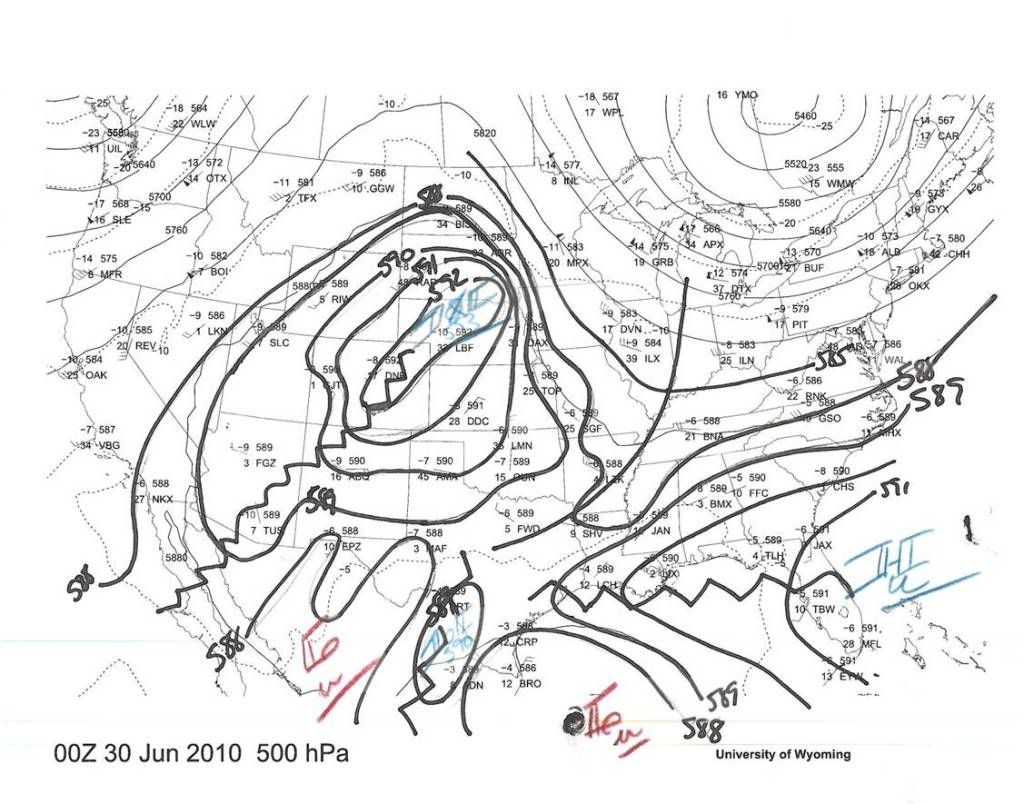
Deltadog and I were looking at this trof coming down a couple of nights ago and wondering what impact it would have on the track. We were at a loss since none of the models showed it having an influence...yet it was there breaking down the ridge in NE TX. We felt it had to move north some in response...but at the same time the models had to be seeing something to be in such good agreement.
0 likes

-
brunota2003
- S2K Supporter
- Posts: 9476
- Age: 35
- Joined: Sat Jul 30, 2005 9:56 pm
- Location: Stanton, KY...formerly Havelock, NC
- Contact:
Alex has a big double wind Maxima at least on the NE side, upto 84kts WAY out from the eyewall...
Theres your reason why this system is still only at 70kts, its pretty much got the same internal structure as Ike from the looks of things.
Theres your reason why this system is still only at 70kts, its pretty much got the same internal structure as Ike from the looks of things.
0 likes
Personal Forecast Disclaimer:
The posts in this forum are NOT official forecast and should not be used as such. They are just the opinion of the poster and may or may not be backed by sound meteorological data. They are NOT endorsed by any professional institution or storm2k.org. For official information, please refer to the NHC and NWS products
The posts in this forum are NOT official forecast and should not be used as such. They are just the opinion of the poster and may or may not be backed by sound meteorological data. They are NOT endorsed by any professional institution or storm2k.org. For official information, please refer to the NHC and NWS products
-
TeamPlayersBlue

- Category 5

- Posts: 3531
- Joined: Tue Feb 02, 2010 1:44 am
- Location: Denver/Applewood, CO
The NE Quadrant is very strong. Wow.
0 likes
Personal Forecast Disclaimer:
The posts in this forum are NOT official forecast and should not be used as such. They are just the opinion of the poster and may or may not be backed by sound meteorological data. They are NOT endorsed by any professional institution or storm2k.org. For official information, please refer to the NHC and NWS products.
The posts in this forum are NOT official forecast and should not be used as such. They are just the opinion of the poster and may or may not be backed by sound meteorological data. They are NOT endorsed by any professional institution or storm2k.org. For official information, please refer to the NHC and NWS products.
Yeah there are some decent winds well out from the center, which should mean hurricane winds will extend a decent way out I'd imagine because of that double wind Maxima.
0 likes
Personal Forecast Disclaimer:
The posts in this forum are NOT official forecast and should not be used as such. They are just the opinion of the poster and may or may not be backed by sound meteorological data. They are NOT endorsed by any professional institution or storm2k.org. For official information, please refer to the NHC and NWS products
The posts in this forum are NOT official forecast and should not be used as such. They are just the opinion of the poster and may or may not be backed by sound meteorological data. They are NOT endorsed by any professional institution or storm2k.org. For official information, please refer to the NHC and NWS products
-
HURAKAN

- Professional-Met

- Posts: 46084
- Age: 39
- Joined: Thu May 20, 2004 4:34 pm
- Location: Key West, FL
- Contact:
Re: ATL: HURRICANE ALEX - DISCUSSION
12z
AL, 01, 2010063012, , BEST, 0, 235N, 952W, 70, 958, HU
AL, 01, 2010063012, , BEST, 0, 235N, 952W, 70, 958, HU
0 likes
Who is online
Users browsing this forum: No registered users and 27 guests