ATL: TROPICAL DEPRESSION ALEX - DISCUSSION

Moderator: S2k Moderators

Message
Author
Air Force Met
Military Met
Military Met
Posts: 4372
Age: 56
Joined: Tue Jul 08, 2003 9:30 am
Location: Roan Mountain, TN

Re:

#4021 Postby Air Force Met » Wed Jun 30, 2010 7:52 am

brunota2003 wrote:How much of an impact will that trof have on Alex's movement, do you think? Since any slight wobble could easily move the landfall point a good distance.


That is really hard to say. Looking at the BRO radar...it looks like he is moving at about 350 for the last hour. There is so much debris in the water vapor field...I can't see the short wave...but Alex' cloud pattern is elongated to the N-S...which means the short term motion should be that way.


I can't imagine it would go north too much longer. That would be an epic bust by all models...
0 likes   

User avatar
KWT
Category 5
Category 5
Posts: 31415
Joined: Tue Aug 17, 2004 11:02 am
Location: UK!!!

#4022 Postby KWT » Wed Jun 30, 2010 7:58 am

AFM, yeah recon confirms a track of probably about 335 between its 2nd and 3rd pass through, so it does seem like its jogged to the north-west/NNW.

Didn't Dolly move more to the NW then was expected at one point?
0 likes   
Personal Forecast Disclaimer:
The posts in this forum are NOT official forecast and should not be used as such. They are just the opinion of the poster and may or may not be backed by sound meteorological data. They are NOT endorsed by any professional institution or storm2k.org. For official information, please refer to the NHC and NWS products

PauleinHouston
Tropical Storm
Tropical Storm
Posts: 102
Joined: Mon Aug 13, 2007 10:23 am
Location: League City, TX
Contact:

Re: ATL: HURRICANE ALEX - DISCUSSION

#4023 Postby PauleinHouston » Wed Jun 30, 2010 8:00 am

Brownsville long range radar loop...

http://radar.weather.gov/radar.php?product=N0Z&rid=BRO&loop=yes

Definitely a N/NW movement at this point
0 likes   
The posts in this forum are NOT official forecasts and should not be used as such. They are just the opinion of this amateur poster and may or may not be backed by sound meteorological data. They are NOT endorsed by any professional institution or storm2k.org. For official information, please refer to NWS products.

User avatar
tailgater
S2K Supporter
S2K Supporter
Posts: 3339
Joined: Sun Jul 11, 2004 9:13 pm
Location: St. Amant La.

Re: ATL: HURRICANE ALEX - DISCUSSION

#4024 Postby tailgater » Wed Jun 30, 2010 8:00 am

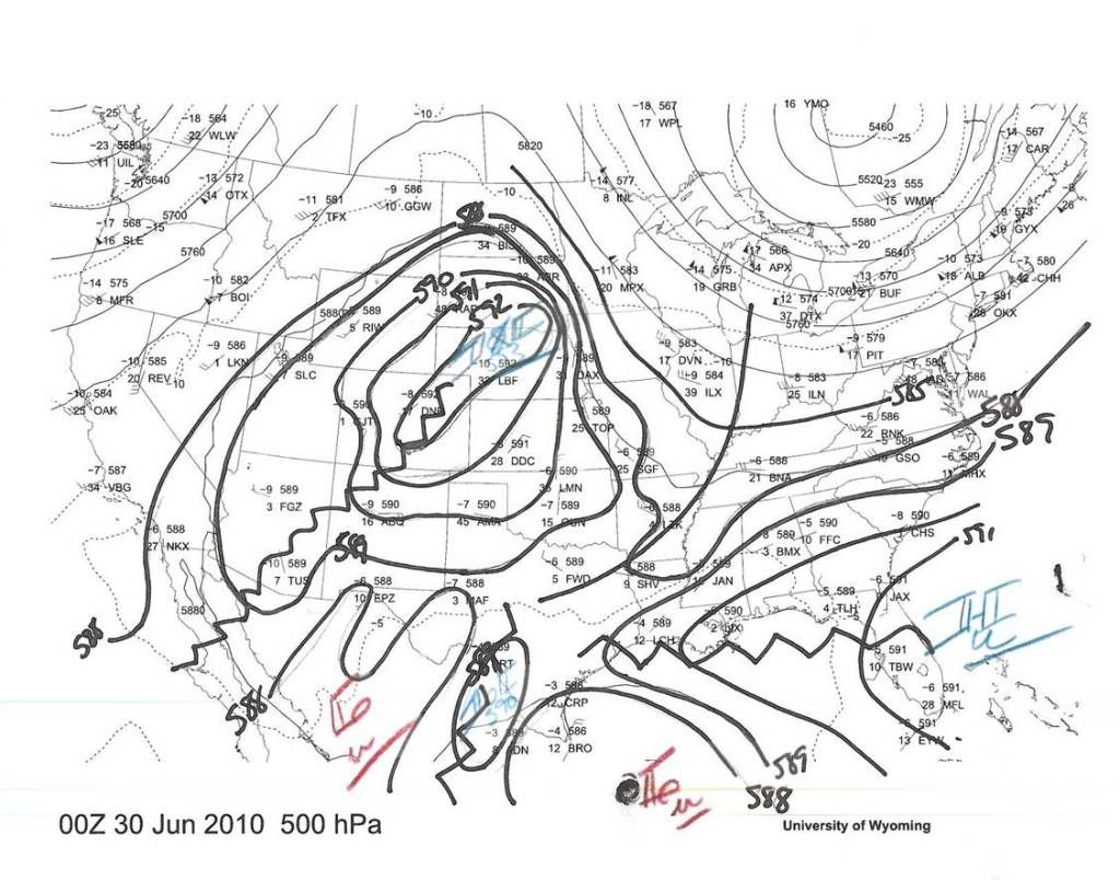
Air Force Met wrote:Here is the 00z 500 mb from last night that I hand analyzed every 10mb. It explains the current slow movement and the recent NNW motion. There is the break that Stewart mentioned in the 4am discussion.

Deltadog and I were looking at this trof coming down a couple of nights ago and wondering what impact it would have on the track. We were at a loss since none of the models showed it having an influence...yet it was there breaking down the ridge in NE TX. We felt it had to move north some in response...but at the same time the models had to be seeing something to be in such good agreement.

Image


Thanks for posting your chart.
I was looking at the CIMISS steering maps and noticed that the ridge over Neb is weakening but I couldn't see the little ridge over Texas if that is a separate one. from what you're saying do you think a WNW to NW movement is likely till landfall? Just trying to learn here.
0 likes   
The following post is NOT an official forecast and should not be used as such. It is just the opinion of the poster and may or may not be backed by sound meteorological data. It is NOT endorsed by any professional institution including storm2k.org For Official Information please refer to the NHC and NWS products.

User avatar
TeamPlayersBlue
Category 5
Category 5
Posts: 3445
Joined: Tue Feb 02, 2010 1:44 am
Location: Denver/Applewood, CO

Re: ATL: HURRICANE ALEX - DISCUSSION

#4025 Postby TeamPlayersBlue » Wed Jun 30, 2010 8:05 am

PauleinHouston wrote:Brownsville long range radar loop...

http://radar.weather.gov/radar.php?product=N0Z&rid=BRO&loop=yes

Definitely a N/NW movement at this point


Um thats not good. Doesn't have that "wobble" look to it either. To me the wobble look has a kind of roll to it. This looks to be a direct movement. These storms do this sort of thing nearing land though so we will have to see. Not sure if anyone knows what im talking about lol.
0 likes   
Personal Forecast Disclaimer:
The posts in this forum are NOT official forecast and should not be used as such. They are just the opinion of the poster and may or may not be backed by sound meteorological data. They are NOT endorsed by any professional institution or storm2k.org. For official information, please refer to the NHC and NWS products.

User avatar
AdamFirst
S2K Supporter
S2K Supporter
Posts: 2491
Age: 36
Joined: Thu Aug 14, 2008 10:54 am
Location: Port Saint Lucie, FL

#4026 Postby AdamFirst » Wed Jun 30, 2010 8:09 am

Looks like an eye is beginning to form on the first visible images.
0 likes   
Dolphins Marlins Canes Golden Panthers HEAT
Andrew 1992 - Irene 1999 - Frances 2004 - Jeanne 2004 - Wilma 2005 - Fay 2008 - Isaac 2012 - Matthew 2016 - Irma 2017 - Dorian 2019 - Ian 2022 - Nicole 2022 - Milton 2024

tolakram
Admin
Admin
Posts: 20010
Age: 62
Joined: Sun Aug 27, 2006 8:23 pm
Location: Florence, KY (name is Mark)

Re: ATL: HURRICANE ALEX - DISCUSSION

#4027 Postby tolakram » Wed Jun 30, 2010 8:09 am

Enhanced first visible:

Image
0 likes   
M a r k
- - - - -
Join us in chat: Storm2K Chatroom Invite. Android and IOS apps also available.

The posts in this forum are NOT official forecasts and should not be used as such. Posts are NOT endorsed by any professional institution or STORM2K.org. For official information and forecasts, please refer to NHC and NWS products.

User avatar
tailgater
S2K Supporter
S2K Supporter
Posts: 3339
Joined: Sun Jul 11, 2004 9:13 pm
Location: St. Amant La.

Re: ATL: HURRICANE ALEX - DISCUSSION

#4028 Postby tailgater » Wed Jun 30, 2010 8:11 am

TeamPlayersBlue wrote:
PauleinHouston wrote:Brownsville long range radar loop...

http://radar.weather.gov/radar.php?product=N0Z&rid=BRO&loop=yes

Definitely a N/NW movement at this point


Um thats not good. Doesn't have that "wobble" look to it either. To me the wobble look has a kind of roll to it. This looks to be a direct movement. These storms do this sort of thing nearing land though so we will have to see. Not sure if anyone knows what im talking about lol.


Yeah on both points. but as they near the coast, they seem to shy away at first. especially if they are coming in at angle.
0 likes   
The following post is NOT an official forecast and should not be used as such. It is just the opinion of the poster and may or may not be backed by sound meteorological data. It is NOT endorsed by any professional institution including storm2k.org For Official Information please refer to the NHC and NWS products.

User avatar
KWT
Category 5
Category 5
Posts: 31415
Joined: Tue Aug 17, 2004 11:02 am
Location: UK!!!

#4029 Postby KWT » Wed Jun 30, 2010 8:12 am

Sure does look like its really moving northwards in the last hour or so looking at that radar, of course the system is a long way out from radar but thats very interesting...

Not impossible it hits outside the cone if it keeps this trend up for a few hours then bends back...of course it carried it till landfall then it'd probably mean S.Texas would probably get some higher winds then they were expecting, esp because that northern band above the eyewall probably has 50-60kts sustained.
0 likes   
Personal Forecast Disclaimer:
The posts in this forum are NOT official forecast and should not be used as such. They are just the opinion of the poster and may or may not be backed by sound meteorological data. They are NOT endorsed by any professional institution or storm2k.org. For official information, please refer to the NHC and NWS products

User avatar
HURAKAN
Professional-Met
Professional-Met
Posts: 46086
Age: 38
Joined: Thu May 20, 2004 4:34 pm
Location: Key West, FL
Contact:

#4030 Postby HURAKAN » Wed Jun 30, 2010 8:19 am

Image

Latest
0 likes   

WacoWx
Category 2
Category 2
Posts: 664
Joined: Mon Dec 28, 2009 4:14 pm
Location: NOT Waco, TX ----> Dallas, TX

Re: ATL: HURRICANE ALEX - DISCUSSION

#4031 Postby WacoWx » Wed Jun 30, 2010 8:21 am

I remember with Katrina, the Mets were talking about the amount of 'kinetic energy' the storm had due to its wide ranging scope. Why havent i heard anything about the kinetic energy of Alex? It seems the sprawl of this storm would at least warrant mentioning, no?
0 likes   

User avatar
HURAKAN
Professional-Met
Professional-Met
Posts: 46086
Age: 38
Joined: Thu May 20, 2004 4:34 pm
Location: Key West, FL
Contact:

Re: ATL: HURRICANE ALEX - DISCUSSION

#4032 Postby HURAKAN » Wed Jun 30, 2010 8:22 am

30/1145 UTC 23.6N 95.3W T5.5/5.5 ALEX -- Atlantic

100 knots - funny how estimates and reality work!!!
0 likes   

User avatar
thetruesms
Professional-Met
Professional-Met
Posts: 844
Age: 41
Joined: Thu Aug 16, 2007 1:14 pm
Location: Tallahasee, FL
Contact:

Re: ATL: HURRICANE ALEX - DISCUSSION

#4033 Postby thetruesms » Wed Jun 30, 2010 8:24 am

Air Force Met wrote:[img]http://i1000.photobucket.com/albums/af129/kerux123/500mb-30jun-00z001-1.jpg[img]
It seemed like the thread had gone all kinds of wonky, and then I come across a pretty hand analysis. Which reminds me that this would be a perfect activity with the 12Z set (assuming it gets in in time) while I sit through a conference call I observe, but don't really take a part in :oops:

Musings on things that have happened while I was asleep/coming in/covering other responsibilities:
- It looks like overnight Alex was well on the way to clearing out an eye, but it kind of seems to have given up on that for the time being
- Taking a look at BRO's radar, I've been following AFM's thoughts on it going 350 recently, but it looks like it's starting to bend back now
0 likes   

xironman
S2K Supporter
S2K Supporter
Posts: 2522
Joined: Sun Jun 10, 2007 4:53 pm
Location: NoVA

Re: ATL: HURRICANE ALEX - DISCUSSION

#4034 Postby xironman » Wed Jun 30, 2010 8:26 am

He is in no hurry to go anywhere

Image
0 likes   

tolakram
Admin
Admin
Posts: 20010
Age: 62
Joined: Sun Aug 27, 2006 8:23 pm
Location: Florence, KY (name is Mark)

Re: ATL: HURRICANE ALEX - DISCUSSION

#4035 Postby tolakram » Wed Jun 30, 2010 8:36 am

Looks like an eye trying to clear out again.

Image
0 likes   
M a r k
- - - - -
Join us in chat: Storm2K Chatroom Invite. Android and IOS apps also available.

The posts in this forum are NOT official forecasts and should not be used as such. Posts are NOT endorsed by any professional institution or STORM2K.org. For official information and forecasts, please refer to NHC and NWS products.

User avatar
Bocadude85
Category 5
Category 5
Posts: 2991
Age: 38
Joined: Mon Apr 18, 2005 2:20 pm
Location: Honolulu,Hi

Re: ATL: HURRICANE ALEX - DISCUSSION

#4036 Postby Bocadude85 » Wed Jun 30, 2010 8:37 am

I think the eventual landfall will still be in Mexico but a little closer to Brownsville then was expected
0 likes   

tolakram
Admin
Admin
Posts: 20010
Age: 62
Joined: Sun Aug 27, 2006 8:23 pm
Location: Florence, KY (name is Mark)

Re: ATL: HURRICANE ALEX - DISCUSSION

#4037 Postby tolakram » Wed Jun 30, 2010 8:38 am

Longer and faster radar loop:

Image
0 likes   
M a r k
- - - - -
Join us in chat: Storm2K Chatroom Invite. Android and IOS apps also available.

The posts in this forum are NOT official forecasts and should not be used as such. Posts are NOT endorsed by any professional institution or STORM2K.org. For official information and forecasts, please refer to NHC and NWS products.

User avatar
PTrackerLA
Category 5
Category 5
Posts: 5277
Age: 41
Joined: Thu Oct 10, 2002 8:40 pm
Location: Lafayette, LA

Re: ATL: HURRICANE ALEX - DISCUSSION

#4038 Postby PTrackerLA » Wed Jun 30, 2010 8:39 am

Impressive looking hurricane. I wonder what the record for lowest June pressure is? I see Audrey was 946mb.

Edit: Actually there are accounts of much lower pressure with Audrey, so I'm not really sure how low the pressure dropped.
Last edited by PTrackerLA on Wed Jun 30, 2010 8:41 am, edited 1 time in total.
0 likes   

jlauderdal
S2K Supporter
S2K Supporter
Posts: 7183
Joined: Wed May 19, 2004 5:46 am
Location: NE Fort Lauderdale
Contact:

Re: ATL: HURRICANE ALEX - DISCUSSION

#4039 Postby jlauderdal » Wed Jun 30, 2010 8:41 am

thetruesms wrote:
Air Force Met wrote:[img]http://i1000.photobucket.com/albums/af129/kerux123/500mb-30jun-00z001-1.jpg[img]
It seemed like the thread had gone all kinds of wonky, and then I come across a pretty hand analysis. Which reminds me that this would be a perfect activity with the 12Z set (assuming it gets in in time) while I sit through a conference call I observe, but don't really take a part in :oops:

Musings on things that have happened while I was asleep/coming in/covering other responsibilities:
- It looks like overnight Alex was well on the way to clearing out an eye, but it kind of seems to have given up on that for the time being
- Taking a look at BRO's radar, I've been following AFM's thoughts on it going 350 recently, but it looks like it's starting to bend back now


the hand analysis are the best, deltadog has produced some great ones in past years
0 likes   

User avatar
thetruesms
Professional-Met
Professional-Met
Posts: 844
Age: 41
Joined: Thu Aug 16, 2007 1:14 pm
Location: Tallahasee, FL
Contact:

Re: ATL: HURRICANE ALEX - DISCUSSION

#4040 Postby thetruesms » Wed Jun 30, 2010 8:41 am

WacoWx wrote:I remember with Katrina, the Mets were talking about the amount of 'kinetic energy' the storm had due to its wide ranging scope. Why havent i heard anything about the kinetic energy of Alex? It seems the sprawl of this storm would at least warrant mentioning, no?
The latest wind analysis from HRD had the wind Integrated Kinetic Energy for Alex as 24 TJ, with a wind Destructive Potential Rating (0-6 scale) of 1.2, and a surge DPR or 2.6. The downside is, it was from yesterday near noon, so not very valid anymore.

An estimate, based on the 09Z wind swaths and assuming a 9 nm eye (from recon), is an IKE of 51.3 TJ, with a surge DPR of 3.83
Last edited by thetruesms on Wed Jun 30, 2010 8:42 am, edited 1 time in total.
0 likes   


Return to “2010”

Who is online

Users browsing this forum: No registered users and 5 guests