Brazoria County has had a rough day...
SEVERE THUNDERSTORM WARNING
TXC039-157-012030-
/O.NEW.KHGX.SV.W.0047.100701T2005Z-100701T2030Z/
BULLETIN - EAS ACTIVATION REQUESTED
SEVERE THUNDERSTORM WARNING
NATIONAL WEATHER SERVICE HOUSTON/GALVESTON TX
305 PM CDT THU JUL 1 2010
THE NATIONAL WEATHER SERVICE IN LEAGUE CITY HAS ISSUED A
* SEVERE THUNDERSTORM WARNING FOR...
CENTRAL BRAZORIA COUNTY IN SOUTHEAST TEXAS...
SOUTHERN FORT BEND COUNTY IN SOUTHEAST TEXAS...
* UNTIL 330 PM CDT
* AT 301 PM CDT...NATIONAL WEATHER SERVICE DOPPLER RADAR INDICATED A
SEVERE THUNDERSTORM. THIS STORM WAS LOCATED NEAR HOLIDAY LAKES...
OR 7 MILES NORTHEAST OF WEST COLUMBIA...AND MOVING NORTH AT 20 MPH.
* LOCATIONS IN THE SEVERE THUNDERSTORM WARNING INCLUDE BUT ARE NOT
LIMITED TO BRAZOS BEND STATE PARK.
SE TX/SW LA weather: Much cooler and WET after Tuesday
Moderator: S2k Moderators
Forum rules

The posts in this forum are NOT official forecast and should not be used as such. They are just the opinion of the poster and may or may not be backed by sound meteorological data. They are NOT endorsed by any professional institution or STORM2K.
-
srainhoutx

- S2K Supporter

- Posts: 6919
- Age: 68
- Joined: Sun Jan 14, 2007 11:34 am
- Location: Haywood County, NC
- Contact:
Re: SE TX/SW LA weather: HOT!!-Watch the tropics
0 likes
Carla/Alicia/Jerry(In The Eye)/Michelle/Charley/Ivan/Dennis/Katrina/Rita/Wilma/Ike/Harvey
Member: National Weather Association
Wx Infinity Forums
http://wxinfinity.com/index.php
Facebook.com/WeatherInfinity
Twitter @WeatherInfinity
Member: National Weather Association
Wx Infinity Forums
http://wxinfinity.com/index.php
Facebook.com/WeatherInfinity
Twitter @WeatherInfinity
Re: SE TX/SW LA weather: HOT!!-Watch the tropics
Why is there this dry area in central Texas right now? It's like a little mini High pressure or something.
If you look at the loop radar the rain is just rotating around this dry circle.
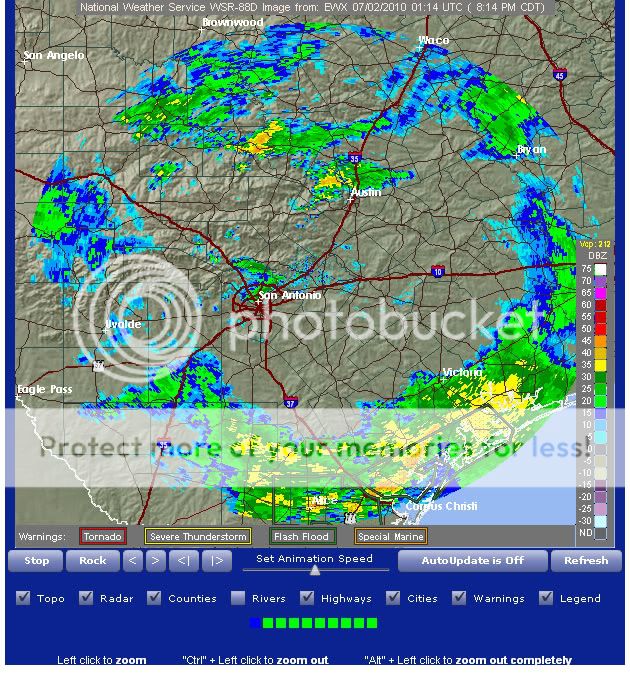
If you look at the loop radar the rain is just rotating around this dry circle.
0 likes
-
southerngale

- Retired Staff

- Posts: 27418
- Joined: Thu Oct 10, 2002 1:27 am
- Location: Southeast Texas (Beaumont area)
We've gotten quite a bit of rain the past few days. It looks like more on tap for tomorrow and possibly Saturday as well. I hope the rain ends by tomorrow night, though. I'd like to put my order in for no rain Saturday or Sunday, please.
NWS has reissued the Flood Watch for portions of SE TX AND SW LA.
NWS has reissued the Flood Watch for portions of SE TX AND SW LA.
Flash Flood Watch
FLOOD WATCH
NATIONAL WEATHER SERVICE LAKE CHARLES LA
1050 PM CDT THU JUL 1 2010
...FLOODING RAINS POSSIBLE THROUGH FRIDAY AFTERNOON...
.THE ENVELOPE OF TROPICAL AIR WHICH CONTAINS THE REMNANTS OF HURRICANE
ALEX WILL CONTINUE TO PROVIDE A RICH ENVIRONMENT FOR THUNDERSTORMS
WITH HEAVY RAINFALL AGAIN DURING THE AFTERNOON AND EARLY EVENING HOURS
ON FRIDAY.
LAZ041>045-051>055-TXZ215-216-020900-
/O.CON.KLCH.FF.A.0001.000000T0000Z-100703T0000Z/
/00000.0.ER.000000T0000Z.000000T0000Z.000000T0000Z.OO/
CALCASIEU-JEFFERSON DAVIS-ACADIA-LAFAYETTE-UPPER ST. MARTIN-
CAMERON-VERMILION-IBERIA-ST. MARY-LOWER ST. MARTIN-JEFFERSON-
ORANGE-
INCLUDING THE CITIES OF...LAKE CHARLES...JENNINGS...CROWLEY...
LAFAYETTE...ST. MARTINVILLE...CAMERON...ABBEVILLE...NEW IBERIA...
MORGAN CITY...BEAUMONT/PORT ARTHUR...ORANGE
1050 PM CDT THU JUL 1 2010
...FLASH FLOOD WATCH REMAINS IN EFFECT THROUGH FRIDAY EVENING...
THE FLASH FLOOD WATCH CONTINUES FOR
* PORTIONS OF LOUISIANA AND SOUTHEAST TEXAS...INCLUDING THE
FOLLOWING AREAS...IN LOUISIANA...ACADIA...CALCASIEU...
CAMERON...IBERIA...JEFFERSON DAVIS...LAFAYETTE...LOWER ST.
MARTIN...ST. MARY...UPPER ST. MARTIN AND VERMILION. IN
SOUTHEAST TEXAS...JEFFERSON AND ORANGE.
* THROUGH FRIDAY EVENING
*VERY HIGH MOISTURE CONTENT WILL COMBINE WITH DAYTIME HEATING AND
A WEAK FRONTAL BOUNDARY TO THE NORTH TO PRODUCE ANOTHER ROUND OF
NUMEROUS THUNDERSTORMS WITH TORRENTIAL DOWNPOURS ON FRIDAY.
*ACCUMULATED RAINFALL ESTIMATES FROM REPORTS AND RADAR INDICATE
THAT 1 TO 8 INCHES OF RAIN HAS FALLEN OVER THE WATCH AREA SINCE
TROPICAL RAINS FROM ALEX BEGAN MONDAY EVENING. RAINFALL TOTALS OF
2 TO 4 INCHES REMAIN POSSIBLE INTO FRIDAY EVENING.
PRECAUTIONARY/PREPAREDNESS ACTIONS...
A FLASH FLOOD WATCH MEANS THAT CONDITIONS MAY DEVELOP THAT LEAD
TO FLASH FLOODING. FLASH FLOODING IS A VERY DANGEROUS SITUATION.
REMEMBER...TURN AROUND...DON`T DROWN... WHEN YOU SEE FLOODED
ROADWAYS.
YOU SHOULD MONITOR LATER FORECASTS AND BE PREPARED TO TAKE ACTION
SHOULD FLASH FLOOD WARNINGS BE ISSUED.
&&
$$
SWEENEY
0 likes
Please support Storm2k by making a donation today. It is greatly appreciated! Click here: 
 my Cowboys my Rockets my Astros
my Cowboys my Rockets my Astros-
southerngale
- Retired Staff
- Posts: 27418
- Joined: Thu Oct 10, 2002 1:27 am
- Location: Southeast Texas (Beaumont area)
Re: SE TX/SW LA weather: HOT!!-Watch the tropics
Rain chances have gone UP for Saturday and Sunday. *sigh* A little tropical talk from the overnight LCH NWS crew. The first low mentioned has since been given a low chance of development by the NHC, shaded in yellow. I'll post that below the snippets from NWS discussion.
MOST MODELS DO WANT TO DEVELOP A LOW ON THE FRONTAL SYSTEM OVER
THE WEEKEND AND MOVE IT BACK TO THE WEST IN THE EASTERLY FLOW.
MODELS DEVELOP THIS SYSTEM TO VARYING DEGREES WITH THE GFS AND NAM
DEVELOPING A WARM CORE SYSTEM. THE EUROPEAN CENTER AND THE GFS
PARALLEL IS MUCH WEAKER WITH THIS SYSTEM AND IS THE PREFERRED
SOLUTION AT THIS TIME. NONE THE LESS WILL CONTINUE TO BE DEEP
EASTERLY FLOW WITH ABOVE NORMAL RAINFALL POTENTIAL.
LONG TERM...SHOULD CONTINUE TO BE OVERALL ABOVE NORMAL RAIN
CHANCES THROUGH THE LONG TERM AS DEEP EASTERLY FLOW CONTINUES
AROUND THE BERMUDA HIGH. THE ECMWF AND THE GFS PARALLEL HINT AT
SOME DEVELOPMENT MID TO LATE NEXT WEEK IN THE SOUTHERN GULF. AT
THIS TIME JUST FORECASTING A PASSING EASTERLY WAVE.
Edit: And from the HOU NWS overnight discussion:
BUT THEN
IT GETS A BIT MORE INTERESTING AS MODELS CONTINUE TO BRING A LOW
WEST ALONG THE OLD FRONTAL BOUNDARY IN THE NE GULF. THE ECMWF
PLACES A VERY WEAK CIRCULATION IN THE UTCW...THE NAM SOUTH OF
HOUMA LA AND THE GFS NEAR THE MISSISSIPPI COAST. WEAK SHEAR IN THE
VICINITY OF THE SUSPECTED LOW WARRANTS CLOSE MONITORING OF THE
REGION BUT THE UPPER RIDGING ACROSS N TEXAS SHOULD FAVOR THE
SYSTEM NOT GETTING THIS FAR WEST...A DEFINITE STAY TUNED. AND THEN
AS IF THAT ISN`T BAD ENOUGH...THE NAM/GFS/ECMWF ARE ALL WORKING A
TROPICAL WAVE INTO A TIZZY IN THE WESTERN CARIBBEAN ON MONDAY
UNFORTUNATELY THE SAME UPPER RIDGING SHOULD BE FLATTENING AND
SHIFTING EAST OPENING UP THE WESTERN GULF TO THIS WAVE/TROPICAL
SYSTEM. INTERESTINGLY THE 00Z ECMWF LOOKS LIKE THE 18Z GFS WHICH
HAS IT NEARING THE TEXAS COAST FRIDAY THE 9TH. IT IS STILL TO
EARLY TO HANG A HAT ON THIS SOLUTION BUT SHOULD STILL POINT TO THE
POSSIBILITY OF SOMETHING OF INTEREST IN THE WESTERN GULF. RAIN
CHANCES SHOULD BE COMING DOWN MONDAY AND TUESDAY AS MOISTURE THINS
AND UPPER RIDGING CREEPS SOUTHWARD.
MOST MODELS DO WANT TO DEVELOP A LOW ON THE FRONTAL SYSTEM OVER
THE WEEKEND AND MOVE IT BACK TO THE WEST IN THE EASTERLY FLOW.
MODELS DEVELOP THIS SYSTEM TO VARYING DEGREES WITH THE GFS AND NAM
DEVELOPING A WARM CORE SYSTEM. THE EUROPEAN CENTER AND THE GFS
PARALLEL IS MUCH WEAKER WITH THIS SYSTEM AND IS THE PREFERRED
SOLUTION AT THIS TIME. NONE THE LESS WILL CONTINUE TO BE DEEP
EASTERLY FLOW WITH ABOVE NORMAL RAINFALL POTENTIAL.
LONG TERM...SHOULD CONTINUE TO BE OVERALL ABOVE NORMAL RAIN
CHANCES THROUGH THE LONG TERM AS DEEP EASTERLY FLOW CONTINUES
AROUND THE BERMUDA HIGH. THE ECMWF AND THE GFS PARALLEL HINT AT
SOME DEVELOPMENT MID TO LATE NEXT WEEK IN THE SOUTHERN GULF. AT
THIS TIME JUST FORECASTING A PASSING EASTERLY WAVE.
ZCZC MIATWOAT ALL
TTAA00 KNHC DDHHMM
TROPICAL WEATHER OUTLOOK
NWS TPC/NATIONAL HURRICANE CENTER MIAMI FL
800 AM EDT FRI JUL 2 2010
FOR THE NORTH ATLANTIC...CARIBBEAN SEA AND THE GULF OF MEXICO...
1. A WEAK NON-TROPICAL LOW PRESSURE AREA...ASSOCIATED WITH A FRONTAL
ZONE...CENTERED OVER THE EXTREME NORTHEASTERN GULF OF MEXICO IS
EXPECTED TO DRIFT WESTWARD DURING THE NEXT DAY OR TWO. THIS LOW
WILL BE MONITORED FOR ANY SIGNS OF TROPICAL OR SUBTROPICAL
DEVELOPMENT. THERE IS A LOW CHANCE...10 PERCENT...OF THIS SYSTEM
BECOMING A TROPICAL OR SUBTROPICAL CYCLONE DURING THE NEXT 48
HOURS.
ELSEWHERE...TROPICAL CYCLONE FORMATION IS NOT EXPECTED DURING THE
NEXT 48 HOURS.
$$
FORECASTER AVILA/LANDSEA
NNNN
Edit: And from the HOU NWS overnight discussion:
BUT THEN
IT GETS A BIT MORE INTERESTING AS MODELS CONTINUE TO BRING A LOW
WEST ALONG THE OLD FRONTAL BOUNDARY IN THE NE GULF. THE ECMWF
PLACES A VERY WEAK CIRCULATION IN THE UTCW...THE NAM SOUTH OF
HOUMA LA AND THE GFS NEAR THE MISSISSIPPI COAST. WEAK SHEAR IN THE
VICINITY OF THE SUSPECTED LOW WARRANTS CLOSE MONITORING OF THE
REGION BUT THE UPPER RIDGING ACROSS N TEXAS SHOULD FAVOR THE
SYSTEM NOT GETTING THIS FAR WEST...A DEFINITE STAY TUNED. AND THEN
AS IF THAT ISN`T BAD ENOUGH...THE NAM/GFS/ECMWF ARE ALL WORKING A
TROPICAL WAVE INTO A TIZZY IN THE WESTERN CARIBBEAN ON MONDAY
UNFORTUNATELY THE SAME UPPER RIDGING SHOULD BE FLATTENING AND
SHIFTING EAST OPENING UP THE WESTERN GULF TO THIS WAVE/TROPICAL
SYSTEM. INTERESTINGLY THE 00Z ECMWF LOOKS LIKE THE 18Z GFS WHICH
HAS IT NEARING THE TEXAS COAST FRIDAY THE 9TH. IT IS STILL TO
EARLY TO HANG A HAT ON THIS SOLUTION BUT SHOULD STILL POINT TO THE
POSSIBILITY OF SOMETHING OF INTEREST IN THE WESTERN GULF. RAIN
CHANCES SHOULD BE COMING DOWN MONDAY AND TUESDAY AS MOISTURE THINS
AND UPPER RIDGING CREEPS SOUTHWARD.
0 likes
Please support Storm2k by making a donation today. It is greatly appreciated! Click here:
my Cowboys my Rockets my Astros
my Cowboys my Rockets my Astros-
vbhoutex

- Storm2k Executive

- Posts: 29149
- Age: 74
- Joined: Wed Oct 09, 2002 11:31 pm
- Location: Cypress, TX
- Contact:
Re: SE TX/SW LA weather: HOT!!-Watch the tropics
I emptied 1.9" from the gauge this morning and it is still raining. Radar shows some backbuilding of some of the heavier showers in our area which is not good if this is going to continue all day. Some of the local OCMs were talking up to a foot of rain today last night, but I have my doubts about that. Not that I haven't seen it happen here before, but we sure don't need that much rain!! I am adding my order to SGs for no rain over the weekend!! Looking down the road, I hope the models are wrong about anything spinning up anytime soon and heading into the GOM!! Even the possible spin up in the NE GOM on the old frontal boundary is worrisome. We've all seen what those spin ups can do in the past. 
0 likes
Skywarn, C.E.R.T.
Please click below to donate to STORM2K to help with the expenses of keeping the site going:
Please click below to donate to STORM2K to help with the expenses of keeping the site going:
-
JenBayles

- Category 5

- Posts: 3461
- Age: 63
- Joined: Tue Aug 26, 2003 3:27 pm
- Location: Houston, TX
- Contact:
Totally agree David. Get that old frontal boundary OUT of here! Got 1.75" through yesterday evening, and another 1.75 on top of that at 8:45 this morning. Was really surprised by the downpour that woke me up at 2:45 this morning too. I hoped the atmosphere would have stabilized enough for storms to hold off until after sunrise. Was I ever wrong!
0 likes
-
srainhoutx
- S2K Supporter
- Posts: 6919
- Age: 68
- Joined: Sun Jan 14, 2007 11:34 am
- Location: Haywood County, NC
- Contact:
Re: SE TX/SW LA weather: HOT!!-Watch the tropics
Already 2 inches since 7 AM this morning. Out of town guests are driving in from FL for a long 4th of July weekend. Hopefull we will get a break before Sunday.
0 likes
Carla/Alicia/Jerry(In The Eye)/Michelle/Charley/Ivan/Dennis/Katrina/Rita/Wilma/Ike/Harvey
Member: National Weather Association
Wx Infinity Forums
http://wxinfinity.com/index.php
Facebook.com/WeatherInfinity
Twitter @WeatherInfinity
Member: National Weather Association
Wx Infinity Forums
http://wxinfinity.com/index.php
Facebook.com/WeatherInfinity
Twitter @WeatherInfinity
-
weatherguy425
- Tropical Storm

- Posts: 180
- Joined: Sun Aug 16, 2009 1:06 pm
- Location: Houston, TX > Lubbock, TX > Savannah, GA
- Contact:
Re: SE TX/SW LA weather: HOT!!-Watch the tropics
It's interesting to watch the storms firing out in the gulf, they"re being "sucked in" by the cluster currently over houston.
0 likes
Re: SE TX/SW LA weather: HOT!!-Watch the tropics
Yeah finally received some rain beginning about 3 am and has been raining off an on since then. Yesterday emptied a whopping .05" out of the rain guage. Then again, my dog may have just sneezed on the rain guage  ! I am starting to become concerned about possibility in the Gulf.
0 likes
-
srainhoutx
- S2K Supporter
- Posts: 6919
- Age: 68
- Joined: Sun Jan 14, 2007 11:34 am
- Location: Haywood County, NC
- Contact:
Re: SE TX/SW LA weather: HOT!!-Watch the tropics
From Nesdis...
SATELLITE PRECIPITATION ESTIMATES..DATE/TIME 07/02/10 1641Z
SATELLITE ANALYSIS BRANCH/NESDIS---NPPU---TEL.301-763-8678
LATEST DATA USED: GOES-13 1615Z JBN
TRMM: 1402Z
.
LOCATION...TEXAS...
.
ATTN WFOS...LCH...HGX...FWD...CRP...EWX...SJT...
ATTN RFCS...WGRFC...
.
EVENT...MOD/HVY RAIN WITH BAND OF CONVECTION OVER ERN TX
.
SATELLITE ANALYSIS AND TRENDS...LATEST GOES IR/VIS IMAGERY CONTINUES TO
SHOW THAT CONVECTION IS DEVELOPING ALONG THE TX COAST/NWRN GULF OF MEXICO
AND IS MOVING NW INTO CNTRL TX. THE CONVECTION HAS CONSOLIDATED A BIT THE
PAST FEW HRS INTO A MORE CONCENTRATED BAND BETWEEN KIAH AND KCRP THAT IS
FEEDING NW. THE DEEPEST CONVECTION AND HEAVIEST RAIN THREAT HAS BEEN AND
REMAINS NEAR THE IMMEDIATE COAST AND JUST INLAND WHERE CLOUD TOPS ARE
SHOWING A STRONG COOLING/EXPANDING TREND IN IR IMAGERY. THIS CONVECTION
THEN FEEDS NW INTO CNTRL TX WHERE IT CLOUD TOPS HAVE BEEN WARMING AND
THERE HAS BEEN MORE OF A STEADIER MOD/HVY RAIN EVENT. THE MOST RECENT
TRMM PASS ESTIMATED MAX AREAL AVERAGED RAIN RATES OF 0.5-1.0"/HR MAY
HAVE BEEN OCCURRING WITH THE CONVECTION OVER COASTAL TX. HOWEVER, RAIN
RATES MAY BE A BIT HIGHER OR LOWER FROM TIME TO TIME AS CONVECTION HAS
BEEN RAPIDLY DEVELOPING AND DISSIPATING OVER THE COURSE OF THE PAST FEW
HRS. FARTHER INLAND, RAIN RATES OF 0.25-0.50"/HR MAY BE OCCURRING BASED ON
THE TRMM PASS AS WELL. THE CONVECTION SHOULD CONTINUE ON ITS NWWD TRACK
THE NEXT FEW HRS KEEPING THE THREAT FOR MOD/HVY RAIN ALIVE. ADDITIONAL
RAINFALL AMOUNTS OF 1-2" WILL BE POSSIBLE CLOSE TO THE COAST OF TX WITH
LESSER AMOUNTS OF 0.5-1.0" POSSIBLE FARTHER NW TOWARD CNTRL TX.
.
SHORT TERM OUTLOOK VALID 1645Z-1945Z...MEDIUM CONFIDENCE FACTOR IN
THE SHORT TERM OUTLOOK BASED ON RECENT TRENDS IN SATELLITE IMAGERY. THE
DEEPEST CONVECTION HAS HAD SOME TROUBLE MAKING IT INLAND AND HAS LINGERED
ALONG THE COAST THE PAST FEW HRS. THIS SHOULD REMAIN THE CASE THE NEXT FEW
HRS AND THE HEAVIEST RAIN SHOULD BE CONFINED TO COASTAL AREAS. HOWEVER,
AS THE CONVECTION CONTINUES NWWD INTO CNTRL TX AND WEAKENS SOME, MOD/HVY
RAIN MAY REMAIN A POSSIBILITY.
0 likes
Carla/Alicia/Jerry(In The Eye)/Michelle/Charley/Ivan/Dennis/Katrina/Rita/Wilma/Ike/Harvey
Member: National Weather Association
Wx Infinity Forums
http://wxinfinity.com/index.php
Facebook.com/WeatherInfinity
Twitter @WeatherInfinity
Member: National Weather Association
Wx Infinity Forums
http://wxinfinity.com/index.php
Facebook.com/WeatherInfinity
Twitter @WeatherInfinity
Re: SE TX/SW LA weather: HOT!!-Watch the tropics
So far I have received 1.6" since 3 am today. Not bad for us in the great North and I did see rain chances are on the increase once again.
0 likes
-
vbhoutex
- Storm2k Executive
- Posts: 29149
- Age: 74
- Joined: Wed Oct 09, 2002 11:31 pm
- Location: Cypress, TX
- Contact:
Re: SE TX/SW LA weather: HOT!!-Watch the tropics
I can't tell from the house or porch how much we have had since 8am when I emptied the gauge. It is either 1/2" or almost 2", but the cylinder is fogged up so I can't see the inner tube clearly(CoCoRahs guage). I do know it has rained on and off all day and more on than off to say the least. The radar continues to show waves of heavier rain moving in from the SE so I don't see an end to this any time soon.  This could turn out to be a very soggy 4th of July weekend.
 Invest 95L is more fly in the ointment if it decides to move our way instead of into LA as currently progged. What would be great is 95L going POOF! Stay dry and safe everyone!
edit: Just in from Jeff:
edit: Just in from Jeff:
Very heavy rainfall continues to develop and train over Brazoria, Fort Bend and Harris Counties.
Portions of Brazoria County have now had up to 12” of rainfall since yesterday morning. Widespread flooding is developing over the western part of Brazoria County into southern Fort Bend. Excessive rainfall rates of 2-3 inches per hour will affect the areas along and west of I-45 over the next 2-4 hours. Flash flooding will be developing with saturated grounds in place with street flooding likely.
0 likes
Skywarn, C.E.R.T.
Please click below to donate to STORM2K to help with the expenses of keeping the site going:
Please click below to donate to STORM2K to help with the expenses of keeping the site going:
-
vbhoutex
- Storm2k Executive
- Posts: 29149
- Age: 74
- Joined: Wed Oct 09, 2002 11:31 pm
- Location: Cypress, TX
- Contact:
Re: SE TX/SW LA weather: HOT!!-Watch the tropics
We now have a FFWarning for Harris County, an Urban and Small Stream Flood Advisory for Harris County, and a FFWatch for the metro area till Midnight. Can you say train? Radar continues to be full of yellow and red all the way to the coast. Just checked the gauge and there is over 2" in it and it is still raining, raining, raining. That will put us over 4" here at the house in the last 24 hours with most of it since midnight. Not flooding here yet. *vb crosses every appendage available* There is a silver lining here. We won't have any drought worries for a while. 
0 likes
Skywarn, C.E.R.T.
Please click below to donate to STORM2K to help with the expenses of keeping the site going:
Please click below to donate to STORM2K to help with the expenses of keeping the site going:
-
HouTXmetro

- Category 5
- Posts: 3949
- Joined: Sun Jun 13, 2004 6:00 pm
- Location: District of Columbia, USA
Re: SE TX/SW LA weather: HOT!!-Watch the tropics
Just saw on TV I-10 is beginning to flood in some places due to pump problems and the bayous are starting to over flow in some areas. Still not much here but don't want what is in Houston either.
0 likes
Re: SE TX/SW LA weather: HOT!!-Watch the tropics
We have received 2.5" since 3 am today. Well guess the forecast was correct as we were predicted to get 3 to 5" over a 5 day period. I was just not expecting most of that in less than 24 hours.
0 likes

-
vbhoutex
- Storm2k Executive
- Posts: 29149
- Age: 74
- Joined: Wed Oct 09, 2002 11:31 pm
- Location: Cypress, TX
- Contact:
Re: SE TX/SW LA weather: HOT!!-Watch the tropics
Just picked up a quick 0.40" in 10 min.!! I hope the rest of the storms today aren't like this one!!
0 likes
Skywarn, C.E.R.T.
Please click below to donate to STORM2K to help with the expenses of keeping the site going:
Please click below to donate to STORM2K to help with the expenses of keeping the site going:
Re: SE TX/SW LA weather: HOT!!-Watch the tropics
I'm in between storms right now. They are to the East and West and appear very heavy. I'm hoping it will fill in as the day goes on, but do not want any flooding!
0 likes
Return to “USA & Caribbean Weather”
Who is online
Users browsing this forum: Brushcountry and 123 guests