ATL: TROPICAL DEPRESSION TWO - DISCUSSION
Moderator: S2k Moderators
-
sphelps8681
- Category 2

- Posts: 785
- Joined: Thu Aug 16, 2007 5:37 pm
- Location: Somewhere over the rainbow
Re: ATL: INVEST 96L - DISCUSSION
TWC Dr. Knab just said this am not going to be today. They don't do flights over land.
0 likes

Ah thats fair enough, unless they think the center maybe offland still but we shall see...
Still held at 30% which means they probably won't bother going anyway today.
Still held at 30% which means they probably won't bother going anyway today.
0 likes
Personal Forecast Disclaimer:
The posts in this forum are NOT official forecast and should not be used as such. They are just the opinion of the poster and may or may not be backed by sound meteorological data. They are NOT endorsed by any professional institution or storm2k.org. For official information, please refer to the NHC and NWS products
The posts in this forum are NOT official forecast and should not be used as such. They are just the opinion of the poster and may or may not be backed by sound meteorological data. They are NOT endorsed by any professional institution or storm2k.org. For official information, please refer to the NHC and NWS products

Re: ATL: INVEST 96L - DISCUSSION
Does appear there may be a lower shear environment for invest 96 once it gets back out over the gulf.
The Texas coast makes it tough to narrow in on a landfall for a storm moving north or northwest. It will be a challenge for the NHC to forecast the track as well with 96L as they did with Alex.
Aric hasn't issued any speculations yet so I guess we can wait another day.
The Texas coast makes it tough to narrow in on a landfall for a storm moving north or northwest. It will be a challenge for the NHC to forecast the track as well with 96L as they did with Alex.
Aric hasn't issued any speculations yet so I guess we can wait another day.
0 likes
I think 96L is probably heading for C.Texas....the models don't seem very keen on this developing at all now though and I think the odds of development overall before landfall is starting to go down now as it doesn't look to me like its getting any more organised really...
0 likes
Personal Forecast Disclaimer:
The posts in this forum are NOT official forecast and should not be used as such. They are just the opinion of the poster and may or may not be backed by sound meteorological data. They are NOT endorsed by any professional institution or storm2k.org. For official information, please refer to the NHC and NWS products
The posts in this forum are NOT official forecast and should not be used as such. They are just the opinion of the poster and may or may not be backed by sound meteorological data. They are NOT endorsed by any professional institution or storm2k.org. For official information, please refer to the NHC and NWS products
-
johngaltfla

- Category 5

- Posts: 2073
- Joined: Sun Jul 10, 2005 9:17 pm
- Location: Sarasota County, FL
- Contact:
Re: ATL: INVEST 96L - DISCUSSION
I honestly think that if it doesn't develop and just stays an open wave, you won't hear any hearts breaking in the GOM. We really need the Gulf to remain storm free until the relief wells are finished and cap that disaster.
0 likes
-
srainhoutx

- S2K Supporter

- Posts: 6919
- Age: 68
- Joined: Sun Jan 14, 2007 11:34 am
- Location: Haywood County, NC
- Contact:
Re: ATL: INVEST 96L - DISCUSSION
Sunrise over the Yucatan...
0 likes
Carla/Alicia/Jerry(In The Eye)/Michelle/Charley/Ivan/Dennis/Katrina/Rita/Wilma/Ike/Harvey
Member: National Weather Association
Wx Infinity Forums
http://wxinfinity.com/index.php
Facebook.com/WeatherInfinity
Twitter @WeatherInfinity
Member: National Weather Association
Wx Infinity Forums
http://wxinfinity.com/index.php
Facebook.com/WeatherInfinity
Twitter @WeatherInfinity
Re: ATL: INVEST 96L - DISCUSSION
johngaltfla wrote:I honestly think that if it doesn't develop and just stays an open wave, you won't hear any hearts breaking in the GOM. We really need the Gulf to remain storm free until the relief wells are finished and cap that disaster.
To be honest given the surging SSE airflow at lwoer levels still, not sure its going to make a huge amount of difference to the oil spill if this developed or not really, wouldn't be much of a wind difference unless it got close to TS status.
0 likes
Personal Forecast Disclaimer:
The posts in this forum are NOT official forecast and should not be used as such. They are just the opinion of the poster and may or may not be backed by sound meteorological data. They are NOT endorsed by any professional institution or storm2k.org. For official information, please refer to the NHC and NWS products
The posts in this forum are NOT official forecast and should not be used as such. They are just the opinion of the poster and may or may not be backed by sound meteorological data. They are NOT endorsed by any professional institution or storm2k.org. For official information, please refer to the NHC and NWS products
-
cycloneye

- Admin

- Posts: 149508
- Age: 69
- Joined: Thu Oct 10, 2002 10:54 am
- Location: San Juan, Puerto Rico
Re: ATL: INVEST 96L - DISCUSSION
12z Best Track
Just off the coast near Cancun.
AL, 96, 2010070612, , BEST, 0, 201N, 870W, 30, 1007, DB
ftp://ftp.tpc.ncep.noaa.gov/atcf/tcweb/ ... 010.invest
Just off the coast near Cancun.
AL, 96, 2010070612, , BEST, 0, 201N, 870W, 30, 1007, DB
ftp://ftp.tpc.ncep.noaa.gov/atcf/tcweb/ ... 010.invest
0 likes
Visit the Caribbean-Central America Weather Thread where you can find at first post web cams,radars
and observations from Caribbean basin members Click Here
and observations from Caribbean basin members Click Here
Re: ATL: INVEST 96L - DISCUSSION
Lots of convergence and divergence going to waste on this one.


0 likes
-
Nederlander
- S2K Supporter
- Posts: 1259
- Joined: Sat Jul 19, 2008 4:28 pm
- Location: Conroe, TX

That placement puts it on the northern side of the deep convection which makes sense with the upper NW winds aloft.
0 likes
Personal Forecast Disclaimer:
The posts in this forum are NOT official forecast and should not be used as such. They are just the opinion of the poster and may or may not be backed by sound meteorological data. They are NOT endorsed by any professional institution or storm2k.org. For official information, please refer to the NHC and NWS products
The posts in this forum are NOT official forecast and should not be used as such. They are just the opinion of the poster and may or may not be backed by sound meteorological data. They are NOT endorsed by any professional institution or storm2k.org. For official information, please refer to the NHC and NWS products
-
HouTXmetro

- Category 5
- Posts: 3949
- Joined: Sun Jun 13, 2004 6:00 pm
- Location: District of Columbia, USA
-
djones65
- Category 1

- Posts: 264
- Age: 60
- Joined: Mon Jun 20, 2005 12:05 am
- Location: Ocean Springs, MS
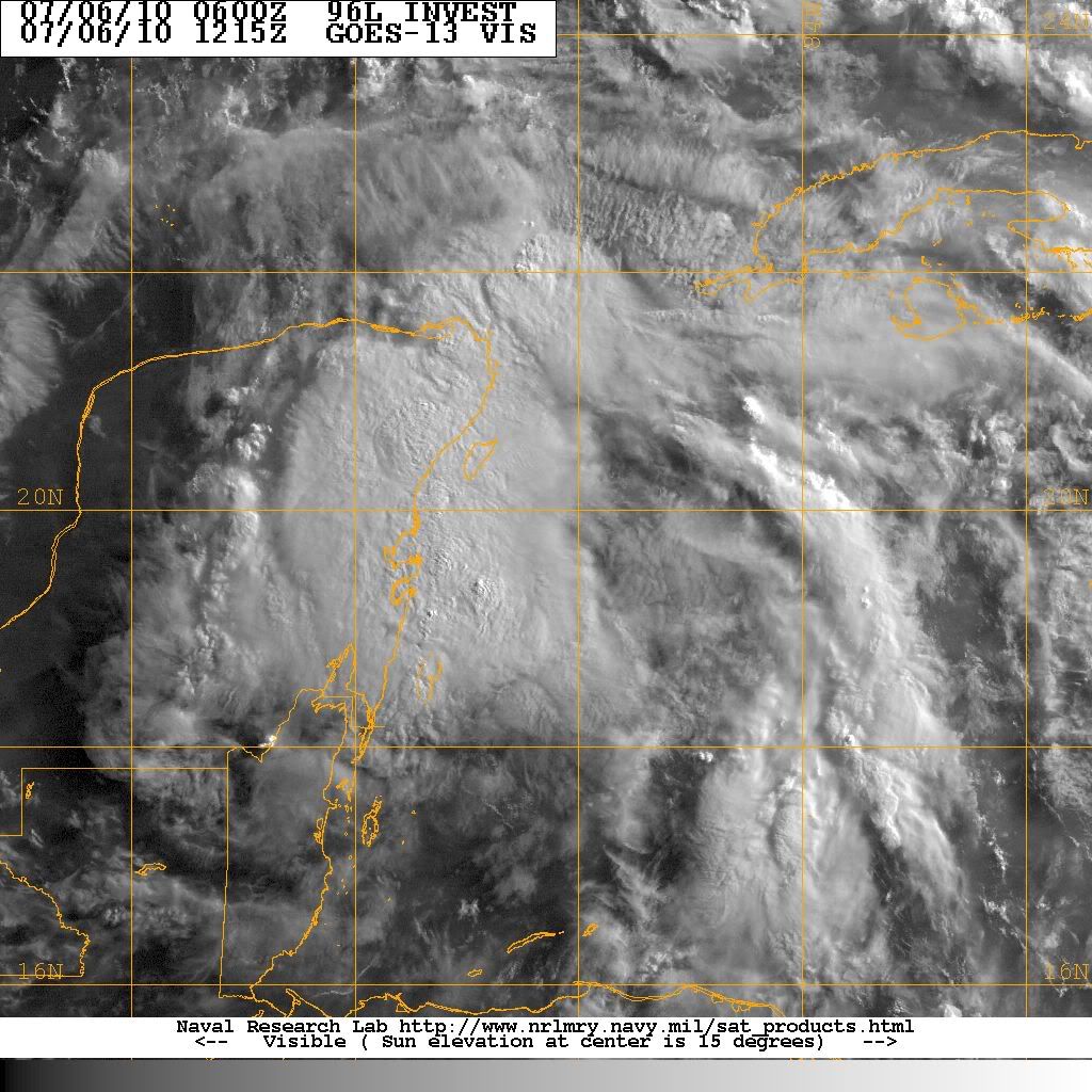
96L is totally disorganized this morning. I believe the concentration of convection over the Yucatan is an mid level circulation just like a couple of days ago. I see a definitive low level cyclonic rotation in the low cloud field over the south central Gulf of Mexico well north of the Yucatan. If you can go to this link: http://wwwghcc.msfc.nasa.gov/GOES/ which is the Interactive satellite site go to the 1km visible imagery and look near 24N and 89W. If you use animation you will clearly see the surface low in the central Gulf void of deep convection. All I can find is SE winds and rising pressure over the Yucatan now. I personally believe IF a surface circulation were to form it would have to be over the central Gulf. It's as if the energy is being pulled rapidly northward towards 95L and what is being tracked near Cancun is another mid level circulation just like the one that formed on July 4th. Does anyone else see this also?
0 likes
Re:
HouTXmetro wrote:Doesn't look organized but impressive convection this AM. and the Convection has been persistent in one area which leads me ti believe something was trying to work it's way down.
Possibly but it does look like its really struggled to work anything down, afterall its had the MLC for some time now.
0 likes
Personal Forecast Disclaimer:
The posts in this forum are NOT official forecast and should not be used as such. They are just the opinion of the poster and may or may not be backed by sound meteorological data. They are NOT endorsed by any professional institution or storm2k.org. For official information, please refer to the NHC and NWS products
The posts in this forum are NOT official forecast and should not be used as such. They are just the opinion of the poster and may or may not be backed by sound meteorological data. They are NOT endorsed by any professional institution or storm2k.org. For official information, please refer to the NHC and NWS products
-
Dean4Storms
- S2K Supporter
- Posts: 6358
- Age: 63
- Joined: Sun Aug 31, 2003 1:01 pm
- Location: Miramar Bch. FL
Re:
djones65 wrote:96L is totally disorganized this morning. I believe the concentration of convection over the Yucatan is an mid level circulation just like a couple of days ago. I see a definitive low level cyclonic rotation in the low cloud field over the south central Gulf of Mexico well north of the Yucatan. If you can go to this link: http://wwwghcc.msfc.nasa.gov/GOES/ which is the Interactive satellite site go to the 1km visible imagery and look near 24N and 89W. If you use animation you will clearly see the surface low in the central Gulf void of deep convection. All I can find is SE winds and rising pressure over the Yucatan now. I personally believe IF a surface circulation were to form it would have to be over the central Gulf. It's as if the energy is being pulled rapidly northward towards 95L and what is being tracked near Cancun is another mid level circulation just like the one that formed on July 4th. Does anyone else see this also?
Yes and I talked about this early yesterday, the area of lowest pressure with some low level turning was off the NE tip of the Yucatan yesterday afternoon and the night before passed over the Buoy in the Yucatan pass which clearly showed this lows passage. It was moving rapidly NNW.
I think the convection is the western Carib. however did form a secondary low and that is what they came along and tagged as 96L yesterday. I guess you can switch the Invest to different lows.
0 likes
-
ConvergenceZone
.gif)
- Category 5
- Posts: 5241
- Joined: Fri Jul 29, 2005 1:40 am
- Location: Northern California
Re: ATL: INVEST 96L - DISCUSSION
johngaltfla wrote:I honestly think that if it doesn't develop and just stays an open wave, you won't hear any hearts breaking in the GOM. We really need the Gulf to remain storm free until the relief wells are finished and cap that disaster.
Amen! My thoughts exactly. I love watching storms develop, but the oil spill makes me sad and thinking of a storm making it worse makes me even sadder.
0 likes

Re:
djones65 wrote:96L is totally disorganized this morning. I believe the concentration of convection over the Yucatan is an mid level circulation just like a couple of days ago. I see a definitive low level cyclonic rotation in the low cloud field over the south central Gulf of Mexico well north of the Yucatan. If you can go to this link: http://wwwghcc.msfc.nasa.gov/GOES/ which is the Interactive satellite site go to the 1km visible imagery and look near 24N and 89W. If you use animation you will clearly see the surface low in the central Gulf void of deep convection. All I can find is SE winds and rising pressure over the Yucatan now. I personally believe IF a surface circulation were to form it would have to be over the central Gulf. It's as if the energy is being pulled rapidly northward towards 95L and what is being tracked near Cancun is another mid level circulation just like the one that formed on July 4th. Does anyone else see this also?
I see what you mean at 24N/89W. 850mb vorticity in this area is high. Pressure is rising, though, 1016/1014 in the area. Not much convection on visible. Shear has let up in the past 3 hours in the immediate vicinity. Looks like 95L remnants sucking the water vapour from 96L, replacing the drier air in the gulf.
Last edited by TYNI on Tue Jul 06, 2010 9:44 am, edited 1 time in total.
0 likes
Personal Forecast Disclaimer:
The posts in this forum are NOT official forecast and should not be used as such. They are just the opinion of the poster and may or may not be backed by sound meteorological data. They are NOT endorsed by any professional institution or storm2k.org. For official information, please refer to the NHC and NWS products.
The posts in this forum are NOT official forecast and should not be used as such. They are just the opinion of the poster and may or may not be backed by sound meteorological data. They are NOT endorsed by any professional institution or storm2k.org. For official information, please refer to the NHC and NWS products.
Regardless of what 96L does in terms of development it looks like it'll be a very rainy set-up if it brings up as much moisture as it currently has.
0 likes
Personal Forecast Disclaimer:
The posts in this forum are NOT official forecast and should not be used as such. They are just the opinion of the poster and may or may not be backed by sound meteorological data. They are NOT endorsed by any professional institution or storm2k.org. For official information, please refer to the NHC and NWS products
The posts in this forum are NOT official forecast and should not be used as such. They are just the opinion of the poster and may or may not be backed by sound meteorological data. They are NOT endorsed by any professional institution or storm2k.org. For official information, please refer to the NHC and NWS products


Re: ATL: INVEST 96L - DISCUSSION
Personal Forecast Disclaimer:
The posts in this forum are NOT official forecast and should not be used as such. They are just the opinion of the poster and may or may not be backed by sound meteorological data. They are NOT endorsed by any professional institution or storm2k.org. For official information, please refer to the NHC and NWS products.
If we interpolate Alex directly 96L should develop into a hurricane before shore wherever it landfalls in the Gulf.
The convection behavior is definitely persistence with a consolidating central convection area. Alex did this as well before it developed into a cyclone.
96L will hit a cool water pocket off Yucatan so the rebound should be delayed.
.
0 likes
Who is online
Users browsing this forum: No registered users and 65 guests