ENSO Updates (2007 thru 2023)
Moderator: S2k Moderators
Forum rules

The posts in this forum are NOT official forecasts and should not be used as such. They are just the opinion of the poster and may or may not be backed by sound meteorological data. They are NOT endorsed by any professional institution or STORM2K. For official information, please refer to products from the National Hurricane Center and National Weather Service.


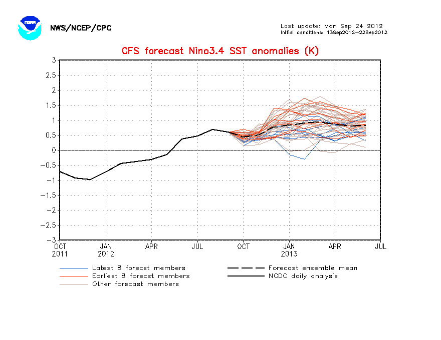
Hmm interesting though the immediate subsurface below ENSO 3. has actually eased off a little...
0 likes
Personal Forecast Disclaimer:
The posts in this forum are NOT official forecast and should not be used as such. They are just the opinion of the poster and may or may not be backed by sound meteorological data. They are NOT endorsed by any professional institution or storm2k.org. For official information, please refer to the NHC and NWS products
The posts in this forum are NOT official forecast and should not be used as such. They are just the opinion of the poster and may or may not be backed by sound meteorological data. They are NOT endorsed by any professional institution or storm2k.org. For official information, please refer to the NHC and NWS products

Re: ENSO=Read Dr Jeff Masters discussion (La Nina by July?)
According to this chart, if I’m understanding it correctly, there are generally more cyclones in neutral years than in La Niña years. That’s interesting.cycloneye wrote:I found an error in the El Nino years list by Dr Master's post as 2002 was in an El Nino year and not 2001 that was Neutral.
0 likes
-
cycloneye

- Admin

- Posts: 149505
- Age: 69
- Joined: Thu Oct 10, 2002 10:54 am
- Location: San Juan, Puerto Rico
Re: ENSO Updates
Yes abajan,the trend is for more tropical activity with Neutral ENSO.But the real favorable conditions for the Atlantic is to have La Nina as the windshear goes down bigtime.Also,the tracks when it is Neutral tends to be fish for the most part,while in La Nina,they go more west.
0 likes
Visit the Caribbean-Central America Weather Thread where you can find at first post web cams,radars
and observations from Caribbean basin members Click Here
and observations from Caribbean basin members Click Here
-
cycloneye
- Admin
- Posts: 149505
- Age: 69
- Joined: Thu Oct 10, 2002 10:54 am
- Location: San Juan, Puerto Rico
Re: ENSO Updates=CPC 6/28/10=Nino 3.4 at -0.5 / Nino 3 at -0.7
Climate Prediction Center 6/28/10 weekly update
Nino 3.4 mantains at the number of threshold of La Nina -0.5 and Nino 3 is at -0.7,a sign that the official proclamation is comming in the next 2-3 weeks.
Last Week Numbers
Niño 4= 0.0ºC
Niño 3.4= -0.5ºC
Niño 3= -0.6ºC
Niño1+2= -0.7ºC
This Week Numbers
Niño 4= -0.1ºC
Niño 3.4= -0.5ºC
Niño 3= -0.7ºC
Niño1+2= -0.3ºC
http://www.cpc.ncep.noaa.gov/products/a ... ts-web.pdf
0 likes
Visit the Caribbean-Central America Weather Thread where you can find at first post web cams,radars
and observations from Caribbean basin members Click Here
and observations from Caribbean basin members Click Here
-
cycloneye
- Admin
- Posts: 149505
- Age: 69
- Joined: Thu Oct 10, 2002 10:54 am
- Location: San Juan, Puerto Rico
Re: ENSO Updates
La Nina is here.Is only a matter to make it official by Climate Prediction Center. IMO,next week's monthly update may be the time to pull the trigger.

0 likes
Visit the Caribbean-Central America Weather Thread where you can find at first post web cams,radars
and observations from Caribbean basin members Click Here
and observations from Caribbean basin members Click Here
-
cycloneye
- Admin
- Posts: 149505
- Age: 69
- Joined: Thu Oct 10, 2002 10:54 am
- Location: San Juan, Puerto Rico
Re: ENSO Updates
The CFS (NCEP) model now is forecasting a Moderate to Strong La Nina by the peak of the season (ASO)
http://www.cpc.ncep.noaa.gov/products/a ... cast.shtml
http://www.cpc.ncep.noaa.gov/products/a ... cast.shtml
0 likes
Visit the Caribbean-Central America Weather Thread where you can find at first post web cams,radars
and observations from Caribbean basin members Click Here
and observations from Caribbean basin members Click Here
-
cycloneye
- Admin
- Posts: 149505
- Age: 69
- Joined: Thu Oct 10, 2002 10:54 am
- Location: San Juan, Puerto Rico
Re: ENSO=CPC 7/6/10=Nino 3.4 down to -0.6 / Nino 3 down to -0.7
Climate Prediction Center 7/6/10 Weekly Update
Nino 3.4 continues to go down now at -0.6C at Weak La Nina threashold. I guess CPC will declare officially La Nina if not in next thursday's montly update, then in the August one.
Last Week Numbers
Niño 4= -0.1ºC
Niño 3.4= -0.5ºC
Niño 3= -0.7ºC
Niño1+2= -0.3ºC
This Week Numbers
Niño 4= -0.2ºC
Niño 3.4= -0.6ºC
Niño 3= -0.7ºC
Niño1+2= -0.9ºC
http://www.cpc.ncep.noaa.gov/products/a ... ts-web.pdf
0 likes
Visit the Caribbean-Central America Weather Thread where you can find at first post web cams,radars
and observations from Caribbean basin members Click Here
and observations from Caribbean basin members Click Here
-
cycloneye
- Admin
- Posts: 149505
- Age: 69
- Joined: Thu Oct 10, 2002 10:54 am
- Location: San Juan, Puerto Rico
Re: ENSO=CPC 7/6/10=Nino 3.4 down to -0.6 / Nino 3 down to -0.7
The POAMA model (Australian) continues to forecast Weak to Moderate La Nina thru the end of this year.

0 likes
Visit the Caribbean-Central America Weather Thread where you can find at first post web cams,radars
and observations from Caribbean basin members Click Here
and observations from Caribbean basin members Click Here
Hmmm so we are now in 1995 region with regards to the strength of the La Nina. I'm hoping the La Nina strengthens further because where it is at now is perfect for a huge season IMO.
0 likes
Personal Forecast Disclaimer:
The posts in this forum are NOT official forecast and should not be used as such. They are just the opinion of the poster and may or may not be backed by sound meteorological data. They are NOT endorsed by any professional institution or storm2k.org. For official information, please refer to the NHC and NWS products
The posts in this forum are NOT official forecast and should not be used as such. They are just the opinion of the poster and may or may not be backed by sound meteorological data. They are NOT endorsed by any professional institution or storm2k.org. For official information, please refer to the NHC and NWS products
-
bvigal

- S2K Supporter

- Posts: 2276
- Joined: Sun Jul 24, 2005 8:49 am
- Location: British Virgin Islands
- Contact:
Re: ENSO=CPC 7/6/10=Nino 3.4 down to -0.6 / Nino 3 down to -0.7
KWT wrote:Hmmm so we are now in 1995 region with regards to the strength of the La Nina. I'm hoping the La Nina strengthens further because where it is at now is perfect for a huge season IMO.
So KWT, you are hoping it gets stronger, in order to result in LESS storms? I'm 'hoping' that's what you mean!
0 likes
-
cycloneye
- Admin
- Posts: 149505
- Age: 69
- Joined: Thu Oct 10, 2002 10:54 am
- Location: San Juan, Puerto Rico
Re: ENSO=CPC 7/6/10=Nino 3.4 down to -0.6 / Nino 3 down to -0.7
bvigal,what KWT may be referring to is about La Nina causing somewhat less activity in the Atlantic believe it or not.Look at the chart below.

0 likes
Visit the Caribbean-Central America Weather Thread where you can find at first post web cams,radars
and observations from Caribbean basin members Click Here
and observations from Caribbean basin members Click Here
Yeah typically stronger La Nina's don't have quite the same number of systems have neutral or weak La Nina's...
That being said it may all be a moot point given the La Nina is taking its time, probably won't be beyond a mid-weak La Nina in ASO...
That being said it may all be a moot point given the La Nina is taking its time, probably won't be beyond a mid-weak La Nina in ASO...
0 likes
Personal Forecast Disclaimer:
The posts in this forum are NOT official forecast and should not be used as such. They are just the opinion of the poster and may or may not be backed by sound meteorological data. They are NOT endorsed by any professional institution or storm2k.org. For official information, please refer to the NHC and NWS products
The posts in this forum are NOT official forecast and should not be used as such. They are just the opinion of the poster and may or may not be backed by sound meteorological data. They are NOT endorsed by any professional institution or storm2k.org. For official information, please refer to the NHC and NWS products
-
bvigal
- S2K Supporter
- Posts: 2276
- Joined: Sun Jul 24, 2005 8:49 am
- Location: British Virgin Islands
- Contact:
Re: ENSO=CPC 7/6/10=Nino 3.4 down to -0.6 / Nino 3 down to -0.7
Thanks, guys!
After I read it more slowly the second time, I was pretty sure that's what KWT's comment meant. I only wanted to clarify, in case anyone else had my first impression.
Yes, Luis, I had seen the chart posted earlier - very interesting!! And, your comment was right, "Also,the tracks when it is Neutral tends to be fish for the most part,while in La Nina,they go more west." So maybe we should root for the weakest La Nina possible.
I know, lots of storm 'fans' here love it wild and crazy, and it IS an adrenalin rush. But, my enthusiam wanes more with each passing year of reality - watching carefully, yet praying for a healthy serving of "fish and poofs"!!!
0 likes
-
thetruesms

- Professional-Met

- Posts: 844
- Age: 42
- Joined: Thu Aug 16, 2007 1:14 pm
- Location: Tallahasee, FL
- Contact:
Re: ENSO=CPC 7/6/10=Nino 3.4 down to -0.6 / Nino 3 down to -0.7
I dislike this image, because it implies that La Nina seasons are inherently less active than Neutral seasons, when there doesn't appear to be any statistical significance to that claim at all. Toss out the outlier 2005 season, and suddenly Neutral and La Nina seasons are much closer together.cycloneye wrote:bvigal,what KWT may be referring to is about La Nina causing somewhat less activity in the Atlantic believe it or not.Look at the chart below.
[img]http://www.wunderground.com/hurricane/2010/since1995_dean.jpg[img]
If someone with statistical software feels like throwing the numbers in, or perhaps if I get some time to do the calculations manually, I can investigate the validity a little more rigorously. But with so little data in these sets, I'm not sure how much there is to be gleaned from it.
0 likes
Usually the reason why La Nina's have a little lower numbers, esp moderate La Nina's in the ASO time, is because they tend to have slow starts. In many ways both 1998 and 1999 were perfect examples of that occuring. 2007 however actually was a weak La Nina in ASO and only really got going in the late Autumn.
The meat of the season tend to be a little busier in La Nina seasons though and the latter tends to be a little more active as well.
The meat of the season tend to be a little busier in La Nina seasons though and the latter tends to be a little more active as well.
0 likes
Personal Forecast Disclaimer:
The posts in this forum are NOT official forecast and should not be used as such. They are just the opinion of the poster and may or may not be backed by sound meteorological data. They are NOT endorsed by any professional institution or storm2k.org. For official information, please refer to the NHC and NWS products
The posts in this forum are NOT official forecast and should not be used as such. They are just the opinion of the poster and may or may not be backed by sound meteorological data. They are NOT endorsed by any professional institution or storm2k.org. For official information, please refer to the NHC and NWS products
-
cycloneye
- Admin
- Posts: 149505
- Age: 69
- Joined: Thu Oct 10, 2002 10:54 am
- Location: San Juan, Puerto Rico
Re: ENSO Updates=CPC 7/8/10 Monthly update=La Nina by July-Aug
Climate Prediction Center 7/8/10 Monthly Update
Below is the July update by CPC where they say La Nina will be officially declared later in July or in August.
http://www.cpc.ncep.noaa.gov/products/a ... odisc.html
Below is the July update by CPC where they say La Nina will be officially declared later in July or in August.
http://www.cpc.ncep.noaa.gov/products/a ... odisc.html
Synopsis: La Niña conditions are likely to develop during July - August 2010.
During June 2010, sea surface temperature (SST) anomalies continued to decrease across the equatorial Pacific Ocean, with negative anomalies expanding across the central and eastern Pacific (Fig. 1). While the rate of decrease slowed during June, all of the Niño indices were cooler compared to the previous month (Fig. 2). The subsurface heat content (average temperatures in the upper 300m of the ocean, Fig. 3) also remained below-average during the month. Subsurface temperature anomalies became increasingly negative in the east-central equatorial Pacific and extended to the surface across the eastern half of the basin (Fig. 4). Also during June, enhanced convection persisted over Indonesia, while the area of suppressed convection strengthened and expanded westward over the western and central equatorial Pacific (Fig. 5). Enhanced low-level easterly trade winds and anomalous upper-level westerly winds prevailed over the western and central equatorial Pacific. Collectively, these oceanic and atmospheric anomalies reflect developing La Niña conditions. .
The majority of models now predict La Niña conditions (SST anomalies less than or equal to -0.5oC in the Niño-3.4 region) to develop during June-August and to continue through early 2011 (Fig. 6). Confidence in this outcome is reinforced by the recent performance of the NCEP Climate Forecast System (CFS) (Fig. 7), the large reservoir of colder-than-average subsurface water (Fig. 3), and signs of coupling with the atmospheric circulation. Therefore, La Niña conditions are likely to develop during July-August 2010.
0 likes
Visit the Caribbean-Central America Weather Thread where you can find at first post web cams,radars
and observations from Caribbean basin members Click Here
and observations from Caribbean basin members Click Here
-
cycloneye
- Admin
- Posts: 149505
- Age: 69
- Joined: Thu Oct 10, 2002 10:54 am
- Location: San Juan, Puerto Rico
Re: ENSO Updates=CPC 7/8/10 Monthly update=La Nina by July-Aug
0 likes
Visit the Caribbean-Central America Weather Thread where you can find at first post web cams,radars
and observations from Caribbean basin members Click Here
and observations from Caribbean basin members Click Here
I think the idea that it means more hurricanes is almost the same now as the whole idea of the QBO role used to be like, whilst it can have an impact, the difference in La Nina and neutral in a warm AMO tends to be more in the realm of steering currents rather then just 'more hurricanes, indeed as the stats show, there tends to be slightly less in terms of numbers in La Nina's then in neutral seasons during the most recent AMO cycle at least...I'm guessing La Nina's become more important in cold AMO cycles...
No doubt the best ENSO evolution is a warm phase winter, then weakening to neutral/weak La Nina for the summer...most of the big seasons in history have had that sort of profile....and thats what we have this year...
No doubt the best ENSO evolution is a warm phase winter, then weakening to neutral/weak La Nina for the summer...most of the big seasons in history have had that sort of profile....and thats what we have this year...
0 likes
Personal Forecast Disclaimer:
The posts in this forum are NOT official forecast and should not be used as such. They are just the opinion of the poster and may or may not be backed by sound meteorological data. They are NOT endorsed by any professional institution or storm2k.org. For official information, please refer to the NHC and NWS products
The posts in this forum are NOT official forecast and should not be used as such. They are just the opinion of the poster and may or may not be backed by sound meteorological data. They are NOT endorsed by any professional institution or storm2k.org. For official information, please refer to the NHC and NWS products
-
frederic79

- Category 1

- Posts: 271
- Joined: Sun Jul 18, 2004 8:48 pm
- Location: Grand Bay, AL
AP article: La Nina conditions developing
Someone may of already posted this but here is the link to an AP article just released regarding the return of La Nina and its expected effect on the 2010 hurricane season.
http://www.google.com/hostednews/ap/art ... wD9GQVAP04
http://www.google.com/hostednews/ap/art ... wD9GQVAP04
0 likes
-
cycloneye
- Admin
- Posts: 149505
- Age: 69
- Joined: Thu Oct 10, 2002 10:54 am
- Location: San Juan, Puerto Rico
Re: ENSO Updates
One more signal that La Nina is here,is the SOI index that continues strongly in positive territory. The holdout for declaring ENSO officially in La Nina status is Climate Prediction Center, but as I posted last week, they said in the last bulletin La Nina will be declared by late July or in August. The pending question is how strong this La Nina will be,but some ENSO models are very bullish on a moderate to strong La Nina.
Daily SOI Values
http://www.longpaddock.qld.gov.au/seaso ... /index.php
Daily 30 day SOI Text
http://www.bom.gov.au/climate/enso/soi.txt

Daily SOI Values
http://www.longpaddock.qld.gov.au/seaso ... /index.php
Daily 30 day SOI Text
http://www.bom.gov.au/climate/enso/soi.txt
0 likes
Visit the Caribbean-Central America Weather Thread where you can find at first post web cams,radars
and observations from Caribbean basin members Click Here
and observations from Caribbean basin members Click Here
Who is online
Users browsing this forum: Iceresistance, Kingarabian and 342 guests