ATL: TROPICAL DEPRESSION TWO - DISCUSSION
Moderator: S2k Moderators
-
TwisterFanatic

- Category 5

- Posts: 1041
- Joined: Mon Jun 28, 2010 12:43 pm
- Location: Sallisaw, Oklahoma
Re: ATL: INVEST 96L - DISCUSSION
Just checking in.. How is this thing doing today is it still pathetic looking?
0 likes
Personal Forecast Disclaimer:
The posts in this forum are NOT official forecast and should not be used as such. They are just the opinion of the poster and may or may not be backed by sound meteorological data. They are NOT endorsed by any professional institution or storm2k.org. For official information, please refer to the NHC and NWS products.
The posts in this forum are NOT official forecast and should not be used as such. They are just the opinion of the poster and may or may not be backed by sound meteorological data. They are NOT endorsed by any professional institution or storm2k.org. For official information, please refer to the NHC and NWS products.


-
HURAKAN

- Professional-Met

- Posts: 46084
- Age: 39
- Joined: Thu May 20, 2004 4:34 pm
- Location: Key West, FL
- Contact:
WTNT01 KNGU 072000
SUBJ/TROPICAL CYCLONE FORMATION ALERT 072000Z JUL 10//
RMKS/1. FORMATION OF A SIGNIFICANT TROPICAL CYCLONE IS POSSIBLE WITHIN
100 NM EITHER SIDE OF A LINE FROM 23.8N 93.6W TO 26.1N 98.8W
WITHIN THE NEXT 12 TO 24 HOURS. AVAILABLE DATA DOES NOT JUSTIFY
ISSUANCE OF NUMBERED TROPICAL CYCLONE WARNING AT THIS TIME.
WINDS IN THE AREA ARE ESTIMATED TO BE 20 TO 25 KNOTS. METSAT
IMAGERY AT 071930Z INDICATES THAT A CIRCULATION CENTER IS LOCATED
NEAR 23.8N 93.6W. THE SYSTEM IS MOVING WEST-NORTHWESTWARD AT 13
KNOTS.
2. REMARKS: A BROAD AREA OF LOW PRESSURE LOCATED JUST WEST OF THE
YUCATAN PENINSULA TRACKS WEST-NORTHWEST TOWARDS THE NORTHEAST COAST
OF MEXICO. THE LATEST METSAT IMAGERY INDICATES INCREASED CONVECTION,
WHICH IS INDICATIVE OF STRENGTHENING. INCREASED SEA SURFACE TEMPERATURES
IN THE REGION AND LIGHT UPPER LEVEL WIND SHEAR WILL PROVIDE FAVORABLE
CONDITIONS FOR TROPICAL CYCLONE DEVELOPMENT.
3. THIS ALERT WILL BE REISSUED, UPGRADED TO WARNING OR CANCELLED
BY 082000Z.//
0 likes
-
RachelAnna

- Tropical Storm

- Posts: 106
- Joined: Mon Jun 28, 2010 10:38 pm
- Location: Cypress, Texas
Re: ATL: INVEST 96L - DISCUSSION
hriverajr wrote:Not the greatest of convection. But visible shows it continuing to get better organized. I would be surprised if this was not upgraded soon. Still looks to be moving just a tad north of west northwest.
Think it'll continue the nnw movement long? If so, do you think we are going to see any big changes in models?
0 likes
-
chzzdekr81

- S2K Supporter

- Posts: 189
- Joined: Sun Aug 30, 2009 7:54 pm
- Location: Orange, Texas (SETX)
- Contact:

-
JonathanBelles
- Professional-Met
- Posts: 11430
- Age: 35
- Joined: Sat Dec 24, 2005 9:00 pm
- Location: School: Florida State University (Tallahassee, FL) Home: St. Petersburg, Florida
- Contact:
Re: ATL: INVEST 96L - DISCUSSION
Ivanhater wrote:TCFA issued
When you post items like this, can you please explain them for the newer members coming aboard? Thanks!
0 likes
-
Wx_Warrior
- Category 5
- Posts: 2718
- Joined: Thu Aug 03, 2006 3:58 pm
- Location: Beaumont, TX

Re:
HURAKAN wrote:Looking good in the loop
May be a trick of the eyes but in the last few frames it looks like the turning, which was visible at the whole time at the low levels, becomes increasingly visible in the higher convection above the low level spin.
0 likes
-
Ivanhater

- Storm2k Moderator

- Posts: 11221
- Age: 39
- Joined: Fri Jul 01, 2005 8:25 am
- Location: Pensacola
Re: ATL: INVEST 96L - DISCUSSION
Yeah Jonathan...Hurakan posted the text with it below my post..pretty much explains it.
Basically when the Tropical Cyclone Formation Alert (TCFA) is issued, it usually mean an upgrade is around the corner, not always though
Basically when the Tropical Cyclone Formation Alert (TCFA) is issued, it usually mean an upgrade is around the corner, not always though
0 likes
Michael
-
southerngale

- Retired Staff

- Posts: 27418
- Joined: Thu Oct 10, 2002 1:27 am
- Location: Southeast Texas (Beaumont area)
Parts of the Beaumont area (in Hardin and Jefferson counties) had already received 3 - 5 inches of rain just by 11am this morning, from the morning storms, and it's rained a lot after that. That's on top of already very saturated grounds. It looks like with 96L heading toward Deep South Texas or NE MX (or whatever it will be called by landfall) will bring even more rain up here, along with much of Texas. Hopefully, if anyone still needs rain, they'll be the ones to get most of it.
96L looks a LOT better than it did a mere 12 hours ago!
96L looks a LOT better than it did a mere 12 hours ago!
0 likes
Please support Storm2k by making a donation today. It is greatly appreciated! Click here: 
 my Cowboys my Rockets my Astros
my Cowboys my Rockets my Astros-
Air Force Met
- Military Met

- Posts: 4372
- Age: 57
- Joined: Tue Jul 08, 2003 9:30 am
- Location: Roan Mountain, TN
Re: Re:
BigA wrote:HURAKAN wrote:Looking good in the loop
May be a trick of the eyes but in the last few frames it looks like the turning, which was visible at the whole time at the low levels, becomes increasingly visible in the higher convection above the low level spin.
You are correct. I made mention of this to a friend of mine an hour or so ago (over the phone). Its the mid level vorticity beginning to spin up...which means that 96L is trying to get some sort of stacking together.
0 likes
-
Hurricane Andrew

- S2K Supporter
- Posts: 1891
- Age: 27
- Joined: Sun May 23, 2010 2:53 pm
- Location: KS
I am a touch worried for C texas. They have already had alot of rain, and now they are gonna have more. WOW> Poor texas...everything's always bigger in Texas. i guess that goes for Floods too.
0 likes
The Enthusiast
NREMT-AEMT, WX nerd
Irene '11, Sandy '12, Irma '17 (SAR)
"Hard to think we were born to live this way..." -Wage War
-
Over my head

- Tropical Depression

- Posts: 86
- Joined: Sat Aug 18, 2007 7:52 pm
- Location: Southeast Texas
Re: ATL: INVEST 96L - DISCUSSION
Air Force Met wrote:hello, subjectivitythetruesms wrote:
LOL

Exactly. What Avila thinks is organized and well defined is not what Stewart thinks is organized or well defined.
Avila is a storm killer...doesn't like to intensify them...think of him as "Round Up" for hurricanes...
Stewart is a storm builder...loves to name them and strengthen them...think of him as "Miracle Grow" for hurricanes...
Thanks AFMet ! I understood that perfectly.
Last edited by Over my head on Wed Jul 07, 2010 4:28 pm, edited 1 time in total.
0 likes
-
wxman57

- Moderator-Pro Met

- Posts: 23175
- Age: 68
- Joined: Sat Jun 21, 2003 8:06 pm
- Location: Houston, TX (southwest)
Re: ATL: INVEST 96L - DISCUSSION
Still looks quite pathetic to me. It's lacking a well-defined LLC and has no "organized" convection. Convective tops are warming near the weak low pressure area. I don't see anything to warrant an upgrade. Doesn't qualify as a TD in my opinion. That puts me in the Avila camp. Now if we see a big burst of heavy convection over that weak LLC tonight, then that would help to tighten up the circulation and would warrant an upgrade. But I think that's unlikely given the general lack of surface convergence near the low.
Besides, I win a free lunch tomorrow if NHC doesn't upgrade before 00Z tonight.

Besides, I win a free lunch tomorrow if NHC doesn't upgrade before 00Z tonight.
0 likes

Re: ATL: INVEST 96L - DISCUSSION
I think someone may be blinded by a free lunch. I think it is a TD already.
0 likes
-
Tireman4

- S2K Supporter
- Posts: 5903
- Age: 60
- Joined: Fri Jun 30, 2006 1:08 pm
- Location: Humble, Texas
- Contact:
Re: ATL: INVEST 96L - DISCUSSION
Besides, I win a free lunch tomorrow if NHC doesn't upgrade before 00Z tonight.
What kind of lunch? Luby's? LOL
What kind of lunch? Luby's? LOL
0 likes
-
Ikester
- Professional-Met
- Posts: 361
- Age: 40
- Joined: Mon Jun 21, 2010 5:00 pm
- Location: Jacksonville, FL
Re:
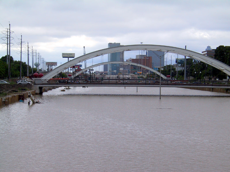
Hurricane Andrew wrote:I am a touch worried for C texas. They have already had alot of rain, and now they are gonna have more. WOW> Poor texas...everything's always bigger in Texas. i guess that goes for Floods too.
You can say that again! Here's pics from Allison...

BTW, the below pic is 59, southwest frwy near Greenway Plaza. The water here would easily be 20' deep. It is a sunken freeway--literally.
0 likes
Who is online
Users browsing this forum: No registered users and 23 guests