ATL: TROPICAL DEPRESSION TWO - DISCUSSION
Moderator: S2k Moderators
-
Stormcenter
- S2K Supporter

- Posts: 6689
- Joined: Wed Sep 03, 2003 11:27 am
- Location: Houston, TX
-
Tireman4

- S2K Supporter
- Posts: 5903
- Age: 60
- Joined: Fri Jun 30, 2006 1:08 pm
- Location: Humble, Texas
- Contact:
Re: Re:
Ikester wrote:Hurricane Andrew wrote:I am a touch worried for C texas. They have already had alot of rain, and now they are gonna have more. WOW> Poor texas...everything's always bigger in Texas. i guess that goes for Floods too.
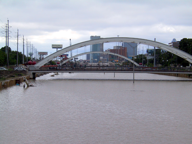
You can say that again! Here's pics from Allison...
BTW, the below pic is 59, southwest frwy near Greenway Plaza. The water here would easily be 20' deep. It is a sunken freeway--literally.

I was in the Alief area of Houston and barely got anything. It was wild. I was working at Firestone at the time and we had to shut down early (4pm) as opposed to 6 pm because all of the main computers went down.
0 likes
-
hurricaneCW
- Category 5

- Posts: 1799
- Joined: Wed Mar 03, 2010 6:20 am
- Location: Toms River, NJ
Re: ATL: INVEST 96L - DISCUSSION
It definitely doesn't look like a developing system, in my opinion. Warm cloud tops, rather disorganized convection. Maybe it'll become one of those last minute weak tropical storms (40mph) due to its proximity to land. Regardless, more rain for an already flooded region can't be good. Looks like we might be done for a while after 96L. Check out the massive plume of dry air off of Africa, killing off any waves that decide to come off the coast.
http://cimss.ssec.wisc.edu/tropic/real- ... split.html
http://cimss.ssec.wisc.edu/tropic/real- ... split.html
0 likes
-
lrak

- S2K Supporter
- Posts: 1770
- Age: 59
- Joined: Thu Jun 21, 2007 2:48 pm
- Location: Corpus Christi, TX
Re: ATL: INVEST 96L - DISCUSSION
wxman57 it looks like your crosshairs on the map should be move abit SE?
0 likes
AKA karl
Also
Personal Forecast Disclaimer:
My posts on this forum are NOT official forecast and should not be used as such. My posts are my basic observations and are definitely not backed by any "well some" meteorological knowledge. For official information, please refer to the NHC and NWS products.
Also
Personal Forecast Disclaimer:
My posts on this forum are NOT official forecast and should not be used as such. My posts are my basic observations and are definitely not backed by any "well some" meteorological knowledge. For official information, please refer to the NHC and NWS products.
-
RachelAnna

- Tropical Storm

- Posts: 106
- Joined: Mon Jun 28, 2010 10:38 pm
- Location: Cypress, Texas
Re: ATL: INVEST 96L - DISCUSSION
Not to mention since Alex a lot of the area has been getting rain everyday...so we haven't really had a chance to dry out. It's raining at my house right now in Cypress...
0 likes
-
Ikester
- Professional-Met

- Posts: 361
- Age: 40
- Joined: Mon Jun 21, 2010 5:00 pm
- Location: Jacksonville, FL
Re: ATL: INVEST 96L - DISCUSSION
Like I said in the recon discussion topic, the only difference here is going to be nomenclature if I had to guess (barring any rapid development). Tropical Depression, weak storm or just a vigorous wave will all produce the same effects. As you can see above, Allison was a tropical storm but that is not why she was remembered or retired for that matter.
0 likes
-
ozonepete
- Professional-Met
- Posts: 4743
- Joined: Mon Sep 07, 2009 3:23 pm
- Location: From Ozone Park, NYC / Now in Brooklyn, NY
Re: ATL: INVEST 96L - DISCUSSION
wx88 wrote:I think someone may be blinded by a free lunch. I think it is a TD already.
Yeah, wxman57. Looks like your lunch will be crow.
0 likes


-
lrak
- S2K Supporter
- Posts: 1770
- Age: 59
- Joined: Thu Jun 21, 2007 2:48 pm
- Location: Corpus Christi, TX
Re: ATL: INVEST 96L - DISCUSSION
0 likes
AKA karl
Also
Personal Forecast Disclaimer:
My posts on this forum are NOT official forecast and should not be used as such. My posts are my basic observations and are definitely not backed by any "well some" meteorological knowledge. For official information, please refer to the NHC and NWS products.
Also
Personal Forecast Disclaimer:
My posts on this forum are NOT official forecast and should not be used as such. My posts are my basic observations and are definitely not backed by any "well some" meteorological knowledge. For official information, please refer to the NHC and NWS products.
-
Air Force Met
- Military Met

- Posts: 4372
- Age: 57
- Joined: Tue Jul 08, 2003 9:30 am
- Location: Roan Mountain, TN
Re: ATL: INVEST 96L - DISCUSSION
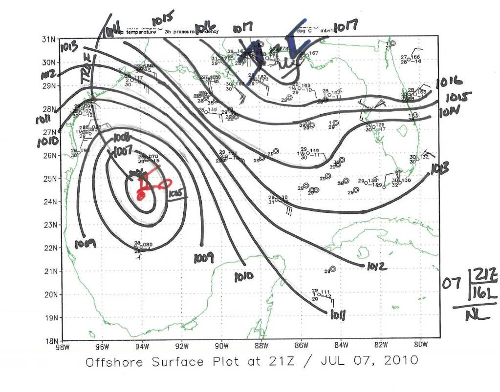
I've analyzed a 21Z sfc map of the Gulf and posted it. Gives an idea of what we are seeing at the sfc...
0 likes
Re: ATL: INVEST 96L - DISCUSSION
MGC wrote:The visable satellite loop is inconclusive. I see everything but a west wind. We need recon baby......MGC
You can see the west winds on the RGB loop.
0 likes
-
srainhoutx

- S2K Supporter
- Posts: 6919
- Age: 68
- Joined: Sun Jan 14, 2007 11:34 am
- Location: Haywood County, NC
- Contact:
Re: ATL: INVEST 96L - DISCUSSION
As has been stated many times by others, it bears repeating. Regardless of whether this disturbance is upgraded to TD/TS, the effects are going to be very heavy rainfall on areas that are very saturated from last weeks Alex. Coastal TX NWS offices are calling for a possible 5 inches +. Add to that the Coastal Flood threat. There are a lot of wary folks watching very carefully.
0 likes
Carla/Alicia/Jerry(In The Eye)/Michelle/Charley/Ivan/Dennis/Katrina/Rita/Wilma/Ike/Harvey
Member: National Weather Association
Wx Infinity Forums
http://wxinfinity.com/index.php
Facebook.com/WeatherInfinity
Twitter @WeatherInfinity
Member: National Weather Association
Wx Infinity Forums
http://wxinfinity.com/index.php
Facebook.com/WeatherInfinity
Twitter @WeatherInfinity
-
Portastorm

- Storm2k Moderator

- Posts: 9955
- Age: 63
- Joined: Fri Jul 11, 2003 9:16 am
- Location: Round Rock, TX
- Contact:
Re: ATL: INVEST 96L - DISCUSSION
Actually, area of south central, central, north central, and far east Texas (north of the Golden Triangle area) would welcome a general 2-4 inch rainfall this week. Rainfall deficits exist in these areas as referenced by the latest drought map below.

Uploaded with ImageShack.us

Uploaded with ImageShack.us
0 likes
-
lrak
- S2K Supporter
- Posts: 1770
- Age: 59
- Joined: Thu Jun 21, 2007 2:48 pm
- Location: Corpus Christi, TX
Re: ATL: INVEST 96L - DISCUSSION
Air Force Met wrote:I've analyzed a 21Z sfc map of the Gulf and posted it. Gives an idea of what we are seeing at the sfc...
http://i1000.photobucket.com/albums/af1 ... -7June.jpg
Is that a little guy on a bike on the center of your map?
0 likes
AKA karl
Also
Personal Forecast Disclaimer:
My posts on this forum are NOT official forecast and should not be used as such. My posts are my basic observations and are definitely not backed by any "well some" meteorological knowledge. For official information, please refer to the NHC and NWS products.
Also
Personal Forecast Disclaimer:
My posts on this forum are NOT official forecast and should not be used as such. My posts are my basic observations and are definitely not backed by any "well some" meteorological knowledge. For official information, please refer to the NHC and NWS products.
-
Air Force Met
- Military Met
- Posts: 4372
- Age: 57
- Joined: Tue Jul 08, 2003 9:30 am
- Location: Roan Mountain, TN
Re: ATL: INVEST 96L - DISCUSSION
lrak wrote: Is that a little guy on a bike on the center of your map?
That's how I make an "L" for low on a map...its script. The dot is the center.
Edit: On second thought...that could be wxman57 on his bike getting sucked into the vortex...
Last edited by Air Force Met on Wed Jul 07, 2010 5:05 pm, edited 1 time in total.
0 likes
-
gboudx

- S2K Supporter
- Posts: 4090
- Joined: Thu Sep 04, 2003 1:39 pm
- Location: Rockwall, Tx but from Harvey, La
Re: ATL: INVEST 96L - DISCUSSION
Portastorm wrote:Actually, area of south central, central, north central, and far east Texas (north of the Golden Triangle area) would welcome a general 2-4 inch rainfall this week. Rainfall deficits exist in these areas as referenced by the latest drought map below.
I'm interested in what the map will show tomorrow because many parts of the DFW metroplex received multiple inches of rain since that map was created. At my house, we received a touch over 4" since July 1st, and on that map we're in the Severe Drought shading.
But yes, we can still use more rain.
Last edited by gboudx on Wed Jul 07, 2010 5:05 pm, edited 1 time in total.
0 likes
-
HurricaneJoe22
- Category 1

- Posts: 456
- Joined: Wed Sep 08, 2004 12:45 am
- Location: Temple, Texas
Re: ATL: INVEST 96L - DISCUSSION
Didn't you hear that there's no such thing as a free lunch. 
0 likes

Who is online
Users browsing this forum: No registered users and 33 guests