ATL: TROPICAL DEPRESSION TWO - DISCUSSION

Moderator: S2k Moderators

Message
Author
User avatar
Over my head
Tropical Depression
Tropical Depression
Posts: 86
Joined: Sat Aug 18, 2007 7:52 pm
Location: Southeast Texas

Re: ATL: INVEST 96L - DISCUSSION

#841 Postby Over my head » Wed Jul 07, 2010 6:39 pm

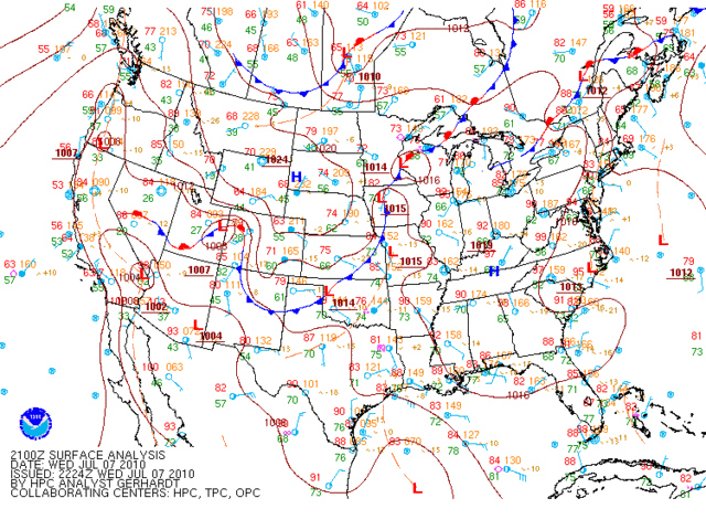
ImageCouple times today I have heard (read) members posts say the rain we are having in SETX is 96L related. Is it? Or is it Remnants of Alex or even 95L...or something all by itself not related to any other system out there?

edited to learn to put images in posts correctly. :roll:
Last edited by Over my head on Wed Jul 07, 2010 6:44 pm, edited 1 time in total.
0 likes   

User avatar
KWT
Category 5
Category 5
Posts: 31415
Joined: Tue Aug 17, 2004 11:02 am
Location: UK!!!

Re: ATL: INVEST 96L - DISCUSSION

#842 Postby KWT » Wed Jul 07, 2010 6:40 pm

Air Force Met wrote:
I agree the trof axis goes through there...but the center is down near the convection. I see w ward moving cu at 24.8...94.

If you just trace the cu field movement around the edges of the overcast...and figure the circulation is in the center of that trace...its at around 24/94


Just had a look and I agree with you, I'd say its on the northern side of the convection but I can see obvious curving of the LLC on the loops drawing down into the convection which would strongly suggesat any center is down in the convection right now, you can just make it out the southerly winds underneath the high clouds on the northern edge of the convection with the low level clouds moving southwards into the convection where there are little chinks in the high cloud shield.

I grant you its not that obvious and I probably wouldn't have clocked it if you hadn't pointed it out but yeah I do see it now on the higher resolution Vis.imagery.
Last edited by KWT on Wed Jul 07, 2010 6:42 pm, edited 1 time in total.
0 likes   
Personal Forecast Disclaimer:
The posts in this forum are NOT official forecast and should not be used as such. They are just the opinion of the poster and may or may not be backed by sound meteorological data. They are NOT endorsed by any professional institution or storm2k.org. For official information, please refer to the NHC and NWS products

ozonepete
Professional-Met
Professional-Met
Posts: 4743
Joined: Mon Sep 07, 2009 3:23 pm
Location: From Ozone Park, NYC / Now in Brooklyn, NY

Re: ATL: INVEST 96L - DISCUSSION

#843 Postby ozonepete » Wed Jul 07, 2010 6:41 pm

KWT wrote:
Air Force Met wrote:
I agree the trof axis goes through there...but the center is down near the convection. I see w ward moving cu at 24.8...94.

If you just trace the cu field movement around the edges of the overcast...and figure the circulation is in the center of that trace...its at around 24/94


Just had a look and I agree with you, I'd say its on the northern side of the convection but I can see obvious curving of the LLC on the loops drawing down into the convection which would strongly suggesat any center is down in the convection right now, you can just make it out underneath the high clouds on the northern edge of the convection with the low level clouds moving southwards into the convection...

I grant you its not that obvious and I probably wouldn't have clocked it if you hadn't pointed it out but yeah I do see it now on the higher resolution Vis.imagery.


I agree with both of you.
0 likes   

Aric Dunn
Category 5
Category 5
Posts: 21238
Age: 42
Joined: Sun Sep 19, 2004 9:58 pm
Location: Ready for the Chase.
Contact:

#844 Postby Aric Dunn » Wed Jul 07, 2010 6:45 pm

as for the organization, clearly the level circ has improved and tightened up but still has very weak banding on the northern semi circle. there is improved low level inflow but minimal organized convection. There is likely a tight enough closed circ at the surface to justify a TD but even then I highly doubt there will be an upgrade for winds around 20 to 25 kts even thought technically a TD is 30kts and below. the upper environment is in favor for development but its forward motion is fairly quick and limits is time over water. so the 50% from the nhc is good to me. so unless some concentrated deep convection develops i dont think will get a TS but a TD could be a possibility.
0 likes   

ozonepete
Professional-Met
Professional-Met
Posts: 4743
Joined: Mon Sep 07, 2009 3:23 pm
Location: From Ozone Park, NYC / Now in Brooklyn, NY

Re: ATL: INVEST 96L - DISCUSSION

#845 Postby ozonepete » Wed Jul 07, 2010 6:45 pm

Over my head wrote:ImageCouple times today I have heard (read) members posts say the rain we are having in SETX is 96L related. Is it? Or is it Remnants of Alex or even 95L...or something all by itself not related to any other system out there?


All by itself. It is coming from areas of stong convection (thunderstorms) rotating from south to north along a trough (see the dotted line in the western Gulf) that lies along the western edge of a very strong Bermuda High anchored over the east/southeast U.S.

Image
0 likes   

djones65
Category 1
Category 1
Posts: 264
Age: 59
Joined: Mon Jun 20, 2005 12:05 am
Location: Ocean Springs, MS

#846 Postby djones65 » Wed Jul 07, 2010 6:46 pm

Looking at recon data from the NOAA P-3 research aircraft shows we have a developing circulation east of 94.4W... The aircraft is flying at 640 mb height and as we saw from yesterday's data their surface pressure extrapolation may not be reliable... However, the aircraft passed from east to west along 26N and reported SE winds of 32 knots at flight level (maybe higher because I didn't get all the data) with an extrapolated pressure of 1004 mb to the NE of the estimated center on satellite. To the NW of the center estimated on satellite they found NE winds of 30 knots and extrapolated surface pressure of 1002 mb near 24.8N and 95.5W The aircraft then traveled due south along longitude 95.5W and reported due north and then northwest and west northwest winds of 15 knots at flight level, but SFMR estimated 30 knots near 22.8N and 94.4W. The aircraft is heading northeast towards where I believe a low level circulation is located and perhaps we could get a vortex message within the next half hour. If the SFMR of 30 knots in SW quadrant is accurate, I would not be surprised to see tropical storm force winds on the NE quadrant. This of course is just my opinion and is not official... But I would not be surprised to see advisories on tropical storm Bonnie later initiated later tonight... Also, latest satellite IR shows some deep convection redeveloping just south of the center.

this is in no way official information and simply my opinion.
0 likes   

Nederlander
S2K Supporter
S2K Supporter
Posts: 1250
Joined: Sat Jul 19, 2008 4:28 pm
Location: Conroe, TX

Re: ATL: INVEST 96L - DISCUSSION

#847 Postby Nederlander » Wed Jul 07, 2010 6:47 pm

Over my head wrote:ImageCouple times today I have heard (read) members posts say the rain we are having in SETX is 96L related. Is it? Or is it Remnants of Alex or even 95L...or something all by itself not related to any other system out there?
edited to learn to put images in posts correctly. :roll:


Pretty sure its because of the ULL slinging moisture inland.. could be wrong
0 likes   

User avatar
ROCK
Category 5
Category 5
Posts: 9484
Age: 54
Joined: Tue Aug 17, 2004 7:30 am
Location: Kemah, Texas

Re: ATL: INVEST 96L - DISCUSSION

#848 Postby ROCK » Wed Jul 07, 2010 6:48 pm

Btw- I have never heard of a member named Crock...;).
0 likes   

supercane
S2K Supporter
S2K Supporter
Posts: 2858
Joined: Wed Sep 16, 2009 8:27 pm

Re:

#849 Postby supercane » Wed Jul 07, 2010 6:51 pm

djones65 wrote:.... perhaps we could get a vortex message within the next half hour.....
this is in no way official information and simply my opinion.


Would a research mission issue a vortex message anyway?
0 likes   

redfish1
Tropical Storm
Tropical Storm
Posts: 125
Age: 44
Joined: Thu Jun 17, 2010 9:24 pm
Location: Port Arthur, Tx

Re:

#850 Postby redfish1 » Wed Jul 07, 2010 6:52 pm

djones65 wrote:Looking at recon data from the NOAA P-3 research aircraft shows we have a developing circulation east of 94.4W... The aircraft is flying at 640 mb height and as we saw from yesterday's data their surface pressure extrapolation may not be reliable... However, the aircraft passed from east to west along 26N and reported SE winds of 32 knots at flight level (maybe higher because I didn't get all the data) with an extrapolated pressure of 1004 mb to the NE of the estimated center on satellite. To the NW of the center estimated on satellite they found NE winds of 30 knots and extrapolated surface pressure of 1002 mb near 24.8N and 95.5W The aircraft then traveled due south along longitude 95.5W and reported due north and then northwest and west northwest winds of 15 knots at flight level, but SFMR estimated 30 knots near 22.8N and 94.4W. The aircraft is heading northeast towards where I believe a low level circulation is located and perhaps we could get a vortex message within the next half hour. If the SFMR of 30 knots in SW quadrant is accurate, I would not be surprised to see tropical storm force winds on the NE quadrant. This of course is just my opinion and is not official... But I would not be surprised to see advisories on tropical storm Bonnie later initiated later tonight... Also, latest satellite IR shows some deep convection redeveloping just south of the center.

so do you think the center is to the northeast of where everyone else thinks it is right now?

this is in no way official information and simply my opinion.
0 likes   

User avatar
wxman57
Moderator-Pro Met
Moderator-Pro Met
Posts: 22978
Age: 67
Joined: Sat Jun 21, 2003 8:06 pm
Location: Houston, TX (southwest)

Re: ATL: INVEST 96L - DISCUSSION

#851 Postby wxman57 » Wed Jul 07, 2010 6:53 pm

Macrocane wrote:
lonelymike wrote:Indeed the pro mets in here are nice enough to share their opinions with us and don't need to get bashed or questioned. Having had friends go through met school at FSU I can tell you its no easy major. So disagree with a smile if you must. I would hate to lose the opinions of wxman57, Air Force Met or Truesms and others like them because of ill considered comments.

And if they leave the only show in town will be the Euro wars nightly with Crock and Ivan :D


:lol:

I find interesting how even the pro-mets sometimes disagree, and in cases like 96L they tend to disagree more, I really appreciate all of their opinions.


We do disagree, sometimes, but respectfully. Usually it'll be on questionable calls like this one. Without a lot of facts (unquestionable data/obs), all we have are our opinions. AFM's an excellent meteorologist. Should be getting the updated tropical outlook from the NHC shortly. Just got the East Pac outlook. That'll be a big clue, as will the header on the 00z model data.
0 likes   

User avatar
cycloneye
Admin
Admin
Posts: 145307
Age: 68
Joined: Thu Oct 10, 2002 10:54 am
Location: San Juan, Puerto Rico

Re: ATL: INVEST 96L - DISCUSSION

#852 Postby cycloneye » Wed Jul 07, 2010 6:53 pm

Up to 80%

TWOAT
TROPICAL WEATHER OUTLOOK
NWS TPC/NATIONAL HURRICANE CENTER MIAMI FL
800 PM EDT WED JUL 7 2010

FOR THE NORTH ATLANTIC...CARIBBEAN SEA AND THE GULF OF MEXICO...

A LARGE LOW PRESSURE SYSTEM LOCATED ABOUT 290 MILES SOUTHEAST OF THE
TEXAS/MEXICO BORDER IS MOVING WEST-NORTHWESTWARD AT 10 TO 15 MPH.
THIS SYSTEM HAS BECOME MUCH BETTER ORGANIZED THIS AFTERNOON AND
EVENING...AND THUNDERSTORM ACTIVITY HAS BECOME MORE CONCENTRATED
NEAR THE CENTER. TWO NOAA RECONNAISSANCE AIRCRAFT ARE CURRENTLY
CONDUCTING A RESEARCH MISSION IN AND AROUND THE DISTURBANCE...AND
INFORMATION RECEIVED SO FAR SUGGESTS THAT A TROPICAL DEPRESSION MAY
BE FORMING. ENVIRONMENTAL CONDITIONS ARE CONDUCIVE FOR FURTHER
DEVELOPMENT AND IF ADDITIONAL ORGANIZATION CONTINUES...THEN
FORECAST ADVISORIES WILL BE INITIATED LATER TONIGHT OR THURSDAY
MORNING...WHICH WOULD REQUIRE THAT TROPICAL STORM WATCHES OR
WARNINGS BE ISSUED FOR PORTIONS OF THE COASTAL REGIONS OF CENTRAL
AND LOWER TEXAS AND NORTHEASTERN MEXICO. THERE IS A HIGH
CHANCE...80 PERCENT...OF THIS SYSTEM BECOMING A TROPICAL CYCLONE.
THIS DISTURBANCE IS FORECAST TO BRING LOCALLY HEAVY RAINS AND GUSTY
WINDS TO PORTIONS OF EASTERN AND SOUTHERN TEXAS AND NORTHEASTERN
MEXICO OVER THE NEXT FEW DAYS.

ELSEWHERE...TROPICAL CYCLONE FORMATION IS NOT EXPECTED DURING THE
NEXT 48 HOURS.

$$
FORECASTER STEWART/CANGIALOSI

Image
0 likes   
Visit the Caribbean-Central America Weather Thread where you can find at first post web cams,radars
and observations from Caribbean basin members Click Here

User avatar
Over my head
Tropical Depression
Tropical Depression
Posts: 86
Joined: Sat Aug 18, 2007 7:52 pm
Location: Southeast Texas

Re: ATL: INVEST 96L - DISCUSSION

#853 Postby Over my head » Wed Jul 07, 2010 6:55 pm

ozonepete wrote:
Over my head wrote:ImageCouple times today I have heard (read) members posts say the rain we are having in SETX is 96L related. Is it? Or is it Remnants of Alex or even 95L...or something all by itself not related to any other system out there?


All by itself. It is coming from areas of stong convection (thunderstorms) rotating from south to north along a trough (see the dotted line in the western Gulf) that lies along the western edge of a very strong Bermuda High anchored over the east/southeast U.S.


Thanks Ozonepete, I'd also read either last night or early this morning that the strongest winds from 96l could be 1 to 200 miles away from it's center which made me wonder it could very well be what we were experiencing. So no effects from 96l yet. Image
0 likes   

User avatar
chzzdekr81
S2K Supporter
S2K Supporter
Posts: 189
Joined: Sun Aug 30, 2009 7:54 pm
Location: Orange, Texas (SETX)
Contact:

#854 Postby chzzdekr81 » Wed Jul 07, 2010 6:55 pm

Code Red!
0 likes   
I survived Rita, Humberto, Edouard, and Ike.

User avatar
HURAKAN
Professional-Met
Professional-Met
Posts: 46086
Age: 38
Joined: Thu May 20, 2004 4:34 pm
Location: Key West, FL
Contact:

#855 Postby HURAKAN » Wed Jul 07, 2010 6:55 pm

Hooray For Steward!!!!
0 likes   

User avatar
KWT
Category 5
Category 5
Posts: 31415
Joined: Tue Aug 17, 2004 11:02 am
Location: UK!!!

#856 Postby KWT » Wed Jul 07, 2010 6:55 pm

I think you'll be safe this time Wxman57, though I do think they'll raise to maybe as high as 70% with this one, going cherry time!

a TS is debatable, but a TD is certainly within the realms of whats possible and you never quite know with these systems as they reach land, it can do them a world of good when they are quite weak with regards to land friction helping to tighten up a system, though the more westerly it moves the better the chances of this happening is IMO.

Edit---nope even higher, upto 80%!
Last edited by KWT on Wed Jul 07, 2010 6:56 pm, edited 1 time in total.
0 likes   
Personal Forecast Disclaimer:
The posts in this forum are NOT official forecast and should not be used as such. They are just the opinion of the poster and may or may not be backed by sound meteorological data. They are NOT endorsed by any professional institution or storm2k.org. For official information, please refer to the NHC and NWS products

Aric Dunn
Category 5
Category 5
Posts: 21238
Age: 42
Joined: Sun Sep 19, 2004 9:58 pm
Location: Ready for the Chase.
Contact:

#857 Postby Aric Dunn » Wed Jul 07, 2010 6:56 pm

this buoy is relatively close and has a pressure of 1007 mb but only a whopping 2kts of wind.. lol
location 22.017 N 94.046 W nearly directly south of estimated center.. so pressure is likely somewhere near 1004 or 1005 mb

http://www.ndbc.noaa.gov/station_page.php?station=42055
0 likes   

User avatar
bvigal
S2K Supporter
S2K Supporter
Posts: 2276
Joined: Sun Jul 24, 2005 8:49 am
Location: British Virgin Islands
Contact:

Re: ATL: INVEST 96L - DISCUSSION

#858 Postby bvigal » Wed Jul 07, 2010 6:56 pm

lonelymike wrote:Indeed the pro mets in here are nice enough to share their opinions with us and don't need to get bashed or questioned. Having had friends go through met school at FSU I can tell you its no easy major. So disagree with a smile if you must. I would hate to lose the opinions of wxman57, Air Force Met or Truesms and others like them because of ill considered comments.

And if they leave the only show in town will be the Euro wars nightly with Crock and Ivan :D

Yes, thanks to ALL our pro mets for their contributions!!! And, many of our experienced 'amateurs' have some valuable and much-appreciated insights, too. Like to see less of the unsupported :yesno: ;-)
0 likes   

supercane
S2K Supporter
S2K Supporter
Posts: 2858
Joined: Wed Sep 16, 2009 8:27 pm

Re: ATL: INVEST 96L - DISCUSSION

#859 Postby supercane » Wed Jul 07, 2010 6:58 pm

wxman57 wrote:
ozonepete wrote:
wx88 wrote:I think someone may be blinded by a free lunch. I think it is a TD already.


Yeah, wxman57. Looks like your lunch will be crow. :wink:


You really think NHC will upgrade within the next 1hr 45 min? Not likely. The bet was by 7pm CDT tonight, not ever.


Congratulations on the free lunch. Lucky that the bet was for an operational upgrade and not best track, given the implications of the updated TWO.
0 likes   

User avatar
KWT
Category 5
Category 5
Posts: 31415
Joined: Tue Aug 17, 2004 11:02 am
Location: UK!!!

Re:

#860 Postby KWT » Wed Jul 07, 2010 6:59 pm

Its interesting to see the NHC say that a depression maybe forming, I'd imagine they just want to see it keep on its current trend, in other words its the NHC saying, 6 more hours and if we don't see any sign of degrading we will probably pull the trigger with just another small improvement...

They are probably waiting for slightly deeper convection to fire in D-max to pull the trigger.
0 likes   
Personal Forecast Disclaimer:
The posts in this forum are NOT official forecast and should not be used as such. They are just the opinion of the poster and may or may not be backed by sound meteorological data. They are NOT endorsed by any professional institution or storm2k.org. For official information, please refer to the NHC and NWS products


Return to “2010”

Who is online

Users browsing this forum: No registered users and 2 guests