
This area has been producing weak to moderate convection for a few days now and I'm starting to see the slightest little curvature to storms this morning. Pressures are about normal but this a climatology favored area. so it may be something to watch over the next few days.
http://mkwc.ifa.hawaii.edu/satellite/sa ... verlay=off
Disturbed Area in Central Gulf of Mexico
Moderator: S2k Moderators
Forum rules

The posts in this forum are NOT official forecasts and should not be used as such. They are just the opinion of the poster and may or may not be backed by sound meteorological data. They are NOT endorsed by any professional institution or STORM2K. For official information, please refer to products from the National Hurricane Center and National Weather Service.
Disturbed Area in Central Gulf of Mexico
0 likes
The following post is NOT an official forecast and should not be used as such. It is just the opinion of the poster and may or may not be backed by sound meteorological data. It is NOT endorsed by any professional institution including storm2k.org For Official Information please refer to the NHC and NWS products.

Re: Disturbed area near the Bahamas
I've been watching this area closely. In fact, the NAM pushes this area west into S.Fl/Gulf in about 3-4 days as ridging builds to the north..Climatology and recent satellite imagery certainly maintain we keep a watchul eye on this area.
0 likes
Re: Disturbed area near the Bahamas
From NWS Mami this morning:
BOTH GFS/ECWMF ARE MORE AGGRESSIVE WITH MOISTURE INCREASING ON
WED...SHOWING AN INVERTED TROUGH MOVING ACROSS THE
AREA...ORIGINATING FROM CONVECTION NEAR THE TURKS AND CAICOS
ISLANDS. THE CONVECTION CURRENTLY IN THAT AREA LOOKS TO BE ALONG A
SHEAR AXIS. GIVEN THE AMOUNT OF TSTORMS IN THAT AREA NOW...DECIDED
TO INCREASE POPS TO 50 ALL AREAS FOR WED. GFS SHOWS LIKELY POPS
EAST COAST WED...BUT WOULD LIKE TO WATCH THE PROGRESSION OF
CONVECTION TO OUR SE BEFORE JUMPING TOO HIGH ON POPS SINCE IT`S A
FEW DAYS OUT.
0 likes


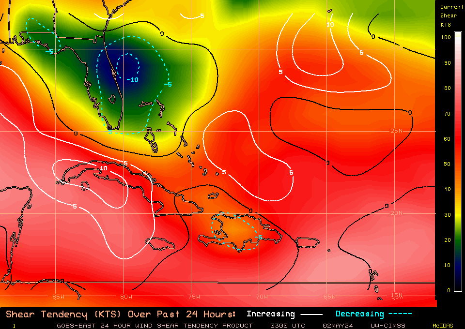
Looks like shear is pretty high throughout the entire region this convection is in. So therefore I doubt anything has a shot really...not unless it can find a pocket of lower shear.
0 likes
Personal Forecast Disclaimer:
The posts in this forum are NOT official forecast and should not be used as such. They are just the opinion of the poster and may or may not be backed by sound meteorological data. They are NOT endorsed by any professional institution or storm2k.org. For official information, please refer to the NHC and NWS products
The posts in this forum are NOT official forecast and should not be used as such. They are just the opinion of the poster and may or may not be backed by sound meteorological data. They are NOT endorsed by any professional institution or storm2k.org. For official information, please refer to the NHC and NWS products
-
Blown Away

- S2K Supporter

- Posts: 10253
- Joined: Wed May 26, 2004 6:17 am
Re: Disturbed area near the Bahamas
I see very broad weak turning in the area of 26N/70W. Lots of covection and maybe it gets a Code Yellow with a 0% chance of development at 2pm?? I love when the NHC gives a 0% chance of development, don't know why I just find that funny!
0 likes
Hurricane Eye Experience: David 79, Irene 99, Frances 04, Jeanne 04, Wilma 05… Hurricane Brush Experience: Andrew 92, Erin 95, Floyd 99, Matthew 16, Irma 17, Ian 22, Nicole 22…

Re: Disturbed area near the Bahamas
As the ridge builds in the shear may decrease. Actually if this current convective cycle persists tonight they will probably declare an invest. They are only forecasting an inverted trough for south Florida? I did see some turning in the low resolution loop so I was thinking possible depression by Wednesday.
0 likes

Re: Disturbed area near the Bahamas
we need a pro met to chime in on this area.
This is a favored area for development.
This is a favored area for development.
0 likes
Re: Disturbed area near the Bahamas

0 likes
The following post is NOT an official forecast and should not be used as such. It is just the opinion of the poster and may or may not be backed by sound meteorological data. It is NOT endorsed by any professional institution including storm2k.org For Official Information please refer to the NHC and NWS products.
Shear still looks a good deal too high throughout the region, if anything the Atlantic has seen a decent increase in shear over the last 2 weeks..
0 likes
Personal Forecast Disclaimer:
The posts in this forum are NOT official forecast and should not be used as such. They are just the opinion of the poster and may or may not be backed by sound meteorological data. They are NOT endorsed by any professional institution or storm2k.org. For official information, please refer to the NHC and NWS products
The posts in this forum are NOT official forecast and should not be used as such. They are just the opinion of the poster and may or may not be backed by sound meteorological data. They are NOT endorsed by any professional institution or storm2k.org. For official information, please refer to the NHC and NWS products
Re: Disturbed area near the Bahamas
Vorticity up a little also.

Not really supposed to do much for the next couple days and it is the NAM, so we shall see.
0 likes
The following post is NOT an official forecast and should not be used as such. It is just the opinion of the poster and may or may not be backed by sound meteorological data. It is NOT endorsed by any professional institution including storm2k.org For Official Information please refer to the NHC and NWS products.

Re: Disturbed area near the Bahamas
It went poof. Not really anything there anymore.
http://www.sun-sentinel.com/news/weathe ... ane/radar/
http://www.sun-sentinel.com/news/weathe ... ane/radar/
0 likes


Re: Disturbed area near the Bahamas
A lot less intensity on this run but it looks like it could be bring more rain to an area that doesn't really need it.
Hardly any convection right now but I think it showing some small signs of organization. still a couple days away.
http://www.nco.ncep.noaa.gov/pmb/nwprod ... loop.shtml
Hardly any convection right now but I think it showing some small signs of organization. still a couple days away.
http://www.nco.ncep.noaa.gov/pmb/nwprod ... loop.shtml
0 likes
The following post is NOT an official forecast and should not be used as such. It is just the opinion of the poster and may or may not be backed by sound meteorological data. It is NOT endorsed by any professional institution including storm2k.org For Official Information please refer to the NHC and NWS products.
Re: Disturbed area in southern gulf
Well the good ole NAM is still trying to develop this area that has moved westward from near the Bahama's. But in it's defense, it never really develop it until Friday and now Sat. watch out Houston. 
http://www.nco.ncep.noaa.gov/pmb/nwprod ... loop.shtml
http://radar.weather.gov/radar.php?prod ... w&loop=yes
http://www.nco.ncep.noaa.gov/pmb/nwprod ... loop.shtml
http://radar.weather.gov/radar.php?prod ... w&loop=yes
0 likes
The following post is NOT an official forecast and should not be used as such. It is just the opinion of the poster and may or may not be backed by sound meteorological data. It is NOT endorsed by any professional institution including storm2k.org For Official Information please refer to the NHC and NWS products.
Re: Disturbed area near the Bahamas
Could I get one of the Mods to change the Title to GOM instead area near the Bahama's. It looks like it is starting to flare up this morning maybe something to watch a little closer?
0 likes
The following post is NOT an official forecast and should not be used as such. It is just the opinion of the poster and may or may not be backed by sound meteorological data. It is NOT endorsed by any professional institution including storm2k.org For Official Information please refer to the NHC and NWS products.
-
wxman57

- Moderator-Pro Met

- Posts: 23175
- Age: 68
- Joined: Sat Jun 21, 2003 8:06 pm
- Location: Houston, TX (southwest)
Re: Disturbed area near the Bahamas
tailgater wrote:Could I get one of the Mods to change the Title to GOM instead area near the Bahama's. It looks like it is starting to flare up this morning maybe something to watch a little closer?
I changed the title, but it's just an upper-level low. A wave passing to the south is enhancing convection today, but development chances are minimal.
0 likes

Re: Disturbed area near the Bahamas
Are we talking about this blob just SE of FL:

It does look interesting in this WV loop:
http://www.ssd.noaa.gov/goes/east/carb/loop-wv.html
--

It does look interesting in this WV loop:
http://www.ssd.noaa.gov/goes/east/carb/loop-wv.html
--
0 likes
-
dolebot_Broward_NW
- Category 2

- Posts: 529
- Joined: Fri Sep 10, 2004 6:38 am
Re: Disturbed Area Entering Southeastern Gulf of Mexico
just an upper-level low
Been watching this guy near SFL for a couple days. Brought moisture up and decent rain yesterday - last night we had some epic t-storms. Nice little blob out there SE of Key Largo. Expecting a great and awesome day of tropical showers all afternoon.
0 likes
-
bbadon
- Tropical Storm

- Posts: 190
- Joined: Fri Sep 05, 2003 7:21 am
- Location: Johnson Bayou, LA
- Contact:
Re: Disturbed Area Entering Southeastern Gulf of Mexico
What I'm looking at is more central gulf(25,90ish). Not the ULL. On the first few visibles you can see some lower level broad rotation in this area. Convections starts building we could have a problem.
0 likes
Radar shows alot of rain heading towards S.Florida with this wave, decent convection aloft but I'd suspect there will be no development with this one...
Still need to watch because there is a lot of rain heading into Florida today.
Still need to watch because there is a lot of rain heading into Florida today.
0 likes
Personal Forecast Disclaimer:
The posts in this forum are NOT official forecast and should not be used as such. They are just the opinion of the poster and may or may not be backed by sound meteorological data. They are NOT endorsed by any professional institution or storm2k.org. For official information, please refer to the NHC and NWS products
The posts in this forum are NOT official forecast and should not be used as such. They are just the opinion of the poster and may or may not be backed by sound meteorological data. They are NOT endorsed by any professional institution or storm2k.org. For official information, please refer to the NHC and NWS products
Who is online
Users browsing this forum: No registered users and 198 guests