WPAC : TROPICAL DEPRESSION CONSON

Moderator: S2k Moderators

Message
Author
Typhoon Hunter
WesternPacificWeather.com
Posts: 1221
Joined: Wed Oct 11, 2006 11:37 am
Location: Tokyo
Contact:

Re: WPAC : SEVERE TROPICAL STORM CONSON / JTWC,PAGA=TY

#241 Postby Typhoon Hunter » Tue Jul 13, 2010 8:07 am

dexterlabio wrote:Conson has weakened, according to JMA.


To be expected given its proximity to land. JMA still forecasting for a potent typhoon threatening Guangdong province in 3 days time.
Last edited by Typhoon Hunter on Tue Jul 13, 2010 8:08 am, edited 1 time in total.
0 likes   
James - Documenting tropical cyclones...

http://www.youtube.com/TyphoonHunter

User avatar
drdavisjr
Category 1
Category 1
Posts: 428
Age: 57
Joined: Mon Oct 12, 2009 7:07 am
Location: Marilao, Bulacan, Philippines
Contact:

#242 Postby drdavisjr » Tue Jul 13, 2010 8:08 am

I'm following the tweets about the storm, http://twitter.com/#search?q=Basyang

It's amazing how many people from Manila are just now becoming aware that there is a storm in the area.
0 likes   

User avatar
drdavisjr
Category 1
Category 1
Posts: 428
Age: 57
Joined: Mon Oct 12, 2009 7:07 am
Location: Marilao, Bulacan, Philippines
Contact:

Re: WPAC : SEVERE TROPICAL STORM CONSON / JTWC,PAGA=TY

#243 Postby drdavisjr » Tue Jul 13, 2010 8:10 am

Typhoon Hunter wrote:
dexterlabio wrote:Conson has weakened, according to JMA.


To be expected given its proximity to land. JMA still forecasting for a potent typhoon threatening Guangdong province in 3 days time.


This is the last thing southern China needs at the moment. The East-Asia Monsoon has been very devastating.
0 likes   

dexterlabio
Category 5
Category 5
Posts: 3468
Joined: Sat Oct 24, 2009 11:50 pm

Re:

#244 Postby dexterlabio » Tue Jul 13, 2010 8:15 am

drdavisjr wrote:I'm following the tweets about the storm, http://twitter.com/#search?q=Basyang

It's amazing how many people from Manila are just now becoming aware that there is a storm in the area.


Yeah, but all of them don't know that Basyang most probably will hit Manila, not anywhere else.

Winds getting stronger here. :double:
0 likes   
Personal Forecast Disclaimer:
The posts in this forum are NOT official forecast and should not be used as such. They are just the opinion of the poster and may or may not be backed by sound meteorological data. They are NOT endorsed by any professional institution or storm2k.org. For official information, please refer to the NHC and NWS products.

Typhoon Hunter
WesternPacificWeather.com
Posts: 1221
Joined: Wed Oct 11, 2006 11:37 am
Location: Tokyo
Contact:

Re: WPAC : SEVERE TROPICAL STORM CONSON / JTWC,PAGA=TY

#245 Postby Typhoon Hunter » Tue Jul 13, 2010 8:21 am

Quite a startling chart here of current SSTs. They are pretty damn hot across most of the Philippine and South China Sea!!!
http://www.ssmi.com/graphics/fusion/sst/graphics_v01/tmi_amsre/small/global/y2010/m07/tmi_amsre_2010_07_13_sst.png
0 likes   
James - Documenting tropical cyclones...

http://www.youtube.com/TyphoonHunter

User avatar
ManilaTC
WesternPacificWeather.com
Posts: 593
Age: 47
Joined: Mon Oct 26, 2009 5:13 am
Location: Mandaluyong City, Philippines
Contact:

Re: WPAC : SEVERE TROPICAL STORM CONSON / JTWC,PAGA=TY

#246 Postby ManilaTC » Tue Jul 13, 2010 8:23 am

MIMIC Microwave shows that Conson is now about to make landfall at N Quezon.
Image
0 likes   
The above post is NOT official and should not be used as such. It is my opinion and may or may not be backed by sound meteorological data. It is not endorsed by any professional institution or storm2k.org. Please refer to your official national weather agency.

WEB http://goo.gl/JDiKXB | FB https://goo.gl/N5sIle | @ManilaTC

oaba09
S2K Supporter
S2K Supporter
Posts: 1496
Age: 38
Joined: Thu Oct 01, 2009 10:02 am
Location: Valenzuela, Philippines
Contact:

#247 Postby oaba09 » Tue Jul 13, 2010 8:27 am

Yup...wind is picking up in my area....
0 likes   

User avatar
drdavisjr
Category 1
Category 1
Posts: 428
Age: 57
Joined: Mon Oct 12, 2009 7:07 am
Location: Marilao, Bulacan, Philippines
Contact:

Re:

#248 Postby drdavisjr » Tue Jul 13, 2010 8:31 am

oaba09 wrote:Yup...wind is picking up in my area....


Are you getting rain there?
0 likes   

dexterlabio
Category 5
Category 5
Posts: 3468
Joined: Sat Oct 24, 2009 11:50 pm

Re: WPAC : SEVERE TROPICAL STORM CONSON / JTWC,PAGA=TY

#249 Postby dexterlabio » Tue Jul 13, 2010 8:35 am

Rain is continuous in our area, accompanied with mild to strong breeze. It is cold out here. :froze:
0 likes   
Personal Forecast Disclaimer:
The posts in this forum are NOT official forecast and should not be used as such. They are just the opinion of the poster and may or may not be backed by sound meteorological data. They are NOT endorsed by any professional institution or storm2k.org. For official information, please refer to the NHC and NWS products.

User avatar
Infdidoll
Category 2
Category 2
Posts: 667
Age: 47
Joined: Thu Oct 01, 2009 8:39 pm
Location: Temecula, CA

Re: WPAC : SEVERE TROPICAL STORM CONSON / JTWC,PAGA=TY

#250 Postby Infdidoll » Tue Jul 13, 2010 8:38 am

Interesting...is that an elongated eye from the north side being impacted by shear?

Image
0 likes   

oaba09
S2K Supporter
S2K Supporter
Posts: 1496
Age: 38
Joined: Thu Oct 01, 2009 10:02 am
Location: Valenzuela, Philippines
Contact:

Re: Re:

#251 Postby oaba09 » Tue Jul 13, 2010 8:38 am

drdavisjr wrote:
oaba09 wrote:Yup...wind is picking up in my area....


Are you getting rain there?


Not much...mostly wind...
0 likes   

dexterlabio
Category 5
Category 5
Posts: 3468
Joined: Sat Oct 24, 2009 11:50 pm

Re: WPAC : SEVERE TROPICAL STORM CONSON / JTWC,PAGA=TY

#252 Postby dexterlabio » Tue Jul 13, 2010 8:40 am

Take a look at this satpic. The last time I saw those wide area of red marks over Manila and nearby places is when Ketsana(Ondoy) hit Luzon. Conson suddenly had these bursts of deep convection near its center.

Image
0 likes   
Personal Forecast Disclaimer:
The posts in this forum are NOT official forecast and should not be used as such. They are just the opinion of the poster and may or may not be backed by sound meteorological data. They are NOT endorsed by any professional institution or storm2k.org. For official information, please refer to the NHC and NWS products.

User avatar
drdavisjr
Category 1
Category 1
Posts: 428
Age: 57
Joined: Mon Oct 12, 2009 7:07 am
Location: Marilao, Bulacan, Philippines
Contact:

Re: WPAC : SEVERE TROPICAL STORM CONSON / JTWC,PAGA=TY

#253 Postby drdavisjr » Tue Jul 13, 2010 8:44 am

From what I can tell, the eye is here.

Image
0 likes   

User avatar
drdavisjr
Category 1
Category 1
Posts: 428
Age: 57
Joined: Mon Oct 12, 2009 7:07 am
Location: Marilao, Bulacan, Philippines
Contact:

Re: WPAC : SEVERE TROPICAL STORM CONSON / JTWC,PAGA=TY

#254 Postby drdavisjr » Tue Jul 13, 2010 8:45 am

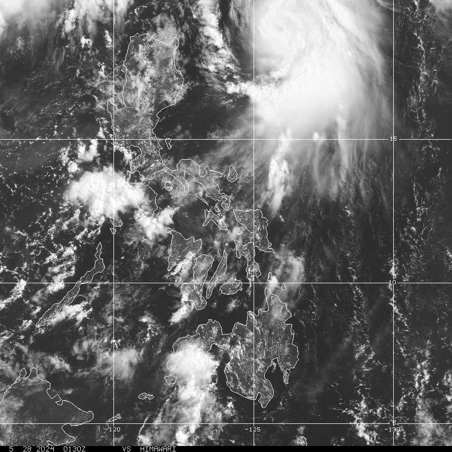
dexterlabio wrote:Take a look at this satpic. The last time I saw those wide area of red marks over Manila and nearby places is when Ketsana(Ondoy) hit Luzon. Conson suddenly had these bursts of deep convection near its center.

Image


True, but north of here, closer to Aurora. This one is right on top of us. :double:
0 likes   

dexterlabio
Category 5
Category 5
Posts: 3468
Joined: Sat Oct 24, 2009 11:50 pm

Re: WPAC : SEVERE TROPICAL STORM CONSON / JTWC,PAGA=TY

#255 Postby dexterlabio » Tue Jul 13, 2010 8:51 am

So there was a strong brush of wind a while ago outside my house... I thought that was already the core, but the center is not yet even in the Polilio islands, isn't it?
0 likes   
Personal Forecast Disclaimer:
The posts in this forum are NOT official forecast and should not be used as such. They are just the opinion of the poster and may or may not be backed by sound meteorological data. They are NOT endorsed by any professional institution or storm2k.org. For official information, please refer to the NHC and NWS products.

ricmood

#256 Postby ricmood » Tue Jul 13, 2010 8:51 am

Plus this is a 20kph typhoon. I think Ketsana was about 8-15kph
0 likes   

dexterlabio
Category 5
Category 5
Posts: 3468
Joined: Sat Oct 24, 2009 11:50 pm

Re: WPAC : SEVERE TROPICAL STORM CONSON / JTWC,PAGA=TY

#257 Postby dexterlabio » Tue Jul 13, 2010 8:54 am

Conson would be off the coast of Zambales tomorrow morning (around 5 or 6am I think), so there are roughly 6 to 7 hours of rains and winds to be felt. I'll be watching for the local news later on...
0 likes   
Personal Forecast Disclaimer:
The posts in this forum are NOT official forecast and should not be used as such. They are just the opinion of the poster and may or may not be backed by sound meteorological data. They are NOT endorsed by any professional institution or storm2k.org. For official information, please refer to the NHC and NWS products.

User avatar
drdavisjr
Category 1
Category 1
Posts: 428
Age: 57
Joined: Mon Oct 12, 2009 7:07 am
Location: Marilao, Bulacan, Philippines
Contact:

Re: WPAC : SEVERE TROPICAL STORM CONSON / JTWC,PAGA=TY

#258 Postby drdavisjr » Tue Jul 13, 2010 8:54 am

dexterlabio wrote:So there was a strong brush of wind a while ago outside my house... I thought that was already the core, but the center is not yet even in the Polilio islands, isn't it?


I think it squeezed itself in between Polillo and Camarines Norte ... can you believe it? All that warm water to energize it :)
0 likes   

ricmood

#259 Postby ricmood » Tue Jul 13, 2010 8:54 am

First major storm of the year and it is already near Manila. Wow, get ready for 13-15 more.
0 likes   

oaba09
S2K Supporter
S2K Supporter
Posts: 1496
Age: 38
Joined: Thu Oct 01, 2009 10:02 am
Location: Valenzuela, Philippines
Contact:

#260 Postby oaba09 » Tue Jul 13, 2010 8:56 am

according to typhoon2000,

"Typhoon CONSON (BASYANG) moving away from Camarines Norte...now entering Lamon Bay as it approaches Polillo Island & Northern Quezon...endangers Metro Manila & Bulacan.

*Residents and visitors along Metro Manila, Central & Southern Luzon should closely monitor the progress of CONSON (BASYANG)."
0 likes   


Return to “2010”

Who is online

Users browsing this forum: No registered users and 1 guest