ATL: TROPICAL DEPRESSION BONNIE - DISCUSSION
Moderator: S2k Moderators
-
gatorcane

- S2K Supporter

- Posts: 23708
- Age: 48
- Joined: Sun Mar 13, 2005 3:54 pm
- Location: Boca Raton, FL
Well we continue to be fortunate the upper-level low is lurking off to its NNW. That is pumping in dry air from the NW into the western side of 97L. But this ULL is forecasted to eventually weaken and should be replaced by a ridge axis that builds in just to the north. When that happens, we could see some strengthening. Question will be, how much time will it have over water should it impact SE FL? Could it be like a Katrina where it moved ashore before becoming too strong? Had Katrina had another 24 hours over water, I'm pretty sure we would be talking a CAT 3 instead of a CAT 1 into SE FL.
Last edited by gatorcane on Tue Jul 20, 2010 9:20 pm, edited 1 time in total.
0 likes

Re: ATL: INVEST 97L - DISCUSSION
I don't see the increased organization that most are talking about, to me the whole western side of the invest will be under the ULL or TUTT for at least the next 24 to 36 hrs. what am I missing? No signs of LLC that i can see.
0 likes
The following post is NOT an official forecast and should not be used as such. It is just the opinion of the poster and may or may not be backed by sound meteorological data. It is NOT endorsed by any professional institution including storm2k.org For Official Information please refer to the NHC and NWS products.

-
hurricaneCW
- Category 5

- Posts: 1799
- Joined: Wed Mar 03, 2010 6:20 am
- Location: Toms River, NJ
Re: ATL: INVEST 97L - DISCUSSION
97L isn't the cleanest way to get a storm. So far, Alex and TD 2 struggled with dry air and wind shear before developing and this one's no different. I'm thinking tonight's maximum allows it to consolidate more and cause a pressure drop. The earliest for a TD would probably be early Thursday.
0 likes
-
wxman57

- Moderator-Pro Met

- Posts: 23175
- Age: 68
- Joined: Sat Jun 21, 2003 8:06 pm
- Location: Houston, TX (southwest)
Re: ATL: INVEST 97L - DISCUSSION
Macrocane wrote:cpdaman wrote:some excitement brewing...
just stopping bye.....anyone have any preliminary potential with this thing....
high end TC....low end cane? as far as s. fl is concerned ....i could some family down there
I think it was Wxman57 who said that it could be a cat 1 or even cat 2 hurricane.
Not a Cat 2 by Florida, by the northern Gulf Coast. Probably a lower-end Cat 1 when it reaches Florida.
0 likes
-
Bocadude85

- Category 5
- Posts: 2991
- Age: 39
- Joined: Mon Apr 18, 2005 2:20 pm
- Location: Honolulu,Hi
Re: ATL: INVEST 97L - DISCUSSION
wxman57 what do you think the chances of develpment are? do you think 97L is becoming less organized?
0 likes
-
Blown Away

- S2K Supporter
- Posts: 10253
- Joined: Wed May 26, 2004 6:17 am
Re: ATL: INVEST 97L - DISCUSSION
Look at the WV Loop and you can see the dry moistening, another 12 hours and the dry will not be a big factor.
http://www.ssd.noaa.gov/goes/east/tatl/loop-wv.html
http://www.ssd.noaa.gov/goes/east/tatl/loop-wv.html
0 likes
Hurricane Eye Experience: David 79, Irene 99, Frances 04, Jeanne 04, Wilma 05… Hurricane Brush Experience: Andrew 92, Erin 95, Floyd 99, Matthew 16, Irma 17, Ian 22, Nicole 22…


-
gatorcane
- S2K Supporter
- Posts: 23708
- Age: 48
- Joined: Sun Mar 13, 2005 3:54 pm
- Location: Boca Raton, FL
I can't really detect much of a movement still. Looks like it is nearly stationary. If you look where it was this morning and now, really hasn't moved. Thoughts?
Last edited by gatorcane on Tue Jul 20, 2010 9:38 pm, edited 1 time in total.
0 likes
Re:
Aquawind wrote:I hear ya tailgater.. Nothing visually impressive related to any llc as of yet. Some displaced deeper convection to the east of the best track location but, no obs yet either..same ole slow process..
Here's another factor or 2 against development anytime soon.
notice the increase right in the projected path.
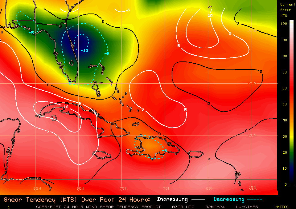
and at the mid levels also.
0 likes
The following post is NOT an official forecast and should not be used as such. It is just the opinion of the poster and may or may not be backed by sound meteorological data. It is NOT endorsed by any professional institution including storm2k.org For Official Information please refer to the NHC and NWS products.
-
Lowpressure

- S2K Supporter
- Posts: 2032
- Age: 59
- Joined: Sun Sep 14, 2003 9:17 am
- Location: Charlotte, North Carolina
Re: ATL: INVEST 97L - DISCUSSION
Still looks elongated as a sharp trough axis. Trying to organize, but will take a little time for sure. Recon tomorrow will be interesting.
0 likes
-
ConvergenceZone
.gif)
- Category 5
- Posts: 5241
- Joined: Fri Jul 29, 2005 1:40 am
- Location: Northern California
Re: ATL: INVEST 97L - DISCUSSION
Steve H. wrote:I think shear is still the main inhibiting factor here. That ULL to the NNW of 97L has been diving SW all day. That is why we are seeing an elongation of the disturbance during the past 6 hours. If this doesn't abate I think we won't have a well established surface circulation for a few days.
I don't think this is true, because in a few days, this will be on land.
0 likes

Re: ATL: INVEST 97L - DISCUSSION
Why isn't 97L moving quicker,you would think with the strong high to its north it would give 97L momentum.
0 likes
-
MiamiHurricanes10

- S2K Supporter
- Posts: 260
- Joined: Mon Jul 19, 2010 7:56 pm
- Location: Miami, Florida
Re: Re:
tailgater wrote:Aquawind wrote:I hear ya tailgater.. Nothing visually impressive related to any llc as of yet. Some displaced deeper convection to the east of the best track location but, no obs yet either..same ole slow process..
Here's another factor or 2 against development anytime soon.
notice the increase right in the projected path.
and at the mid levels also.
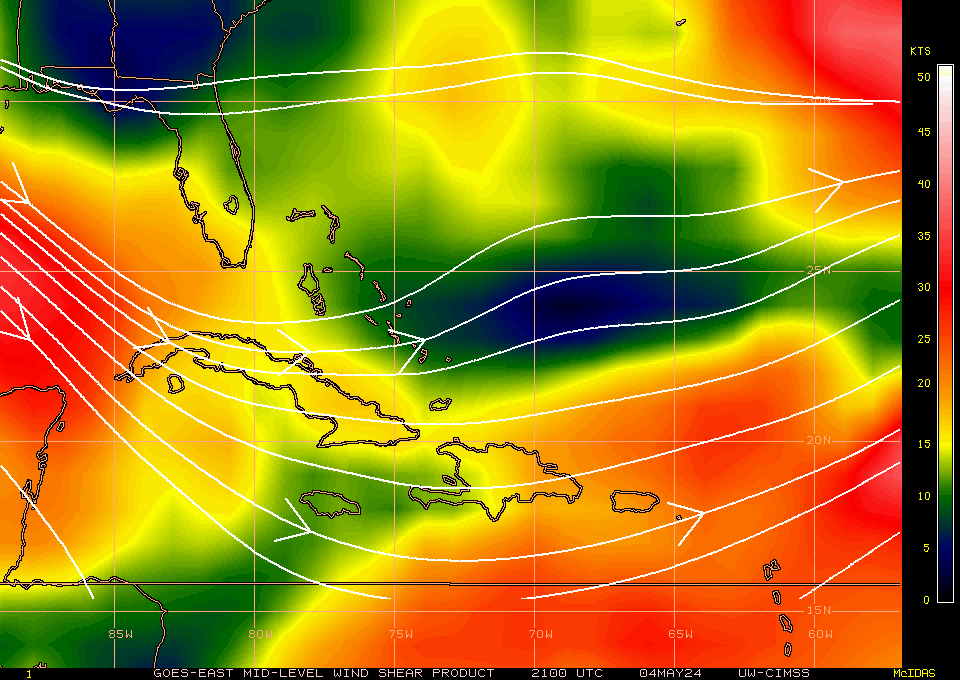
The ULL is obviously weakening as it is looking more like a trough-like feature (evident on 200mb vorticity), that is what the increase of shear is attributed to in the past 24 hours. As the ULL ventures off to the west with continuous weakening, 97L will be under favorable upper level winds. Also, as of late anticyclonic flow is evident on 97L with latest CIMSS graphs showing that we are currently going through anticyclogenesis atop 97L.
0 likes
-
Blown Away
- S2K Supporter
- Posts: 10253
- Joined: Wed May 26, 2004 6:17 am
Re:
gatorcane wrote:I can't really detect much of a movement still. Looks like it is nearly stationary. If you look where it was this morning and now, really hasn't moved. Thoughts?
I have been posting all day about the lack of movement, I think that ULL is on its last legs and the ridge will be building in soon and nudge 97L back on the WNW path. I think the lack of W movement is leaving SFL more vulnerable and if 97L takes a WNW track away from the big islands it will spend more time over the warm waters. Based on earlier predictions 97L should already be past 70W.
0 likes
Hurricane Eye Experience: David 79, Irene 99, Frances 04, Jeanne 04, Wilma 05… Hurricane Brush Experience: Andrew 92, Erin 95, Floyd 99, Matthew 16, Irma 17, Ian 22, Nicole 22…
-
redfish1
- Tropical Storm

- Posts: 125
- Age: 45
- Joined: Thu Jun 17, 2010 9:24 pm
- Location: Port Arthur, Tx
Re: ATL: INVEST 97L - DISCUSSION
boca wrote:Why isn't 97L moving quicker,you would think with the strong high to its north it would give 97L momentum.
if this was really happening would it give the high enough time to build back in and push this system on a westerly track?
0 likes
-
cycloneye

- Admin

- Posts: 149508
- Age: 69
- Joined: Thu Oct 10, 2002 10:54 am
- Location: San Juan, Puerto Rico
Re: ATL: INVEST 97L - DISCUSSION
deltadog03, I see you are here so what is your take on the future of 97L trackwise and on intensity?
0 likes
Visit the Caribbean-Central America Weather Thread where you can find at first post web cams,radars
and observations from Caribbean basin members Click Here
and observations from Caribbean basin members Click Here
Re: ATL: INVEST 97L - DISCUSSION
The ULL is obviously weakening as it is looking more like a trough-like feature (evident on 200mb vorticity), that is what the increase of shear is attributed to in the past 24 hours. As the ULL ventures off to the west with continuous weakening, 97L will be under favorable upper level winds. Also, as of late anticyclonic flow is evident on 97L with latest CIMSS graphs showing that we are currently going through anticyclogenesis atop 97L.
_________________
MiamiHurricanes10
I don't see where the ULL is weakening, or are you talking about the forecast. 5 day loop shows it's as strong as ever.
http://cimss.ssec.wisc.edu/tropic2/real ... 1java.html
_________________
MiamiHurricanes10
I don't see where the ULL is weakening, or are you talking about the forecast. 5 day loop shows it's as strong as ever.
http://cimss.ssec.wisc.edu/tropic2/real ... 1java.html
0 likes
The following post is NOT an official forecast and should not be used as such. It is just the opinion of the poster and may or may not be backed by sound meteorological data. It is NOT endorsed by any professional institution including storm2k.org For Official Information please refer to the NHC and NWS products.
Who is online
Users browsing this forum: No registered users and 59 guests