Storm2k.org Disclaimer: The posts in this forum are NOT official forecast and should not be used as such. They are just the opinion of the poster and may or may not be backed by sound meteorological data. They are NOT endorsed by any professional institution or storm2k.org. For official information, please refer to the NHC and NWS products
AL072110 Invest 97L
Definitions (These are my definitions, and are not from the NHC or anywhere else)
o Invest: Area of interest that the National Hurricane Center and others are watching for possible development into a tropical cyclone. Short for investigation; generally of low pressure areas.
o Wind Shear: Directional wind moving in a direction that hinders cyclonic development in the tropics. Shear takes the tops of clouds off the top of a cyclone.
o Cyclogenesis: birth of a cyclone
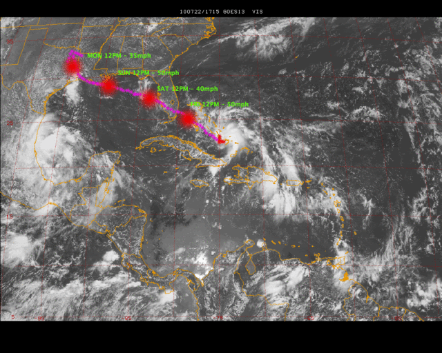
<Graphic not included with this discussion>
Invest 97L is being watched for tropical development;
…Synopsis… An area of low pressure located in the vicinity of 21.5N71W was designated Invest 97L about 48 hours ago, and is beginning to develop into a mature invest. Unfortunately the Hurricane Hunters were delayed until tomorrow due to the disorganization of this system, which will limit my observations to indirect observations for the most part. 97L is a little bit better developed than yesterday at this time, and is beginning to show signs of a low level center. This LLC is only in its primitive stages and will probably relocate numerous times until the entire system develops a bit more. The exact center will not be known until the Hurricane Hunters can get into the area. The entire system is not at all stacked very well. There does seems to be an upper level anticyclone well to the NNW of this possible LLC.
…General Conditions… There may be a NOAA GIV flying around and ahead of 97L later today, but for now I will use CIMSS and Satellite observations. Current visible satellite is showing the effects of 10-20kt shear transversing the system blowing the cloud tops from west to east. Shear only gets stronger in in the probable forecast track of this invest. The main weather story over the state of Florida is the dry air inhibiting rain showers and heating up the peninsula. This same area of dry air should be persistent through the weekend, and may slow growth of this invest. For both of these reasons, I am going to be quite conservative with my forecast.
…Brief Forecast… Intensity is going to be the big questions with this system as the models are not handling intensity well at all. Currently the NHC pegs this invest with 30kt winds and a 1013mb pressure, which seems pretty accurate with the information that we have available. I have seen a few localized observing stations for the general area reporting 1012mb, so this might be a bit more accurate. I am currently more conservative than all of the models in that I do not think this will get up to the 35kt mark for the next 48hrs, but I do think that a Tropical Depression may close off in 24-48 hours, which should be determined by one of the recon flights on day 2. With this intensity, I am going to follow the philosophy of the BAMS, and just south of the consensus models. If 97L gets stronger than I anticipated, this track need to be moved north. With this current forecast, the peninsula of Florida will have 1-2 days with tropical weather and enhanced sea breeze interactions. I think that a minimal tropical storm is possible if the engaging shear decreases and they dry air lifts out.
Forecast Likelihoods:
Forecast Confidence: 40%
97L Cyclogenesis: 40%
Meteorology Student Jonathan -- Fact789
_____________________________________________________________
As always, please ask questions of my forecast or comment upon it. Any and all questions and comments will be taken as a constructive educational experience, and are very much welcomed. Thank You!