ATL : TROPICAL DEPRESSION BONNIE - RECON DISCUSSION
Moderator: S2k Moderators


ATL : TROPICAL DEPRESSION BONNIE - RECON DISCUSSION
This thread is for discussing what Recon finds when they investigate the storm. Feel free to ask questions in here as well!
0 likes
Personal Forecast Disclaimer:
The posts in this forum are NOT official forecast and should not be used as such. They are just the opinion of the poster and may or may not be backed by sound meteorological data. They are NOT endorsed by any professional institution or storm2k.org. For official information, please refer to the NHC and NWS products
The posts in this forum are NOT official forecast and should not be used as such. They are just the opinion of the poster and may or may not be backed by sound meteorological data. They are NOT endorsed by any professional institution or storm2k.org. For official information, please refer to the NHC and NWS products


We have the Gulfstream plane flying into the system.
0 likes
Personal Forecast Disclaimer:
The posts in this forum are NOT official forecast and should not be used as such. They are just the opinion of the poster and may or may not be backed by sound meteorological data. They are NOT endorsed by any professional institution or storm2k.org. For official information, please refer to the NHC and NWS products
The posts in this forum are NOT official forecast and should not be used as such. They are just the opinion of the poster and may or may not be backed by sound meteorological data. They are NOT endorsed by any professional institution or storm2k.org. For official information, please refer to the NHC and NWS products
-
cycloneye

- Admin

- Posts: 149583
- Age: 69
- Joined: Thu Oct 10, 2002 10:54 am
- Location: San Juan, Puerto Rico
Re: ATL : INVEST 97L - RECON DISCUSSION
I dont know if we can get some data to interpret as this mission is different from the normal air force mission that flies low to see if there is a close circulation. This one is surveying the upper atmosphere and the data goes to feed the models later tonight at the 00z package.
0 likes
Visit the Caribbean-Central America Weather Thread where you can find at first post web cams,radars
and observations from Caribbean basin members Click Here
and observations from Caribbean basin members Click Here

Re: ATL : INVEST 97L - RECON DISCUSSION
cycloneye wrote:I dont know if we can get some data to interpret as this mission is different from the normal air force mission that flies low to see if there is a close circulation. This one is surveying the upper atmosphere and the data goes to feed the models later tonight at the 00z package.
when we get to drop 15 I will post the interpretation from tropicalatlantic.com.
I think that drop is the start of the circle around the area of interest.
0 likes


-
cycloneye
- Admin
- Posts: 149583
- Age: 69
- Joined: Thu Oct 10, 2002 10:54 am
- Location: San Juan, Puerto Rico
Re: ATL : INVEST 97L - RECON DISCUSSION
artist, anything of relevance so far from this mission?
0 likes
Visit the Caribbean-Central America Weather Thread where you can find at first post web cams,radars
and observations from Caribbean basin members Click Here
and observations from Caribbean basin members Click Here

Re: ATL : INVEST 97L - RECON DISCUSSION
Anyone care to discuss significance of these latest dropsonde readings?
Product: NOAA Temp Drop (Dropsonde) Message (UZNT13 KWBC)
Transmitted: 21st day of the month at 22:25Z
Aircraft: Gulfstream IV-SP (G-IV) (Reg. Num. N49RF)
Mission Purpose: Investigate second suspect area (flight in the North Atlantic basin)
Mission Number: 1
Observation Number: 20
Part A...
Date: Near the closest hour of 22Z on the 21st day of the month
Highest Mandatory Level For Which Wind Was Reported: 200mb
Coordinates: 19.7N 69.4W
Location: 90 miles (145 km) to the NNE (21°) from Santo Domingo, Dominican Republic.
Marsden Square: 043 (About)
Level Geo. Height Air Temp. Dew Point Wind Direction Wind Speed
1012mb (29.88 inHg) Sea Level (Surface) 26.0°C (78.8°F) 23.0°C (73.4°F) 150° (from the SSE) 16 knots (18 mph)
1000mb 109m (358 ft) 25.8°C (78.4°F) 21.7°C (71.1°F) 155° (from the SSE) 17 knots (20 mph)
925mb 793m (2,602 ft) 22.2°C (72.0°F) Approximately 17°C (63°F) 155° (from the SSE) 21 knots (24 mph)
850mb 1,524m (5,000 ft) 18.0°C (64.4°F) 14.5°C (58.1°F) 150° (from the SSE) 16 knots (18 mph)
700mb 3,164m (10,381 ft) 9.0°C (48.2°F) 6.2°C (43.2°F) 170° (from the S) 13 knots (15 mph)
500mb 5,880m (19,291 ft) -4.9°C (23.2°F) -6.0°C (21.2°F) 205° (from the SSW) 12 knots (14 mph)
400mb 7,600m (24,934 ft) -14.7°C (5.5°F) -16.8°C (1.8°F) 180° (from the S) 14 knots (16 mph)
300mb 9,720m (31,890 ft) -29.7°C (-21.5°F) -32.9°C (-27.2°F) 180° (from the S) 14 knots (16 mph)
250mb 10,990m (36,056 ft) -40.1°C (-40.2°F) -43.7°C (-46.7°F) 185° (from the S) 14 knots (16 mph)
200mb 12,470m (40,912 ft) -53.1°C (-63.6°F) Approximately -62°C (-80°F) 215° (from the SW) 9 knots (10 mph)
Information About Radiosonde:
- Launch Time: 22:04Z
- About Sonde: A descending radiosonde tracked automatically by satellite navigation with no solar or infrared correction.
Remarks Section...
Splash Location: 19.74N 69.37W
Splash Time: 22:18Z
Release Location: 19.69N 69.37W View map)
Release Time: 22:04:05Z
Splash Location: 19.74N 69.37W (
Splash Time: 22:18:34Z
Mean Boundary Level Wind (mean wind in the lowest 500 geopotential meters of the sounding):
- Wind Direction: 155° (from the SSE)
- Wind Speed: 19 knots (22 mph)
Deep Layer Mean Wind (average wind over the depth of the sounding):
- Wind Direction: 175° (from the S)
- Wind Speed: 12 knots (14 mph)
- Depth of Sounding: From 151mb to 1012mb
Average Wind Over Lowest Available 150 geopotential meters (gpm) of the sounding:
- Lowest 150m: 157 gpm - 7 gpm (515 geo. feet - 23 geo. feet)
- Wind Direction: 155° (from the SSE)
- Wind Speed: 17 knots (20 mph)
Sounding Software Version: AEV 20802
Are there any bullet points that can tell us the real nature of Invest 97L?
I see temperature readings for various levels. Is there anything remarkable about the difference between uppermost temps and temps close to the surface that can tell us about potential for system development.
I'm trying to get a handle on what the HDOB readings and dropsonde data combined can tell us about system potential, without entering the data into a powerful model.
I'd like to develop a better feel for the "good old-fashioned" manual method of reading synoptics.
0 likes
yeah, on my latest dropsonde winds are from:
Significant Wind Levels...
Level Wind Direction Wind Speed
1010mb (Surface) 90° (from the E) 7 knots (8 mph)
931mb 15° (from the NNE) 1 knots (1 mph)
913mb 285° (from the WNW) 10 knots (12 mph)
905mb 270° (from the W) 15 knots (17 mph)
889mb 260° (from the W) 12 knots (14 mph)
850mb 235° (from the SW) 24 knots (28 mph)
818mb 230° (from the SW) 22 knots (25 mph)
763mb 250° (from the WSW) 13 knots (15 mph)
716mb 230° (from the SW) 11 knots (13 mph)
590mb 320° (from the NW) 1 knots (1 mph)
293mb 0° (from the N) 0 knots (0 mph)
269mb 170° (from the S) 12 knots (14 mph)
250mb 155° (from the SSE) 19 knots (22 mph)
208mb 175° (from the S) 18 knots (21 mph)
186mb 150° (from the SSE) 16 knots (18 mph)
172mb 165° (from the SSE) 10 knots (12 mph)
161mb 170° (from the S) 18 knots (21 mph)
155mb 125° (from the SE) 15 knots (17 mph)
148mb 165° (from the SSE) 29 knots (33 mph)
so does this suggest anything anyone that knows? Not familiar myslef with these particular GIV flights.
0 likes
Re: ATL : INVEST 97L - RECON DISCUSSION
artist,
from my rusty studies, wind directions and intensities to give us an idea of how the system is organizing.
We can use this to understand the airflow at the low, mid and upper levels.
With this data we can build a 3-d 'image' of how the system is 'stacking' up.
When the 3 levels 'synchronize' you can call that organization.
As for the layer temps and dewpoints... that's where I get lost.
A lot came together for me once I discovered the tropical atlantic site for recon decoding.
http://www.tropicalatlantic.com/recon/
0 likes

Re: ATL : INVEST 97L - RECON DISCUSSION
tronbunny wrote:artist,
from my rusty studies, wind directions and intensities to give us an idea of how the system is organizing.
We can use this to understand the airflow at the low, mid and upper levels.
With this data we can build a 3-d 'image' of how the system is 'stacking' up.
When the 3 levels 'synchronize' you can call that organization.
As for the layer temps and dewpoints... that's where I get lost.
A lot came together for me once I discovered the tropical atlantic site for recon decoding.
http://www.tropicalatlantic.com/recon/
thanks tronbunny. Yeah, I finally have the regular flights figured out, but not these yet! lol the site you mentioned is great for all things recon, isn't it?
0 likes
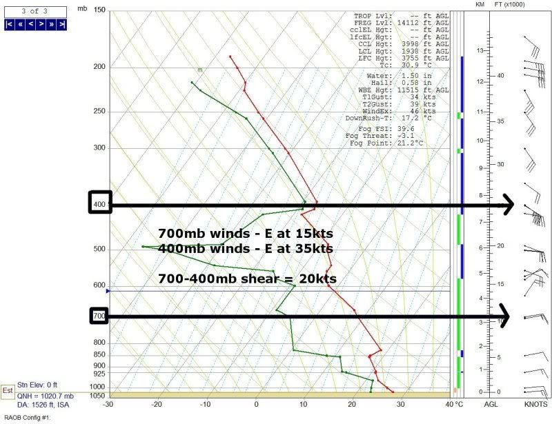
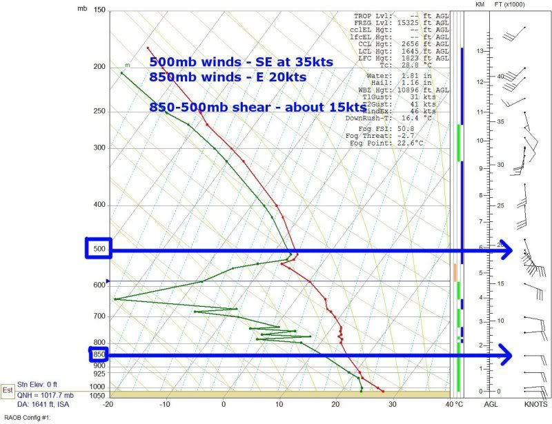
Re:
RL3AO wrote:Looks like about 15 to 30 kts shear at the 500mb level according to the skew-t's that were posted in the other thread.
Could you kindly point out exact datapoints that indicate the shear you mention?
0 likes
Re: Re:
tronbunny wrote:RL3AO wrote:Looks like about 15 to 30 kts shear at the 500mb level according to the skew-t's that were posted in the other thread.
Could you kindly point out exact datapoints that indicate the shear you mention?
Here are two examples.
BTW, I didn't look at where these dropsondes were. In fact, they could have be hundreds of miles from the invest and this doesn't mean anything.
0 likes
-
thetruesms

- Professional-Met

- Posts: 844
- Age: 42
- Joined: Thu Aug 16, 2007 1:14 pm
- Location: Tallahasee, FL
- Contact:
I wish my computer here at home wasn't 7.5 years old so it could handle Google Earth without spazzing out. It's kind of hard to keep track of so many soundings over water without having them on a map. I'll throw out general thoughts for now, though.
With the G-IV flights, it's not so much a single dropsonde that's going to reveal a whole lot about the system, but rather creating more accurate upper air maps from the network of them. From the plan, it looked like they definitely wanted to focus on the area where the ULL is to more properly get that ingested into the models - those are so tough because they spend most/all their lives in a data void, with no direct upper air measurements. The dropsondes should help out some. The ring will be good to get an idea of air flow around the system, and maybe answer some questions about the presence of an LLC. Moisture profiles would be especially important ahead of the system, to see what the area that 97L will be moving into will be like.
With the G-IV flights, it's not so much a single dropsonde that's going to reveal a whole lot about the system, but rather creating more accurate upper air maps from the network of them. From the plan, it looked like they definitely wanted to focus on the area where the ULL is to more properly get that ingested into the models - those are so tough because they spend most/all their lives in a data void, with no direct upper air measurements. The dropsondes should help out some. The ring will be good to get an idea of air flow around the system, and maybe answer some questions about the presence of an LLC. Moisture profiles would be especially important ahead of the system, to see what the area that 97L will be moving into will be like.
0 likes
Re: Re:
Thank you, RL3AO. Those are excellent examples.
I did not scrutinize those locations, either, but you gave us a good visual with those plots.
from the last 5 dropsondes, located NE, E and S of the suspect region, I saw no data supporting shear... but, in my opinion, those locations are not incredibly influential to the future of the system, at this point.
0 likes
Re:
thetruesms wrote:I wish my computer here at home wasn't 7.5 years old so it could handle Google Earth without spazzing out. It's kind of hard to keep track of so many soundings over water without having them on a map. I'll throw out general thoughts for now, though.
With the G-IV flights, it's not so much a single dropsonde that's going to reveal a whole lot about the system, but rather creating more accurate upper air maps from the network of them. From the plan, it looked like they definitely wanted to focus on the area where the ULL is to more properly get that ingested into the models - those are so tough because they spend most/all their lives in a data void, with no direct upper air measurements. The dropsondes should help out some. The ring will be good to get an idea of air flow around the system, and maybe answer some questions about the presence of an LLC. Moisture profiles would be especially important ahead of the system, to see what the area that 97L will be moving into will be like.
thanks thetruesms. I don't know if this helps you or not but here is a pic of where each set was to be taken -

0 likes
-
thetruesms
- Professional-Met
- Posts: 844
- Age: 42
- Joined: Thu Aug 16, 2007 1:14 pm
- Location: Tallahasee, FL
- Contact:
Who is online
Users browsing this forum: No registered users and 53 guests