
ATL: TROPICAL DEPRESSION BONNIE - DISCUSSION
Moderator: S2k Moderators
-
SouthFloridawx

- S2K Supporter

- Posts: 8346
- Age: 47
- Joined: Tue Jul 26, 2005 1:16 am
- Location: Sarasota, FL
- Contact:
Re: ATL: INVEST 97L - DISCUSSION
Looking at the current steering flow, I think a WNW to NW track will be in order. (290 - 300)
0 likes
-
caneman
Re:
Stormcenter wrote:Classified TS or not it's still a sheared mess.
http://www.ssd.noaa.gov/goes/flt/t1/loop-avn.html
You would be much better off looking at WV. It is clear the ULL is moving off rapidy. Sometimes I think we all need to step away from the computer once in awhile to see the bigger picture. I hadn't looked at this since last night and then again at 4AM tis morning. There is a clear improvement in the look of it, features, conditions, etc.. Wouldn't be surprised to see a T.S. today.
0 likes


Re: ATL: INVEST 97L - DISCUSSION
Will the models shift back north now? That is the question.
0 likes

Re: ATL: INVEST 97L - DISCUSSION
SouthFloridawx wrote:Looking at the current steering flow, I think a WNW to NW track will be in order. (290 - 300)
Need to remember to try to take out the effects on that wind field of the system itself. That little bow in the area of the system is being caused by the system itself, and doesn't play into the steering of the system.
Someone please correct me if I'm wrong, because I thought I remember someone saying that before.
0 likes
-
AdamFirst

- S2K Supporter
- Posts: 2490
- Age: 36
- Joined: Thu Aug 14, 2008 10:54 am
- Location: Port Saint Lucie, FL
Re: ATL: INVEST 97L - DISCUSSION
Zadok wrote:Will the models shift back north now? That is the question.
I think they're guaranteed to. I'm not speculating where but South Florida seems to be back in the crosshairs
(this is my amateur opinion and not an official forecast, etc.)
0 likes
Dolphins Marlins Canes Golden Panthers HEAT
Andrew 1992 - Irene 1999 - Frances 2004 - Jeanne 2004 - Wilma 2005 - Fay 2008 - Isaac 2012 - Matthew 2016 - Irma 2017 - Dorian 2019 - Ian 2022 - Nicole 2022 - Milton 2024
Andrew 1992 - Irene 1999 - Frances 2004 - Jeanne 2004 - Wilma 2005 - Fay 2008 - Isaac 2012 - Matthew 2016 - Irma 2017 - Dorian 2019 - Ian 2022 - Nicole 2022 - Milton 2024
-
Cryomaniac
- Category 5

- Posts: 1289
- Joined: Tue Aug 15, 2006 2:26 pm
- Location: Newark, Nottinghamshire, UK
- Contact:
Re: ATL: INVEST 97L - DISCUSSION
poof121 wrote:SouthFloridawx wrote:Looking at the current steering flow, I think a WNW to NW track will be in order. (290 - 300)
Need to remember to try to take out the effects on that wind field of the system itself. That little bow in the area of the system is being caused by the system itself, and doesn't play into the steering of the system.
Someone please correct me if I'm wrong, because I thought I remember someone saying that before.
I have absolutely no idea, but it would certainly make sense.
0 likes
-
thetruesms

- Professional-Met

- Posts: 844
- Age: 42
- Joined: Thu Aug 16, 2007 1:14 pm
- Location: Tallahasee, FL
- Contact:
Re: ATL: INVEST 97L - DISCUSSION
The immediate area around the storm is deformed, yes. Also, he's looking through way too thick a layer - you need a major to be looking at those steering currents. This would be a bit more appropriate:poof121 wrote:SouthFloridawx wrote:Looking at the current steering flow, I think a WNW to NW track will be in order. (290 - 300)
Need to remember to try to take out the effects on that wind field of the system itself. That little bow in the area of the system is being caused by the system itself, and doesn't play into the steering of the system.
Someone please correct me if I'm wrong, because I thought I remember someone saying that before.

0 likes
Punch me in the stomach or kick me in the shins (lol), but I'm not very impressed over a weak and broad circulation to the west of the convection:
http://www.ssd.noaa.gov/goes/flt/t1/flash-vis.html
http://www.ssd.noaa.gov/goes/flt/t1/flash-vis.html
0 likes
-
HURAKAN

- Professional-Met
- Posts: 46084
- Age: 39
- Joined: Thu May 20, 2004 4:34 pm
- Location: Key West, FL
- Contact:
Re: ATL: INVEST 97L - DISCUSSION
Tropical depression forming over the Bahamas
Posted by: JeffMasters, 1:29 PM GMT on July 22, 2010
A tropical wave (Invest 97L) over the eastern Bahama Islands has developed a closed circulation at the surface, and has become a tropical depression or tropical storm. Here is the text of the Special Tropical Weather Outlook from NHC at 8:25am EDT today:
Visible satellite images and observations from the Bahamas indicate that the area of low pressure in the southeastern Bahamas has become better organized and a closed circulation has formed. Advisories on a tropical depression or a tropical storm will be initiated at 11 am EDT...1500 UTC today. This advisory will likely include tropical storm watches and warnings for portions of the Bahamas and southern Florida.
Satellite images of 97L show a modest area of heavy thunderstorms that have slowly increased in intensity and areal coverage this morning. Water vapor satellite loops show a large area of dry air lies to the west of 97L, over Florida. This dry air is associated with a large upper-level low pressure system that is moving west at about the same speed 97L is. The counter-clockwise flow of air around the upper low is bringing about 20 knots of wind shear to 97L. Surface observations in the Bahamas and several nearby ships have shown top winds in 97L of up to 35 mph, so the storm is close to the 40 mph winds needed to be classified as a tropical storm.
Track Forecast for 97L
The storm is in a fairly straightforward steering current environment, and 97L should progress steadily to the west to west-northwest through Saturday. This will bring the storm ashore over the Florida Keys or South Florida on Friday, and into the Gulf of Mexico on Saturday. The latest set of model runs from 2am EDT (6Z) had the advantage of having data from a flight of the NOAA jet last night, so we have higher confidence than usual in the track of 97L over the next two days. The location of 97L's final landfall along the Gulf of Mexico coast has the usual uncertainties for 3 - 4 days, with the various models calling for landfall somewhere between the upper Texas coast and the Florida Panhandle coast. Given the uncertainties, the move halt operations in the Deepwater Horizon blowout recovery effort are probably wise.
Intensity Forecast for 97L
The primary detriment to development of 97L for the next three days will be the presence of the large upper-level low to its west. As long as this low remains in its present location, relative to 97L, it will bring wind shear of about 20 knots and dry air into the storm. This will limit the intensification potential of 97L to no more than about 10 - 20 mph per day. If the upper-level low picks up speed and pulls away from 97L, the storm may be able to intensify at a faster rate. None of the computer models is calling for that to happen, but it is possible. I put the odds of 97L making it to hurricane strength in the Gulf of Mexico at 20%.
Last edited by cycloneye on Thu Jul 22, 2010 8:38 am, edited 1 time in total.
Reason: To remove link that goes to a blogforum
Reason: To remove link that goes to a blogforum
0 likes
-
SouthFloridawx
- S2K Supporter
- Posts: 8346
- Age: 47
- Joined: Tue Jul 26, 2005 1:16 am
- Location: Sarasota, FL
- Contact:
Re: ATL: INVEST 97L - DISCUSSION
You know what, you're right. I was look at the 200-700mb. I thought I had clicked on the 250-850... My fault. Still thinking WNW though..
0 likes
-
AdamFirst
- S2K Supporter
- Posts: 2490
- Age: 36
- Joined: Thu Aug 14, 2008 10:54 am
- Location: Port Saint Lucie, FL
Re: ATL: INVEST 97L - DISCUSSION
Shear rapidly decreasing
0 likes
Dolphins Marlins Canes Golden Panthers HEAT
Andrew 1992 - Irene 1999 - Frances 2004 - Jeanne 2004 - Wilma 2005 - Fay 2008 - Isaac 2012 - Matthew 2016 - Irma 2017 - Dorian 2019 - Ian 2022 - Nicole 2022 - Milton 2024
Andrew 1992 - Irene 1999 - Frances 2004 - Jeanne 2004 - Wilma 2005 - Fay 2008 - Isaac 2012 - Matthew 2016 - Irma 2017 - Dorian 2019 - Ian 2022 - Nicole 2022 - Milton 2024
-
Aric Dunn
- Category 5
- Posts: 21238
- Age: 43
- Joined: Sun Sep 19, 2004 9:58 pm
- Location: Ready for the Chase.
- Contact:
Re: ATL: INVEST 97L - DISCUSSION
thetruesms wrote:The immediate area around the storm is deformed, yes. Also, he's looking through way too thick a layer - you need a major to be looking at those steering currents. This would be a bit more appropriate:poof121 wrote:SouthFloridawx wrote:Looking at the current steering flow, I think a WNW to NW track will be in order. (290 - 300)
Need to remember to try to take out the effects on that wind field of the system itself. That little bow in the area of the system is being caused by the system itself, and doesn't play into the steering of the system.
Someone please correct me if I'm wrong, because I thought I remember someone saying that before.
right and there is a slight weakness is the ridge there it is moving into. So this coupled with the center fix and stronger significantly stronger system then a open wave the models should respond with a slight northward shift in the short term and likely more in the long term.
0 likes
-
AdamFirst
- S2K Supporter
- Posts: 2490
- Age: 36
- Joined: Thu Aug 14, 2008 10:54 am
- Location: Port Saint Lucie, FL
Re:
Frank2 wrote:Punch me in the stomach or kick me in the shins (lol), but I'm not very impressed over a weak and broad circulation to the west of the convection:
http://www.ssd.noaa.gov/goes/flt/t1/flash-vis.html
That's not the storm's center.
0 likes
Dolphins Marlins Canes Golden Panthers HEAT
Andrew 1992 - Irene 1999 - Frances 2004 - Jeanne 2004 - Wilma 2005 - Fay 2008 - Isaac 2012 - Matthew 2016 - Irma 2017 - Dorian 2019 - Ian 2022 - Nicole 2022 - Milton 2024
Andrew 1992 - Irene 1999 - Frances 2004 - Jeanne 2004 - Wilma 2005 - Fay 2008 - Isaac 2012 - Matthew 2016 - Irma 2017 - Dorian 2019 - Ian 2022 - Nicole 2022 - Milton 2024

Re: ATL: INVEST 97L - DISCUSSION
This is getting exciting, I know is still a sheared system but I think it's exciting because of the uncertainty with intensity and track and now that we have a real system the model will get a better idea of what to do with it, I hope that it doesn't cause much trouble in the Gulf but can't help to find it interesting.
0 likes
-
Bocadude85

- Category 5
- Posts: 2991
- Age: 39
- Joined: Mon Apr 18, 2005 2:20 pm
- Location: Honolulu,Hi
Re: ATL: INVEST 97L - DISCUSSION
I am thinking this thing will hit Cuba before Florida... looks to be heading due west to me
http://www.ssd.noaa.gov/goes/flt/t1/flash-vis.html
http://www.ssd.noaa.gov/goes/flt/t1/flash-vis.html
0 likes
-
Stormcenter
- S2K Supporter
- Posts: 6689
- Joined: Wed Sep 03, 2003 11:27 am
- Location: Houston, TX
Re: Re:
Looking at the latest Water Vapor loop you can clearly see that 97L (soon to be TD or TS)is following the huge ULL into the GOM. The shear is still there and more then likely still be there
when it makes it into the GOM. IMO
http://www.ssd.noaa.gov/goes/east/carb/loop-wv.html
when it makes it into the GOM. IMO
http://www.ssd.noaa.gov/goes/east/carb/loop-wv.html
caneman wrote:Stormcenter wrote:Classified TS or not it's still a sheared mess.
http://www.ssd.noaa.gov/goes/flt/t1/loop-avn.html
You would be much better off looking at WV. It is clear the ULL is moving off rapidy. Sometimes I think we all need to step away from the computer once in awhile to see the bigger picture. I hadn't looked at this since last night and then again at 4AM tis morning. There is a clear improvement in the look of it, features, conditions, etc.. Wouldn't be surprised to see a T.S. today.
0 likes
-
StormClouds63
- Category 2

- Posts: 583
- Age: 62
- Joined: Tue May 13, 2008 11:56 am
- Location: Southwest Louisiana
Re: ATL: INVEST 97L - DISCUSSION
I have to admit it is looking better than last night ... it's still a sheared mess, but there are finally some signs of organization on the visible satellite this morning.
2 critical questions for this system:
Does it interact with land (S FLA) or pass through the straits?
What is the shear forecast for the GOM early next week?
We may have a TS in the GOM, but is the upper air environment conducive for any further strengthening? Yesterday, the New Orleans NWS commented that 97L would encounter a lot of shear in the GOM.
This is taken from the Lake Charles NWS discussion early this morning:
333 AM CDT THU JUL 22 2010
DISCUSSION...
.. OUR CURRENT THINKING IS THE LOCAL IMPACT WILL BE MAINLY ENHANCED RAIN CHANCES. WIND SHEAR FROM THE UPPER LEVEL LOW NEAR SOUTH FLORIDA IS CURRENTLY HINDERING DEVELOPMENT OF THIS SYSTEM...AND THAT MAY HOLD TRUE AS IT MOVES WEST-NORTHWEST ACROSS THE GULF THIS WEEKEND.
0 likes

Re: ATL: INVEST 97L - DISCUSSION
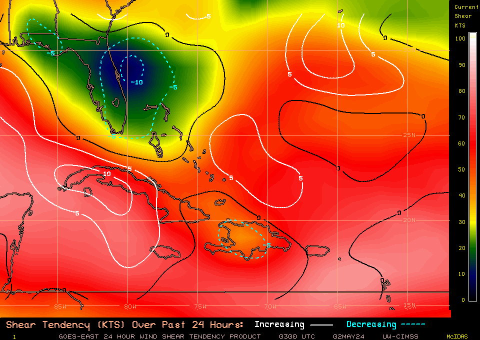
This mornings shear tendency map.
12 hrs, ago
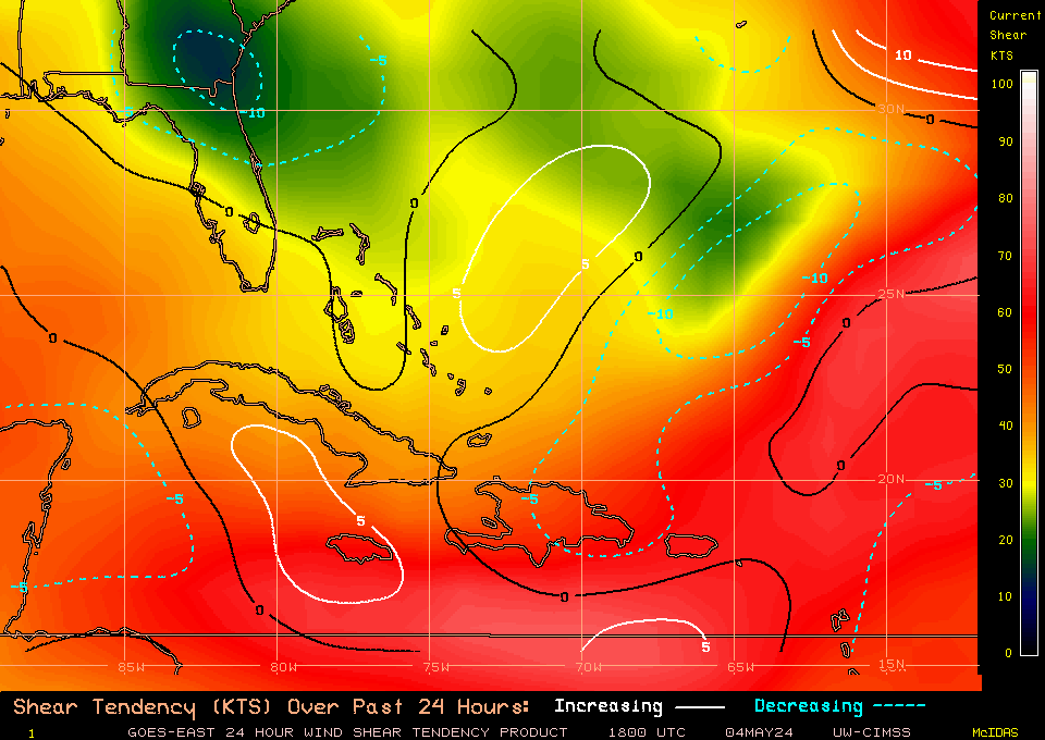
Yesterday's or 24hrs ago
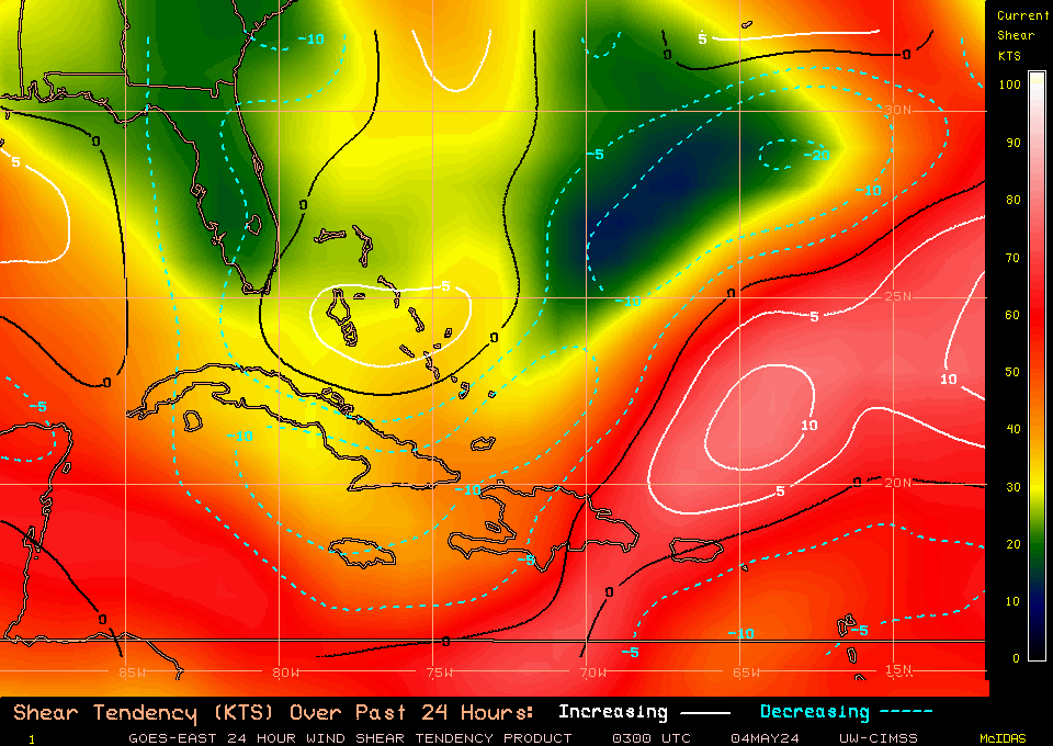
12 hrs, ago
Yesterday's or 24hrs ago
Last edited by tailgater on Thu Jul 22, 2010 8:40 am, edited 1 time in total.
0 likes
The following post is NOT an official forecast and should not be used as such. It is just the opinion of the poster and may or may not be backed by sound meteorological data. It is NOT endorsed by any professional institution including storm2k.org For Official Information please refer to the NHC and NWS products.
-
Stormcenter
- S2K Supporter
- Posts: 6689
- Joined: Wed Sep 03, 2003 11:27 am
- Location: Houston, TX
Re:
I agree based on what I'm seeing on satellite right now.
Frank2 wrote:Punch me in the stomach or kick me in the shins (lol), but I'm not very impressed over a weak and broad circulation to the west of the convection:
http://www.ssd.noaa.gov/goes/flt/t1/flash-vis.html
0 likes
Who is online
Users browsing this forum: No registered users and 51 guests