
Well you'd think so in theory but the tropics sure are complicated, the upper flow couldf well remain stagnant in front of 90L whilst the waves slowly catch up with the ULL...
One thing that is obvious at the moment, there is some very high easterly shear over the E.African wave, between 30-40kts at the moment though thats not quite as destructive as other shear.
ATL : INVEST 90L - DISCUSSION
Moderator: S2k Moderators
0 likes
Personal Forecast Disclaimer:
The posts in this forum are NOT official forecast and should not be used as such. They are just the opinion of the poster and may or may not be backed by sound meteorological data. They are NOT endorsed by any professional institution or storm2k.org. For official information, please refer to the NHC and NWS products
The posts in this forum are NOT official forecast and should not be used as such. They are just the opinion of the poster and may or may not be backed by sound meteorological data. They are NOT endorsed by any professional institution or storm2k.org. For official information, please refer to the NHC and NWS products

Re:
thetruesms wrote:People still bother watching TWC?There's almost nothing on there you can't get better or faster online
Are you kidding? Nothing beats watching Cantore and Bettes getting blown over by 100 mph gusts.

0 likes
-
cycloneye

- Admin

- Posts: 149583
- Age: 69
- Joined: Thu Oct 10, 2002 10:54 am
- Location: San Juan, Puerto Rico
Re: ATL : INVEST 90L - DISCUSSION
Ok folks,I think the topic of this thread is 90L, not TWC.
0 likes
Visit the Caribbean-Central America Weather Thread where you can find at first post web cams,radars
and observations from Caribbean basin members Click Here
and observations from Caribbean basin members Click Here
Yeah, the track was about the same as the 00z run which had a much stronger system as well.
Doesn't look like conditions will be that good aloft for development afterall once past 96hrs time but still time for things to change in that respect.
Doesn't look like conditions will be that good aloft for development afterall once past 96hrs time but still time for things to change in that respect.
0 likes
Personal Forecast Disclaimer:
The posts in this forum are NOT official forecast and should not be used as such. They are just the opinion of the poster and may or may not be backed by sound meteorological data. They are NOT endorsed by any professional institution or storm2k.org. For official information, please refer to the NHC and NWS products
The posts in this forum are NOT official forecast and should not be used as such. They are just the opinion of the poster and may or may not be backed by sound meteorological data. They are NOT endorsed by any professional institution or storm2k.org. For official information, please refer to the NHC and NWS products
-
hurricaneCW
- Category 5

- Posts: 1799
- Joined: Wed Mar 03, 2010 6:20 am
- Location: Toms River, NJ
Re: ATL : INVEST 90L - DISCUSSION
I still have a feeling that we may have to wait until August 10th at the earliest before we can get something going. The good news is that the ITCZ is really heating up so that's eliminating the dry conditions, but it's not so great aloft. It's almost as if the La Nina is still kind of lagging behind, and the shear is a bit higher than I would expect.
0 likes
-
Aric Dunn
- Category 5
- Posts: 21238
- Age: 43
- Joined: Sun Sep 19, 2004 9:58 pm
- Location: Ready for the Chase.
- Contact:
Re:
KWT wrote:Yeah, the track was about the same as the 00z run which had a much stronger system as well.
Doesn't look like conditions will be that good aloft for development afterall once past 96hrs time but still time for things to change in that respect.
well I dont think it will be an issues since all the models are too fast ...
0 likes
Re: Re:
Aric Dunn wrote:
well I dont think it will be an issues since all the models are too fast ...
If that was the case then yeah you may well be right but the combo of low level strong easterlies combined with even weak ULL set-up will play havoc with a developing system, so its a wait and see game still for sure!
All depends on how fast the upper flow is moving as well compared with the lower flow, at least this one isn't going anywhere fast, hopefully for this system the ULL can get moving.
0 likes
Personal Forecast Disclaimer:
The posts in this forum are NOT official forecast and should not be used as such. They are just the opinion of the poster and may or may not be backed by sound meteorological data. They are NOT endorsed by any professional institution or storm2k.org. For official information, please refer to the NHC and NWS products
The posts in this forum are NOT official forecast and should not be used as such. They are just the opinion of the poster and may or may not be backed by sound meteorological data. They are NOT endorsed by any professional institution or storm2k.org. For official information, please refer to the NHC and NWS products
-
HURAKAN

- Professional-Met

- Posts: 46084
- Age: 39
- Joined: Thu May 20, 2004 4:34 pm
- Location: Key West, FL
- Contact:
Re: Re:
Aric Dunn wrote:HURAKAN wrote:Not excited yet. More sit and wait is necessary!!!
yes at least 36 hours..
It's typical from this systems. If I ever had a wish granted, in the list would be to have all the systems that eventually organize, to do it quick!!! But I think billions of dollars are at the top of the wish list!!!
0 likes
-
cycloneye
- Admin
- Posts: 149583
- Age: 69
- Joined: Thu Oct 10, 2002 10:54 am
- Location: San Juan, Puerto Rico
Re: Re:
Aric Dunn wrote:HURAKAN wrote:Not excited yet. More sit and wait is necessary!!!
yes at least 36 hours..
Just on time the calender jumps to August
0 likes
Visit the Caribbean-Central America Weather Thread where you can find at first post web cams,radars
and observations from Caribbean basin members Click Here
and observations from Caribbean basin members Click Here
-
StormClouds63
- Category 2

- Posts: 583
- Age: 62
- Joined: Tue May 13, 2008 11:56 am
- Location: Southwest Louisiana
Re: ATL : INVEST 90L - DISCUSSION
So far in 2010, one has to have a great deal of patience watching and waiting for these systems to either develop or not. The phrase "conditions favor rapid intensification" has yet to be seen this year, for sure. 90L won't break that trend.
0 likes
-
cycloneye
- Admin
- Posts: 149583
- Age: 69
- Joined: Thu Oct 10, 2002 10:54 am
- Location: San Juan, Puerto Rico
Re: ATL : INVEST 90L - DISCUSSION
Below is the latest discussion by Dr Jeff Masters about 90L and big wave behind.
Posted by: JeffMasters, 8:53 PM GMT on July 30, 2010
Invest 90L is a tropical wave in the eastern Atlantic near 10N 33W with a very limited amount of heavy thunderstorm activity but a decent amount of spin. It does not have a well-defined surface circulation, and has shown little change in organization today. CIMMS wind-shear analyses show a low amount of wind shear (5 - 10 knots) over 90L, and sea surface temperatures are a record warm 29°C. The wave currently is in a moist environment and is not being affected by the dry Saharan Air Layer (SAL) to its northwest. The disturbance has moved far enough away from the Equator to leverage the Earth's spin to help it develop. The Saharan Air Layer with its dust and dry air lurks just to the north of 90L, but the SHIPS model predicts 90L will remain far enough from the dry air over the next five days so that it will not interfere with development.
Forecast for 90L
One factor inhibiting development of 90L this week will be the Madden-Julian Oscillation (MJO.) The MJO currently favors downward motion over the tropical Atlantic, which will act to decrease the chances of tropical storm formation. The Madden-Julian oscillation is a pattern of enhanced rainfall that travels along the Equator from west to east. The pattern has a wet phase with large-scale rising air and enhanced thunderstorm activity, followed by a dry phase with large-scale sinking air and suppressed thunderstorm activity. Each cycle lasts approximately 30 - 60 days. When the Madden-Julian oscillation is in its wet phase over a hurricane-prone region, the chances for tropical storm activity are greatly increased.
Perhaps the main factor interfering with 90L's development will be the presence of the large tropical wave to the east of 90L that moved off the coast of Africa yesterday. This new wave is large enough and close enough to 90L that it will probably begin to dominate regional weather patterns this weekend, stealing away 90L's inflow of low-level moist air. The new wave may also act to bring sinking air over 90L that will tend to suppress 90L's thunderstorm activity. It may turn out that the new wave will also steal some of 90L's spin, and end up being a threat to develop itself later on this weekend.
The latest 8am EDT (12Z) model runs for 90L show very little in the way of development of the storm. The predominant track forecast takes 90L into or just north of the northern Lesser Antilles Islands about 6 - 8 days from now. Looking at climatology based on research done by Dr. Bob Hart at Florida State University,, 90L has a 19% chance of developing into a tropical cyclone by 2pm Sunday. NHC is putting these odds at 20%. Dr. Hart also has an experimental product showing that historically, about 30% of all tropical cyclones that develop at 90L's current position eventually hit land as a hurricane. Of course, 90L is not yet a tropical cyclone, and I think that the large tropical wave off the coast of Africa will kill 90L this weekend.
0 likes
Visit the Caribbean-Central America Weather Thread where you can find at first post web cams,radars
and observations from Caribbean basin members Click Here
and observations from Caribbean basin members Click Here
-
HURAKAN
- Professional-Met
- Posts: 46084
- Age: 39
- Joined: Thu May 20, 2004 4:34 pm
- Location: Key West, FL
- Contact:
Re: ATL : INVEST 90L - DISCUSSION
StormClouds63 wrote:So far in 2010, one has to have a great deal of patience watching and waiting for these systems to either develop or not. The phrase "conditions favor rapid intensification" has yet to be seen this year, for sure. 90L won't break that trend.
Alex intensified very fast but took his sweet time to develop. I think that as August grows old, development periods will become shorter.
0 likes
Re: Re:
Aric Dunn wrote:HURAKAN wrote:Not excited yet. More sit and wait is necessary!!!
yes at least 36 hours..
Yeah though even that may well be too fast, I'm thinking between 48-72hrs is the best window for this one to start developing. Looks to me like we are going to possibly have a rather short window where conditions are good for development, after that the models really don't seem too keen...but that maybe partly because they maybe a little too fast and northerly...I can well see the idea that the models are too quick with this one.
0 likes
Personal Forecast Disclaimer:
The posts in this forum are NOT official forecast and should not be used as such. They are just the opinion of the poster and may or may not be backed by sound meteorological data. They are NOT endorsed by any professional institution or storm2k.org. For official information, please refer to the NHC and NWS products
The posts in this forum are NOT official forecast and should not be used as such. They are just the opinion of the poster and may or may not be backed by sound meteorological data. They are NOT endorsed by any professional institution or storm2k.org. For official information, please refer to the NHC and NWS products
-
cycloneye
- Admin
- Posts: 149583
- Age: 69
- Joined: Thu Oct 10, 2002 10:54 am
- Location: San Juan, Puerto Rico
Re: ATL : INVEST 90L - DISCUSSION
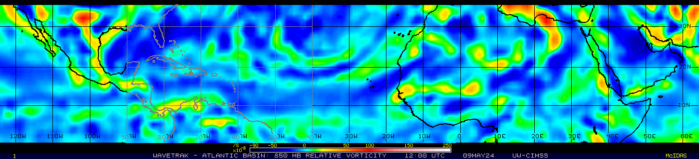
Here is a panoramic view of the players.

0 likes
Visit the Caribbean-Central America Weather Thread where you can find at first post web cams,radars
and observations from Caribbean basin members Click Here
and observations from Caribbean basin members Click Here
-
Aric Dunn
- Category 5
- Posts: 21238
- Age: 43
- Joined: Sun Sep 19, 2004 9:58 pm
- Location: Ready for the Chase.
- Contact:
Re: Re:
KWT wrote:Aric Dunn wrote:HURAKAN wrote:Not excited yet. More sit and wait is necessary!!!
yes at least 36 hours..
Yeah though even that may well be too fast, I'm thinking between 48-72hrs is the best window for this one to start developing. Looks to me like we are going to possibly have a rather short window where conditions are good for development, after that the models really don't seem too keen...but that maybe partly because they maybe a little too fast and northerly...I can well see the idea that the models are too quick with this one.
the 36hrs was for the merging ...
0 likes
Ah ok fair enough Aric, the GFS doesn't really complete that process till about 60-72hrs, which is probably the best shot at development looking at predicted conditions.
The latest GFS only really hints at development and nothing more this run...
The latest GFS only really hints at development and nothing more this run...
0 likes
Personal Forecast Disclaimer:
The posts in this forum are NOT official forecast and should not be used as such. They are just the opinion of the poster and may or may not be backed by sound meteorological data. They are NOT endorsed by any professional institution or storm2k.org. For official information, please refer to the NHC and NWS products
The posts in this forum are NOT official forecast and should not be used as such. They are just the opinion of the poster and may or may not be backed by sound meteorological data. They are NOT endorsed by any professional institution or storm2k.org. For official information, please refer to the NHC and NWS products
Who is online
Users browsing this forum: No registered users and 40 guests