
ATL: Ex COLIN - Models
Moderator: S2k Moderators

Re: ATL: INVEST 91L - MODELS
ok well this has been a hoot and all but time to hit the sack.......
talk to you guys and gals tomorrow.......Ivan get some rest bro....you are going to need it...
talk to you guys and gals tomorrow.......Ivan get some rest bro....you are going to need it...
0 likes
-
ConvergenceZone
.gif)
- Category 5

- Posts: 5241
- Joined: Fri Jul 29, 2005 1:40 am
- Location: Northern California
-
Ivanhater

- Storm2k Moderator

- Posts: 11221
- Age: 39
- Joined: Fri Jul 01, 2005 8:25 am
- Location: Pensacola
Re: ATL: INVEST 91L - MODELS
ROCK wrote:ok well this has been a hoot and all but time to hit the sack.......
talk to you guys and gals tomorrow.......Ivan get some rest bro....you are going to need it...
I hear ya..I'm about to crash
Models will change in the long range, but unfortunately the NE Islands seem to be looking at a strong system.
0 likes
Michael

The UKMO is not that different for the first 96hrs just the UKMO starts this system out at around 12-13N in 24hrs time and drags it WNW...if it started down at 11N for example we'd see a NE Caribbean brush at least.
We do have near total model agreement for Colin now though...
We do have near total model agreement for Colin now though...
0 likes
Personal Forecast Disclaimer:
The posts in this forum are NOT official forecast and should not be used as such. They are just the opinion of the poster and may or may not be backed by sound meteorological data. They are NOT endorsed by any professional institution or storm2k.org. For official information, please refer to the NHC and NWS products
The posts in this forum are NOT official forecast and should not be used as such. They are just the opinion of the poster and may or may not be backed by sound meteorological data. They are NOT endorsed by any professional institution or storm2k.org. For official information, please refer to the NHC and NWS products
Re:
ConvergenceZone wrote:Wow! what a difference 24 hours can make!!
Yeah sure does, the ECM is amazing, man that is a Rita reduex that is on that run!
0 likes
Personal Forecast Disclaimer:
The posts in this forum are NOT official forecast and should not be used as such. They are just the opinion of the poster and may or may not be backed by sound meteorological data. They are NOT endorsed by any professional institution or storm2k.org. For official information, please refer to the NHC and NWS products
The posts in this forum are NOT official forecast and should not be used as such. They are just the opinion of the poster and may or may not be backed by sound meteorological data. They are NOT endorsed by any professional institution or storm2k.org. For official information, please refer to the NHC and NWS products
-
Ivanhater
- Storm2k Moderator
- Posts: 11221
- Age: 39
- Joined: Fri Jul 01, 2005 8:25 am
- Location: Pensacola
Re: ATL: INVEST 91L - MODELS
BTW, the CANADIAN is not a fish..the long range pushes it back west under a ridge

0 likes
Michael
-
South Texas Storms

- Professional-Met

- Posts: 4261
- Joined: Thu Jun 24, 2010 12:28 am
- Location: Houston, TX
Re: ATL: INVEST 91L - MODELS
ooh man its going to be a very fun and exciting august-october!
0 likes
-
TwisterFanatic

- Category 5
- Posts: 1041
- Joined: Mon Jun 28, 2010 12:43 pm
- Location: Sallisaw, Oklahoma
The CMC is much stronger from last run also.... I think
0 likes
Personal Forecast Disclaimer:
The posts in this forum are NOT official forecast and should not be used as such. They are just the opinion of the poster and may or may not be backed by sound meteorological data. They are NOT endorsed by any professional institution or storm2k.org. For official information, please refer to the NHC and NWS products.
The posts in this forum are NOT official forecast and should not be used as such. They are just the opinion of the poster and may or may not be backed by sound meteorological data. They are NOT endorsed by any professional institution or storm2k.org. For official information, please refer to the NHC and NWS products.
Probably would be a close sahve Ivanhater but there should be just enough of a weakness there to sweep it north before any risk of landfall...
Man this is going to be a long 2 weeks coming up I feel, still nice to see the first signs of the MJO weakening from phase 3/4 is resulting with a possible developing storm.
Also shows how quickly the models can flip around, even the Euro is prone quite often to such flips...
Man this is going to be a long 2 weeks coming up I feel, still nice to see the first signs of the MJO weakening from phase 3/4 is resulting with a possible developing storm.
Also shows how quickly the models can flip around, even the Euro is prone quite often to such flips...
0 likes
Personal Forecast Disclaimer:
The posts in this forum are NOT official forecast and should not be used as such. They are just the opinion of the poster and may or may not be backed by sound meteorological data. They are NOT endorsed by any professional institution or storm2k.org. For official information, please refer to the NHC and NWS products
The posts in this forum are NOT official forecast and should not be used as such. They are just the opinion of the poster and may or may not be backed by sound meteorological data. They are NOT endorsed by any professional institution or storm2k.org. For official information, please refer to the NHC and NWS products
-
weatherguy2
- Tropical Depression

- Posts: 72
- Joined: Sun Aug 01, 2010 2:45 am
Re: ATL: INVEST 91L - MODELS
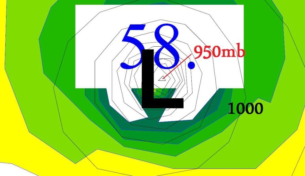
Wow 950mb on ECMWF at 240 hours at about 260 miles SSE of The Big Easy. That would be at least the typical pressure a major hurricane (Cat. 3) if true:
0 likes
Yeah, the ECM is now getting good enough resolution to see some pretty impressive pressures, but even still the true pressure would still be somewhat lower, probably 930-940 type range I'd imagine....
Lets see if the 12z run develops this time round knowing we have finally one solid Vort!
Lets see if the 12z run develops this time round knowing we have finally one solid Vort!
0 likes
Personal Forecast Disclaimer:
The posts in this forum are NOT official forecast and should not be used as such. They are just the opinion of the poster and may or may not be backed by sound meteorological data. They are NOT endorsed by any professional institution or storm2k.org. For official information, please refer to the NHC and NWS products
The posts in this forum are NOT official forecast and should not be used as such. They are just the opinion of the poster and may or may not be backed by sound meteorological data. They are NOT endorsed by any professional institution or storm2k.org. For official information, please refer to the NHC and NWS products
-
Ivanhater
- Storm2k Moderator
- Posts: 11221
- Age: 39
- Joined: Fri Jul 01, 2005 8:25 am
- Location: Pensacola
Re: ATL: INVEST 91L - MODELS
That's just one sick run

And no ridge at all in the Gulf....a long week for sure

And no ridge at all in the Gulf....a long week for sure
0 likes
Michael
-
Meridionaljet
- Tropical Wave

- Posts: 1
- Joined: Sat Jul 31, 2010 7:09 pm
-
chzzdekr81

- S2K Supporter

- Posts: 189
- Joined: Sun Aug 30, 2009 7:54 pm
- Location: Orange, Texas (SETX)
- Contact:


GFS 6Z H+120
Passing about 50-100 miles North of san Juan.
http://www.nco.ncep.noaa.gov/pmb/nwprod ... n_120l.gif
Passing about 50-100 miles North of san Juan.
http://www.nco.ncep.noaa.gov/pmb/nwprod ... n_120l.gif
0 likes
6Z GFS landfall in southern FL just north of 00z Euro..
http://www.nco.ncep.noaa.gov/pmb/nwprod ... n_228l.gif
http://www.nco.ncep.noaa.gov/pmb/nwprod ... n_228l.gif
0 likes
Who is online
Users browsing this forum: No registered users and 48 guests