

Wave East of the Windward Islands
Moderator: S2k Moderators
Forum rules

The posts in this forum are NOT official forecasts and should not be used as such. They are just the opinion of the poster and may or may not be backed by sound meteorological data. They are NOT endorsed by any professional institution or STORM2K. For official information, please refer to products from the National Hurricane Center and National Weather Service.
Re: Wave SW Cape Verde Islands
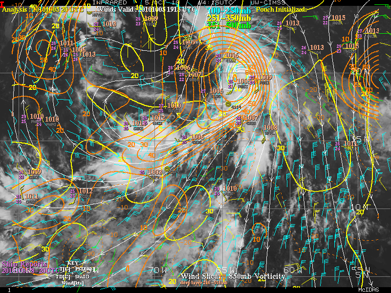
She looks better than 93L. this storm has had rotation and convection for most of its life....
0 likes


Re: Wave SW Cape Verde Islands
ConvergenceZone wrote:So before speaking about recurve or not
Sorry to sound like Carlin, but how can a wave recurve, if it hasn't curved yet?
0 likes
-
ConvergenceZone
.gif)
- Category 5

- Posts: 5241
- Joined: Fri Jul 29, 2005 1:40 am
- Location: Northern California
-
AJC3

- Admin

- Posts: 4155
- Age: 62
- Joined: Tue Aug 31, 2004 7:04 pm
- Location: Ballston Spa, New York
- Contact:
Re: Wave SW Cape Verde Islands
RL3AO wrote:ConvergenceZone wrote:So before speaking about recurve or not
Sorry to sound like Carlin, but how can a wave recurve, if it hasn't curved yet?
Over the past few years, there have been at least a couple threads where this same question was asked. A lot of peeps aren't aware that, in addition to meaning "again" the prefix "re" also means "back". Hence recurve means to "curve back", not "curve again".
0 likes


Re: Wave SW Cape Verde Islands
It has the spin so I'd watch it in case conditions suddenly improve.
0 likes
-
cycloneye

- Admin
- Posts: 149472
- Age: 69
- Joined: Thu Oct 10, 2002 10:54 am
- Location: San Juan, Puerto Rico
Re: Wave SW Cape Verde Islands
This should be a invest later today, but that is only my opinion.
0 likes
Visit the Caribbean-Central America Weather Thread where you can find at first post web cams,radars
and observations from Caribbean basin members Click Here
and observations from Caribbean basin members Click Here
-
Gustywind

- Category 5
- Posts: 12334
- Joined: Mon Sep 03, 2007 7:29 am
- Location: Baie-Mahault, GUADELOUPE
Re: Wave SW Cape Verde Islands
cycloneye wrote:This should be a invest later today, but that is only my opinion.
Why not Cycloneye?
0 likes
-
Gustywind
- Category 5
- Posts: 12334
- Joined: Mon Sep 03, 2007 7:29 am
- Location: Baie-Mahault, GUADELOUPE
From Crown Weather Discussion
Tropical Weather Discussion
Issued: Sunday, August 8, 2010 820 am EDT/720 am CDT
http://www.crownweather.com/?page_id=325
Discussion
The Long Range Prospects Look Ominous – The Atlantic Is About To Go Boom:
All of the signals are coming together with both real-time data and model guidance data that the lid is about come off in the Atlantic. The latest MJO chart found HERE shows that the upward motion pulse is now showing up in the Atlantic Basin. Basically, if you don’t want tropical storms and hurricanes, then green is bad and brown is good. The green areas are areas that have upward motion in the atmosphere which leads to storm formation. The brown areas are basically the complete opposite and are areas of downward sinking motion which suppresses storm formation.
This morning’s long range GFS model is fairly ominous. Not only does it show a train of systems developing by around August 23rd, it also shows a pattern shift that would lead to systems tracking much further west towards the US and Caribbean.
One chart that I look at sometimes is the Roundy Tropical Cyclone Formation Probability Chart. It basically forecasts the probability of a tropical cyclone to form in any one given spot out to 30 days in advance. The latest probability chart shows that the chances of tropical cyclone formation increases in the Gulf of Mexico starting on Wednesday and this is likely due to the system forecast to try and develop there this week. It also forecasts a fairly rapid increase in the chances for tropical cyclone formation east of 45 West Longitude starting around August 15th. By the last week of August and the first week of September, the Roundy chart shows much of the Atlantic in an increased chance area for tropical cyclone formation.
So, here is my thinking on this: The Saharan Air Layer is now starting to thin out and rainfall amounts across the African continent have been above average lately. Given this, I suspect that we will likely see an increase of more robust tropical disturbances coming off of the coast of Africa as we head towards mid August. The pattern shift forecast by the long range GFS model is something to really be concerned about, if it verifies. This pattern shift would leave the door open to increased threats of tropical storms and hurricanes to the Caribbean, southeastern United States and the Gulf of Mexico after August 15th to August 20th.
0 likes
-
lonelymike
- S2K Supporter

- Posts: 634
- Joined: Sat Jul 26, 2008 10:12 am
- Location: walton county fla


-
ConvergenceZone
- Category 5
- Posts: 5241
- Joined: Fri Jul 29, 2005 1:40 am
- Location: Northern California
Wow, that's an pretty ominous interesting discussion by Crown Weather. I haven't read anything on this board about the GFS showing a train of systems around August 23rd like they mentioned, so they must be seeing something that we aren't seeing. I think I may have to venture over to their website to take a look at what they are seeing.....
0 likes

Hi CZ, look at the long range model thread, I discussed what I think will happen last night and I strongly agree with Crownweather, I'm seeing some pretty beefy signals coming up, other then 94/93L I don't think much will happen in the next 10 days but after that it sure looks interesting, even more so because the models are more then hinting at a pretty strong upper high formation occuring, could easily see systems shunted towards Mexico if its too strong, but equally if it ends up far enough north, then who knows!
0 likes
Personal Forecast Disclaimer:
The posts in this forum are NOT official forecast and should not be used as such. They are just the opinion of the poster and may or may not be backed by sound meteorological data. They are NOT endorsed by any professional institution or storm2k.org. For official information, please refer to the NHC and NWS products
The posts in this forum are NOT official forecast and should not be used as such. They are just the opinion of the poster and may or may not be backed by sound meteorological data. They are NOT endorsed by any professional institution or storm2k.org. For official information, please refer to the NHC and NWS products

Re: Wave SW Cape Verde Islands
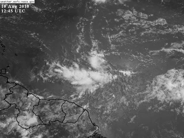
Very interesting out of africa. I think we can mark it as the next investment area.
0 likes
Re: Wave East of the Winward Islands
Of course none of that would apply if the polar jet makes an early migration southward, or the ULL's and TUTT's persist longer than usual, so before anyone starts bording up their house...
0 likes
Who knows Frank maybe the surprise this season may blow up far closer to home...
Anyway yeah I think this may well be the wave we've watching from remembering what the models did with it and tracked it. Nothing too impressive but lets wait and see what happens in the Caribbean.
Anyway yeah I think this may well be the wave we've watching from remembering what the models did with it and tracked it. Nothing too impressive but lets wait and see what happens in the Caribbean.
0 likes
Personal Forecast Disclaimer:
The posts in this forum are NOT official forecast and should not be used as such. They are just the opinion of the poster and may or may not be backed by sound meteorological data. They are NOT endorsed by any professional institution or storm2k.org. For official information, please refer to the NHC and NWS products
The posts in this forum are NOT official forecast and should not be used as such. They are just the opinion of the poster and may or may not be backed by sound meteorological data. They are NOT endorsed by any professional institution or storm2k.org. For official information, please refer to the NHC and NWS products
Who is online
Users browsing this forum: gib, Google [Bot] and 88 guests