
Coming down good now here in Larose with the occasional thunder:
http://www.wwltv.com/weather/interactiv ... map=sshore
ATL: EX-Tropical Depression FIVE - Discussion
Moderator: S2k Moderators
-
Pearl River

- S2K Supporter

- Posts: 825
- Age: 67
- Joined: Fri Dec 09, 2005 6:07 pm
- Location: SELa
Re: ATL: Ex Tropical Depression FIVE - Discussion
http://radar.weather.gov/radar.php?rid=LIX&product=N0R&overlay=11101111&loop=yes
If it's moving, it's very slow. Looks almost stationary over eastern St Bernard and Plaquemines Parishes. Lots of light shows!
If it's moving, it's very slow. Looks almost stationary over eastern St Bernard and Plaquemines Parishes. Lots of light shows!
0 likes
-
DTWright

- Tropical Low

- Posts: 37
- Age: 66
- Joined: Sun Jun 27, 2010 4:48 pm
- Location: ( AKA Sabanic ) Mobile, AL
- Contact:
Re: ATL: Ex Tropical Depression FIVE - Discussion
You can clearly see what looks to be the center just offshore, and it sure doesn't seem to be in a big hurry to go anywhere.
0 likes
-
cycloneye

- Admin

- Posts: 149620
- Age: 69
- Joined: Thu Oct 10, 2002 10:54 am
- Location: San Juan, Puerto Rico
Re: ATL: Ex Tropical Depression FIVE - Discussion
TROPICAL WEATHER OUTLOOK
NWS TPC/NATIONAL HURRICANE CENTER MIAMI FL
800 AM EDT THU AUG 12 2010
FOR THE NORTH ATLANTIC...CARIBBEAN SEA AND THE GULF OF MEXICO...
AN AREA OF LOW PRESSURE ASSOCIATED WITH THE REMNANTS OF TROPICAL
DEPRESSION FIVE IS MOVING WESTWARD OVER SOUTHEASTERN LOUISIANA...
ACCOMPANIED BY LOCALLY HEAVY RAINS AND OCCASIONALLY GUSTY WINDS IN
SQUALLS. ALTHOUGH THE CIRCULATION OF THIS SYSTEM HAS BECOME BETTER
DEFINED THIS MORNING...THE REMNANTS OF THE DEPRESSION WILL BE
MOVING FARTHER INLAND TODAY AND ADDITIONAL DEVELOPMENT IS NOT
EXPECTED. THERE IS A LOW CHANCE...NEAR 0 PERCENT...OF THIS SYSTEM
BECOMING A TROPICAL CYCLONE DURING THE NEXT 48 HOURS. LOCALIZED
FLOODING IS POSSIBLE OVER SOUTHERN LOUISIANA AND COASTAL
MISSISSIPPI...PLEASE REFER TO STATEMENTS FROM LOCAL NATIONAL
WEATHER SERVICE FORECAST OFFICES FOR ADDITIONAL INFORMATION.
CLOUDINESS AND SHOWERS ASSOCIATED WITH A TROPICAL WAVE NEARING THE
LESSER ANTILLES ARE DISORGANIZED. UPPER-LEVEL WINDS ARE FORECAST TO
BECOME UNFAVORABLE FOR DEVELOPMENT...AND THERE IS A LOW
CHANCE...NEAR 0 PERCENT...OF THIS SYSTEM BECOMING A TROPICAL
CYCLONE DURING THE NEXT 48 HOURS AS IT MOVES WEST-NORTHWESTWARD AT
15 MPH.
ELSEWHERE...TROPICAL CYCLONE FORMATION IS NOT EXPECTED DURING THE
NEXT 48 HOURS.
$$
FORECASTER CANGIALOSI
0 likes
Visit the Caribbean-Central America Weather Thread where you can find at first post web cams,radars
and observations from Caribbean basin members Click Here
and observations from Caribbean basin members Click Here
-
wxman57

- Moderator-Pro Met

- Posts: 23175
- Age: 68
- Joined: Sat Jun 21, 2003 8:06 pm
- Location: Houston, TX (southwest)
Re: ATL: Ex Tropical Depression FIVE - Discussion
Surface obs put the center inland southeast of New Orleans. It's moving northward at a fair clip - 8-10 mph.
0 likes

Re: ATL: Ex Tropical Depression FIVE - Discussion
Another system that needed land pushed back a little bit to develop? Or did it tighten up due to land friction?
0 likes
-
Stormcenter
- S2K Supporter
- Posts: 6689
- Joined: Wed Sep 03, 2003 11:27 am
- Location: Houston, TX
Re: ATL: Ex Tropical Depression FIVE - Discussion
If it's moving northward I don't see it. If anything it looks like
it's drifting WSW right across Lake Pontchartrain per WWL-TV's
radar out of New Orleans.
http://www.wwltv.com/weather/radar?rada ... &img=0&c=y
it's drifting WSW right across Lake Pontchartrain per WWL-TV's
radar out of New Orleans.
http://www.wwltv.com/weather/radar?rada ... &img=0&c=y
wxman57 wrote:Surface obs put the center inland southeast of New Orleans. It's moving northward at a fair clip - 8-10 mph.
0 likes
Re: ATL: Ex Tropical Depression FIVE - Discussion
Stormcenter wrote:If it's moving northward I don't see it. If anything it looks like
it's drifting WSW right across Lake Pontchartrain per WWL-TV's
radar out of New Orleans.
http://www.wwltv.com/weather/radar?rada ... &img=0&c=ywxman57 wrote:Surface obs put the center inland southeast of New Orleans. It's moving northward at a fair clip - 8-10 mph.
Actually, if you look at the movement of the radar echoes over the lake, they're southerly. I'd focus more on rural St. Bernard, just east of the "New Orleans" city label. Not sure of the movement though.
0 likes
-
Dean4Storms
- S2K Supporter
- Posts: 6358
- Age: 63
- Joined: Sun Aug 31, 2003 1:01 pm
- Location: Miramar Bch. FL
Re: ATL: Ex Tropical Depression FIVE - Discussion
Stormcenter wrote:If it's moving northward I don't see it. If anything it looks like
it's drifting WSW right across Lake Pontchartrain per WWL-TV's
radar out of New Orleans.
http://www.wwltv.com/weather/radar?rada ... &img=0&c=ywxman57 wrote:Surface obs put the center inland southeast of New Orleans. It's moving northward at a fair clip - 8-10 mph.
Remember with radar you are not seeing the surface low but the MLC most likely. The mid and upper levels are still being dragged westward from the remains of that ULL. This system has remained tilted and most likely why the sustained winds never really got going or the surface pressure responding with a drop.
I should add.....The ULL and the H5 Ridge over the SE USA are sending all mid level westward.
Last edited by Dean4Storms on Thu Aug 12, 2010 8:23 am, edited 1 time in total.
0 likes
-
wxman57
- Moderator-Pro Met
- Posts: 23175
- Age: 68
- Joined: Sat Jun 21, 2003 8:06 pm
- Location: Houston, TX (southwest)
Re: ATL: Ex Tropical Depression FIVE - Discussion
Stormcenter wrote:If it's moving northward I don't see it. If anything it looks like
it's drifting WSW right across Lake Pontchartrain per WWL-TV's
radar out of New Orleans.
http://www.wwltv.com/weather/radar?rada ... &img=0&c=ywxman57 wrote:Surface obs put the center inland southeast of New Orleans. It's moving northward at a fair clip - 8-10 mph.
You have to look at more than a 30 minute radar loop to detect the movement of the broad low. I'm using a 6-12 hr motion from surface obs.
0 likes
-
Dean4Storms
- S2K Supporter
- Posts: 6358
- Age: 63
- Joined: Sun Aug 31, 2003 1:01 pm
- Location: Miramar Bch. FL
-
Stormcenter
- S2K Supporter
- Posts: 6689
- Joined: Wed Sep 03, 2003 11:27 am
- Location: Houston, TX
Re:
What can you clearly see?
I was referring to what was originally south of Mobile yesterday and has tracked
westward to where it's at now. It has been and continues
to be the focus of the heavy rain this morning and is what was once TD5 per the
NHC.
I was referring to what was originally south of Mobile yesterday and has tracked
westward to where it's at now. It has been and continues
to be the focus of the heavy rain this morning and is what was once TD5 per the
NHC.
Dean4Storms wrote:You can clearly see it on WV loops.......
http://www.ssd.noaa.gov/goes/flt/t1/flash-wv.html
0 likes

Re: ATL: Ex Tropical Depression FIVE - Discussion
Don't know about surface vs aloft that close to the radar and it's not like matters much anyway rainfall will be the only threat.
this radar is almost a hour long loop and I can't really tell if moving north or west or what, not much movement at all.
http://radar.weather.gov/radar.php?prod ... x&loop=yes
this radar is almost a hour long loop and I can't really tell if moving north or west or what, not much movement at all.
http://radar.weather.gov/radar.php?prod ... x&loop=yes
0 likes
The following post is NOT an official forecast and should not be used as such. It is just the opinion of the poster and may or may not be backed by sound meteorological data. It is NOT endorsed by any professional institution including storm2k.org For Official Information please refer to the NHC and NWS products.
-
CaneCurious

- Tropical Storm

- Posts: 160
- Joined: Wed Aug 25, 2004 1:40 pm
- Location: Kenner, LA
-
tolakram
- Admin
- Posts: 20186
- Age: 62
- Joined: Sun Aug 27, 2006 8:23 pm
- Location: Florence, KY (name is Mark)
Re: ATL: Ex Tropical Depression FIVE - Discussion

0 likes
M a r k
- - - - -
Join us in chat: Storm2K Chatroom Invite. Android and IOS apps also available.
The posts in this forum are NOT official forecasts and should not be used as such. Posts are NOT endorsed by any professional institution or STORM2K.org. For official information and forecasts, please refer to NHC and NWS products.

Re: ATL: Ex Tropical Depression FIVE - Discussion
We now have the rain in Biloxi. Lots of it. Barely any wind to speak of. Streets are pooling up.
0 likes


Re: ATL: Ex Tropical Depression FIVE - Discussion
Ex TD5 is looking better than when it was named. Interesting if that convective mass to the east will get pulled into the main circulation. I believe its stationary or maybe a slow drift to the W-SW now. There is an upper level anticyclone over the main circulation center now.

0 likes
Re: ATL: Ex Tropical Depression FIVE - Discussion
Surface Obs seem to indicate a bit of a SW movement. Notice SHBL1 decreasing during the 1300 obs, increasing during the 1400 obs, but BYGL1, GISL1, and PSTL1 all decreasing slightly for the 1400 obs. Everywhere else is seeing pressure increases, meaning the low is weakening, but the slow decreases at these stations seems to indicate the low is moving in that general direction.
Please, any pro mets correct me if this analysis is wrong.
http://www.ndbc.noaa.gov/radial_search.php?lat1=30N&lon1=90W&uom=M&dist=150&ot=A&time=3
Please, any pro mets correct me if this analysis is wrong.
http://www.ndbc.noaa.gov/radial_search.php?lat1=30N&lon1=90W&uom=M&dist=150&ot=A&time=3
0 likes


-
srainhoutx

- S2K Supporter
- Posts: 6919
- Age: 68
- Joined: Sun Jan 14, 2007 11:34 am
- Location: Haywood County, NC
- Contact:
Re: ATL: Ex Tropical Depression FIVE - Discussion
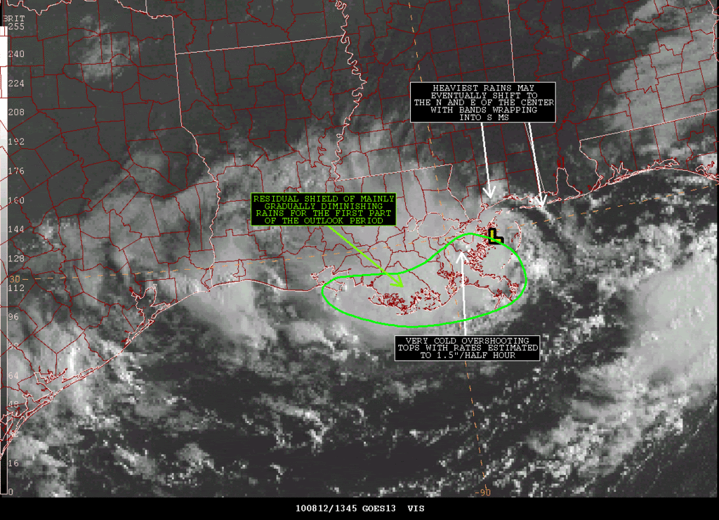
From Nesdis regarding Heavy Rainfall...
SATELLITE PRECIPITATION ESTIMATES..DATE/TIME 08/12/10 1408Z
SATELLITE ANALYSIS BRANCH/NESDIS---NPPU---TEL.301-763-8678
LATEST DATA USED: GOES-EAST:1355Z JS
.
LOCATION...S AND SE LOUISIANA...
.
ATTN WFOS...LIX...LCH...
ATTN RFCS...LMRFC...
.
EVENT...HEAVY RAIN WITH REMNANTS OF TD-5.
.
SATELLITE ANALYSIS AND TRENDS...VISIBLE SATELLITE AND COMPOSITE RADAR
ANIMATIONS INDICATE THE LOW LEVEL CENTER ASSOCIATED WITH THE REMNANTS OF
TD-5 CONTINUES TO MOVE SLOWLY TO THE WEST OR JUST SLIGHTLY NORTH OF DUE
WEST AND IS CURRENTLY CLOSE TO ENTERING EASTERN ST BERNARD PARISH. THE
HEAVIEST RAINFALL WITH THIS SYSTEM HAS BEEN ALONG THE WESTERN AND SOUTHERN
PERIPHERY OF THE CENTER WITH AUTOMATED SATELLITE ESTIMATING TECHNIQUES
SHOWING STORM TOTALS OF AT LEAST 3-4" FOR PORTIONS OF THE AREA FROM
JEFFERSON/ST CHARLES PARISHES SOUTHWARD TO E TERREBONNE/LAFOURCHE PARISHES
AND A MAX OF OVER 6" ALONG THE COAST OR JUST OFFSHORE OF PLAQUEMINES.
.
AN ANNOTATED SATELLITE GRAPHIC SHOWING HEAVY RAIN THREAT AREA SHOULD
BE AVAILABLE ON THE INTERNET ADDRESS LISTED BELOW IN APPROXIMATELY
10 MINUTES.
.
SHORT TERM OUTLOOK VALID 1400-1700Z...MEDIUM CONFIDENCE FACTOR IN SHORT
TERM OUTLOOK...BELIEVE THE HEAVIEST RAINS WILL CONTINUE TO AFFECT
S CENT AND SE LA FOR AT LEAST FOR THE FIRST HOUR OR SO OF THE SHORT
TERM PERIOD. HAVE NOTED SOME DEVELOPING VERY COLD/OVERSHOOTING TOPS IN
RECENT SATELLITE IMAGES OVER NE PLAQUEMINES PARISH JUST TO THE SW OF THE
CIRCULATION CENTER WITH INTENSE SATELLITE ESTIMATED RAIN RATES LIKELY
TO 1.5"/HALF HOUR. ELSEWHERE, CLOUD TOPS HAVE WARMED SLIGHTLY AS THE
MOST INTENSE CORES HAVE DIMINISHED IN COVERAGE, BUT SHIELD OF MODERATE
TO OCCASIONALLY HEAVIER RAINS WITH GENERAL SATELLITE ESTIMATED RATES OF
.5"-1.0"/HR AND ISOLATED RATES IN THE 1-2"/HR RANGE STRETCH ACROSS THE
SOUTHERN PORTIONS OF TERREBONNE/LAFOURCHE PARISHES. FOR THE REMAINDER
OF THE OUTLOOK PERIOD, CONFIDENCE IS MUCH LOWER WITH OVERALL WEAKENING
TREND SEEN WITH MOST OF THE CENTRAL DENSE OVERCAST COVERING S AND SE
LA. THERE IS THE POSSIBILITY THAT THE HEAVIER RAINS MAY GRADUALLY SHIFT
TO THE EAST WITH BANDS WRAPPING AROUND THE EASTERN AND NORTHERN PART OF
THE SYSTEM INTO SOUTHERN MISSISSIPPI.
0 likes
Carla/Alicia/Jerry(In The Eye)/Michelle/Charley/Ivan/Dennis/Katrina/Rita/Wilma/Ike/Harvey
Member: National Weather Association
Wx Infinity Forums
http://wxinfinity.com/index.php
Facebook.com/WeatherInfinity
Twitter @WeatherInfinity
Member: National Weather Association
Wx Infinity Forums
http://wxinfinity.com/index.php
Facebook.com/WeatherInfinity
Twitter @WeatherInfinity
Who is online
Users browsing this forum: No registered users and 51 guests