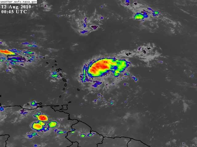
Wave East of the Windward Islands

This is the general tropical discussion area. Anyone can take their shot at predicting a storms path.

Moderator: S2k Moderators

Forum rules

The posts in this forum are NOT official forecasts and should not be used as such. They are just the opinion of the poster and may or may not be backed by sound meteorological data. They are NOT endorsed by any professional institution or STORM2K. For official information, please refer to products from the National Hurricane Center and National Weather Service.

Help Support Storm2K
Message
Author
NOLA2010
Tropical Depression
Tropical Depression
Posts: 61
Joined: Sun Jun 13, 2010 7:10 pm
Location: New Orleans

Re: Wave East of the Windward Islands

#161 Postby NOLA2010 » Wed Aug 11, 2010 4:18 pm

Florida1118 wrote:
hurricaneCW wrote:This hurricane season is starting to remind me of a mid-Atlantic winter. In order for us to get all snow, everything has to set up perfectly (last winter being the exception). The only way we'll get a hurricane is if everything is perfect, which is almost impossible in any hurricane season.

no offence to you, but you really seem to hate every single system that has formed so far and really make the mood sad feeling. :cry:


I agree. We understand that you don't see how this season is going to match all the numbers and how the conditions in the Atlantic are unfavorable right now for development. You have stated that point multiple times. It gets old after a while.
0 likes   

User avatar
HURAKAN
Professional-Met
Professional-Met
Posts: 46086
Age: 38
Joined: Thu May 20, 2004 4:34 pm
Location: Key West, FL
Contact:

Re: Wave East of the Windward Islands

#162 Postby HURAKAN » Wed Aug 11, 2010 4:46 pm

Station 41101
Meteo France
Location: 14.6N 56.201W
08/11/2010 1500 UTC
Winds: E (100°) at 4.1 kts
Significant Wave Height: 3.0 ft
Dominant Wave period: 6 sec
Atmospheric Pressure: 29.94 in and rising
Air Temperature: 82.6 °F
Dew Point: 74.3 °F
Water Temperature: 84.9 °F


this buoy is in the middle of the disturbance and pressure is rising. Looks good on the satellite images but that could be a mirage.

Image
0 likes   

User avatar
KWT
Category 5
Category 5
Posts: 31415
Joined: Tue Aug 17, 2004 11:02 am
Location: UK!!!

#163 Postby KWT » Wed Aug 11, 2010 4:53 pm

Looks good but once again the low levels look real poor, and as we have seen quite a bit if there is no low level help then any slight downward trend will make the system poof.
0 likes   
Personal Forecast Disclaimer:
The posts in this forum are NOT official forecast and should not be used as such. They are just the opinion of the poster and may or may not be backed by sound meteorological data. They are NOT endorsed by any professional institution or storm2k.org. For official information, please refer to the NHC and NWS products

User avatar
gatorcane
S2K Supporter
S2K Supporter
Posts: 23691
Age: 47
Joined: Sun Mar 13, 2005 3:54 pm
Location: Boca Raton, FL

#164 Postby gatorcane » Wed Aug 11, 2010 5:08 pm

Looking better today, maybe an invest later this evening? Need to see if the convection poofs or not. NHC may up the chances of development for the next TWO perhaps.
0 likes   

User avatar
KWT
Category 5
Category 5
Posts: 31415
Joined: Tue Aug 17, 2004 11:02 am
Location: UK!!!

#165 Postby KWT » Wed Aug 11, 2010 5:19 pm

It quite possibly will be an invest soon if it holds this current presentation...models aren't at all keen on this and they've done very well so far...
0 likes   
Personal Forecast Disclaimer:
The posts in this forum are NOT official forecast and should not be used as such. They are just the opinion of the poster and may or may not be backed by sound meteorological data. They are NOT endorsed by any professional institution or storm2k.org. For official information, please refer to the NHC and NWS products

User avatar
TheBurn
Category 2
Category 2
Posts: 540
Joined: Thu Jul 28, 2005 4:00 pm
Location: Rincon, PR

Re: Wave East of the Windward Islands

#166 Postby TheBurn » Wed Aug 11, 2010 5:47 pm

Image
0 likes   

Aric Dunn
Category 5
Category 5
Posts: 21238
Age: 42
Joined: Sun Sep 19, 2004 9:58 pm
Location: Ready for the Chase.
Contact:

#167 Postby Aric Dunn » Wed Aug 11, 2010 6:17 pm

pressure fall are going to take time.. remember the convection just started firing this evening and for something to work down to the surface of course takes time. there is a tropical wave associated with this disturbance so it needs to be watched thats for sure..
0 likes   

floridasun78
Category 5
Category 5
Posts: 3755
Joined: Sun May 17, 2009 10:16 pm
Location: miami fl

Re: Wave East of the Windward Islands

#168 Postby floridasun78 » Wed Aug 11, 2010 6:23 pm

this time on tue it was starting look like lost all storms but that not case tonight but i see shear bad north of PR
0 likes   

User avatar
gatorcane
S2K Supporter
S2K Supporter
Posts: 23691
Age: 47
Joined: Sun Mar 13, 2005 3:54 pm
Location: Boca Raton, FL

#169 Postby gatorcane » Wed Aug 11, 2010 6:27 pm

even a weak wave like this one that is so far south, the t-storm activity is going to somehow miss the Leewards it appears. What a MAJOR trough digging into the Western and Central Atlantic...looks like this wave is very fishy....

HINT: Look at what the NAM has been doing with this...misses the islands to the NE by a good margin and gets sucked into the Atlantic graveyard along with 93L.
Last edited by gatorcane on Wed Aug 11, 2010 6:31 pm, edited 1 time in total.
0 likes   

Hugo1989
Tropical Storm
Tropical Storm
Posts: 147
Joined: Mon Jun 14, 2010 9:09 am

Re: Wave East of the Windward Islands

#170 Postby Hugo1989 » Wed Aug 11, 2010 6:30 pm

It may increase your chance to 20% but I can not be anything beyond.
0 likes   

User avatar
cycloneye
Admin
Admin
Posts: 145345
Age: 68
Joined: Thu Oct 10, 2002 10:54 am
Location: San Juan, Puerto Rico

Re: Wave East of the Windward Islands

#171 Postby cycloneye » Wed Aug 11, 2010 6:34 pm

ABNT20 KNHC 112331
TWOAT
TROPICAL WEATHER OUTLOOK
NWS TPC/NATIONAL HURRICANE CENTER MIAMI FL
800 PM EDT WED AUG 11 2010

FOR THE NORTH ATLANTIC...CARIBBEAN SEA AND THE GULF OF MEXICO...

THE NATIONAL HURRICANE CENTER HAS ISSUED THE LAST ADVISORY ON
TROPICAL DEPRESSION FIVE...WHICH HAS DEGENERATED INTO A REMNANT LOW
PRESSURE AREA OVER THE NORTHERN GULF OF MEXICO. THIS LOW COULD
STILL PRODUCE LOCALLY HEAVY RAINS AND STRONG GUSTY WINDS IN SQUALLS
TO PORTIONS OF THE NORTHERN GULF OF MEXICO COAST TONIGHT AND EARLY
THURSDAY. REFER TO STATEMENTS FROM LOCAL NATIONAL WEATHER SERVICE
FORECAST OFFICES FOR ADDITIONAL INFORMATION. THE LOW IS EXPECTED
TO MOVE INLAND ALONG THE NORTH-CENTRAL GULF COAST BY EARLY THURSDAY
AND THERE IS A LOW CHANCE...NEAR 0 PERCENT...OF THIS SYSTEM
BECOMING A TROPICAL CYCLONE DURING THE NEXT 48 HOURS.

A LOW PRESSURE SYSTEM LOCATED ABOUT 850 MILES NORTHEAST OF THE
NORTHERN LEEWARD ISLANDS IS PRODUCING MINIMAL SHOWER ACTIVITY AT
THIS TIME. UPPER-LEVEL WINDS ARE NOT CONDUCIVE FOR DEVELOPMENT AND
THERE IS A LOW CHANCE...20 PERCENT...OF THIS SYSTEM BECOMING A
TROPICAL CYCLONE DURING THE NEXT 48 HOURS AS IT MOVES TOWARD THE
NORTH AND NORTH-NORTHEAST OVER THE ATLANTIC.

AN AREA OF DISORGANIZED CLOUDINESS AND SHOWERS ASSOCIATED WITH A
TROPICAL WAVE IS LOCATED ABOUT 250 MILES EAST OF THE LESSER
ANTILLES. SIGNIFICANT DEVELOPMENT OF THIS DISTURBANCE IS NOT
EXPECTED AS IT MOVES GENERALLY WEST-NORTHWESTWARD AT ABOUT 15 MPH.
THERE IS A LOW CHANCE...10 PERCENT...OF THIS SYSTEM BECOMING A
TROPICAL CYCLONE DURING THE NEXT 48 HOURS.


ELSEWHERE...TROPICAL CYCLONE FORMATION IS NOT EXPECTED DURING THE
NEXT 48 HOURS.

$$
FORECASTER PASCH/KIMBERLAIN

0 likes   
Visit the Caribbean-Central America Weather Thread where you can find at first post web cams,radars
and observations from Caribbean basin members Click Here

Aric Dunn
Category 5
Category 5
Posts: 21238
Age: 42
Joined: Sun Sep 19, 2004 9:58 pm
Location: Ready for the Chase.
Contact:

#172 Postby Aric Dunn » Wed Aug 11, 2010 6:36 pm

They cut and pasted from the 2 pm lol ... and the convection is way more organized at least it satellite appearance than td5 ever did .. lol
0 likes   

Patrick99
Category 5
Category 5
Posts: 1770
Joined: Mon May 24, 2004 3:43 pm
Location: SW Broward, FL

Re: Wave East of the Windward Islands

#173 Postby Patrick99 » Wed Aug 11, 2010 6:43 pm

I'm still a little bullish. It held together well today. It appears to be heading WNW toward the general direction of the shear.........but by the same token I'm not sure that shear will be there in the same intensity by the time it really gets to that area. It looks to me like things are changing.....looking at the WV loop, I don't think that particular ULL is going to be a player for that much longer.
0 likes   

User avatar
HURAKAN
Professional-Met
Professional-Met
Posts: 46086
Age: 38
Joined: Thu May 20, 2004 4:34 pm
Location: Key West, FL
Contact:

#174 Postby HURAKAN » Wed Aug 11, 2010 8:21 pm

Image

very disorganized, lol

I mean, compared to the previous systems, this has to be disorganized if they were organized!!
0 likes   

User avatar
cycloneye
Admin
Admin
Posts: 145345
Age: 68
Joined: Thu Oct 10, 2002 10:54 am
Location: San Juan, Puerto Rico

Re: Wave East of the Windward Islands

#175 Postby cycloneye » Thu Aug 12, 2010 6:50 am

Down to near 0%.

TWOAT
TROPICAL WEATHER OUTLOOK
NWS TPC/NATIONAL HURRICANE CENTER MIAMI FL
800 AM EDT THU AUG 12 2010

FOR THE NORTH ATLANTIC...CARIBBEAN SEA AND THE GULF OF MEXICO...

AN AREA OF LOW PRESSURE ASSOCIATED WITH THE REMNANTS OF TROPICAL
DEPRESSION FIVE IS MOVING WESTWARD OVER SOUTHEASTERN LOUISIANA...
ACCOMPANIED BY LOCALLY HEAVY RAINS AND OCCASIONALLY GUSTY WINDS IN
SQUALLS. ALTHOUGH THE CIRCULATION OF THIS SYSTEM HAS BECOME BETTER
DEFINED THIS MORNING...THE REMNANTS OF THE DEPRESSION WILL BE
MOVING FARTHER INLAND TODAY AND ADDITIONAL DEVELOPMENT IS NOT
EXPECTED. THERE IS A LOW CHANCE...NEAR 0 PERCENT...OF THIS SYSTEM
BECOMING A TROPICAL CYCLONE DURING THE NEXT 48 HOURS. LOCALIZED
FLOODING IS POSSIBLE OVER SOUTHERN LOUISIANA AND COASTAL
MISSISSIPPI...PLEASE REFER TO STATEMENTS FROM LOCAL NATIONAL
WEATHER SERVICE FORECAST OFFICES FOR ADDITIONAL INFORMATION.

CLOUDINESS AND SHOWERS ASSOCIATED WITH A TROPICAL WAVE NEARING THE
LESSER ANTILLES ARE DISORGANIZED. UPPER-LEVEL WINDS ARE FORECAST TO
BECOME UNFAVORABLE FOR DEVELOPMENT...AND THERE IS A LOW
CHANCE...NEAR 0 PERCENT...OF THIS SYSTEM BECOMING A TROPICAL
CYCLONE DURING THE NEXT 48 HOURS AS IT MOVES WEST-NORTHWESTWARD AT
15 MPH.

ELSEWHERE...TROPICAL CYCLONE FORMATION IS NOT EXPECTED DURING THE
NEXT 48 HOURS.

$$
FORECASTER CANGIALOSI
0 likes   
Visit the Caribbean-Central America Weather Thread where you can find at first post web cams,radars
and observations from Caribbean basin members Click Here

Cyclone1
Category 5
Category 5
Posts: 2739
Age: 33
Joined: Tue Jun 12, 2007 12:03 pm
Location: Florida

#176 Postby Cyclone1 » Thu Aug 12, 2010 7:53 am

And just like that, the Atlantic was silenced. The Atlantians stirred and the Kraken awoke from his mighty sleep. (statement partially fictionalized.)
0 likes   

User avatar
Nimbus
Category 5
Category 5
Posts: 5301
Joined: Mon Jul 19, 2004 10:54 am

Re: Wave East of the Windward Islands

#177 Postby Nimbus » Thu Aug 12, 2010 7:54 am

If the TUTT wasn't there this system might have a chance but the official estimate for development is 0% with the shear ahead. I did notice some increased convection at the top and bottom of the TUTT that may indicate the two highs are trying to bridge but hopefully the shear will remain long enough to blow this wave apart.
0 likes   

OuterBanker
S2K Supporter
S2K Supporter
Posts: 1731
Joined: Wed Feb 26, 2003 10:53 am
Location: Nags Head, NC
Contact:

#178 Postby OuterBanker » Thu Aug 12, 2010 10:21 am

It's dead Jim :roll:

And it looked so promising last night.
0 likes   

User avatar
Agua
Category 5
Category 5
Posts: 1138
Joined: Thu Jul 31, 2003 4:54 pm
Location: Biloxi, Mississippi

Re: Wave East of the Windward Islands

#179 Postby Agua » Thu Aug 12, 2010 10:58 am

*poof* :ggreen:
0 likes   

OuterBanker
S2K Supporter
S2K Supporter
Posts: 1731
Joined: Wed Feb 26, 2003 10:53 am
Location: Nags Head, NC
Contact:

#180 Postby OuterBanker » Thu Aug 12, 2010 7:24 pm

I'm not dead yet :D

Darn if it dosen't seem to be comming back.

I hope I don't have to my own crow.
0 likes   


Return to “Talkin' Tropics”

Who is online

Users browsing this forum: No registered users and 23 guests