Disturbed weather in Eastern Atlantic (Is invest 95L)
Moderator: S2k Moderators
Forum rules

The posts in this forum are NOT official forecasts and should not be used as such. They are just the opinion of the poster and may or may not be backed by sound meteorological data. They are NOT endorsed by any professional institution or STORM2K. For official information, please refer to products from the National Hurricane Center and National Weather Service.

Looking very likely to fish, the models look like they are backing away from the much stornger upper high they were calling for...thats not to say we should assume this will fish but given its position and the fact I'm just not all that impressed with the upper high recently I think leads to a better chance of it recurving.
0 likes
Personal Forecast Disclaimer:
The posts in this forum are NOT official forecast and should not be used as such. They are just the opinion of the poster and may or may not be backed by sound meteorological data. They are NOT endorsed by any professional institution or storm2k.org. For official information, please refer to the NHC and NWS products
The posts in this forum are NOT official forecast and should not be used as such. They are just the opinion of the poster and may or may not be backed by sound meteorological data. They are NOT endorsed by any professional institution or storm2k.org. For official information, please refer to the NHC and NWS products
06z GFS recurves quite early this run, barely makes it to 50W...feel pretty confident about a recurve, there is a upper high progged by the ECM further west but this will recurve before it gets there.
I'm more concerned about the slow developer behind at the moment that may not get going till further west.
I'm more concerned about the slow developer behind at the moment that may not get going till further west.
0 likes
Personal Forecast Disclaimer:
The posts in this forum are NOT official forecast and should not be used as such. They are just the opinion of the poster and may or may not be backed by sound meteorological data. They are NOT endorsed by any professional institution or storm2k.org. For official information, please refer to the NHC and NWS products
The posts in this forum are NOT official forecast and should not be used as such. They are just the opinion of the poster and may or may not be backed by sound meteorological data. They are NOT endorsed by any professional institution or storm2k.org. For official information, please refer to the NHC and NWS products
-
cycloneye

- Admin

- Posts: 149585
- Age: 69
- Joined: Thu Oct 10, 2002 10:54 am
- Location: San Juan, Puerto Rico
Re: Strong wave in WestCentral Africa (Models develop it)
I'm more concerned about the slow developer behind at the moment that may not get going till further west.
Something like this.

0 likes
Visit the Caribbean-Central America Weather Thread where you can find at first post web cams,radars
and observations from Caribbean basin members Click Here
and observations from Caribbean basin members Click Here
Yeah, the GFS doesn't really get it going but that would mean it'll probably miss the weakness that is clearly there.
I suspect we will have our 2nd hurricane with this region down the line...but a safe trip out to sea as well I reckon.
I suspect we will have our 2nd hurricane with this region down the line...but a safe trip out to sea as well I reckon.
0 likes
Personal Forecast Disclaimer:
The posts in this forum are NOT official forecast and should not be used as such. They are just the opinion of the poster and may or may not be backed by sound meteorological data. They are NOT endorsed by any professional institution or storm2k.org. For official information, please refer to the NHC and NWS products
The posts in this forum are NOT official forecast and should not be used as such. They are just the opinion of the poster and may or may not be backed by sound meteorological data. They are NOT endorsed by any professional institution or storm2k.org. For official information, please refer to the NHC and NWS products
-
cycloneye
- Admin
- Posts: 149585
- Age: 69
- Joined: Thu Oct 10, 2002 10:54 am
- Location: San Juan, Puerto Rico
Re: Strong wave in West Central Africa (Models develop it)
This mornings discussion by HPC about medium to long range:
http://www.hpc.ncep.noaa.gov/discussions/fxca20.html
ON THE MEDIUM TO LONG RANGE...LOOKING UPSTREAM OVER THE
ATLANTIC...MODELS SHOW THE SUBTROPICAL RIDGE AT 250/500 HPA
LIFTING NORTH TOWARDS THE AZORES...PAVING THE WAY FOR A BROAD/DEEP
TUTT OVER THE EASTERN ATLANTIC TO RETROGRESS TOWARDS THE NORTHEAST
CARIBBEAN. AS THE PATTERN EVOLVES...VERTICAL WIND SHEAR ACROSS THE
TROPICAL ATLANTIC IS LIKELY TO EBB...THUS MAKING IT MORE CONDUCIVE
TO CYCLONE FORMATION. THE GLOBAL GUIDANCE IS RESPONDING TO THIS
SCENARIO...AS THEY ARE STARTING TO SHOW RISK OF CYCLONES
DEVELOPING OFF THE COAST OF AFRICA. ALTHOUGH THERE ARE LARGE
DIFFERENCES AMONG THE MODELS ON THE TIMING...THE RISK OF FORMATION
IS WHAT COUNTS.
0 likes
Visit the Caribbean-Central America Weather Thread where you can find at first post web cams,radars
and observations from Caribbean basin members Click Here
and observations from Caribbean basin members Click Here
Yeah this one does look like its going to get a fairly condusive set-up and quite probably will be the first noteable system since Alex I reckon. Danielle has been a hurricane fish in the last 2 times, so lets make it 3 in a row!
0 likes
Personal Forecast Disclaimer:
The posts in this forum are NOT official forecast and should not be used as such. They are just the opinion of the poster and may or may not be backed by sound meteorological data. They are NOT endorsed by any professional institution or storm2k.org. For official information, please refer to the NHC and NWS products
The posts in this forum are NOT official forecast and should not be used as such. They are just the opinion of the poster and may or may not be backed by sound meteorological data. They are NOT endorsed by any professional institution or storm2k.org. For official information, please refer to the NHC and NWS products
-
hurricaneCW
- Category 5

- Posts: 1799
- Joined: Wed Mar 03, 2010 6:20 am
- Location: Toms River, NJ
Re: Strong wave in WestCentral Africa (Models develop it)
Can we at least let the system develop before calling it a fish? I hate that word, it's so overused on here. Most Cape Verde storms don't affect land, but occasionally one sneaks through and goes far enough west to threaten land. While it seems more likely that most storms out east do go out to sea, I believe at least one will threaten the east coast. Also, the longer is takes a cyclone out east to develop, the more likely it'll travel west so I'm hoping cyclones don't develop too quickly out in the east Atlantic.
Last edited by hurricaneCW on Fri Aug 13, 2010 7:13 am, edited 1 time in total.
0 likes
-
cycloneye
- Admin
- Posts: 149585
- Age: 69
- Joined: Thu Oct 10, 2002 10:54 am
- Location: San Juan, Puerto Rico
Re: Strong wave in WestCentral Africa (Models develop it)
Starting to come into the West Africa image at the bottom right. You may wonder if what is closer to the coast is another candidate to develop. But that one will move NW to sacrifice itself in favor of the lower latitude wave of this topic.

0 likes
Visit the Caribbean-Central America Weather Thread where you can find at first post web cams,radars
and observations from Caribbean basin members Click Here
and observations from Caribbean basin members Click Here
Re: Strong wave in WestCentral Africa (Models develop it)
hurricaneCW wrote:Can we at least let the system develop before calling it a fish? I hate that word, it's so overused on here. Most Cape Verde storms don't affect land, but occasionally one sneaks through and goes far enough west to threaten land. While it seems more likely that most storms out east do go out to sea, I believe at least one will threaten the east coast. Also, the longer is takes a cyclone out east to develop, the more likely it'll travel west so I'm hoping cyclones don't develop too quickly out in the east Atlantic.
Oh for sure one could well threaten down the line...I'm willing to bet this one won't be it though, if it develops at 16-18N like the models are progging, then it will recurve and fish as there is a pretty sizeable weakness on both the ECM/GFS in the C.Atlantic. If any wave gets further west then that, then we have a real threat but I think this storm will not be one of those from the looks of things.
0 likes
Personal Forecast Disclaimer:
The posts in this forum are NOT official forecast and should not be used as such. They are just the opinion of the poster and may or may not be backed by sound meteorological data. They are NOT endorsed by any professional institution or storm2k.org. For official information, please refer to the NHC and NWS products
The posts in this forum are NOT official forecast and should not be used as such. They are just the opinion of the poster and may or may not be backed by sound meteorological data. They are NOT endorsed by any professional institution or storm2k.org. For official information, please refer to the NHC and NWS products
-
hurricaneCW
- Category 5
- Posts: 1799
- Joined: Wed Mar 03, 2010 6:20 am
- Location: Toms River, NJ
Re: Strong wave in WestCentral Africa (Models develop it)
I don't think the upcoming one will threaten either. I think the wave after that one has a better shot since it will be lower in latitude. Generally any Cape Verde system that develops at 15N or higher will recurve very quickly, usually before 60W. The one's that develop near 10N, have a greater chance at threatening and the waves that take the longest to develop at 10-12N have the greatest chance at threatening.
0 likes

Re: Strong wave in WestCentral Africa (Models develop it)
KWT wrote:hurricaneCW wrote:Can we at least let the system develop before calling it a fish? I hate that word, it's so overused on here. Most Cape Verde storms don't affect land, but occasionally one sneaks through and goes far enough west to threaten land. While it seems more likely that most storms out east do go out to sea, I believe at least one will threaten the east coast. Also, the longer is takes a cyclone out east to develop, the more likely it'll travel west so I'm hoping cyclones don't develop too quickly out in the east Atlantic.
Oh for sure one could well threaten down the line...I'm willing to bet this one won't be it though, if it develops at 16-18N like the models are progging, then it will recurve and fish as there is a pretty sizeable weakness on both the ECM/GFS in the C.Atlantic. If any wave gets further west then that, then we have a real threat but I think this storm will not be one of those from the looks of things.
Yeah I tend to agree KWT if the system comes off near the Cape Verde Islands at that high a latitude then its likely to recurve in the open Atlantic. I only thing that makes it a little uncertain is tha ECM doesn't develop it as strong and basically moves it west or W-SW to around 45W still below 20N. The latest GFS looks like it develops it into a hurricane soon after leaving the coast.
0 likes
-
cycloneye
- Admin
- Posts: 149585
- Age: 69
- Joined: Thu Oct 10, 2002 10:54 am
- Location: San Juan, Puerto Rico
Re: Strong wave in WestCentral Africa (Models develop it)
The circulation as it looks at the image I posted above is around 10N. If it stays at that latitude when it emerges, then it may be different from what GFS is progging in terms of track.
0 likes
Visit the Caribbean-Central America Weather Thread where you can find at first post web cams,radars
and observations from Caribbean basin members Click Here
and observations from Caribbean basin members Click Here
Re: Strong wave in WestCentral Africa (Models develop it)
Looking very likely to fish, the models look like they are backing away from the much stornger upper high they were calling for...thats not to say we should assume this will fish but given its position and the fact I'm just not all that impressed with the upper high recently I think leads to a better chance of it recurving.
Yes, Dr. Knabb (TWC) alluded to that about an hour ago...
Oh, well - there'a always football (as in NFL, not soccer to KWT - lol)...
Seriously, though, always good to have other interests - don't want to put all of our eggs in one (hurricane) basket (lol)...
Frank
0 likes


-
cycloneye
- Admin
- Posts: 149585
- Age: 69
- Joined: Thu Oct 10, 2002 10:54 am
- Location: San Juan, Puerto Rico
Re: Strong wave in WestCentral Africa (Models develop it)
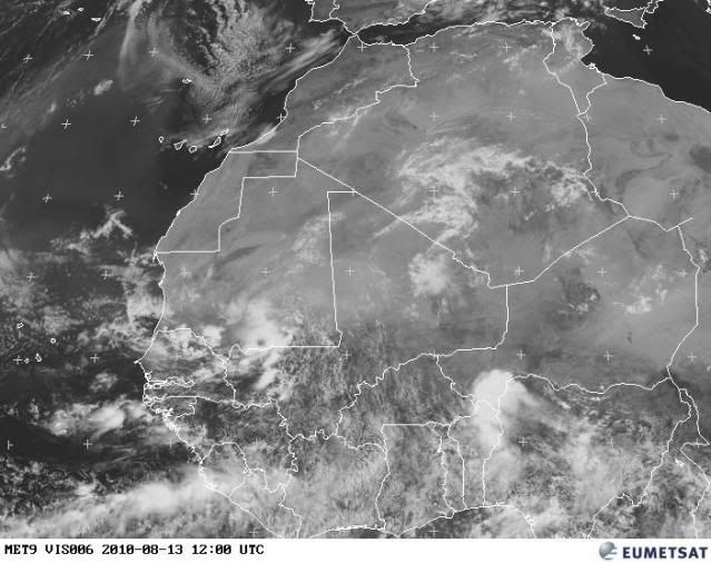
Here is the visible image of Central Africa where you can see the circulation around 10N.

0 likes
Visit the Caribbean-Central America Weather Thread where you can find at first post web cams,radars
and observations from Caribbean basin members Click Here
and observations from Caribbean basin members Click Here
-
cycloneye
- Admin
- Posts: 149585
- Age: 69
- Joined: Thu Oct 10, 2002 10:54 am
- Location: San Juan, Puerto Rico
Re: Strong wave in WestCentral Africa (Models develop it)
Interesting discussion by the folks who do test invests.
http://catalog.eol.ucar.edu/cgi-bin/pre ... ssion.html
Both the NCEP and ECMWF ensembles initialized at 00 UTC Aug 12th
predicted a vigorous wave moving off Africa at 6-7 days (Aug
18th-19th). Several members in both ensembles predicted a
closed low-level circulation, albeit with lower values of
low-level circulation and 250-800 hPa thickness anomaly than is
consistent with cyclogenesis.
10-day outlook
The same vigorous wave noted in yesterday's forecasts is
expected to move off Africa this coming Tuesday between 12 UTC
Aug 17th and 00 UTC Aug 18th (a little faster than had been
anticipated yesterday). NCEP ensemble members are tightly
clustered. There is almost unanimous agreement among
the NCEP members that a closed low-level circulation will
develop and sustain itself through to Day 10 (00 UTC Aug 23rd).
Thickness anomalies are favorable, suggesting the
likelihood of a warm-core system. 700-850 hPa circulation
values are marginal, suggesting that the low-level circulations
may not be vertically coherent. The system is predicted to gain
significant latitude as it moves downstream, typically
approaching 20N by the time it has reached 40-50W. Deep-layer
wind shear is not obviously favourable: 70% of the ensemble
members predict >10m/s wind shear in the vicinity of the
low-level circulation. The moisture of the
large-scale environment is also not obviously favourable, with
less than 50% of the NCEP members suggesting a >70% (>85%) RH at
700 (850) hPa.
0 likes
Visit the Caribbean-Central America Weather Thread where you can find at first post web cams,radars
and observations from Caribbean basin members Click Here
and observations from Caribbean basin members Click Here
-
ConvergenceZone
.gif)
- Category 5
- Posts: 5241
- Joined: Fri Jul 29, 2005 1:40 am
- Location: Northern California


Models suggest something similar in terms of location of where this one comes off as 93L...the ECM shows only slow development which I think is more likely then the GFS solution of it strengthening quickly and speeding off to the NW right away.
Still I do think its going to be pretty likely this one recurves but probably is a little early to be totally confident, still scope for the synoptics to change.
Still I do think its going to be pretty likely this one recurves but probably is a little early to be totally confident, still scope for the synoptics to change.
0 likes
Personal Forecast Disclaimer:
The posts in this forum are NOT official forecast and should not be used as such. They are just the opinion of the poster and may or may not be backed by sound meteorological data. They are NOT endorsed by any professional institution or storm2k.org. For official information, please refer to the NHC and NWS products
The posts in this forum are NOT official forecast and should not be used as such. They are just the opinion of the poster and may or may not be backed by sound meteorological data. They are NOT endorsed by any professional institution or storm2k.org. For official information, please refer to the NHC and NWS products
Who is online
Users browsing this forum: No registered users and 235 guests