
>>I saw his video. What I'm not sure about is how much of this low is left in 24 hrs. Will there be any low center to strengthen on Sunday as it's moving toward the coast?
Yeah, the $64k question. Seems like abundant energy and tap into moisture for now, but what's going to be left and for how long are important elements for possible re-genesis. It's certainly not been in a hurry to move since it reformed south of NWFL the other night. It doesn't look to be picking up speed any time soon either. Luckily it appears that it's something we can watch the evolution of on our doorsteps without having to worry about anything getting too strong.
ATL: EX-Tropical Depression FIVE - Discussion
Moderator: S2k Moderators
-
Dean4Storms
- S2K Supporter

- Posts: 6358
- Age: 63
- Joined: Sun Aug 31, 2003 1:01 pm
- Location: Miramar Bch. FL
When this broad low moved offshore SW FL it took it just a day to develop a closed low in less than favorable UL conditions. In this situation we will have at least a broad low at the surface with what looks like a very well defined MLC and more favorable UL conditions, add the 88 to 90 degree SST's and no shear and I believe the remnants of TD5 could deepen rather significantly, this needs to be watched closely with all the model support bringing it either close or offshore altogether and the NHC ought to be calling it an invest with TWO discussions about it, I know they would be doing it if it had crossed the Yucatan. This low is not dead and neither is the MLC with it.
We are getting the stiffest SW winds and winds period that we ever got with TD 5 as it passed to the south here in Destin, we've had gusts to around 20mph and good low level flow just above the surface heading Northward!!!
We are getting the stiffest SW winds and winds period that we ever got with TD 5 as it passed to the south here in Destin, we've had gusts to around 20mph and good low level flow just above the surface heading Northward!!!
0 likes
-
MiamiHurricanes10

- S2K Supporter
- Posts: 260
- Joined: Mon Jul 19, 2010 7:56 pm
- Location: Miami, Florida
Re: Models Develop Gulf System - EX-TD5 Thread
I-wall wrote:I dont see what all the fuss is about. TD 5 dissipated, remember guys?
Check this out from "The Free Dictionary":
"Dissipate: To vanish."
I don't think that it has vanished...do you?

0 likes
-
Ivanhater

- Storm2k Moderator

- Posts: 11221
- Age: 39
- Joined: Fri Jul 01, 2005 8:25 am
- Location: Pensacola
Re: Models Develop Gulf System - EX-TD5 Thread
18z Canadian never really gets that far inland..only goes to 48 hours but ends around the Florida/Georgia/Alabama line.
That would be interesting and would lead to more strengthening if it didn't get that far inland. Heavy rain noted

That would be interesting and would lead to more strengthening if it didn't get that far inland. Heavy rain noted
0 likes
Michael

Oh if it does get out into the water Dean I think redevelopment is not just possible but pretty probable but its a real tightrope type situation, every mile really is going to make the difference with this synoptic set-up I feel...
It looks amazing tonight, probably will barely need to get off the coast for the NHC to be tempted to upgrade it if it can hold its LLC.
It looks amazing tonight, probably will barely need to get off the coast for the NHC to be tempted to upgrade it if it can hold its LLC.
0 likes
Personal Forecast Disclaimer:
The posts in this forum are NOT official forecast and should not be used as such. They are just the opinion of the poster and may or may not be backed by sound meteorological data. They are NOT endorsed by any professional institution or storm2k.org. For official information, please refer to the NHC and NWS products
The posts in this forum are NOT official forecast and should not be used as such. They are just the opinion of the poster and may or may not be backed by sound meteorological data. They are NOT endorsed by any professional institution or storm2k.org. For official information, please refer to the NHC and NWS products
-
Dean4Storms
- S2K Supporter
- Posts: 6358
- Age: 63
- Joined: Sun Aug 31, 2003 1:01 pm
- Location: Miramar Bch. FL
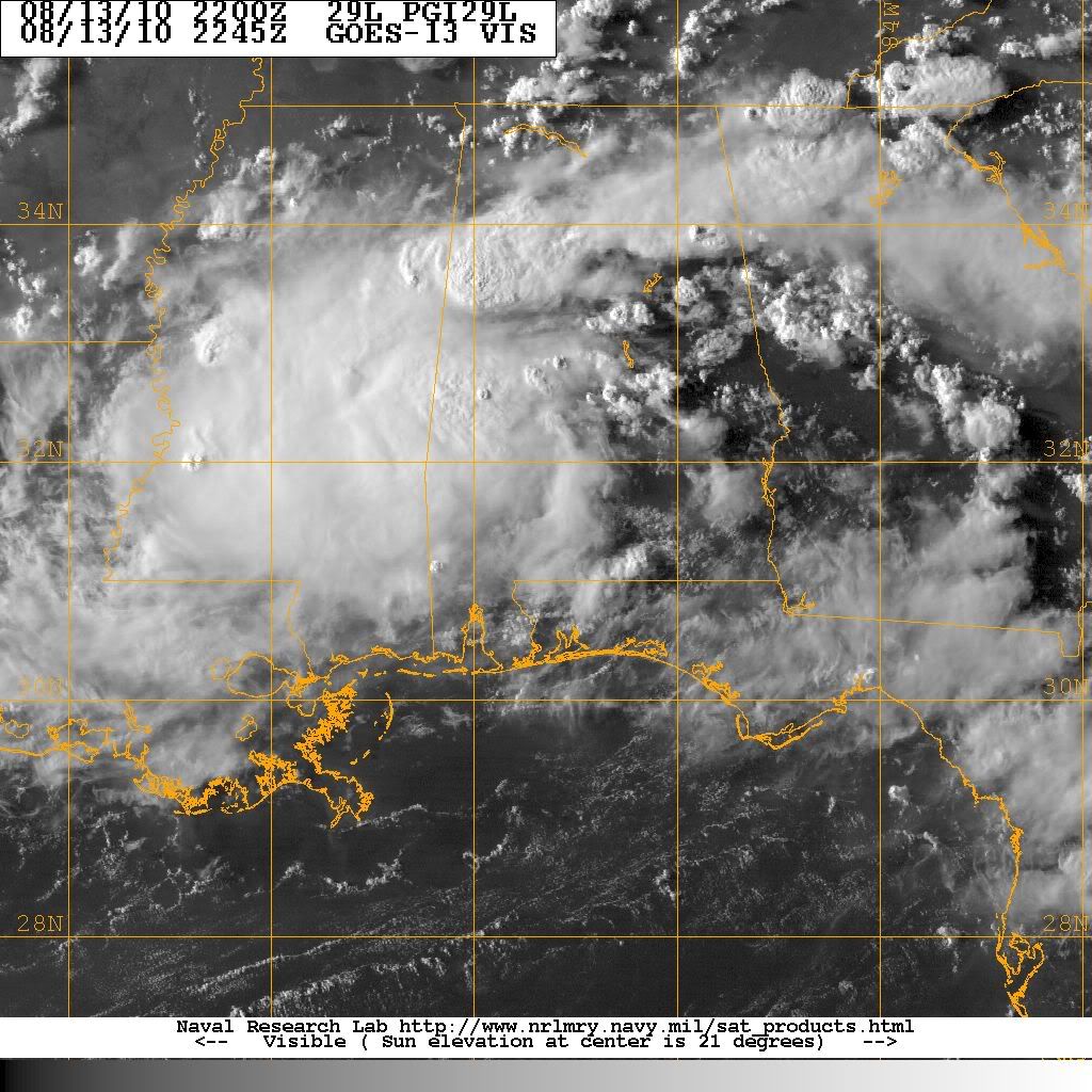
Note the Low level clouds beginning to swirl moreso into the LLC over southern Alabama just before the high cloud obscure the view!! I place the LLC NNE of Mobile by 100 miles or so.
http://www.rap.ucar.edu/weather/satelli ... duration=6
http://www.rap.ucar.edu/weather/satelli ... duration=6
0 likes
-
Ivanhater
- Storm2k Moderator
- Posts: 11221
- Age: 39
- Joined: Fri Jul 01, 2005 8:25 am
- Location: Pensacola
Re: Models Develop Gulf System - EX-TD5 Thread
Yeah, I would say flooding could be an issue

0 likes
Michael
I still can't over that IR image there, thats quite impressive look and the MLC probably is very strong at the moment. Really think if this one gets over water it'll get going.
0 likes
Personal Forecast Disclaimer:
The posts in this forum are NOT official forecast and should not be used as such. They are just the opinion of the poster and may or may not be backed by sound meteorological data. They are NOT endorsed by any professional institution or storm2k.org. For official information, please refer to the NHC and NWS products
The posts in this forum are NOT official forecast and should not be used as such. They are just the opinion of the poster and may or may not be backed by sound meteorological data. They are NOT endorsed by any professional institution or storm2k.org. For official information, please refer to the NHC and NWS products
-
wxman57

- Moderator-Pro Met

- Posts: 23175
- Age: 68
- Joined: Sat Jun 21, 2003 8:06 pm
- Location: Houston, TX (southwest)
Re:
Dean4Storms wrote:Note the Low level clouds beginning to swirl moreso into the LLC over southern Alabama just before the high cloud obscure the view!! I place the LLC NNE of Mobile by 100 miles or so.
http://www.rap.ucar.edu/weather/satelli ... duration=6
Dean,
Surface wind obs through that area of convection look to be from the W-WSW (maybe SSW-SW), indicating no LLC there. Meridian, MS, on the northwest side of the convection had a WSW wind at 10 kts recently (calm now). But the remnants appear to be in the only part of Alabama that's mostly free of good observations. Obs near Birmingham suggest there may be a weak low east of the convection maybe 30-40 miles west of Birmingham. But there are no obs to confirm any northerly or northwest winds. Obs do indicate a surface trof, at least. Will have to wait for it to move somewhere near an observing station.
Here's a 23Z plot to show what I mean:

0 likes
-
srainhoutx

- S2K Supporter
- Posts: 6919
- Age: 68
- Joined: Sun Jan 14, 2007 11:34 am
- Location: Haywood County, NC
- Contact:
Re: Models Develop Gulf System - EX-TD5 Thread
Latest...
0 likes
Carla/Alicia/Jerry(In The Eye)/Michelle/Charley/Ivan/Dennis/Katrina/Rita/Wilma/Ike/Harvey
Member: National Weather Association
Wx Infinity Forums
http://wxinfinity.com/index.php
Facebook.com/WeatherInfinity
Twitter @WeatherInfinity
Member: National Weather Association
Wx Infinity Forums
http://wxinfinity.com/index.php
Facebook.com/WeatherInfinity
Twitter @WeatherInfinity
Ouch 13 inches of rain according to the GFS, thats quite impressive really and would certainly lead to flooding issues.
0 likes
Personal Forecast Disclaimer:
The posts in this forum are NOT official forecast and should not be used as such. They are just the opinion of the poster and may or may not be backed by sound meteorological data. They are NOT endorsed by any professional institution or storm2k.org. For official information, please refer to the NHC and NWS products
The posts in this forum are NOT official forecast and should not be used as such. They are just the opinion of the poster and may or may not be backed by sound meteorological data. They are NOT endorsed by any professional institution or storm2k.org. For official information, please refer to the NHC and NWS products
-
Dean4Storms
- S2K Supporter
- Posts: 6358
- Age: 63
- Joined: Sun Aug 31, 2003 1:01 pm
- Location: Miramar Bch. FL
Re: Re:
wxman57 wrote:Dean4Storms wrote:Note the Low level clouds beginning to swirl moreso into the LLC over southern Alabama just before the high cloud obscure the view!! I place the LLC NNE of Mobile by 100 miles or so.
http://www.rap.ucar.edu/weather/satelli ... duration=6
Dean,
Surface wind obs through that area of convection look to be from the W-WSW (maybe SSW-SW), indicating no LLC there. Meridian, MS, on the northwest side of the convection had a WSW wind at 10 kts recently (calm now). But the remnants appear to be in the only part of Alabama that's mostly free of good observations. Obs near Birmingham suggest there may be a weak low east of the convection maybe 30-40 miles west of Birmingham. But there are no obs to confirm any northerly or northwest winds. Obs do indicate a surface trof, at least. Will have to wait for it to move somewhere near an observing station.
Here's a 23Z plot to show what I mean:
http://myweb.cableone.net/nolasue/5d.gif
I should have said LLC just above the surface at 850mb, the reason why I mentioned the LL Clouds. You are correct, surface obs indicate just a broad low there for now.
*Edit by Ivanhater to remove IMG tags
0 likes
-
lrak

- S2K Supporter
- Posts: 1770
- Age: 59
- Joined: Thu Jun 21, 2007 2:48 pm
- Location: Corpus Christi, TX
Re: Models Develop Gulf System - EX-TD5 Thread
Demopolis looks like the center if you watch this long range loop real fast.
http://radar.weather.gov/radar.php?rid= ... 1&loop=yes
Tuscaloosa Regional Airport
Lat: 33.23 Lon: -87.62 Elev: 186
Last Update on Aug 13, 5:53 pm CDT
A Few Clouds
91 °F
(33 °C) Humidity: 56 %
Wind Speed: W 3 MPH
Barometer: 29.78" (1008.3 mb)
Dewpoint: 73 °F (23 °C)
Heat Index: 100 °F (38 °C)
Visibility: 10.00 mi
0 likes
AKA karl
Also
Personal Forecast Disclaimer:
My posts on this forum are NOT official forecast and should not be used as such. My posts are my basic observations and are definitely not backed by any "well some" meteorological knowledge. For official information, please refer to the NHC and NWS products.
Also
Personal Forecast Disclaimer:
My posts on this forum are NOT official forecast and should not be used as such. My posts are my basic observations and are definitely not backed by any "well some" meteorological knowledge. For official information, please refer to the NHC and NWS products.

Re: Models Develop Gulf System - EX-TD5 Thread
0 likes
-
allicat1214
- Tropical Low

- Posts: 29
- Joined: Tue Sep 20, 2005 3:48 pm
- Location: NOLA metro area
Ivan and Dean...
Are your local mets discussing this tonight? Are your folks watching for this? TV mets in NOLA have all discussed the various loopedy loop scenarios on this evening's news. But no mention at all from TWC.
Just wondering because it looks like a major problem brewing for Mobile-Panama City as far as rain....and then all across the Gulf Coast if it gets over water long enuf to fire up and then move west.....
I got about 3.5 inches of rain today in about 2 hours.....flooding ditches and began to cover edges of street very quickly because the ground is saturated!!
I'm hoping everyone is prepared!!
0 likes
-
Ivanhater
- Storm2k Moderator
- Posts: 11221
- Age: 39
- Joined: Fri Jul 01, 2005 8:25 am
- Location: Pensacola
Re: Models Develop Gulf System - EX-TD5 Thread
They are talking about it. Flooding looks to be the main issue right now, but tropical storm conditions are very possible if it gets over water. I think it's almost impossible right now to know if it does or not but it will be interesting to see this evolve with the models strengthening the low as it moves south toward the coast.
0 likes
Michael
-
Dean4Storms
- S2K Supporter
- Posts: 6358
- Age: 63
- Joined: Sun Aug 31, 2003 1:01 pm
- Location: Miramar Bch. FL
Re:
allicat1214 wrote:Ivan and Dean...
Are your local mets discussing this tonight? Are your folks watching for this? TV mets in NOLA have all discussed the various loopedy loop scenarios on this evening's news. But no mention at all from TWC.
Just wondering because it looks like a major problem brewing for Mobile-Panama City as far as rain....and then all across the Gulf Coast if it gets over water long enuf to fire up and then move west.....
I got about 3.5 inches of rain today in about 2 hours.....flooding ditches and began to cover edges of street very quickly because the ground is saturated!!
I'm hoping everyone is prepared!!
I've got Direct TV and I'm too far out of range for the local stations. I get everything local from the NWS sites in Mobile and Tally, FL and elsewhere off the internet.
0 likes
Re: Models Develop Gulf System - EX-TD5 Thread
Raininfyr wrote::uarrow: That picture is amazing, TD 5 looks better over land. NWS in New Orleans was talking about a loop de loop. Pretty cool stuff happening on our back porch where we can observe.
Yeah it looks pretty impressive still at the moment, and yeah it does look alot better inland, the models look like they made a good call in increasing the Vorticity inland like they called for.
We now need to watch for the southerly motion to begin, this will be key in knowing how much of a shot it stands to get into the Gulf in the first place.
0 likes
Personal Forecast Disclaimer:
The posts in this forum are NOT official forecast and should not be used as such. They are just the opinion of the poster and may or may not be backed by sound meteorological data. They are NOT endorsed by any professional institution or storm2k.org. For official information, please refer to the NHC and NWS products
The posts in this forum are NOT official forecast and should not be used as such. They are just the opinion of the poster and may or may not be backed by sound meteorological data. They are NOT endorsed by any professional institution or storm2k.org. For official information, please refer to the NHC and NWS products
-
CYCLONE MIKE
- Category 5

- Posts: 2183
- Joined: Tue Aug 31, 2004 6:04 pm
- Location: Gonzales, LA
Re: Models Develop Gulf System - EX-TD5 Thread
Just catching up on the latest developments on TD5 pt2. When is this forecast to stall its northward movement and then start its trek back towards the gulf? I do have to say, the agreement between all the models on this scenario happening are pretty surprising. This is not looking good for the low lying areas of the gulf coast cities.
Btw our nws office already has a 60% chance of storms for us on Tuesday!!! They are usually ultra conservative waiting as long as possible to mke adjustments ie. when everyone thought TD5 would be upgraded to Danielle and TS warnings were issued for southeast LA, New Orleans, Houma, Slidell and other cities were forecast to have a couple of inches of rain w/ ts conditions while in my town about 60 miles from N.O. we only had a 40% chance.
Btw our nws office already has a 60% chance of storms for us on Tuesday!!! They are usually ultra conservative waiting as long as possible to mke adjustments ie. when everyone thought TD5 would be upgraded to Danielle and TS warnings were issued for southeast LA, New Orleans, Houma, Slidell and other cities were forecast to have a couple of inches of rain w/ ts conditions while in my town about 60 miles from N.O. we only had a 40% chance.
0 likes
-
Dean4Storms
- S2K Supporter
- Posts: 6358
- Age: 63
- Joined: Sun Aug 31, 2003 1:01 pm
- Location: Miramar Bch. FL
Who is online
Users browsing this forum: No registered users and 30 guests