ATL: EX-Tropical Depression FIVE - Discussion
Moderator: S2k Moderators

Yeah indeed Macrocane looks like this one is a great contender for redevelopment IMO...
0 likes
Personal Forecast Disclaimer:
The posts in this forum are NOT official forecast and should not be used as such. They are just the opinion of the poster and may or may not be backed by sound meteorological data. They are NOT endorsed by any professional institution or storm2k.org. For official information, please refer to the NHC and NWS products
The posts in this forum are NOT official forecast and should not be used as such. They are just the opinion of the poster and may or may not be backed by sound meteorological data. They are NOT endorsed by any professional institution or storm2k.org. For official information, please refer to the NHC and NWS products


-
southerngale

- Retired Staff

- Posts: 27418
- Joined: Thu Oct 10, 2002 1:27 am
- Location: Southeast Texas (Beaumont area)
Re: Models Develop Gulf System - EX-TD5 Thread
Wx_Warrior wrote:12z is not upper texas coast...FWIW
He's probably referring to this post, but it looks more like SW LA.
0 likes
Please support Storm2k by making a donation today. It is greatly appreciated! Click here: 
 my Cowboys my Rockets my Astros
my Cowboys my Rockets my Astros-
MiamiHurricanes10

- S2K Supporter

- Posts: 260
- Joined: Mon Jul 19, 2010 7:56 pm
- Location: Miami, Florida
Re:
KWT wrote:Looks like Isabel...well thats a new one, a weak low being compared with a major
hurricane
Good to see this one in the active forum again where it belongs!
Anyway something does look like its getting going down there...
(Large image so I'll just link it)
http://upload.wikimedia.org/wikipedia/commons/2/2a/Hurricane_Isabel_14_sept_2003_1445Z.jpg
0 likes
-
curtadams
- S2K Supporter
- Posts: 1122
- Joined: Sun Aug 28, 2005 7:57 pm
- Location: Orange, California
- Contact:
The only models that foresee a TS are the very bullish CMC and HWRF models. Everything else sees something, but mostly the kinds of weak storms the NHC normally dithers about even giving a number to (broad lows, barely offshore, weak winds). I'd agree the chances of a TC are a little higher than the NHC's estimate but I think odds are very against a TS.
0 likes
-
MiamiHurricanes10
- S2K Supporter
- Posts: 260
- Joined: Mon Jul 19, 2010 7:56 pm
- Location: Miami, Florida
Re: EX-Tropical Depression FIVE - Discussion
Bending features developing on the western side of the COC with the daytime heating. This thing is going to pop when it hits the GOM.

Last edited by MiamiHurricanes10 on Sun Aug 15, 2010 2:16 pm, edited 1 time in total.
0 likes
Really Curtadams, I'd say the chances are pretty decent, sure the models show generally a weak system but really there isn't much difference between a 30kts depression like the GFDL has and a 40kts system the HWRF has, even just stronger convection can make the difference really!
0 likes
Personal Forecast Disclaimer:
The posts in this forum are NOT official forecast and should not be used as such. They are just the opinion of the poster and may or may not be backed by sound meteorological data. They are NOT endorsed by any professional institution or storm2k.org. For official information, please refer to the NHC and NWS products
The posts in this forum are NOT official forecast and should not be used as such. They are just the opinion of the poster and may or may not be backed by sound meteorological data. They are NOT endorsed by any professional institution or storm2k.org. For official information, please refer to the NHC and NWS products
-
wxman57

- Moderator-Pro Met

- Posts: 23175
- Age: 68
- Joined: Sat Jun 21, 2003 8:06 pm
- Location: Houston, TX (southwest)
Re: Models Develop Gulf System - EX-TD5 Thread
southerngale wrote:Wx_Warrior wrote:12z is not upper texas coast...FWIW
He's probably referring to this post, but it looks more like SW LA.
I'm plotting surface pressures down to 1/4 millibar. GFS has it inland near Grand Isle, LA and passing north of Lafayette and well north of Lake Charles. At 84 hrs, it's at 31.4N/94.9W, just west of Lufkin. I guess we could call it east-central TX. Maybe close enough to us to give us some rain. Of course, this assumes a perfect GFS forecast, and the GFS has never been wrong with a tropical system...
0 likes
-
MiamiHurricanes10
- S2K Supporter
- Posts: 260
- Joined: Mon Jul 19, 2010 7:56 pm
- Location: Miami, Florida
Upper level conditions will be prime for intensification. Dry air will be minimal and SSTs will be plenty warm. All it needs is a day or two to become a tropical storm. Plus, it could be making landfall over the Louisiana marsh, that should help it, sorta' like the everglades did to Katrina. (No I'm not comparing this to Katrina, it's just an example of how marsh land can help a tropical cyclone).
Last edited by MiamiHurricanes10 on Sun Aug 15, 2010 2:20 pm, edited 1 time in total.
0 likes
-
Wx_Warrior
- Category 5

- Posts: 2718
- Joined: Thu Aug 03, 2006 3:58 pm
- Location: Beaumont, TX
Re: ATL: EX-Tropical Depression FIVE - Discussion
I think he ment that was when it was in SETX, not landfall SETX. Anyhow, it's super dry here, but don't need any flood event.
0 likes
-
Dean4Storms
- S2K Supporter
- Posts: 6358
- Age: 63
- Joined: Sun Aug 31, 2003 1:01 pm
- Location: Miramar Bch. FL
-
Dean4Storms
- S2K Supporter
- Posts: 6358
- Age: 63
- Joined: Sun Aug 31, 2003 1:01 pm
- Location: Miramar Bch. FL
Re:
curtadams wrote:The only models that foresee a TS are the very bullish CMC and HWRF models. Everything else sees something, but mostly the kinds of weak storms the NHC normally dithers about even giving a number to (broad lows, barely offshore, weak winds). I'd agree the chances of a TC are a little higher than the NHC's estimate but I think odds are very against a TS.
You only have to have winds of 40mph to have a TS and with SST's near 90 and very favorable UL conditions along with a good structure already spinning and in place this could easily reach 40mph sustained TS status in 2 days IMO!!
Actually 2 1/2 to 3 days over water if you go by the HWRF landfall prediction in LA!!
Last edited by Dean4Storms on Sun Aug 15, 2010 2:23 pm, edited 1 time in total.
0 likes
Re:
MiamiHurricanes10 wrote:Upper level conditions will be prime for intensification. Dry air will be minimal and SSTs will be plenty warm. All it needs is a day or two to become a tropical storm.
Yeah that would easily be enough time for a 35-45kts system to ramp up, esp one that has a pretty decent MLC and a LLC reflection still present.
Also I agree, it looks pretty good on the radar, perhaps the MLC is a little south of where the models were expecting right now.
0 likes
Personal Forecast Disclaimer:
The posts in this forum are NOT official forecast and should not be used as such. They are just the opinion of the poster and may or may not be backed by sound meteorological data. They are NOT endorsed by any professional institution or storm2k.org. For official information, please refer to the NHC and NWS products
The posts in this forum are NOT official forecast and should not be used as such. They are just the opinion of the poster and may or may not be backed by sound meteorological data. They are NOT endorsed by any professional institution or storm2k.org. For official information, please refer to the NHC and NWS products

Re: Re:
Dean4Storms wrote:
You only have to have winds of 40mph to have a TS and with SST's near 90 and very favorable UL conditions along with a good structure already spinning and in place this could easily reach 40mph sustained TS status in 2 days IMO!!
Actually 2 1/2 to 3 days over water if you go by the HWRF landfall prediction in LA!!
As Humberto proved you actually only really need 24hrs for a hurricane in the right set-up yet alone a minimal TS!
0 likes
Personal Forecast Disclaimer:
The posts in this forum are NOT official forecast and should not be used as such. They are just the opinion of the poster and may or may not be backed by sound meteorological data. They are NOT endorsed by any professional institution or storm2k.org. For official information, please refer to the NHC and NWS products
The posts in this forum are NOT official forecast and should not be used as such. They are just the opinion of the poster and may or may not be backed by sound meteorological data. They are NOT endorsed by any professional institution or storm2k.org. For official information, please refer to the NHC and NWS products
-
srainhoutx

- S2K Supporter
- Posts: 6919
- Age: 68
- Joined: Sun Jan 14, 2007 11:34 am
- Location: Haywood County, NC
- Contact:
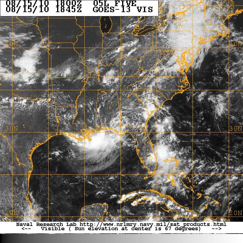
Re: ATL: EX-Tropical Depression FIVE - Discussion
Big view...
0 likes
Carla/Alicia/Jerry(In The Eye)/Michelle/Charley/Ivan/Dennis/Katrina/Rita/Wilma/Ike/Harvey
Member: National Weather Association
Wx Infinity Forums
http://wxinfinity.com/index.php
Facebook.com/WeatherInfinity
Twitter @WeatherInfinity
Member: National Weather Association
Wx Infinity Forums
http://wxinfinity.com/index.php
Facebook.com/WeatherInfinity
Twitter @WeatherInfinity
It sort of looks like a half system there srainhoutx!
With the system being so close to the system we will be able to get a good idea of what this system is doing in terms of even the lower levels.
Also good to have recon flying into this again soon!
With the system being so close to the system we will be able to get a good idea of what this system is doing in terms of even the lower levels.
Also good to have recon flying into this again soon!
0 likes
Personal Forecast Disclaimer:
The posts in this forum are NOT official forecast and should not be used as such. They are just the opinion of the poster and may or may not be backed by sound meteorological data. They are NOT endorsed by any professional institution or storm2k.org. For official information, please refer to the NHC and NWS products
The posts in this forum are NOT official forecast and should not be used as such. They are just the opinion of the poster and may or may not be backed by sound meteorological data. They are NOT endorsed by any professional institution or storm2k.org. For official information, please refer to the NHC and NWS products
-
Dean4Storms
- S2K Supporter
- Posts: 6358
- Age: 63
- Joined: Sun Aug 31, 2003 1:01 pm
- Location: Miramar Bch. FL
-
cycloneye

- Admin

- Posts: 149596
- Age: 69
- Joined: Thu Oct 10, 2002 10:54 am
- Location: San Juan, Puerto Rico
Re:
Dean4Storms wrote:90 pages!! I think this maybe a Storm2K record for a Tropical Depression!!!
Nope. Remember,the thread was merged with the one at Talking tropics.
0 likes
Visit the Caribbean-Central America Weather Thread where you can find at first post web cams,radars
and observations from Caribbean basin members Click Here
and observations from Caribbean basin members Click Here
-
ColinDelia

- S2K Supporter
- Posts: 918
- Joined: Mon Aug 29, 2005 5:52 am
- Location: The Beach, FL
Who is online
Users browsing this forum: No registered users and 39 guests