
Its just a big convective blow-up...probably a MCS system that has developed due to the increasingly favourable conditions near ex-TD5...
Ya know the type we all scream over with waves in Africa, only to see it totally poof 6-12hrs later...
ATL: EX-Tropical Depression FIVE - Discussion
Moderator: S2k Moderators
0 likes
Personal Forecast Disclaimer:
The posts in this forum are NOT official forecast and should not be used as such. They are just the opinion of the poster and may or may not be backed by sound meteorological data. They are NOT endorsed by any professional institution or storm2k.org. For official information, please refer to the NHC and NWS products
The posts in this forum are NOT official forecast and should not be used as such. They are just the opinion of the poster and may or may not be backed by sound meteorological data. They are NOT endorsed by any professional institution or storm2k.org. For official information, please refer to the NHC and NWS products
-
hurricaneCW
- Category 5

- Posts: 1799
- Joined: Wed Mar 03, 2010 6:20 am
- Location: Toms River, NJ
Re: ATL: EX-Tropical Depression FIVE - Discussion
I just viewed the gulf of mexico visible before the sunset and it's spectacular. The southern outflow looks like it belongs to a large, major hurricane. It indicates the conditions are very favorable for development over water.
0 likes
-
brunota2003

- S2K Supporter

- Posts: 9476
- Age: 35
- Joined: Sat Jul 30, 2005 9:56 pm
- Location: Stanton, KY...formerly Havelock, NC
- Contact:
All those heavy storms have shot out outflow boundaries and are heading due south, so expect them to fall apart. Further to the east, the only signs of a circulation on the radar, is just moving offshore of Florida (pretty much right on the coast). It looks like the circulation is small, judging by radar and storms to it's NE heading south.
Regional Radar Loop:
http://radar.weather.gov/Conus/southmissvly_loop.php
Regional Radar Loop:
http://radar.weather.gov/Conus/southmissvly_loop.php
0 likes
Re: ATL: EX-Tropical Depression FIVE - Discussion
So how much storm can the oil rigs in the Gulf handle, and have guys been evacuated or is that a potential problem for them?
0 likes
Yeah Brutona those MCS systems whilst impressive have no support in terms of rotation and so they tend to poof pretty rapidly once the forcing starts to decrease, and in this case it will decrease as it diverts eastwards as the system moves into the water.
0 likes
Personal Forecast Disclaimer:
The posts in this forum are NOT official forecast and should not be used as such. They are just the opinion of the poster and may or may not be backed by sound meteorological data. They are NOT endorsed by any professional institution or storm2k.org. For official information, please refer to the NHC and NWS products
The posts in this forum are NOT official forecast and should not be used as such. They are just the opinion of the poster and may or may not be backed by sound meteorological data. They are NOT endorsed by any professional institution or storm2k.org. For official information, please refer to the NHC and NWS products
-
brunota2003
- S2K Supporter
- Posts: 9476
- Age: 35
- Joined: Sat Jul 30, 2005 9:56 pm
- Location: Stanton, KY...formerly Havelock, NC
- Contact:
Re:
Aric Dunn wrote:latest analysis I have the area of low pressure beginning to take shape along the coast near panama city..
Yep...that is actually right where I was talking about above on the regional radar.
0 likes
I agree Aric though its pretty weak feature still, but that will strengthen once it gets over water for sure.
0 likes
Personal Forecast Disclaimer:
The posts in this forum are NOT official forecast and should not be used as such. They are just the opinion of the poster and may or may not be backed by sound meteorological data. They are NOT endorsed by any professional institution or storm2k.org. For official information, please refer to the NHC and NWS products
The posts in this forum are NOT official forecast and should not be used as such. They are just the opinion of the poster and may or may not be backed by sound meteorological data. They are NOT endorsed by any professional institution or storm2k.org. For official information, please refer to the NHC and NWS products
-
srainhoutx

- S2K Supporter
- Posts: 6919
- Age: 68
- Joined: Sun Jan 14, 2007 11:34 am
- Location: Haywood County, NC
- Contact:
Re:
KWT wrote:Yeah Brutona those MCS systems whilst impressive have no support in terms of rotation and so they tend to poof pretty rapidly once the forcing starts to decrease, and in this case it will decrease as it diverts eastwards as the system moves into the water.
Unless this becomes a MCV system. Remember how the HPC mentioned convective feedback early on? How this eventually develops remains to be seen IMO.
0 likes
Carla/Alicia/Jerry(In The Eye)/Michelle/Charley/Ivan/Dennis/Katrina/Rita/Wilma/Ike/Harvey
Member: National Weather Association
Wx Infinity Forums
http://wxinfinity.com/index.php
Facebook.com/WeatherInfinity
Twitter @WeatherInfinity
Member: National Weather Association
Wx Infinity Forums
http://wxinfinity.com/index.php
Facebook.com/WeatherInfinity
Twitter @WeatherInfinity
-
Aric Dunn
- Category 5
- Posts: 21238
- Age: 43
- Joined: Sun Sep 19, 2004 9:58 pm
- Location: Ready for the Chase.
- Contact:
Re:
KWT wrote:I agree Aric though its pretty weak feature still, but that will strengthen once it gets over water for sure.
its more a reformation than a movement since there was not really a defined center in the first place convection beginning to fire now offshore is the area to watch ..
0 likes
-
Dean4Storms
- S2K Supporter
- Posts: 6358
- Age: 63
- Joined: Sun Aug 31, 2003 1:01 pm
- Location: Miramar Bch. FL
-
brunota2003
- S2K Supporter
- Posts: 9476
- Age: 35
- Joined: Sat Jul 30, 2005 9:56 pm
- Location: Stanton, KY...formerly Havelock, NC
- Contact:
Re:
KWT wrote:Yeah Brutona those MCS systems whilst impressive have no support in terms of rotation and so they tend to poof pretty rapidly once the forcing starts to decrease, and in this case it will decrease as it diverts eastwards as the system moves into the water.
Yep...like the ones off Africa. They spit out some nice outflow boundaries, so I expect (especially with the sun going down) they'll become way less impressive over the next couple hours.
0 likes

Re: ATL: EX-Tropical Depression FIVE - Discussion
A lot of people are thinking the Upper level conditions are going to so ripe but those ideal conditions seem to farther to the west and may not be there when XTD5 gets there.
Mid level shear not real bad.
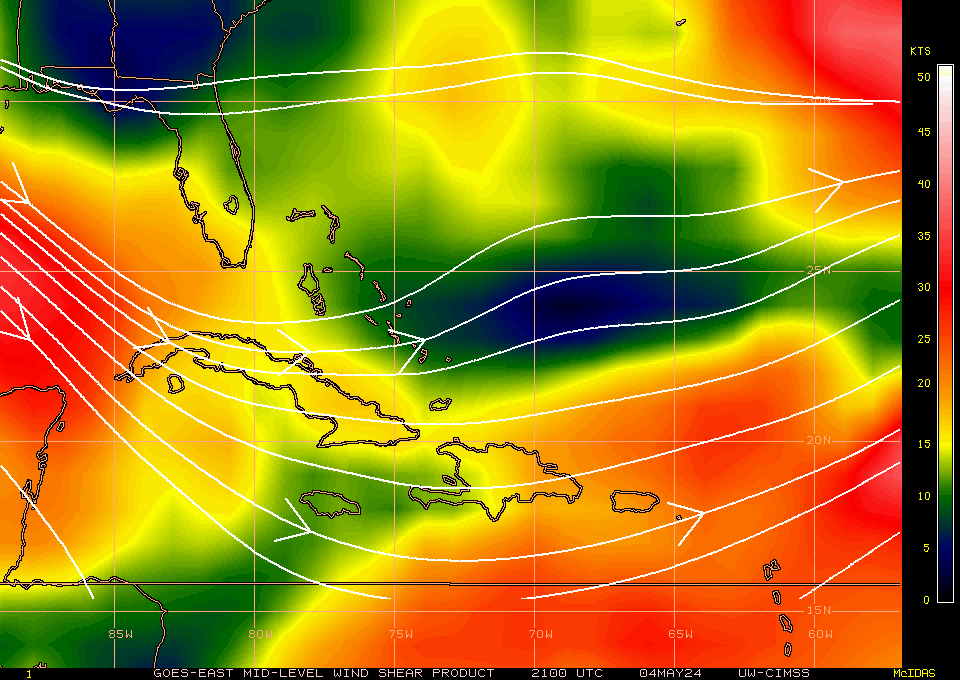
Upper shear not favorable south or east of system.
Mid level shear not real bad.
Upper shear not favorable south or east of system.
0 likes
The following post is NOT an official forecast and should not be used as such. It is just the opinion of the poster and may or may not be backed by sound meteorological data. It is NOT endorsed by any professional institution including storm2k.org For Official Information please refer to the NHC and NWS products.
Re: Re:
srainhoutx wrote:
Unless this becomes a MCV system. Remember how the HPC mentioned convective feedback early on? How this eventually develops remains to be seen IMO.
Oh yeah of course but you'd be able to see some signs of that happening on the radar, there is not even a slight hint of anything in that convective blob and its going to probably weaken pretty soon anyway and head inland before it gets even a shot.
0 likes
Personal Forecast Disclaimer:
The posts in this forum are NOT official forecast and should not be used as such. They are just the opinion of the poster and may or may not be backed by sound meteorological data. They are NOT endorsed by any professional institution or storm2k.org. For official information, please refer to the NHC and NWS products
The posts in this forum are NOT official forecast and should not be used as such. They are just the opinion of the poster and may or may not be backed by sound meteorological data. They are NOT endorsed by any professional institution or storm2k.org. For official information, please refer to the NHC and NWS products
-
Dean4Storms
- S2K Supporter
- Posts: 6358
- Age: 63
- Joined: Sun Aug 31, 2003 1:01 pm
- Location: Miramar Bch. FL
This Panama City buoy report shows me that a closed low has passed by!!! Check the wind shifts and pressure falls.
http://www.ndbc.noaa.gov/station_page.php?station=pacf1
I should add that the winds are very weak, but it definitely shows a low passing through.
http://www.ndbc.noaa.gov/station_page.php?station=pacf1
I should add that the winds are very weak, but it definitely shows a low passing through.
0 likes
-
breaking wind
- Tropical Low

- Posts: 30
- Joined: Sun Aug 15, 2010 7:53 pm
- Location: Lakeland FL
Re: ATL: EX-Tropical Depression FIVE - Discussion
With no major convection near the LLC and most of the heavy precip moving off rapidly to the west, I can't see exTD5 regaining much strength in the next 48 even if it peeks its head into the gulf tomorrow although you have to be impressed with the way it has maintained over land the past few days. I don't see enough time over the water for it to become Bonnie, I mean Colin, aw heck, we need some named storms don't we so maybe it will reach minimal TS status which in 2010 means a 30+ mph gust. I'm just frustrated with these little GOM swirls, I want a Cape Verde monster.... that stays out to sea of course.
0 likes
-
MiamiHurricanes10

- S2K Supporter
- Posts: 260
- Joined: Mon Jul 19, 2010 7:56 pm
- Location: Miami, Florida
Re:
Dean4Storms wrote:This Panama City buoy report shows me that a closed low has passed by!!! Check the wind shifts and pressure falls.
http://www.ndbc.noaa.gov/station_page.php?station=pacf1
I should add that the winds are very weak, but it definitely shows a low passing through.
Very impressive! Something going on there.
0 likes
-
MiamiHurricanes10
- S2K Supporter
- Posts: 260
- Joined: Mon Jul 19, 2010 7:56 pm
- Location: Miami, Florida
Re: ATL: EX-Tropical Depression FIVE - Discussion
Upper level conditions are very favorable with an enormous upper level high parked atop ex-05L's low level circulation.
0 likes
-
Stormcenter
- S2K Supporter
- Posts: 6689
- Joined: Wed Sep 03, 2003 11:27 am
- Location: Houston, TX
Maybe the beginning of something starting up around the center.
http://www.rap.ucar.edu/weather/satelli ... uration=12
http://www.rap.ucar.edu/weather/satelli ... uration=12
0 likes
Who is online
Users browsing this forum: No registered users and 58 guests