ATL: EX-Tropical Depression FIVE - Discussion

Moderator: S2k Moderators

Message
Author
User avatar
cycloneye
Admin
Admin
Posts: 145303
Age: 68
Joined: Thu Oct 10, 2002 10:54 am
Location: San Juan, Puerto Rico

Re: ATL: EX-Tropical Depression FIVE - Discussion

#1981 Postby cycloneye » Mon Aug 16, 2010 6:36 am

60% Code Red

TROPICAL WEATHER OUTLOOK
NWS TPC/NATIONAL HURRICANE CENTER MIAMI FL
800 AM EDT MON AUG 16 2010

FOR THE NORTH ATLANTIC...CARIBBEAN SEA AND THE GULF OF MEXICO...

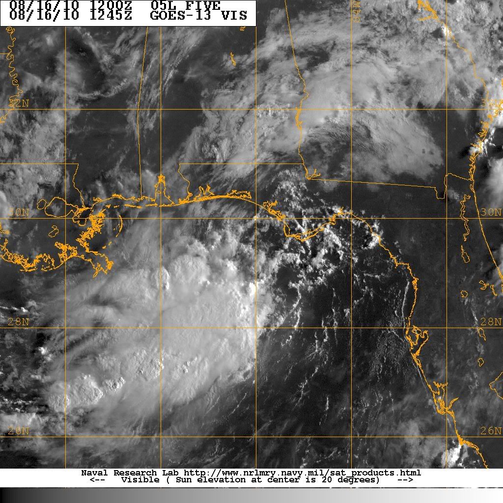
AN AREA OF LOW PRESSURE...THE REMNANT OF TROPICAL DEPRESSION
FIVE...IS LOCATED OVER THE NORTHEASTERN GULF OF MEXICO ABOUT 60
MILES SOUTHWEST OF PANAMA CITY FLORIDA. ENVIRONMENTAL CONDITIONS
ARE FORECAST TO BE CONDUCIVE FOR SOME DEVELOPMENT OF THIS SYSTEM AS
IT MOVES GENERALLY WESTWARD AND THEN WEST-NORTHWESTWARD OVER THE
NORTHERN GULF OF MEXICO DURING THE NEXT DAY OR SO. THERE IS A HIGH
CHANCE...60 PERCENT...OF THIS SYSTEM BECOMING A TROPICAL CYCLONE
AGAIN DURING THE NEXT 48 HOURS. REGARDLESS OF DEVELOPMENT...
LOCALLY HEAVY RAINFALL AND GUSTY WINDS ARE POSSIBLE ALONG PORTIONS
OF THE NORTH CENTRAL GULF OF MEXICO COAST THROUGH TUESDAY. SEE
STATEMENTS FROM LOCAL NATIONAL WEATHER SERVICE FORECAST OFFICES FOR
ADDITIONAL INFORMATION.

ELSEWHERE...TROPICAL CYCLONE FORMATION IS NOT EXPECTED DURING THE
NEXT 48 HOURS.

$$
FORECASTER KIMBERLAIN/PASCH

Image
0 likes   
Visit the Caribbean-Central America Weather Thread where you can find at first post web cams,radars
and observations from Caribbean basin members Click Here

Aric Dunn
Category 5
Category 5
Posts: 21238
Age: 42
Joined: Sun Sep 19, 2004 9:58 pm
Location: Ready for the Chase.
Contact:

Re:

#1982 Postby Aric Dunn » Mon Aug 16, 2010 6:54 am

ColinDelia wrote:Not much in the way of divergence aloft currently.


love the equation you have by the way :P ...... well the cimss map does not seem to showing much at the moment but there should be plenty of upper support to see this become a TD
0 likes   
Note: If I make a post that is brief. Please refer back to previous posts for the analysis or reasoning. I do not re-write/qoute what my initial post said each time.
If there is nothing before... then just ask :)

Space & Atmospheric Physicist, Embry-Riddle Aeronautical University,
I believe the sky is falling...

User avatar
cycloneye
Admin
Admin
Posts: 145303
Age: 68
Joined: Thu Oct 10, 2002 10:54 am
Location: San Juan, Puerto Rico

Re: ATL: EX-Tropical Depression FIVE - Discussion

#1983 Postby cycloneye » Mon Aug 16, 2010 7:37 am

12z Best Track

AL, 05, 2010081612, , BEST, 0, 294N, 861W, 20, 1009, LO

ftp://ftp.tpc.ncep.noaa.gov/atcf/tcweb/ ... 010.invest
0 likes   
Visit the Caribbean-Central America Weather Thread where you can find at first post web cams,radars
and observations from Caribbean basin members Click Here

Aric Dunn
Category 5
Category 5
Posts: 21238
Age: 42
Joined: Sun Sep 19, 2004 9:58 pm
Location: Ready for the Chase.
Contact:

#1984 Postby Aric Dunn » Mon Aug 16, 2010 7:43 am

Still no tight LLC ... broad is still the name of the game..
0 likes   
Note: If I make a post that is brief. Please refer back to previous posts for the analysis or reasoning. I do not re-write/qoute what my initial post said each time.
If there is nothing before... then just ask :)

Space & Atmospheric Physicist, Embry-Riddle Aeronautical University,
I believe the sky is falling...

User avatar
srainhoutx
S2K Supporter
S2K Supporter
Posts: 6919
Age: 67
Joined: Sun Jan 14, 2007 11:34 am
Location: Haywood County, NC
Contact:

Re: ATL: EX-Tropical Depression FIVE - Discussion

#1985 Postby srainhoutx » Mon Aug 16, 2010 7:44 am

Also the Best track is a bit further S and W.
0 likes   
Carla/Alicia/Jerry(In The Eye)/Michelle/Charley/Ivan/Dennis/Katrina/Rita/Wilma/Ike/Harvey

Member: National Weather Association
Wx Infinity Forums
http://wxinfinity.com/index.php

Facebook.com/WeatherInfinity
Twitter @WeatherInfinity

Aric Dunn
Category 5
Category 5
Posts: 21238
Age: 42
Joined: Sun Sep 19, 2004 9:58 pm
Location: Ready for the Chase.
Contact:

Re: ATL: EX-Tropical Depression FIVE - Discussion

#1986 Postby Aric Dunn » Mon Aug 16, 2010 7:47 am

srainhoutx wrote:Also the Best track is a bit further S and W.


my position last night 3am ...

Aric Dunn wrote:Pressures are starting to fall now ( about 1 MB in the last hour) and convection is becoming better organized. aprox center of developing LLC is 29.3N 86.2W.. accept a system nearing TD status but 11am ... if all goes well ...


its been nearly stationary for the last 6 hours..

cycloneye wrote:12z Best Track

AL, 05, 2010081612, , BEST, 0, 294N, 861W, 20, 1009, LO

ftp://ftp.tpc.ncep.noaa.gov/atcf/tcweb/ ... 010.invest
0 likes   
Note: If I make a post that is brief. Please refer back to previous posts for the analysis or reasoning. I do not re-write/qoute what my initial post said each time.
If there is nothing before... then just ask :)

Space & Atmospheric Physicist, Embry-Riddle Aeronautical University,
I believe the sky is falling...

Aric Dunn
Category 5
Category 5
Posts: 21238
Age: 42
Joined: Sun Sep 19, 2004 9:58 pm
Location: Ready for the Chase.
Contact:

#1987 Postby Aric Dunn » Mon Aug 16, 2010 8:17 am

well It seems the position of the upper high is just not in the right spot and is imparting too much shear... could still make it to TD but TS is looking less likely..
0 likes   
Note: If I make a post that is brief. Please refer back to previous posts for the analysis or reasoning. I do not re-write/qoute what my initial post said each time.
If there is nothing before... then just ask :)

Space & Atmospheric Physicist, Embry-Riddle Aeronautical University,
I believe the sky is falling...

Stormcenter
S2K Supporter
S2K Supporter
Posts: 6684
Joined: Wed Sep 03, 2003 11:27 am
Location: Houston, TX

Re:

#1988 Postby Stormcenter » Mon Aug 16, 2010 8:23 am

I believe conditions may improve and leave a window of opportunity for strenghthening
to a TS before landfall. IMO


Aric Dunn wrote:well It seems the position of the upper high is just not in the right spot and is imparting too much shear... could still make it to TD but TS is looking less likely..
0 likes   

User avatar
bayoubebe
Category 1
Category 1
Posts: 313
Joined: Sun Jul 10, 2005 11:39 pm
Location: NOLA

Re:

#1989 Postby bayoubebe » Mon Aug 16, 2010 8:25 am

Stormcenter wrote:Good read from the NWS out of New Orleans.

AREA FORECAST DISCUSSION
NATIONAL WEATHER SERVICE NEW ORLEANS LA
527 AM CDT MON AUG 16 2010

.SYNOPSIS...
SURFACE ANALYSIS SHOWS A BROAD AREA OF 1010 MB LOW PRESSURE OVER
THE EXTREME NORTHERN GULF OF MEXICO SOUTH OF THE WESTERN FLORIDA
PANHANDLE. SUSTAINED WINDS APPEARED TO BE AVERAGING AROUND 15
KNOTS WITH SOME HIGHER GUSTS OBSERVED IN AND NEAR CONVECTION ON
THE SOUTHWEST SIDE OF THE LOW. SHOWER AND THUNDERSTORM ACTIVITY
HAS BEEN VERY DISORGANIZED NEAR THE CENTER OF THE LOW...BUT
APPEARED TO BE SLOWLY INCREASING THE LAST HOUR OR TWO.

A BROAD CYCLONE EXTENDS FROM THE SURFACE UP TO AROUND 500
MB...THEN THERE IS ABOUT 20 TO 30 KNOTS OF NORTHEAST SHEAR IN THE
UPPER LEVELS AROUND 300-200 MB. LOOKING AT SATELLITE...ESPECIALLY
WATER VAPOR LOOPS...ALL THE UPPER LEVEL FEATURES FROM THE BAJA
MEXICO AREA TO THE NORTHERN GULF COAST ARE MOVING WEST IN THE WEAK
TROPICAL EASTERLIES.

&&

.SHORT TERM...
THE EAST TO WEST STEERING CURRENTS DESCRIBED IN THE SYNOPSIS
SECTION ARE LIKELY TO NUDGE THE SURFACE LOW WEST FROM SOUTH OF THE
FLORIDA PANHANDLE TOWARDS THE SOUTHEAST LOUISIANA COAST LATE
TONIGHT AND EARLY TUESDAY MORNING. THE LARGER SCALE...CONVENTIONAL
MODELS ALONG WITH AND TROPICAL CYCLONE MODEL TRACK GUIDANCE ARE IN
PRETTY GOOD AGREEMENT AND FIT THE OVERALL PATTERN VERY WELL. OF
COURSE...THE BIGGER PROBLEM AS ALWAYS IS INTENSITY...AND THIS HAS
BEEN A PROBLEM ALL YEAR WITH WEAKER TROPICAL LOWS AND DEPRESSIONS.
THE RUC MODEL APPEARS TO HANDLE THE 250 MB WIND FIELD BETTER
ACROSS THE LOW PRESSURE AREA AROUND 12Z THIS MORNING...SHOWING
VALUES CLOSER TO REALITY AT 15 TO 20 KNOTS VERSUS THE NAM AND GFS
WHICH ONLY SHOW 5 TO 10 KNOTS. EVENTUALLY...THE LOW PRESSURE AREA
WILL COME UNDER LESS NORTHEASTERLY SHEAR IN THE UPPER LEVELS AS IT
MOVES CLOSER TO THE UPPER HIGH TO THE NORTHWEST.

GIVEN THE CURRENT OBSERVATIONS AND RADAR PRESENTATION...I AM NOT
EXPECTING RAPID DEVELOPMENT OF THE LOW INTO A TROPICAL
CYCLONE...BUT THAT COULD HAPPEN LATER TODAY OR TONIGHT IF
DEEPER...MORE SUSTAINED AND CONCENTRATED CONVECTION DEVELOPS NEAR
THE LOW CENTER.

REGARDLESS OF THE AMOUNT OF DEVELOPMENT...THE SCENARIO REMAINS THE
SAME WITH REGARDS TO THE MAJOR THREAT WHICH WILL BE HEAVY RAIN AND
FLOODING. THE SLOW MOVEMENT OF THE SYSTEM WILL LIKELY PRODUCE A
FAIRLY LARGE AREA OF 3 TO 5 INCHES OF RAINFALL WITH LOCALIZED
AMOUNTS AROUND 8 INCHES POSSIBLE...ESPECIALLY NEAR THE SOUTHEAST
LOUISIANA COAST. NOTE...IF THIS LOW TAKES ON MORE TROPICAL
CHARACTERISTICS AND MOVES A BIT SLOWER THAN EXPECTED...THESE
FORECAST RAINFALL AMOUNTS MAY HAVE TO BE INCREASED BY SEVERAL
INCHES.


A possibility of 8 inches, that's alot around here, especially given some places just had flooding last week.
0 likes   

User avatar
srainhoutx
S2K Supporter
S2K Supporter
Posts: 6919
Age: 67
Joined: Sun Jan 14, 2007 11:34 am
Location: Haywood County, NC
Contact:

Re: ATL: EX-Tropical Depression FIVE - Discussion

#1990 Postby srainhoutx » Mon Aug 16, 2010 8:25 am

Sunrise...

Image
0 likes   
Carla/Alicia/Jerry(In The Eye)/Michelle/Charley/Ivan/Dennis/Katrina/Rita/Wilma/Ike/Harvey

Member: National Weather Association
Wx Infinity Forums
http://wxinfinity.com/index.php

Facebook.com/WeatherInfinity
Twitter @WeatherInfinity

StormClouds63
Category 2
Category 2
Posts: 583
Age: 62
Joined: Tue May 13, 2008 11:56 am
Location: Southwest Louisiana

Re: ATL: EX-Tropical Depression FIVE - Discussion

#1991 Postby StormClouds63 » Mon Aug 16, 2010 8:26 am

from the Lake Charles NWS discussion Monday morning. The 50% chance for development discussed below is now 60% (high).

NATIONAL WEATHER SERVICE LAKE CHARLES LA
434 AM CDT MON AUG 16 2010

.SHORT TERM...

MAIN ISSUES IN THE SHORT TERM INVOLVE THE FUTURE OF WHAT WAS ONCE TROPICAL DEPRESSION 5. LATEST SURFACE AND BUOY OBS INDICATE THE REMNANT LOW PRESSURE OF TD5 HAS MOVED SOUTHWARD INTO THE NORTHERN GULF OF MEXICO JUST SOUTH OF PANAMA CITY. 00Z MODEL GUIDANCE CONTINUES TO SUGGEST THIS REMNANT LOW MAY REORGANIZE INTO A TROPICAL DEPRESSION LATER TODAY INTO TOMORROW AS IT TURNS WESTWARD TOWARDS THE SOUTHEAST LOUISIANA COAST...WITH NHC GIVING THE SYSTEM A 50 PERCENT CHANCE OF REDEVELOPMENT. LATEST 00Z MODEL GUIDANCE HAS TRENDED NORTHWARD BUT REMAINS VERY TIGHTLY CLUSTERED WITH THE TRACK OF THE LOW...TAKING THE SYSTEM INLAND ACROSS SOUTHEAST LOUISIANA ON TUESDAY...THEN TURNING IT MORE NORTHWESTWARD AS IT
MOVES ACROSS OUR FORECAST AREA TUESDAY NIGHT INTO WEDNESDAY. SUCH A TRACK WILL GIVE FORMER TD5 LITTLE TIME TO REORGANIZE INTO A TROPICAL CYCLONE BEFORE MOVING BACK OVER LAND...AND ANY SIGNIFICANT STRENGTHENING SEEMS UNLIKELY AT THIS TIME.

HAVE GENERALLY SIDED WITH THE 00Z EMCWF IN DAY 1-3 TIMEFRAME AS IT SEEMS MORE REASONABLE IN ITS DEPICTION OF A WEAKER AREA OF LOW PRESSURE. THUS THE MAIN IMPACT FROM THIS SYSTEM WILL BE HEAVY RAINFALL AND THE POTENTIAL FOR FLOODING AS THE CENTER OF THE LOW SLOWLY MAKES ITS WAY ACROSS OUR CWA. LATEST HPC GUIDANCE INDICATES 3 DAY AREAL RAINFALL TOTALS FROM TODAY THROUGH WEDNESDAY OF 4 TO 7
INCHES ACROSS ACADIANA...WHICH WOULD CERTAINLY WARRANT A FLASH FLOOD WATCH. WITH THE BULK OF THE HEAVY RAINFALL NOT EXPECTED TO BEGIN UNTIL AFTER 12Z TUESDAY...WILL HOLD OFF ON ISSUING A WATCH THIS FAR OUT IN TIME BUT ONE WILL LIKELY BE NEEDED FOR THE LAFAYETTE/NEW IBERIA/MORGAN CITY REGION LATER TODAY. HAVE RAISED POPS AREAWIDE FOR TUESDAY AND WEDNESDAY WITH HIGHEST CHANCES IN SOUTHEAST ZONES.
0 likes   

User avatar
tigergirl
S2K Supporter
S2K Supporter
Posts: 59
Age: 55
Joined: Fri May 25, 2007 7:12 pm
Location: Larose,LA

#1992 Postby tigergirl » Mon Aug 16, 2010 8:28 am

I'm hoping that I get another rain free day to dry up before it heads west.
0 likes   

N2Storms
Category 1
Category 1
Posts: 324
Joined: Thu Sep 04, 2003 1:37 pm
Location: Panama City, Florida

Re:

#1993 Postby N2Storms » Mon Aug 16, 2010 8:34 am

[quote="tigergirl"]I'm hoping that I get another rain free day to dry up before it heads west.[/quote]


It's very nice right now here in Panama City. Not much rain expected here at all. Whatever ex-TD5 becomes it is expected to a non-event here according to the TLH NWS. Just some scattered pop-up showers here and there today and tomorrow looks to be even better.
0 likes   

StormClouds63
Category 2
Category 2
Posts: 583
Age: 62
Joined: Tue May 13, 2008 11:56 am
Location: Southwest Louisiana

#1994 Postby StormClouds63 » Mon Aug 16, 2010 8:39 am

Last several days the indication was that upper environmental conditions would be favorable for development ... but this morning, here comes mention of the old "shear monster" who has been king so far in this tropical season. Perhaps less shear as it moves south and then west?
0 likes   

User avatar
tailgater
S2K Supporter
S2K Supporter
Posts: 3339
Joined: Sun Jul 11, 2004 9:13 pm
Location: St. Amant La.

Re:

#1995 Postby tailgater » Mon Aug 16, 2010 9:06 am

Aric Dunn wrote:Still no tight LLC ... broad is still the name of the game..


Looks like it is starting to tighten up South of Destin. Not there just yet but definitely closing up tighter, which was and is one of the major reason this system hasn't really strengthened.IMHO
0 likes   
The following post is NOT an official forecast and should not be used as such. It is just the opinion of the poster and may or may not be backed by sound meteorological data. It is NOT endorsed by any professional institution including storm2k.org For Official Information please refer to the NHC and NWS products.

Stormcenter
S2K Supporter
S2K Supporter
Posts: 6684
Joined: Wed Sep 03, 2003 11:27 am
Location: Houston, TX

#1996 Postby Stormcenter » Mon Aug 16, 2010 9:11 am

0 likes   

User avatar
LSU2001
S2K Supporter
S2K Supporter
Posts: 1711
Age: 57
Joined: Sat Sep 11, 2004 11:01 pm
Location: Cut Off, Louisiana

Re: ATL: EX-Tropical Depression FIVE - Discussion

#1997 Postby LSU2001 » Mon Aug 16, 2010 9:11 am

Well it does not appear that dry are will be any problem this time around. Shear may be but if the anti-cyclone moves over the disturbance or the disturbance moves under it we could see some fairly rapid intensification;
Tim
Image
0 likes   
Personal Forecast Disclaimer:
The posts in this forum are NOT official forecast and should not be used as such. They are NOT endorsed by any professional institution or storm2k.org. For official information, please refer to the NHC and NWS products.

User avatar
TheBurn
Category 2
Category 2
Posts: 540
Joined: Thu Jul 28, 2005 4:00 pm
Location: Rincon, PR

Re: ATL: EX-Tropical Depression FIVE - Discussion

#1998 Postby TheBurn » Mon Aug 16, 2010 9:18 am

Image
Image
0 likes   

Cyclone1
Category 5
Category 5
Posts: 2739
Age: 33
Joined: Tue Jun 12, 2007 12:03 pm
Location: Florida

#1999 Postby Cyclone1 » Mon Aug 16, 2010 9:18 am

That visible loop this morning looks promising.
0 likes   

Aric Dunn
Category 5
Category 5
Posts: 21238
Age: 42
Joined: Sun Sep 19, 2004 9:58 pm
Location: Ready for the Chase.
Contact:

Re: Re:

#2000 Postby Aric Dunn » Mon Aug 16, 2010 9:20 am

tailgater wrote:
Aric Dunn wrote:Still no tight LLC ... broad is still the name of the game..


Looks like it is starting to tighten up South of Destin. Not there just yet but definitely closing up tighter, which was and is one of the major reason this system hasn't really strengthened.IMHO


its slowly getting there...but the shear is still a little too high atm ... will see what happens with the placement of high..
0 likes   


Return to “2010”

Who is online

Users browsing this forum: No registered users and 5 guests