
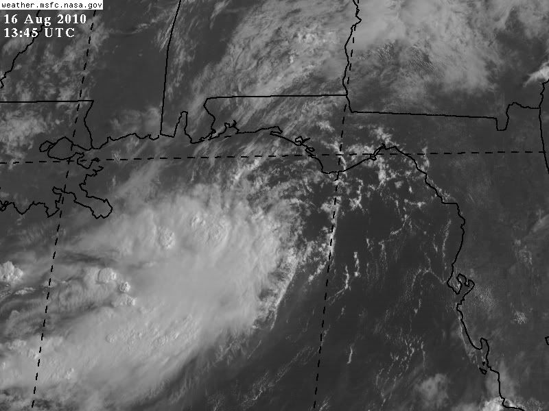
Its getting there bit by bit, the convection clearly looks sheared...again (god what a season for sheared systems!) but the LLC does look like its tigthening.
I suspect recon finds enough to support an upgrade a little later...
ATL: EX-Tropical Depression FIVE - Discussion
Moderator: S2k Moderators
0 likes
Personal Forecast Disclaimer:
The posts in this forum are NOT official forecast and should not be used as such. They are just the opinion of the poster and may or may not be backed by sound meteorological data. They are NOT endorsed by any professional institution or storm2k.org. For official information, please refer to the NHC and NWS products
The posts in this forum are NOT official forecast and should not be used as such. They are just the opinion of the poster and may or may not be backed by sound meteorological data. They are NOT endorsed by any professional institution or storm2k.org. For official information, please refer to the NHC and NWS products
-
srainhoutx

- S2K Supporter

- Posts: 6919
- Age: 68
- Joined: Sun Jan 14, 2007 11:34 am
- Location: Haywood County, NC
- Contact:
Re: ATL: EX-Tropical Depression FIVE - Discussion
0 likes
Carla/Alicia/Jerry(In The Eye)/Michelle/Charley/Ivan/Dennis/Katrina/Rita/Wilma/Ike/Harvey
Member: National Weather Association
Wx Infinity Forums
http://wxinfinity.com/index.php
Facebook.com/WeatherInfinity
Twitter @WeatherInfinity
Member: National Weather Association
Wx Infinity Forums
http://wxinfinity.com/index.php
Facebook.com/WeatherInfinity
Twitter @WeatherInfinity
-
Cryomaniac
- Category 5

- Posts: 1289
- Joined: Tue Aug 15, 2006 2:26 pm
- Location: Newark, Nottinghamshire, UK
- Contact:
-
Stormcenter
- S2K Supporter
- Posts: 6689
- Joined: Wed Sep 03, 2003 11:27 am
- Location: Houston, TX
Re:
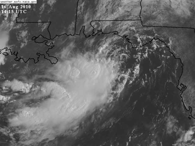
It already looks much better then it did when it was officially TD5. IMO 
Cryomaniac wrote:From the most recent images it looks like a sheared mess to my completely amateur and short sighted eyes.
0 likes
-
Cryomaniac
- Category 5
- Posts: 1289
- Joined: Tue Aug 15, 2006 2:26 pm
- Location: Newark, Nottinghamshire, UK
- Contact:
Re: Re:
Stormcenter wrote:It already looks much better then it did when it was officially TD5. IMOCryomaniac wrote:From the most recent images it looks like a sheared mess to my completely amateur and short sighted eyes.
Well yes, there is that
0 likes
-
Stormcenter
- S2K Supporter
- Posts: 6689
- Joined: Wed Sep 03, 2003 11:27 am
- Location: Houston, TX
IMO the very latest sat. loop continues to show a system becoming better organized by the hour. Now the key is will it continue throughout the day.
http://www.rap.ucar.edu/weather/satelli ... uration=12
http://www.rap.ucar.edu/weather/satelli ... uration=12
0 likes
-
breaking wind
- Tropical Low

- Posts: 30
- Joined: Sun Aug 15, 2010 7:53 pm
- Location: Lakeland FL
Re: ATL: EX-Tropical Depression FIVE - Discussion
EX-TD5 is going to remain EX-TD5. Tropical squalls with heavy bands of rain and thunderstorms but wind will not be a factor.
0 likes

Re: ATL: EX-Tropical Depression FIVE - Discussion
I agree, it looks more like a tropical depresison now than when it was numbered. I have been looking at the wind shear analysis and I don't find the high shear that has been mentioned:
It is between 5 kt and 20 kt of wind shear, 5 is favorable 20 is marginally permissive:
http://cimss.ssec.wisc.edu/tropic2/real-time/windmain.php?&basin=atlantic&sat=wg8&prod=shr&zoom=&time=
That wind shear is weakening:
http://cimss.ssec.wisc.edu/tropic2/real-time/windmain.php?&basin=atlantic&sat=wg8&prod=sht&zoom=&time=
The mid level shear is between 0 and 10 kt wich is favorable:
http://cimss.ssec.wisc.edu/tropic2/real-time/windmain.php?&basin=atlantic&sat=wg8&prod=midshr&zoom=&time=
0 likes
-
cycloneye

- Admin

- Posts: 149585
- Age: 69
- Joined: Thu Oct 10, 2002 10:54 am
- Location: San Juan, Puerto Rico
Re: ATL: EX-Tropical Depression FIVE - Discussion
Lets see what recon finds early this afternoon around 1 PM EDT.
0 likes
Visit the Caribbean-Central America Weather Thread where you can find at first post web cams,radars
and observations from Caribbean basin members Click Here
and observations from Caribbean basin members Click Here
-
HURAKAN

- Professional-Met

- Posts: 46084
- Age: 39
- Joined: Thu May 20, 2004 4:34 pm
- Location: Key West, FL
- Contact:
401
NOUS42 KNHC 161430
WEATHER RECONNAISSANCE FLIGHTS
CARCAH, NATIONAL HURRICANE CENTER, MIAMI, FL.
1030 AM EDT MON 16 AUGUST 2010
SUBJECT: TROPICAL CYCLONE PLAN OF THE DAY (TCPOD)
VALID 17/1100Z TO 18/1100Z AUGUST 2010
TCPOD NUMBER.....10-077
I. ATLANTIC REQUIREMENTS
1. NEGATIVE RECONNAISSANCE REQUIREMENTS.
2. SUCCEEDING DAY OUTLOOK.....NEGATIVE.
3. REAMRKS: MISSIONS ON TCPOD 10-076 FOR 16/1800Z
AND 17/0600Z AND 1200Z ON THE REMNANTS OF TD #5
ARE STILL PLANNED TO BE FLOWN AT THIS TIME.
II. PACIFIC REQUIREMENTS
1. NEGATIVE RECONNAISSANCE REQUIREMENTS.
2. OUTLOOK FOR SUCCEEDING DAY.....NEGATIVE.
JWP
0 likes

Re:
HURAKAN wrote:401
NOUS42 KNHC 161430
WEATHER RECONNAISSANCE FLIGHTS
CARCAH, NATIONAL HURRICANE CENTER, MIAMI, FL.
1030 AM EDT MON 16 AUGUST 2010
SUBJECT: TROPICAL CYCLONE PLAN OF THE DAY (TCPOD)
VALID 17/1100Z TO 18/1100Z AUGUST 2010
TCPOD NUMBER.....10-077
I. ATLANTIC REQUIREMENTS
1. NEGATIVE RECONNAISSANCE REQUIREMENTS.
2. SUCCEEDING DAY OUTLOOK.....NEGATIVE.
3. REAMRKS: MISSIONS ON TCPOD 10-076 FOR 16/1800Z
AND 17/0600Z AND 1200Z ON THE REMNANTS OF TD #5
ARE STILL PLANNED TO BE FLOWN AT THIS TIME.
II. PACIFIC REQUIREMENTS
1. NEGATIVE RECONNAISSANCE REQUIREMENTS.
2. OUTLOOK FOR SUCCEEDING DAY.....NEGATIVE.
JWP
can they just send a boat out there and float some balloons?
why fly a plane into this and waster valuable resources...
0 likes

Re: ATL: EX-Tropical Depression FIVE - Discussion
Still looks crummy, but the trend is that of organization. Should look better as it moves westward, so long as the upper high stays stationary.
0 likes
Re: ATL: EX-Tropical Depression FIVE - Discussion
you guys have got to give it time to stack. Shear is not the issue. Let the LLC drop down into the sw convection and align itself....
no one should have expected this to be a TS once getting back over water...
no one should have expected this to be a TS once getting back over water...
0 likes
-
Aric Dunn
- Category 5
- Posts: 21238
- Age: 43
- Joined: Sun Sep 19, 2004 9:58 pm
- Location: Ready for the Chase.
- Contact:
it will be interesting to see if they upgrade... at this time with its present condition i dont think they will. recon will probably find a decent LLC but the winds are barely even 25kts.. and the shear is high. unless they see a good chance the shear will decrease I think they will hold off till something changes.
0 likes
-
Stormcenter
- S2K Supporter
- Posts: 6689
- Joined: Wed Sep 03, 2003 11:27 am
- Location: Houston, TX
Re: ATL: EX-Tropical Depression FIVE - Discussion
I really think many (but not me) did believe this would be a TS immediately once this hit the GOM.
It just doesn't work that way.
It just doesn't work that way.
ROCK wrote:you guys have got to give it time to stack. Shear is not the issue. Let the LLC drop down into the sw convection and align itself....
no one should have expected this to be a TS once getting back over water...
0 likes

Re: ATL: EX-Tropical Depression FIVE - Discussion
Looks to be some kind of center...either an MLC or a poorly defined LLC...due south of Panama City Beach. I would suspect this is close to the regeneration of TD Five. It is probably a tossup of whether or not this will become Danielle...there seems to be some northerly shear (although probably not too disruptive)...and dry air off the land might be playing some impact. My guess is that this will become Danielle, although probably not more than 50 mph. If this had more time, it would probably become a hurricane, but it will likely move inland before it really can ramp up.
0 likes
-
Stormcenter
- S2K Supporter
- Posts: 6689
- Joined: Wed Sep 03, 2003 11:27 am
- Location: Houston, TX
Re:
It won't take much to be classified a TD again.
Aric Dunn wrote:it will be interesting to see if they upgrade... at this time with its present condition i dont think they will. recon will probably find a decent LLC but the winds are barely even 25kts.. and the shear is high. unless they see a good chance the shear will decrease I think they will hold off till something changes.
0 likes
-
SunnyThoughts
- Category 5
- Posts: 2263
- Joined: Wed Jul 09, 2003 12:42 pm
- Location: Pensacola, Florida
Re: ATL: EX-Tropical Depression FIVE - Discussion
Radar loop showing the spin http://radar.weather.gov/radar.php?rid=MOB&product=N0Z&overlay=11101111&loop=yes
0 likes
Who is online
Users browsing this forum: No registered users and 36 guests