Disturbed weather in Eastern Atlantic (Is invest 95L)
Moderator: S2k Moderators
Forum rules

The posts in this forum are NOT official forecasts and should not be used as such. They are just the opinion of the poster and may or may not be backed by sound meteorological data. They are NOT endorsed by any professional institution or STORM2K. For official information, please refer to products from the National Hurricane Center and National Weather Service.
-
Ivanhater

- Storm2k Moderator

- Posts: 11221
- Age: 39
- Joined: Fri Jul 01, 2005 8:25 am
- Location: Pensacola
Re: Wave PGI-30L in Eastern Atlantic (Models develop it)
The first wave looks to be on a WNW heading between 216 and 240 hours
0 likes
Michael
-
hurricaneCW
- Category 5

- Posts: 1799
- Joined: Wed Mar 03, 2010 6:20 am
- Location: Toms River, NJ
Re: Wave PGI-30L in Eastern Atlantic (Models develop it)
So what's the main difference between the gfs and euro. The speed of the wave/storm or which wave develops into the storm seen on the Euro and Gfs model runs.
0 likes

ECM suggests a probable recurve but it looks like its producing a major hurricane now for this system, pretty impressive actually!
All depends on how quickly this one gets going and also what happens in the W.Atlantic, which is a very messy set-up by 144-192hrs.
As for the system behind...thats the one to watch, its weak but its also low latitude and thus obviously a risk down the line...
All depends on how quickly this one gets going and also what happens in the W.Atlantic, which is a very messy set-up by 144-192hrs.
As for the system behind...thats the one to watch, its weak but its also low latitude and thus obviously a risk down the line...
0 likes
Personal Forecast Disclaimer:
The posts in this forum are NOT official forecast and should not be used as such. They are just the opinion of the poster and may or may not be backed by sound meteorological data. They are NOT endorsed by any professional institution or storm2k.org. For official information, please refer to the NHC and NWS products
The posts in this forum are NOT official forecast and should not be used as such. They are just the opinion of the poster and may or may not be backed by sound meteorological data. They are NOT endorsed by any professional institution or storm2k.org. For official information, please refer to the NHC and NWS products
Per the above map the subtropical high is still being bumped by that polar trough over eastern Canada, though is now also being squeezed by the European trough (actually both troughs have sharpened), so that's also a very important factor over the days to come - it seems (per some maps) that the high might be stronger in the mid-Atlantic and weaker elsewhere, so very important for whatever does form...
Frank
Frank
0 likes
-
cycloneye

- Admin

- Posts: 149601
- Age: 69
- Joined: Thu Oct 10, 2002 10:54 am
- Location: San Juan, Puerto Rico
Re: Wave PGI-30L in Eastern Atlantic (Models develop it)
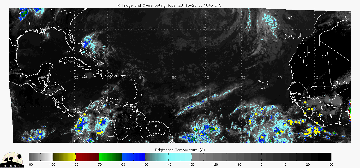
Here is a big panoramic view of the three test invests and the system soon to emerge Africa. The yellow dots are overshooting tops of clouds.
0 likes
Visit the Caribbean-Central America Weather Thread where you can find at first post web cams,radars
and observations from Caribbean basin members Click Here
and observations from Caribbean basin members Click Here
-
hurricaneCW
- Category 5
- Posts: 1799
- Joined: Wed Mar 03, 2010 6:20 am
- Location: Toms River, NJ
Re: Wave PGI-30L in Eastern Atlantic (Models develop it)
Well at this point, it's too early to say they will fish. It's too early to say that they will even develop. I assume that the consistent model runs showing development will come into fruition and we'll actually get a storm. I assume the 2nd second is the one over western Africa right now, the one that has the best chance of making it across.
Another few days of waiting for an invest or TD to pop up, hopefully.
Another few days of waiting for an invest or TD to pop up, hopefully.
0 likes
-
Ivanhater
- Storm2k Moderator
- Posts: 11221
- Age: 39
- Joined: Fri Jul 01, 2005 8:25 am
- Location: Pensacola
Re: Wave PGI-30L in Eastern Atlantic (Models develop it)
East coast trough is weaker compared to the 00z run last night which is why we are seeing a WNW motion at the end instead of a sharp recurve...both systems could be trouble down the road
0 likes
Michael

Re: Wave PGI-30L in Eastern Atlantic (Models develop it)
Im lost as to which models are developing which system. The CMC and GFS seem to develop the first wave from PGI-30L, while the NOGAPS and ECMWF seem to develop the wave behind it, which is still over Africa.
0 likes
Yeah Ivanhater its not as strong, the system is pretty powerful by 240hrs as well, probably a cat-3/4 by that time...
Pattern probably still does suggest a recurve before 70W on this run but its trended south/west at least since last nights run.
BigA...only nogaps doesn't form the first wave....and infact its a fusion between an ITCZ/TW. The exact evolution to this is pretty key IMO...the faster it kicks westwards the bigger the threat down the road.
0 likes
Personal Forecast Disclaimer:
The posts in this forum are NOT official forecast and should not be used as such. They are just the opinion of the poster and may or may not be backed by sound meteorological data. They are NOT endorsed by any professional institution or storm2k.org. For official information, please refer to the NHC and NWS products
The posts in this forum are NOT official forecast and should not be used as such. They are just the opinion of the poster and may or may not be backed by sound meteorological data. They are NOT endorsed by any professional institution or storm2k.org. For official information, please refer to the NHC and NWS products
-
Ivanhater
- Storm2k Moderator
- Posts: 11221
- Age: 39
- Joined: Fri Jul 01, 2005 8:25 am
- Location: Pensacola
Re:
KWT wrote:Yeah Ivanhater its not as strong, the system is pretty powerful by 240hrs as well, probably a cat-3/4 by that time...
Pattern probably still does suggest a recurve before 70W on this run but its trended south/west at least since last nights run.
BigA...only nogaps doesn't form the first wave....and infact its a fusion between an ITCZ/TW. The exact evolution to this is pretty key IMO...the faster it kicks westwards the bigger the threat down the road.
That is the key KWT. Both the GFS and Euro are hinting at a weaker trough and lifting out quicker. The WNW motion between 216 and 240 hours is interesting. Yesterday was showing a much sharper turn.
0 likes
Michael
-
ColinDelia

- S2K Supporter

- Posts: 918
- Joined: Mon Aug 29, 2005 5:52 am
- Location: The Beach, FL
Looking at the model animation of the GFS 850 mb vorticity it looks like what is being developed is currently south of the CV islands.
http://moe.met.fsu.edu/cgi-bin/gfstc2.c ... =Animation
http://moe.met.fsu.edu/cgi-bin/gfstc2.c ... =Animation
0 likes
-
cycloneye
- Admin
- Posts: 149601
- Age: 69
- Joined: Thu Oct 10, 2002 10:54 am
- Location: San Juan, Puerto Rico
Re: Wave PGI-30L in Eastern Atlantic (Models develop it)
Hey peeps, I may have found something that may take away the confusion about these waves and which one may develop. Below is a synopsis discussion about the test invests PGI-30L and PGI-31L.
http://catalog.eol.ucar.edu/cgi-bin/pre ... opsis.html
http://catalog.eol.ucar.edu/cgi-bin/pre ... opsis.html
PREDICT pouch synopsis
--------------------------------------------------------------------------------
Date (UTC): 2010/08/17 15:22
Author: Boothe
Submitted at (UTC): 2010/08/17 15:42
Revised at(UTC): 2010/08/17 15:55
--------------------------------------------------------------------------------
Pouch Name: PGI31L Official Name: Initial Center Point: 13N 33W
Notes:
WORD OF CAUTION!
I don't usually initiate a pouch that is developing in the
horizontal shear zone in the middle of the Atlantic; however,
the models not only develop a pouch that interacts with nearby
PGI30L, but also ends up more intense than PGI30L.
Although PGI31L is intense at the end of the forecast in most
models, it is not at analysis, and determining its initial
position is troublesome. THERE IS A HIGH AMOUNT OF UNCERTAINTY
IN THE FIRST 24 HOURS FOR THE POSITIONS. Essentially, a large
circulation ~35W is apparent in the analysis. I did position
PGI31L in that large circulation in GFS; however, it becomes
fairly apparent that while that large circulation actually
weakens and creeps westward, a cyclonic area to the east is what
develops. So, some of the models appear to jump to the east for
that reason. (In hindsight, I probably should have initiated
PGI31L farther east.)
That being said, the models (except NOGAPS) do indicate a bit of
eastward motion in the beginning during a Fujiwhara with PGI30L,
followed by westward motion. For that reason, I simply used a
PHASE SPEED OF ZERO m/s.
--------------------------------------------------------------------------------
ECMWF: Phase Speed: Determination: Level tracked:
I did not put positions on the larger, weak circulation to the
west (which I thought would be the initial position) ... only
the smaller circulation to the east that later develops. For
that reason, the map is shifted too far west, and the developing
PGI31L is off the eastern edge of the map.
GFS: Phase Speed: Determination: Level tracked:
I put the initial position on the larger, weak circulation to
the west (~35W), but then I jump to the rapidly developing
system to the east; hence the unrealistic jump to the east.
PGI31L becomes more intense than PGI30L by the end of the
forecast.
UKMET: Phase Speed: Determination: Level tracked:
Similar to GFS.
NOGAPS: Phase Speed: Determination: Level tracked:
Here is where I got really inconsistent! I tracked only the
weaker western circulation, which creeps westward and quickly
dissipates. However, there's a reason. Although NOGAPS does
develop a non-PGI30L pouch, it is much farther east ... east of
PGI30L (see the fields for PGI30L). I'm not sure if it is
simply an ITCZ development or the next wave coming off of
Africa, but I am sure that I could not jump PGI31L THAT FAR
east!
0 likes
Visit the Caribbean-Central America Weather Thread where you can find at first post web cams,radars
and observations from Caribbean basin members Click Here
and observations from Caribbean basin members Click Here
-
CrazyC83
- Professional-Met

- Posts: 34315
- Joined: Tue Mar 07, 2006 11:57 pm
- Location: Deep South, for the first time!
Re: Wave PGI-30L in Eastern Atlantic (Models develop it)
cycloneye wrote:Here is a big panoramic view of the three test invests and the system soon to emerge Africa. The yellow dots are overshooting tops of clouds.
Test invests? So this is 80L then? I knew they used 80s for test systems, but didn't think they did it on a soon-to-be-real Invest...
0 likes
-
Aric Dunn
- Category 5
- Posts: 21238
- Age: 43
- Joined: Sun Sep 19, 2004 9:58 pm
- Location: Ready for the Chase.
- Contact:
well I noticed something I did not before.. the relative locations of 30 and 31 are very close such that they are already interacting and any development of either will almost certainly be in part due to a this interaction. So the debate about which one forms is rather ambiguous. Clearly 30 is not moving west much ( if at all ) since its somewhere stuck in the flow from the ITCZ into the larger amplitude to its east. 31 is in a moist low level environment but there is dry air in the mid levels that far north as is typical from the sal. 31 and 30 will interact in a semi predictable way with a transfer of vorticity (energy) into the ICTZ and 30 with this help in development ... who knows... all that can be said is that when all is said and done the larger wave will likely be discernible from the other and the interaction will be focused along the area of greatest convergence ( convection ) which in this case farther south towards the ITCZ. 31 does not seem to be digging south to the are where the models see development this leads me to believe that the interaction is the culprit behind all the models ( the models just do not have the resolution to differentiate two closely interacting waves very well) since timing and position seem to differ enough between the models. The fact that 30L is basically not moving and 31L is farther north and moving faster is a very typical setup this time of year. If you remember a similar debate as to which wave would eventually form chris and in that case it was the larger wave that interacted with the slower and smaller leading wave. the atmosphere is not so clear cut and you cant say "any" wave formed on its own.
with all this (rambling ) said I can tell you one thing for sure... 31 will not develop with no convection !! lol
with all this (rambling ) said I can tell you one thing for sure... 31 will not develop with no convection !! lol
0 likes
Note: If I make a post that is brief. Please refer back to previous posts for the analysis or reasoning. I do not re-write/qoute what my initial post said each time.
If there is nothing before... then just ask
Space & Atmospheric Physicist, Embry-Riddle Aeronautical University,
I believe the sky is falling...
If there is nothing before... then just ask
Space & Atmospheric Physicist, Embry-Riddle Aeronautical University,
I believe the sky is falling...
-
Ivanhater
- Storm2k Moderator
- Posts: 11221
- Age: 39
- Joined: Fri Jul 01, 2005 8:25 am
- Location: Pensacola
Re: Wave PGI-30L in Eastern Atlantic (Models develop it)
Here is the difference between last night's run and today's..
Notice the trend in the East coast trough. Not looking at specifics right now, but the trend with the GFS and Euro are showing a less amplified trough.


Notice the trend in the East coast trough. Not looking at specifics right now, but the trend with the GFS and Euro are showing a less amplified trough.
0 likes
Michael
-
ColinDelia
- S2K Supporter
- Posts: 918
- Joined: Mon Aug 29, 2005 5:52 am
- Location: The Beach, FL
Re: Wave PGI-30L in Eastern Atlantic (Models develop it)
KWT, I think you were looking at the vorticity in the ECMWF runs at the same time I was looking at the GFS. I've been watching this for about half an hour straight and it looks to me like the GFS develops mostly 31 but maybe there is some smaller contribution from 30. You see basically the same in the ECMWF?
0 likes
-
ColinDelia
- S2K Supporter
- Posts: 918
- Joined: Mon Aug 29, 2005 5:52 am
- Location: The Beach, FL
Great post Aric, that makes sense to me as well and its what I've been thinking...
Interestingly though interaction maybe key for the track as well...this is because the GFS takes this quickly enough to the west to stay under the upper high right through to about 60W and because of that when it does start to lift out it doesn't get totally recurved. The ECM does the same thing but is a good deal further east and thus is only a threat to Bermuda...
That 24-36hrs of extra westward motion the GFS has makes quite a large difference!
0 likes
Personal Forecast Disclaimer:
The posts in this forum are NOT official forecast and should not be used as such. They are just the opinion of the poster and may or may not be backed by sound meteorological data. They are NOT endorsed by any professional institution or storm2k.org. For official information, please refer to the NHC and NWS products
The posts in this forum are NOT official forecast and should not be used as such. They are just the opinion of the poster and may or may not be backed by sound meteorological data. They are NOT endorsed by any professional institution or storm2k.org. For official information, please refer to the NHC and NWS products
-
Aric Dunn
- Category 5
- Posts: 21238
- Age: 43
- Joined: Sun Sep 19, 2004 9:58 pm
- Location: Ready for the Chase.
- Contact:
Re: Wave PGI-30L in Eastern Atlantic (Models develop it)
Ivanhater wrote:Here is the difference between last night's run and today's..
Notice the trend in the East coast trough. Not looking at specifics right now, but the trend with the GFS and Euro are showing a less amplified trough.
you need to adjust the 12z run by 12 hours since the 240 hours from the 00z run is not the same as the 240 hours from the 12z
0 likes
-
Ivanhater
- Storm2k Moderator
- Posts: 11221
- Age: 39
- Joined: Fri Jul 01, 2005 8:25 am
- Location: Pensacola
Re: Wave PGI-30L in Eastern Atlantic (Models develop it)
Well Aric, that is as close as I can get it with these maps when there is a 24 hour spread. In the maps above it is 12 hours apart and gives the the idea of the weaker trough.
0 likes
Michael
Who is online
Users browsing this forum: Ulf, Yellow Evan and 133 guests