"An active Atlantic hurricane period coming" - Jeff Masters
Moderator: S2k Moderators
Forum rules

The posts in this forum are NOT official forecasts and should not be used as such. They are just the opinion of the poster and may or may not be backed by sound meteorological data. They are NOT endorsed by any professional institution or STORM2K. For official information, please refer to products from the National Hurricane Center and National Weather Service.
-
StormClouds63
- Category 2

- Posts: 583
- Age: 62
- Joined: Tue May 13, 2008 11:56 am
- Location: Southwest Louisiana
Re: "An active Atlantic hurricane period coming" - Jeff Masters
The next 6 weeks will determine the 2010 hurricane season. The peak of the season may be later than September 10, but will not be in the month of October. As CZ said 2-3 weeks ago, the date for activity to "ramp up" keeps being pushed further and further back. The clock continues ticking on the 2010 season.
0 likes


Re:
KWT wrote:We will see CZ, remember 1961 that had nothing in August at all and then went mental in September...
Given both the ECM and CFS long range models are picking up on the same hyperactive period in September, it'll be worth keeping a close eye on...
Also FWIW I feel the CFS has done surprisingly well, it didn't show much at all for the first half of August which looks to have been a good call.
Carla came crashing in onto the Texas coast.
0 likes

Re: "An active Atlantic hurricane period coming" - Jeff Masters
StormClouds63 wrote:The next 6 weeks will determine the 2010 hurricane season. The peak of the season may be later than September 10, but will not be in the month of October. As CZ said 2-3 weeks ago, the date for activity to "ramp up" keeps being pushed further and further back. The clock continues ticking on the 2010 season.
2005 FWIW had its peak in October so it can happen, of course 2005 was a mental year, but you can get some good stuff in October/November still...just 2 years ago we had major hurricane Omar and Paloma in those months.
0 likes
Personal Forecast Disclaimer:
The posts in this forum are NOT official forecast and should not be used as such. They are just the opinion of the poster and may or may not be backed by sound meteorological data. They are NOT endorsed by any professional institution or storm2k.org. For official information, please refer to the NHC and NWS products
The posts in this forum are NOT official forecast and should not be used as such. They are just the opinion of the poster and may or may not be backed by sound meteorological data. They are NOT endorsed by any professional institution or storm2k.org. For official information, please refer to the NHC and NWS products
-
aerology
- Tropical Depression

- Posts: 56
- Age: 78
- Joined: Sun Oct 18, 2009 2:38 am
- Location: Concordia, Kansas
- Contact:
The posts in this forum are NOT official forecast and should not be used as such. They are just the opinion of the poster and may or may not be backed by sound meteorological data. They are NOT endorsed by any professional institution or storm2k.org. For official information, please refer to the NHC and NWS products.
In case you all need a little comic relief, Just some of my ideas...I thought I would post this in here...let me know later if this ends up better than a dart board approach, I was forecasting 8-3-3 for this year. (10 to 1 I get banned)
2010 detailed Hurricane forecast
Current mood: adventurous
Back on the 15th. I climbed out on a big limb, with chainsaw in tow, with this forecast?
There are four ingredients needed to make a large storm, available heat energy, moisture to change phase states to generate the low pressure zone, ion potentials to drive the “precipitation” (not just condensation), and a global lunar tidal effect to drive the wind patterns that tighten up, as the tropical air mass that becomes the tropical storm, moves off of the ITCZ and further away from the equator, the Coriolis effect kicks in and strengthens, to assist the formation of the cyclonic circulation along with the associated ionic drives.
We have been having three of these ingredients showing up in the three named disturbances so far. However the global “pole to equator ion charge gradient” is currently stagnating, all of the seasonal drivers of these shifts in charge gradients will occur later in the year than is the”Normal” (although nonrandom pattern of distribution.)
The solar cycle has been slow, but is starting to pick up as we approach the heliocentric conjunctions of three of the four outer planets that drive the global ion potentials that create and drive these large storms. I have posted a detailed forecast of the dates to expect these storms to be produced several time over the past year.
Due to the geomagnetic effects of the increased coupling, of the solar fields extended out from flares and coronal holes, as the Earth passes through the focused area that lines up heliocentrically with the outer planets:
Neptune on the 20th of August, the Earth will have an increased homopolar generator charge potential inducted into it, then relaxed over the next two weeks (till end of August 2010) that will induce the typical discharge pattern that generates the large flows of ions that allow the global tropical storms to attain sizable effects above cat 1 – cat 2 levels, because of increased wind and precipitation production, powered by the enhanced action of the opposing ion charges swept into the cyclonic flow structure.
September 21st through 24th 2010 will see the bigger set of conjunctions that will do a much better job of driving the intensity of resultant global tropical and extra-tropical storms, that form on the discharge side of the ion flux patterns, after these dates.
No the season is not over yet.
The lunar declinational tides that peak at the culmination of the declinational sweep occur at Maximum South on 19th August then heads North with tropical moisture in tow until the effects has run its course by the 2nd to 4th of September 2010, is the window of opportunity for the first weaker outbreak of global TS.
The lunar declination is Maximum South again on the 15th of September 2010, ahead of the peak of charging of the Uranus / Jupiter heliocentric conjunction of the 24th of September 2010, and it should be in phase with the movement of tropical moisture laden warm air crossing the equator following the moon, as it moves North across the equator on the 23rd of September.
The same day of the peak charging effects of the homopolar generator as the Earth responds to the increased inductive effects carried on the solar wind to affect the coupling through to the outer planets from the sun out of a large coronal hole created on the sun just for the purpose of providing the magnetic field energy needed. This powers up the cycle of positive ion charging along the ITCZ, by pushing more moisture into the lower atmosphere, to then add drive to the ion discharging phase, driving the resultant outbreak of global wide intense tropical storms, that will occur post conjunction.
By the time the Moon reaches maximum North declination on the 29th of September 2010, the global ACE values will be close to peak for the year. Inertial momentum of the global systems should carry on the enhanced zonal flow through the next two weeks.
With the continual decreasing electromagnetic coupling as the Earth moves past these outer planets the severe weather activity levels, will drop with continued attempted recovery enhancements at the lunar declinational culminations, until by the time of the synod conjunction of Venus and Earth on the 29th of October 2010, we will see a last hurrah, then a slow shift into the storms of a deep cold NH winter.
Richard Holle
0 likes
Re: "An active Atlantic hurricane period coming" - Jeff Masters
KWT wrote:
2005 FWIW had its peak in October so it can happen, of course 2005 was a mental year, but you can get some good stuff in October/November still...just 2 years ago we had major hurricane Omar and Paloma in those months.
A 2005 type season likely happens every 50 to 80 years. The other season like 2005 were likely 1887 and 1933. 2008 was very active too and was bad for the basin. As you say this season will probably be more like 1961, 1998, and 1999.
0 likes

>>Haven't we heard this song before?
What song would that be, that the pattern is about to flip? Yeah, I've kind of been patiently waiting to follow that for a while. It doesn't happen usually until later into August. Often posters, one of whom hails from my hometown and posts here mistake that for cold fronts that have officially ended the season. Happened in 2005. Happened again in 2008. They missed the signal (which will be different in 2010). But that's because the dismal forums at WWL promoted the season wrap-up and it unfortunately bled over here. Oh yeah, then came Katrina and Rita in 2005, and Gustav and Ike in 2008. This year, the biggest signal will be high pressure setting up in the North Atlantic and the eastern provinces of Canada possibly all the way over to Quebec. CMC is finally seeing it within a week (though that could still be a few days early - it may just be sniffing out where the North Atlantic pattern is heading). Who knows if that pattern is going to hold and for how long. But that's where we've been heading for a while. It was just about patience.
>>After all it's very obvious this season is not following
the script at all.
It's completely following the script. The signals have been there all along. But some combination of too much caffeine and ADHD issues infected the board since mid-June and allowed a lot of posters to fall into a trap. It happens every season with this one being just a bit more vocal because of some of the early prognostications that apparently made a lot of people assume we'd be reliving 2005 all over again. However, if I may speak for whichever realists there are here besides me, we've been seeing the circular upper level lows moving east to west, we've been monitoring SSTA's, we've been looking at SAL and pressure and the rest of whatever indications there are. And you know what? It seems like we're right where we are supposed to be - between the C and D storm with 2 weeks left to go in August. Script? Seems like a reasonable one to me.
>>They way I undestood it we were going to have storms forming left and right from the get go like 2005.
See I don't know where you got that from. Unless there's anyone on the site older than my dad (77 and born in 1933), none of us have ever seen 2005 before 2005. And most of us probably won't see that ever again. I mean come on. August finished up with the "L" storm (Lee?). L is the 12th letter of the alphabet. 12 is more than an average season. And we were there by August. Who (and I'd like names or a link) among the worst doomsdayers made such a prediction in such a way that you would understand that's the way the season would run? I didn't see that from anyone with any credibility, and I read many, many seasonal forecasts. Seems like your idea of what the season might be took on a life of its own and translated into some of your posts. You're a good poster, so I'm not looking to cheapshot you. I'm just curious. I realize that 2005 is an analog or an almost-analog in many of the forecasts. But not much of the upper patterns resemble 2005. And frankly, the tracks (with the exception of Colin) haven't much mirrored what is supposed to be the closest analog - 14 named storm season 1998. So the season will be documented as it progresses and we can worry about the body counter November 30th.
Patience bra.
0 likes

Re: "An active Atlantic hurricane period coming" - Jeff Masters
ROCK wrote:Dr Master's is right on with his take....you can see it in every long range model...We could be tracking 3 storms at one time next week...
Where do you see these 3 storms for next week?
0 likes

Re: "An active Atlantic hurricane period coming" - Jeff Masters
LaBreeze wrote:ROCK wrote:Dr Master's is right on with his take....you can see it in every long range model...We could be tracking 3 storms at one time next week...
Where do you see these 3 storms for next week?
look at the models....We COULD be seeing an up tick in activity...
0 likes

Re: Re:
fwbbreeze wrote:Opal in 95 was a pretty potent hurricane that affected mainland us in OCTOBER! I have been on this site a long time and I have never seen so much worthless speculation about the so called "bust" of a season.
Yup - I agree with you Kent. I get irritated with this type of posting as well - which is why I've mainly gone to, as you tease me about - lurking here!
A look back at 1992 - with a total of seven storms - I guess this was a 'bust' as well?
# Name Date Wind Pres Cat
1 Subtropical Storm 1 21-24 APR 45 1002 -
2 Hurricane ANDREW 16-28 AUG 150 922 5
3 Hurricane BONNIE 17 SEP- 2 OCT 95 965 2
4 Hurricane CHARLEY 21-29 SEP 95 965 2
5 Tropical Storm DANIELLE 22-26 SEP 55 1001 -
6 Tropical Storm EARL 26 SEP- 3 OCT 55 990 -
7 Hurricane FRANCES 22-30 OCT 75 976 1
0 likes
-
Stormcenter
- S2K Supporter

- Posts: 6685
- Joined: Wed Sep 03, 2003 11:27 am
- Location: Houston, TX
Re: Re:
Opal was a rarity just like 2005.
The "bust" that is being referred to is based on the
number and not the quality of the storms so far
this season. We all know we still could see a "Andrew"
type storm or storms this season.
The "bust" that is being referred to is based on the
number and not the quality of the storms so far
this season. We all know we still could see a "Andrew"
type storm or storms this season.
sunny wrote:fwbbreeze wrote:Opal in 95 was a pretty potent hurricane that affected mainland us in OCTOBER! I have been on this site a long time and I have never seen so much worthless speculation about the so called "bust" of a season.
Yup - I agree with you Kent. I get irritated with this type of posting as well - which is why I've mainly gone to, as you tease me about - lurking here!
A look back at 1992 - with a total of seven storms - I guess this was a 'bust' as well?
# Name Date Wind Pres Cat
1 Subtropical Storm 1 21-24 APR 45 1002 -
2 Hurricane ANDREW 16-28 AUG 150 922 5
3 Hurricane BONNIE 17 SEP- 2 OCT 95 965 2
4 Hurricane CHARLEY 21-29 SEP 95 965 2
5 Tropical Storm DANIELLE 22-26 SEP 55 1001 -
6 Tropical Storm EARL 26 SEP- 3 OCT 55 990 -
7 Hurricane FRANCES 22-30 OCT 75 976 1
0 likes
Re: Re:
Stormcenter wrote:Opal was a rarity just like 2005.
The "bust" that is being referred to is based on the
number and not the quality of the storms so far
this season. We all know we still could see a "Andrew"
type storm or storms this season.
Personally, I see a season with few storms as a 'success', not a bust.
0 likes
-
Stormcenter
- S2K Supporter
- Posts: 6685
- Joined: Wed Sep 03, 2003 11:27 am
- Location: Houston, TX
Re: Re:
Well personally I agree 100% but for those who make
a living doing that kind stuff it's a bust when what they
predict doesn't pan out.
a living doing that kind stuff it's a bust when what they
predict doesn't pan out.
sunny wrote:Stormcenter wrote:Opal was a rarity just like 2005.
The "bust" that is being referred to is based on the
number and not the quality of the storms so far
this season. We all know we still could see a "Andrew"
type storm or storms this season.
Personally, I see a season with few storms as a 'success', not a bust.
0 likes
Re: Re:
Stormcenter wrote:Well personally I agree 100% but for those who make
a living doing that kind stuff it's a bust when what they
predict doesn't pan out.
The definition of 'forecast' is to estimate or calculate in advance. It is not absolute.
The perception of disappointment expressed by many at the lack of storms is disconcerting. I'm not pointing a finger at you, I just wish folks would think a little more before they post.
0 likes
>Well personally I agree 100% but for those who make
a living doing that kind stuff it's a bust when what they
predict doesn't pan out.
That's great and all, but you didn't address the fact that you yourself said that it was the way you undestood it. Unless the season is over, I don't know how you can be so adamant about everyone busting their forecasts. Again, I have no idea and my only dog in the fight is not wanting to have to evacuate this year. But I'd like you to come clean on this.
0 likes

-
Decomdoug

- Tropical Storm

- Posts: 177
- Age: 73
- Joined: Sun Aug 29, 2004 8:34 am
- Location: Port St. Lucie, Florida
We are just days away from what Joe B calls "an upcoming frenzy of storms, days with two or three storms on the chart." 
http://www.accuweather.com/blogs/news/s ... t-trop.asp
http://www.accuweather.com/blogs/news/s ... t-trop.asp
0 likes
-
Ikester
- Professional-Met

- Posts: 361
- Age: 40
- Joined: Mon Jun 21, 2010 5:00 pm
- Location: Jacksonville, FL
Re: Re:
sunny wrote:fwbbreeze wrote:Opal in 95 was a pretty potent hurricane that affected mainland us in OCTOBER! I have been on this site a long time and I have never seen so much worthless speculation about the so called "bust" of a season.
Yup - I agree with you Kent. I get irritated with this type of posting as well - which is why I've mainly gone to, as you tease me about - lurking here!
A look back at 1992 - with a total of seven storms - I guess this was a 'bust' as well?
# Name Date Wind Pres Cat
1 Subtropical Storm 1 21-24 APR 45 1002 -
2 Hurricane ANDREW 16-28 AUG 150 922 5
3 Hurricane BONNIE 17 SEP- 2 OCT 95 965 2
4 Hurricane CHARLEY 21-29 SEP 95 965 2
5 Tropical Storm DANIELLE 22-26 SEP 55 1001 -
6 Tropical Storm EARL 26 SEP- 3 OCT 55 990 -
7 Hurricane FRANCES 22-30 OCT 75 976 1
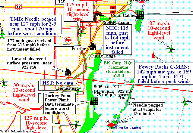
For the record, Andrew's winds were officially 165 mph. That is what it was adjusted to after the anamometer broke at the NHC with the gauge stuck on 165 mph and climbing as the eyewall was just getting ready to push in.
Neat Graphic:
0 likes
Re: Re:
[quote="Ikester"]
For the record, Andrew's winds were officially 165 mph. That is what it was adjusted to after the anamometer broke at the NHC with the gauge stuck on 165 mph and climbing as the eyewall was just getting ready to push in.
Feel free to correct Unisys on this I was looking for the number of storms for the year....but the NHC has winds for Andrew at 145.
The maximum sustained surface wind speed (1-min average at 10 meters [about 33 ft] elevation) during landfall over Florida is estimated at 125 kt (about 145 mph), with gusts at that elevation to at least 150 kt (about 175 mph).
http://www.nhc.noaa.gov/1992andrew.html
For the record, Andrew's winds were officially 165 mph. That is what it was adjusted to after the anamometer broke at the NHC with the gauge stuck on 165 mph and climbing as the eyewall was just getting ready to push in.
Feel free to correct Unisys on this
The maximum sustained surface wind speed (1-min average at 10 meters [about 33 ft] elevation) during landfall over Florida is estimated at 125 kt (about 145 mph), with gusts at that elevation to at least 150 kt (about 175 mph).
http://www.nhc.noaa.gov/1992andrew.html
Last edited by sunny on Wed Aug 18, 2010 1:01 pm, edited 1 time in total.
0 likes
-
Stormcenter
- S2K Supporter
- Posts: 6685
- Joined: Wed Sep 03, 2003 11:27 am
- Location: Houston, TX
Re:
It's funny how the target(start date) keeps on moving up.
Anyway it's inevitable that we will see a spike just because
of the time of the year.
Anyway it's inevitable that we will see a spike just because
of the time of the year.
Decomdoug wrote:We are just days away from what Joe B calls "an upcoming frenzy of storms, days with two or three storms on the chart."
http://www.accuweather.com/blogs/news/s ... t-trop.asp
0 likes
Who is online
Users browsing this forum: No registered users and 74 guests