Disturbed weather in Eastern Atlantic (Is invest 95L)

This is the general tropical discussion area. Anyone can take their shot at predicting a storms path.

Moderator: S2k Moderators

Forum rules

The posts in this forum are NOT official forecasts and should not be used as such. They are just the opinion of the poster and may or may not be backed by sound meteorological data. They are NOT endorsed by any professional institution or STORM2K. For official information, please refer to products from the National Hurricane Center and National Weather Service.

Help Support Storm2K
Message
Author
User avatar
Fego
S2K Supporter
S2K Supporter
Posts: 767
Age: 65
Joined: Sun Apr 18, 2004 7:58 pm
Location: San Juan, Puerto Rico
Contact:

Re: Waves 30L/ 31L in Eastern Atlantic

#1041 Postby Fego » Wed Aug 18, 2010 5:25 pm

Image

Uploaded with ImageShack.us

Going wnw... looks like the the ridge colapsed imo.
0 likes   
Go Giants! Go Niners! Go Warriors!

User avatar
Vortex
S2K Supporter
S2K Supporter
Posts: 4644
Age: 53
Joined: Fri Aug 01, 2003 9:34 pm
Location: Hilton Head, SC

#1042 Postby Vortex » Wed Aug 18, 2010 5:27 pm

and there she goes...next....
0 likes   

User avatar
Vortex
S2K Supporter
S2K Supporter
Posts: 4644
Age: 53
Joined: Fri Aug 01, 2003 9:34 pm
Location: Hilton Head, SC

#1043 Postby Vortex » Wed Aug 18, 2010 5:31 pm

With this pattern be an early fall for the NE and may need to wait until October for any serious threats....
0 likes   

User avatar
Fego
S2K Supporter
S2K Supporter
Posts: 767
Age: 65
Joined: Sun Apr 18, 2004 7:58 pm
Location: San Juan, Puerto Rico
Contact:

Re: Waves 30L/ 31L in Eastern Atlantic

#1044 Postby Fego » Wed Aug 18, 2010 5:32 pm

Lets see what the long range shows in terms of other systems.
0 likes   
Go Giants! Go Niners! Go Warriors!

User avatar
Vortex
S2K Supporter
S2K Supporter
Posts: 4644
Age: 53
Joined: Fri Aug 01, 2003 9:34 pm
Location: Hilton Head, SC

#1045 Postby Vortex » Wed Aug 18, 2010 5:32 pm

If this verifies the Extended CFS has been on the money....
0 likes   

OURAGAN
Category 1
Category 1
Posts: 451
Joined: Sat Aug 07, 2004 12:18 pm
Location: GUADELOUPE

Re: Waves 30L/ 31L in Eastern Atlantic

#1046 Postby OURAGAN » Wed Aug 18, 2010 5:37 pm

Good shape between 30 and 35 W

Image
0 likes   

User avatar
cycloneye
Admin
Admin
Posts: 145308
Age: 68
Joined: Thu Oct 10, 2002 10:54 am
Location: San Juan, Puerto Rico

Re: Waves 30L/ 31L in Eastern Atlantic

#1047 Postby cycloneye » Wed Aug 18, 2010 5:41 pm

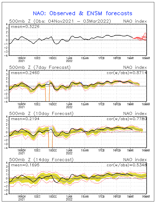
Weaker high pressure equals negative NAO and that is forecast for the next 2 weeks.

Image
0 likes   
Visit the Caribbean-Central America Weather Thread where you can find at first post web cams,radars
and observations from Caribbean basin members Click Here

Plant grower
Tropical Depression
Tropical Depression
Posts: 73
Joined: Sat Feb 07, 2009 4:20 pm

Re: Waves 30L/ 31L in Eastern Atlantic

#1048 Postby Plant grower » Wed Aug 18, 2010 5:48 pm

Well who is ready to get drilled by some canes this season? Because from what we are looking at this season is about to show its ugly face. I know we have been laughing so far,but in the end I do believe the joke will be on us. Alex was the true bench make of what this season is about to become.
0 likes   

User avatar
Macrocane
Category 5
Category 5
Posts: 4218
Age: 36
Joined: Sun May 24, 2009 5:35 pm
Location: El Salvador

Re: Waves 30L/ 31L in Eastern Atlantic

#1049 Postby Macrocane » Wed Aug 18, 2010 6:04 pm

I don't trust the 18z runs, they always show something very different from the other runs although it's still to early to believe in the models we don't even have a well defined low, let's wait for a couple of days more and we will have a better idea of where it is going to go.
0 likes   

User avatar
KWT
Category 5
Category 5
Posts: 31415
Joined: Tue Aug 17, 2004 11:02 am
Location: UK!!!

#1050 Postby KWT » Wed Aug 18, 2010 6:06 pm

No reason not to believe the 18z, its a clone of the 12z ECM pretty much, they pretty much both recurve at 55W...if anything the trne dis east not west today.

That being said I bet if it were to focus in on the convection at 30W that would throw the models a curveball!
0 likes   
Personal Forecast Disclaimer:
The posts in this forum are NOT official forecast and should not be used as such. They are just the opinion of the poster and may or may not be backed by sound meteorological data. They are NOT endorsed by any professional institution or storm2k.org. For official information, please refer to the NHC and NWS products

User avatar
Ivanhater
Storm2k Moderator
Storm2k Moderator
Posts: 11161
Age: 38
Joined: Fri Jul 01, 2005 8:25 am
Location: Pensacola

Re: Waves 30L/ 31L in Eastern Atlantic

#1051 Postby Ivanhater » Wed Aug 18, 2010 6:24 pm

We have a problem when the models are developing different area. The area in front seems to be consolidating which is further west than some models were showing.
0 likes   
Michael

User avatar
SouthFLTropics
Category 5
Category 5
Posts: 4236
Age: 50
Joined: Thu Aug 14, 2003 8:04 am
Location: Port St. Lucie, Florida

Re: Waves 30L/ 31L in Eastern Atlantic

#1052 Postby SouthFLTropics » Wed Aug 18, 2010 6:30 pm

If I had to venture a guess of a possible center forming it would appear that it would be at 11N and 31W. Earlier today I thought it was to the NE of this location but I didn't have a full range of loops to look at during that time.

SFT
0 likes   
Fourth Generation Florida Native

Personal Storm History: David 79, Andrew 92, Erin 95, Floyd 99, Irene 99, Frances 04, Jeanne 04, Wilma 05, Matthew 16, Irma 17, Ian 22, Nicole 22, Milton 24

User avatar
gatorcane
S2K Supporter
S2K Supporter
Posts: 23691
Age: 47
Joined: Sun Mar 13, 2005 3:54 pm
Location: Boca Raton, FL

Re: Waves 30L/ 31L in Eastern Atlantic

#1053 Postby gatorcane » Wed Aug 18, 2010 6:30 pm

Ivanhater wrote:We have a problem when the models are developing different area. The area in front seems to be consolidating which is further west than some models were showing.


OK I bet you NHC pulls the trigger and issues a code for the TWO in 30 minutes with words like "some slow development is possible over the next couple of days" (probably code yellow).

With it being so out west of where the GFS has it in the 18Z, wonder what that means for the Leewards threat?
0 likes   

hurricaneCW
Category 5
Category 5
Posts: 1794
Joined: Wed Mar 03, 2010 6:20 am
Location: Toms River, NJ

Re: Waves 30L/ 31L in Eastern Atlantic

#1054 Postby hurricaneCW » Wed Aug 18, 2010 6:32 pm

Talk about an early recurve, soon this thing will be recurving at 50W. Absolutely pathetic. The ridge is completely dead and not only that. The gfs doesn't develop anything after this storm, very inactive. After all that, we see a very fast recurver and not much else. I'm still wondering if the storm will even form, it's been 10 days since we started tracking the African wave and still nothing.
0 likes   

User avatar
gatorcane
S2K Supporter
S2K Supporter
Posts: 23691
Age: 47
Joined: Sun Mar 13, 2005 3:54 pm
Location: Boca Raton, FL

Re: Waves 30L/ 31L in Eastern Atlantic

#1055 Postby gatorcane » Wed Aug 18, 2010 6:33 pm

hurricaneCW wrote:Talk about an early recurve, soon this thing will be recurving at 50W. Absolutely pathetic. The ridge is completely dead and not only that. The gfs doesn't develop anything after this storm, very inactive. After all that, we see a very fast recurver and not much else. I'm still wondering if the storm will even form, it's been 10 days since we started tracking the African wave and still nothing.


The track is not set in stone by any means. Unless it is showing recurve with the 5 day timeframe (preferably 3 days) anything beyond that can change.
Last edited by gatorcane on Wed Aug 18, 2010 6:35 pm, edited 2 times in total.
0 likes   

User avatar
UpTheCreek
Category 1
Category 1
Posts: 397
Age: 61
Joined: Tue Aug 31, 2004 5:28 pm
Location: Vassalboro, Maine

#1056 Postby UpTheCreek » Wed Aug 18, 2010 6:34 pm

So let me get this straight. At 150 hrs. out, it can be written off as a fish?

Cool! You guys are my heroes! :wink:
0 likes   

User avatar
cycloneye
Admin
Admin
Posts: 145308
Age: 68
Joined: Thu Oct 10, 2002 10:54 am
Location: San Juan, Puerto Rico

Re: Waves 30L/ 31L in Eastern Atlantic

#1057 Postby cycloneye » Wed Aug 18, 2010 6:38 pm

FYI, no trigger from NHC at 8 PM TWO.
0 likes   
Visit the Caribbean-Central America Weather Thread where you can find at first post web cams,radars
and observations from Caribbean basin members Click Here

User avatar
KWT
Category 5
Category 5
Posts: 31415
Joined: Tue Aug 17, 2004 11:02 am
Location: UK!!!

Re: Waves 30L/ 31L in Eastern Atlantic

#1058 Postby KWT » Wed Aug 18, 2010 6:38 pm

gatorcane wrote:
hurricaneCW wrote:Talk about an early recurve, soon this thing will be recurving at 50W. Absolutely pathetic. The ridge is completely dead and not only that. The gfs doesn't develop anything after this storm, very inactive. After all that, we see a very fast recurver and not much else. I'm still wondering if the storm will even form, it's been 10 days since we started tracking the African wave and still nothing.


The track is not set in stone by any means. Unless it is showing recurve with the 5 day timeframe (preferably 3 days) anything beyond that can change.


To be fair we really aren't far away from the 120hrs mark though before the first step in recurvature begins, I mean all the parts are in place by that time.

I personally not putting too much faith into the exact positions of what the models are showing, they will shift back and forth, but hard to argue against a recurve.

Will be interesting to see how that front runner tries to get going, its actually got decent Vort with it...
0 likes   
Personal Forecast Disclaimer:
The posts in this forum are NOT official forecast and should not be used as such. They are just the opinion of the poster and may or may not be backed by sound meteorological data. They are NOT endorsed by any professional institution or storm2k.org. For official information, please refer to the NHC and NWS products

User avatar
gatorcane
S2K Supporter
S2K Supporter
Posts: 23691
Age: 47
Joined: Sun Mar 13, 2005 3:54 pm
Location: Boca Raton, FL

Re: Waves 30L/ 31L in Eastern Atlantic

#1059 Postby gatorcane » Wed Aug 18, 2010 6:38 pm

cycloneye wrote:FYI, no trigger from NHC at 8 PM TWO.


wow I'm a bit surprise I must say.....seems like that area Ivanhater pointed out is looking quite suspicious...
0 likes   

hurricaneCW
Category 5
Category 5
Posts: 1794
Joined: Wed Mar 03, 2010 6:20 am
Location: Toms River, NJ

Re:

#1060 Postby hurricaneCW » Wed Aug 18, 2010 6:39 pm

UpTheCreek wrote:So let me get this straight. At 150 hrs. out, it can be written off as a fish?

Cool! You guys are my heroes! :wink:


When the major models forecast the same pattern for days on end, in this case a hefty trough in the west Atlantic, then yes, all storms are likely to recurve in the East Atlantic. The trend has been further east, a stronger weakness, and a more persistent trough. I'd say the chances of a recurve at or east of 60W are at 80-85% right now.
0 likes   


Return to “Talkin' Tropics”

Who is online

Users browsing this forum: Google Adsense [Bot], ouragans, USTropics, wwizard, wxman57, Yellow Evan and 46 guests