Disturbed weather in Eastern Atlantic (Is invest 95L)
Moderator: S2k Moderators
Forum rules

The posts in this forum are NOT official forecasts and should not be used as such. They are just the opinion of the poster and may or may not be backed by sound meteorological data. They are NOT endorsed by any professional institution or STORM2K. For official information, please refer to products from the National Hurricane Center and National Weather Service.
-
Ivanhater

- Storm2k Moderator

- Posts: 11221
- Age: 39
- Joined: Fri Jul 01, 2005 8:25 am
- Location: Pensacola
Re: Waves 30L/ 31L in Eastern Atlantic
The area consolidating further west is the original wave the models were developing a few days ago. Messy situation.
0 likes
Michael
-
Dean4Storms
- S2K Supporter

- Posts: 6358
- Age: 63
- Joined: Sun Aug 31, 2003 1:01 pm
- Location: Miramar Bch. FL
-
cycloneye

- Admin

- Posts: 149592
- Age: 69
- Joined: Thu Oct 10, 2002 10:54 am
- Location: San Juan, Puerto Rico
Re: Waves 30L/ 31L in Eastern Atlantic
gatorcane wrote:cycloneye wrote:FYI, no trigger from NHC at 8 PM TWO.
wow I'm a bit surprise I must say.....seems like that area Ivanhater pointed out is looking quite suspicious...
NHC feels that is early to start mentioning the Eastern Atlantic area as they are waiting for consolidation of an area rather than having three test invests scattered.
0 likes
Visit the Caribbean-Central America Weather Thread where you can find at first post web cams,radars
and observations from Caribbean basin members Click Here
and observations from Caribbean basin members Click Here

I do admit the area ahead of the area thats supposed to develop does look a little suspect...
As for the models, they are in total agreement with the broad scale, there is no reason to doubt them, this will recurve...the only slight worry I'd have is if it recurves whilst going through the E.Cairbbean...whilst thats not looking likely at the moment there is enough margin of error to not totally rule that out.
As for the models, they are in total agreement with the broad scale, there is no reason to doubt them, this will recurve...the only slight worry I'd have is if it recurves whilst going through the E.Cairbbean...whilst thats not looking likely at the moment there is enough margin of error to not totally rule that out.
0 likes
Personal Forecast Disclaimer:
The posts in this forum are NOT official forecast and should not be used as such. They are just the opinion of the poster and may or may not be backed by sound meteorological data. They are NOT endorsed by any professional institution or storm2k.org. For official information, please refer to the NHC and NWS products
The posts in this forum are NOT official forecast and should not be used as such. They are just the opinion of the poster and may or may not be backed by sound meteorological data. They are NOT endorsed by any professional institution or storm2k.org. For official information, please refer to the NHC and NWS products


-
cycloneye
- Admin
- Posts: 149592
- Age: 69
- Joined: Thu Oct 10, 2002 10:54 am
- Location: San Juan, Puerto Rico
Re: Waves 30L/ 31L in Eastern Atlantic
From the 8:05 PM EDT TWD:
http://www.nhc.noaa.gov/text/refresh/MI ... 2353.shtml?
TROPICAL WAVE EXTENDS FROM 11N-25N ALONG 29W MOVING W AT 10-15
KT. LOW-LEVEL CYCLONIC FLOW IS NOTED IN GLOBAL MODEL GUIDANCE
AND SATELLITE IMAGERY IN THE VICINITY OF THE WAVE AXIS BETWEEN
25W-35W. THIS WAVE ALSO COINCIDES WITH MAXIMUM VALUES OF DEEP
LAYER MOISTURE INDICATED ON TOTAL PRECIPITABLE WATER IMAGERY
FROM 05N-27N E OF 34W. CONVECTION REMAINS EMBEDDED WITHIN THE
ITCZ REGION S OF 15N DUE TO THE SAHARAN AIR LAYER AND AFRICAN
DUST LOCATED N OF 15N. SCATTERED MODERATE AND ISOLATED STRONG
CONVECTION IS FROM 10N-13N BETWEEN 29W-35W.
0 likes
Visit the Caribbean-Central America Weather Thread where you can find at first post web cams,radars
and observations from Caribbean basin members Click Here
and observations from Caribbean basin members Click Here
-
Dean4Storms
- S2K Supporter
- Posts: 6358
- Age: 63
- Joined: Sun Aug 31, 2003 1:01 pm
- Location: Miramar Bch. FL
-
ColinDelia

- S2K Supporter
- Posts: 918
- Joined: Mon Aug 29, 2005 5:52 am
- Location: The Beach, FL
The GFS spins that "suspect area" we have been discussing in place for 36-42 hours before it heads west. At around 90 hours 33 L catches up and the energy from both systems in combined (18z, 950 mb vorticity analysis)
In this run:
In 18 hours there is a 1010 mb low
In 24 hours there is a 1008 mb low
In 36 hours there is a 1007 mb low
In 48 hours there is a 1008 mb low
In 60 hours there is a 1008 mb low
In 90 hours there is a 1010 mb low
In 120 hours there is a 1001 mb low
and then it continually strengthens for days after that
0 likes
Re: Waves 30L/ 31L in Eastern Atlantic
Stop forecast the track for things that does not exist yet,the models changes all the time, to the north, recurve,thread to the lesser antilles...
You cannot decide for mother nature.
You cannot decide for mother nature.
0 likes
-
UpTheCreek

- Category 1

- Posts: 397
- Age: 62
- Joined: Tue Aug 31, 2004 5:28 pm
- Location: Vassalboro, Maine
Re: Re:
hurricaneCW wrote:UpTheCreek wrote:So let me get this straight. At 150 hrs. out, it can be written off as a fish?
Cool! You guys are my heroes!
When the major models forecast the same pattern for days on end, in this case a hefty trough in the west Atlantic, then yes, all storms are likely to recurve in the East Atlantic. The trend has been further east, a stronger weakness, and a more persistent trough. I'd say the chances of a recurve at or east of 60W are at 80-85% right now.
First it was a definite recurve, with a possibity of shaving Bermuda at the outside. Then just a day ago, everybody's saying how it was trending so much further WEST. Remember? North Florida landfall, Carolinas.....then shaving them altogether and heading up into the northeast and Canada.
I'm sorry, I guess I don't have the mindset to rely on these models, even with high expectations of a grand season of storms. Most of these guys in here live for them and while I appreciate their forecasts and educated discussion, mother nature is going to do what she does.
Furthermore, I don't see where you get the idea that "major models" have forecast the SAME PATTERN for DAYS ON END? I know you've been following this thread as I have from the beginning and watching the same models, where in the world do you come up with that statement?
For me, I'll come back to this thread if and when something concrete develops and it's closer to a believeable forecast.
0 likes
-
cycloneye
- Admin
- Posts: 149592
- Age: 69
- Joined: Thu Oct 10, 2002 10:54 am
- Location: San Juan, Puerto Rico
Re: Waves 30L/ 31L in Eastern Atlantic
For me, I'll come back to this thread if and when something concrete develops and it's closer to a believeable forecast.
If you come back and find this thread locked at some point in the future,it means a invest is up and that is progress as we can start from square one.
0 likes
Visit the Caribbean-Central America Weather Thread where you can find at first post web cams,radars
and observations from Caribbean basin members Click Here
and observations from Caribbean basin members Click Here
-
Hurricaneman

- Category 5

- Posts: 7404
- Age: 45
- Joined: Tue Aug 31, 2004 3:24 pm
- Location: central florida
Re: Waves 30L/ 31L in Eastern Atlantic
http://www.meteo.psu.edu/~gadomski/ENSP ... #pictureof the gfs ensamble runs 11 of them say fish, 1 hits nova scotia, 3 say this could be a problem for the east coast and 1 has it in the gom so I would put my money on a fish, but stay vigilant to the other 5 possiblities
0 likes
-
ConvergenceZone
.gif)
- Category 5
- Posts: 5241
- Joined: Fri Jul 29, 2005 1:40 am
- Location: Northern California
Re: Re:
First it was a definite recurve, with a possibity of shaving Bermuda at the outside. Then just a day ago, everybody's saying how it was trending so much further WEST. Remember? North Florida landfall, Carolinas.....then shaving them altogether and heading up into the northeast and Canada.
I'm sorry, I guess I don't have the mindset to rely on these models, even with high expectations of a grand season of storms. Most of these guys in here live for them and while I appreciate their forecasts and educated discussion, mother nature is going to do what she does.
Furthermore, I don't see where you get the idea that "major models" have forecast the SAME PATTERN for DAYS ON END? I know you've been following this thread as I have from the beginning and watching the same models, where in the world do you come up with that statement?
For me, I'll come back to this thread if and when something concrete develops and it's closer to a believeable forecast.
UpTheCreek, I'm with ya. I think I'm going to cool it on this thread as well and stop posting until the models can make up their minds on what the heck is happening. All of this speculation on these model runs is just nerve-wracking. First it's going to the coast, then it's a fish, then it's going more west, then it's a fish, then, it's strong, then it's weak, then it's strong again etc..... I just need to get away for awhile until we actually get an invest.
For as long as I've been here, I can't remember we've ever this many posts on a thread concerning model runs several days out......I'll be back though, once the tropics decide to wake up...
0 likes
-
Dean4Storms
- S2K Supporter
- Posts: 6358
- Age: 63
- Joined: Sun Aug 31, 2003 1:01 pm
- Location: Miramar Bch. FL
I believe the early model runs before Ike became a TC were showing fish for the most part and then the EURO locked onto a westward scenario once it was well established while it took the others several days to get it right. Shoot once a storm forms and the NHC puts out its 5 day track position it is on average 200+ miles off. So I'm not hunkering down with anything as far as future track goes, right now the only thing I would say is likely is that a TC forms somewhere out there in the east Atlantic over the next 5 days generally moving westward.
0 likes
-
somethingfunny

- ChatStaff

- Posts: 3926
- Age: 37
- Joined: Thu May 31, 2007 10:30 pm
- Location: McKinney, Texas
Re: Waves 30L/ 31L in Eastern Atlantic
This is just a lazy observation -
The way the models are combining several waves, several vorticity centers, one sitting and spinning while waiting for another wave to add energy....sure does remind me of Colin's cyclogenesis.
The way the models are combining several waves, several vorticity centers, one sitting and spinning while waiting for another wave to add energy....sure does remind me of Colin's cyclogenesis.
0 likes
I am not a meteorologist, and any posts made by me are not official forecasts or to be interpreted as being intelligent. These posts are just my opinions and are probably silly opinions.
-
Dean4Storms
- S2K Supporter
- Posts: 6358
- Age: 63
- Joined: Sun Aug 31, 2003 1:01 pm
- Location: Miramar Bch. FL
-
cycloneye
- Admin
- Posts: 149592
- Age: 69
- Joined: Thu Oct 10, 2002 10:54 am
- Location: San Juan, Puerto Rico
Re: Waves 30L/ 31L in Eastern Atlantic
Here are all the players in one image.
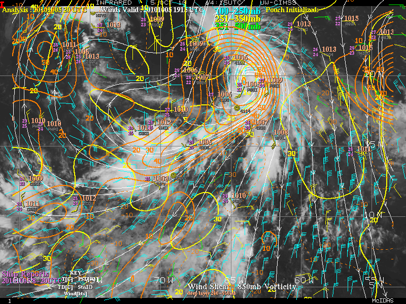
0 likes
Visit the Caribbean-Central America Weather Thread where you can find at first post web cams,radars
and observations from Caribbean basin members Click Here
and observations from Caribbean basin members Click Here
-
HURAKAN

- Professional-Met

- Posts: 46084
- Age: 39
- Joined: Thu May 20, 2004 4:34 pm
- Location: Key West, FL
- Contact:
What is funny is that something is about to form (climatology) and computer models will get some credit or most of the credit. But if you think about it, they have been forecasting the development of this system for a long time now and so far, nothing to write home about.
Back to lurker mode!!!
Back to lurker mode!!!
0 likes
-
srainhoutx

- S2K Supporter
- Posts: 6919
- Age: 68
- Joined: Sun Jan 14, 2007 11:34 am
- Location: Haywood County, NC
- Contact:
Re: Waves 30L/ 31L in Eastern Atlantic
I would love to see an image a bit further E. 
0 likes
Carla/Alicia/Jerry(In The Eye)/Michelle/Charley/Ivan/Dennis/Katrina/Rita/Wilma/Ike/Harvey
Member: National Weather Association
Wx Infinity Forums
http://wxinfinity.com/index.php
Facebook.com/WeatherInfinity
Twitter @WeatherInfinity
Member: National Weather Association
Wx Infinity Forums
http://wxinfinity.com/index.php
Facebook.com/WeatherInfinity
Twitter @WeatherInfinity
Who is online
Users browsing this forum: Kennethb and 201 guests