Disturbed weather in Eastern Atlantic (Is invest 95L)
Moderator: S2k Moderators
Forum rules
The posts in this forum are NOT official forecasts and should not be used as such. They are just the opinion of the poster and may or may not be backed by sound meteorological data. They are NOT endorsed by any professional institution or STORM2K. For official information, please refer to products from the National Hurricane Center and National Weather Service.
- cycloneye
- Admin

- Posts: 149585
- Age: 69
- Joined: Thu Oct 10, 2002 10:54 am
- Location: San Juan, Puerto Rico
Re: Waves 30L/ 31L in Eastern Atlantic
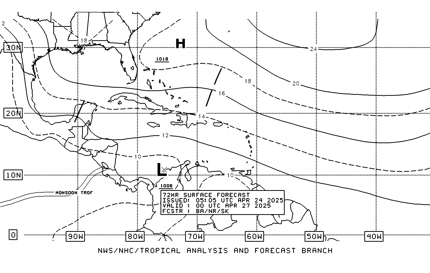
TAFB 72 hour forecast. Has low moving westward.


0 likes
Visit the Caribbean-Central America Weather Thread where you can find at first post web cams,radars
and observations from Caribbean basin members Click Here
and observations from Caribbean basin members Click Here
- MiamiHurricanes10
- S2K Supporter

- Posts: 260
- Joined: Mon Jul 19, 2010 7:56 pm
- Location: Miami, Florida
Re: Waves 30L/ 31L in Eastern Atlantic
NHC/TAFB Experimental Gridded Marine Forecasts Valid August 24, 2010 -- 18:00 GMT. WIND (KT).


0 likes
Moving NW according to the NHC, actually looks a little too far east for my liking, I bet we may see a little bit of a westward adjustment but somewhere close to 60W looks a good call right now...
The troughing will probably recurve all CV systems this year, its VERY impressive...
The troughing will probably recurve all CV systems this year, its VERY impressive...
0 likes
Personal Forecast Disclaimer:
The posts in this forum are NOT official forecast and should not be used as such. They are just the opinion of the poster and may or may not be backed by sound meteorological data. They are NOT endorsed by any professional institution or storm2k.org. For official information, please refer to the NHC and NWS products
The posts in this forum are NOT official forecast and should not be used as such. They are just the opinion of the poster and may or may not be backed by sound meteorological data. They are NOT endorsed by any professional institution or storm2k.org. For official information, please refer to the NHC and NWS products
- MiamiHurricanes10
- S2K Supporter

- Posts: 260
- Joined: Mon Jul 19, 2010 7:56 pm
- Location: Miami, Florida
Re:
KWT wrote:Moving NW according to the NHC, actually looks a little too far east for my liking, I bet we may see a little bit of a westward adjustment but somewhere close to 60W looks a good call right now...
The troughing will probably recurve all CV systems this year, its VERY impressive...
Um, no. You're still ignoring the fact of the deeply negative NAO we are heading into. If this system does recurve, the next one likely won't.
0 likes
- MiamiHurricanes10
- S2K Supporter

- Posts: 260
- Joined: Mon Jul 19, 2010 7:56 pm
- Location: Miami, Florida
Re: Re:
MiamiHurricanes10 wrote:KWT wrote:Moving NW according to the NHC, actually looks a little too far east for my liking, I bet we may see a little bit of a westward adjustment but somewhere close to 60W looks a good call right now...
The troughing will probably recurve all CV systems this year, its VERY impressive...
Um, no. You're still ignoring the fact of the deeply negative NAO we are heading into. If this system does recurve, the next one likely won't.
Oh, I forgot about the location of the 500mb height anomaly. To give you an idea, it looks very, very similar to 2005...located over the NE, around New York state.
0 likes
Re: Re:
MiamiHurricanes10 wrote:KWT wrote:Moving NW according to the NHC, actually looks a little too far east for my liking, I bet we may see a little bit of a westward adjustment but somewhere close to 60W looks a good call right now...
The troughing will probably recurve all CV systems this year, its VERY impressive...
Um, no. You're still ignoring the fact of the deeply negative NAO we are heading into. If this system does recurve, the next one likely won't.
You do know a -ve NAO promotes LOW pressure over the subtropics right?
Thats why the troughing has been digging down like it has, because we've had a -ve NAO which has meant the jet has been diving southwards over the E.US/W.Atlantic and also sadly for me, right over W.Europe. Inbetween is a decent ridge hence why this heads west till 40-45W but once past that troughing becomes dominant.
0 likes
Personal Forecast Disclaimer:
The posts in this forum are NOT official forecast and should not be used as such. They are just the opinion of the poster and may or may not be backed by sound meteorological data. They are NOT endorsed by any professional institution or storm2k.org. For official information, please refer to the NHC and NWS products
The posts in this forum are NOT official forecast and should not be used as such. They are just the opinion of the poster and may or may not be backed by sound meteorological data. They are NOT endorsed by any professional institution or storm2k.org. For official information, please refer to the NHC and NWS products
- cycloneye
- Admin

- Posts: 149585
- Age: 69
- Joined: Thu Oct 10, 2002 10:54 am
- Location: San Juan, Puerto Rico
Re: Large area of disturbed weather in Eastern Atlantic
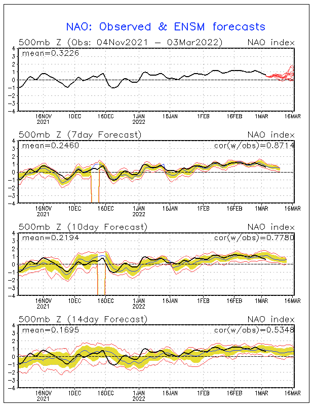
The negative NAO is forecast to stay thru the end of August/early September.

0 likes
Visit the Caribbean-Central America Weather Thread where you can find at first post web cams,radars
and observations from Caribbean basin members Click Here
and observations from Caribbean basin members Click Here
Ah well lets just enjoy a system that stays away from land.
I personally think this one could well become a major by the way...so may well become the strongest of the season yet, not that that is difficult mind you!
I personally think this one could well become a major by the way...so may well become the strongest of the season yet, not that that is difficult mind you!
0 likes
Personal Forecast Disclaimer:
The posts in this forum are NOT official forecast and should not be used as such. They are just the opinion of the poster and may or may not be backed by sound meteorological data. They are NOT endorsed by any professional institution or storm2k.org. For official information, please refer to the NHC and NWS products
The posts in this forum are NOT official forecast and should not be used as such. They are just the opinion of the poster and may or may not be backed by sound meteorological data. They are NOT endorsed by any professional institution or storm2k.org. For official information, please refer to the NHC and NWS products
- Blown Away
- S2K Supporter

- Posts: 10253
- Joined: Wed May 26, 2004 6:17 am
Re: Re:
KWT wrote:MiamiHurricanes10 wrote:KWT wrote:Moving NW according to the NHC, actually looks a little too far east for my liking, I bet we may see a little bit of a westward adjustment but somewhere close to 60W looks a good call right now...
The troughing will probably recurve all CV systems this year, its VERY impressive...
Um, no. You're still ignoring the fact of the deeply negative NAO we are heading into. If this system does recurve, the next one likely won't.
You do know a -ve NAO promotes LOW pressure over the subtropics right?
Thats why the troughing has been digging down like it has, because we've had a -ve NAO which has meant the jet has been diving southwards over the E.US/W.Atlantic and also sadly for me, right over W.Europe. Inbetween is a decent ridge hence why this heads west till 40-45W but once past that troughing becomes dominant.
The -NAO has been predicted for months and I kept asking how can JB and others be calling for so many landfalls?? Then it was La Nina was going to push tracks farther south? I just don't get it, -NAO to me means weak ridging and farther east recurves??
0 likes
Hurricane Eye Experience: David 79, Irene 99, Frances 04, Jeanne 04, Wilma 05… Hurricane Brush Experience: Andrew 92, Erin 95, Floyd 99, Matthew 16, Irma 17, Ian 22, Nicole 22…
-
hurricaneCW
- Category 5

- Posts: 1799
- Joined: Wed Mar 03, 2010 6:20 am
- Location: Toms River, NJ
Re: Large area of disturbed weather in Eastern Atlantic
This season is its own anomaly. I too thought that a moderate to strong la nina meant stronger Atlantic ridging and thus giving us a pattern similar to 2007. I don't think all Cape Verde storms will recurve this year. The long range gfs builds a nice subtropical high stretching across the Atlantic. So while this one is a guaranteed recurve, future systems are very uncertain.
0 likes
Re: Large area of disturbed weather in Eastern Atlantic
What do you mean, if it's recurving before USA , it will be a fish, but if it crosses the lesser antilles, before recurving it will not be a fish for the islands?
0 likes
- Blown Away
- S2K Supporter

- Posts: 10253
- Joined: Wed May 26, 2004 6:17 am
Re: Large area of disturbed weather in Eastern Atlantic
OURAGAN wrote:What do you mean, if it's recurving before USA , it will be a fish, but if it crosses the lesser antilles, before recurving it will not be a fish for the islands?
Please don't start this again, almost all storms recurve at some point and we all know it's not a fish if it hits land!
0 likes
Hurricane Eye Experience: David 79, Irene 99, Frances 04, Jeanne 04, Wilma 05… Hurricane Brush Experience: Andrew 92, Erin 95, Floyd 99, Matthew 16, Irma 17, Ian 22, Nicole 22…
-
Aric Dunn
- Category 5

- Posts: 21238
- Age: 43
- Joined: Sun Sep 19, 2004 9:58 pm
- Location: Ready for the Chase.
- Contact:
Re: Waves 30L/ 31L in Eastern Atlantic
cycloneye wrote:The yellow circle includes from PGI-31L to PGI-33L.
that was expected.. because it wont be anyone particular wave that develops their identities are nearly lost at this point.
0 likes
Note: If I make a post that is brief. Please refer back to previous posts for the analysis or reasoning. I do not re-write/qoute what my initial post said each time.
If there is nothing before... then just ask
Space & Atmospheric Physicist, Embry-Riddle Aeronautical University,
I believe the sky is falling...
If there is nothing before... then just ask
Space & Atmospheric Physicist, Embry-Riddle Aeronautical University,
I believe the sky is falling...
Re: Waves 30L/ 31L in Eastern Atlantic
MiamiHurricanes10 wrote:Interesting 12z CMC. Develops PGI31L and shoots it northward. Then, when it meets the subtropical ridge it heads west. Towards the end of the run it begins WNW motion.
http://moe.met.fsu.edu/cgi-bin/cmctc2.cgi?time=2010081912&field=Sea%20Level%20Pressure&hour=Animation
That pattern in the CMC looks essentially blocked - upper air pattern stagnant at the end of the run.
0 likes
- wxman57
- Moderator-Pro Met

- Posts: 23175
- Age: 68
- Joined: Sat Jun 21, 2003 8:06 pm
- Location: Houston, TX (southwest)
Re: Re:
Blown Away wrote:
The -NAO has been predicted for months and I kept asking how can JB and others be calling for so many landfalls?? Then it was La Nina was going to push tracks farther south? I just don't get it, -NAO to me means weak ridging and farther east recurves??
Given the current and projected -NAO, CV storms are less likely to be a U.S. threat. It's the closer-in development in the Caribbean and SW Atlantic that would be the threat to the U.S. Anything forming by the CV islands will have a hard time making it west to the U.S.
0 likes
- ColinDelia
- S2K Supporter

- Posts: 918
- Joined: Mon Aug 29, 2005 5:52 am
- Location: The Beach, FL
Here's one paper on the NAO Index/recurvature debate.
http://ams.confex.com/ams/pdfpapers/37310.pdf
For the 10 highest NAO index years the average longitude of re-curvature was 83.4
For the 10 lowest NAO index years the average longitude of re-curvature was 61.8
(EDIT NOTE: This is incorrect and I read the table in the paper incorrectly but don't want to change it or else Ronjon's post below won't make sense.
The correct info is 10 highest NAO years LOR=71.2, 10 lowest NAO years LOR=70.9. No significant difference)
The data included only storms that reached hurricane strength and formed South of 23.5N and East of 65W
Not saying it's definitive but a good first read for me anyway
Last edited by ColinDelia on Thu Aug 19, 2010 2:57 pm, edited 1 time in total.
0 likes
- Comanche
- Category 1

- Posts: 381
- Age: 54
- Joined: Wed Jul 06, 2005 9:33 am
- Location: Clear Lake City Texas
Re: Re:
The -NAO has been predicted for months and I kept asking how can JB and others be calling for so many landfalls?? Then it was La Nina was going to push tracks farther south? I just don't get it, -NAO to me means weak ridging and farther east recurves??
Long-term seasonal TC forecasting is about the same as the horse races. I wish these services would stop already with the numbers prediction game, it is retarded at best. It would be of much better service to just say things like "expectations are for a more active than normal season based on the effects of La Nina and heat content". I mean really, duh, I predict 16 named storms, 10 hurricanes, 4 majors, 3 strong GOM systems, 2 majors hitting the conus, yada yada yada. That is useless dart throwing in hopes someones forecast is on the money and they can have bragging rights and be able to sell their forecasting services. The intra-season updates could talk about the dominant pattern set-up such as prevailing steering currents and where storms are likely to be steered based on the origin, versus people just updating their number forecasts. It's like the Federal Reserve predicting GDP for next year when they cannot even get it right in the current quarters. It's of service to nobody.
0 likes
-
hurricaneCW
- Category 5

- Posts: 1799
- Joined: Wed Mar 03, 2010 6:20 am
- Location: Toms River, NJ
Re: Large area of disturbed weather in Eastern Atlantic
Home brew is going to be the way to go this season if you want to see landfalls unless one Cape Verde storm decides to sneak through under the trough. October will probably be the best month for landfalls.
0 likes
Re: Re:
wxman57 wrote:Blown Away wrote:
The -NAO has been predicted for months and I kept asking how can JB and others be calling for so many landfalls?? Then it was La Nina was going to push tracks farther south? I just don't get it, -NAO to me means weak ridging and farther east recurves??
Given the current and projected -NAO, CV storms are less likely to be a U.S. threat. It's the closer-in development in the Caribbean and SW Atlantic that would be the threat to the U.S. Anything forming by the CV islands will have a hard time making it west to the U.S.
How far do NAO forecasts go out? Forgive this elementary question, but I would enjoy reading about it.
0 likes
Who is online
Users browsing this forum: No registered users and 269 guests


