Disturbed weather in Eastern Atlantic (Is invest 95L)
Moderator: S2k Moderators
Forum rules

The posts in this forum are NOT official forecasts and should not be used as such. They are just the opinion of the poster and may or may not be backed by sound meteorological data. They are NOT endorsed by any professional institution or STORM2K. For official information, please refer to products from the National Hurricane Center and National Weather Service.
-
wxman57

- Moderator-Pro Met

- Posts: 23175
- Age: 68
- Joined: Sat Jun 21, 2003 8:06 pm
- Location: Houston, TX (southwest)
Re: Large area of disturbed weather in Eastern Atlantic
Yes, moderate westerly winds are blowing across the east Atlantic from west of 40W all the way to Africa. They're not directly related to one particular LLC presently. The whole mess needs to consolidate for development to occur. Will take a couple of days.
0 likes
-
cycloneye

- Admin

- Posts: 149585
- Age: 69
- Joined: Thu Oct 10, 2002 10:54 am
- Location: San Juan, Puerto Rico
Re: Large area of disturbed weather in Eastern Atlantic
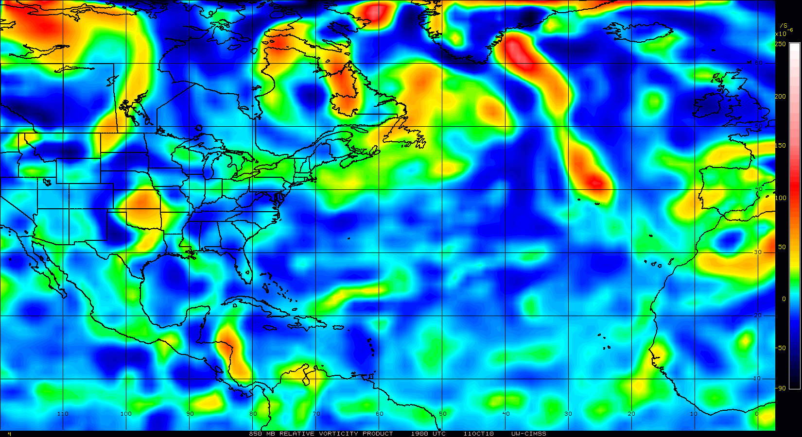
850mb vorticty continues to increase.
0 likes
Visit the Caribbean-Central America Weather Thread where you can find at first post web cams,radars
and observations from Caribbean basin members Click Here
and observations from Caribbean basin members Click Here
-
MiamiHurricanes10

- S2K Supporter

- Posts: 260
- Joined: Mon Jul 19, 2010 7:56 pm
- Location: Miami, Florida
Re: Large area of disturbed weather in Eastern Atlantic
00z surface analysis indicates that PGI31L has developed an area of low pressure. This low pressure area can be clearly seen on satellite imagery, the ASCAT image Ivan posted shows it very well too.

0 likes
-
Vortmax1
- Category 1

- Posts: 360
- Joined: Wed Jul 07, 2010 11:35 pm
- Location: Port Salerno, FL
- Contact:
Too much ITCZ involved here now.
TROPICAL WEATHER DISCUSSION
NWS TPC/NATIONAL HURRICANE CENTER MIAMI FL
805 PM EDT THU AUG 19 2010
...ITCZ...
ITCZ AXIS IS CENTERED ALONG 13N38W 11N47W 13N55W. EAST OF THE
TROPICAL WAVE BETWEEN 33W-38W...A MONSOONAL TROUGH IS ANALYZED
AS A SURFACE TROUGH IN PLACE OF THE ITCZ FROM EASTERN MAURITANIA
NEAR 19N06W TO THE W AFRICA COAST NEAR 14N17W AND INTO THE E
ATLC TO 13N27W. THIS MONSOONAL TROUGH HAS PERSISTED OVER THE
PAST FEW DAYS WITH WESTERLY LOW-LEVEL FLOW OBSERVED S OF 13N. AN
EARLIER MORNING ASCAT PASS AROUND 19/1054 UTC INDICATED THE
BEGINNINGS OF A BROAD LOW-LEVEL CIRCULATION SW OF THE CAPE VERDE
ISLANDS NEAR 13N26W. SCATTERED MODERATE AND ISOLATED STRONG
CONVECTION REMAINS UNORGANIZED AND FOCUSED IN THE VICINITY OF
THIS MONSOONAL TROUGH FROM 08N-14N BETWEEN 16W-30W. ELSEWHERE...
SCATTERED MODERATE CONVECTION IS S OF THE ITCZ AXIS FROM 04N-11N
BETWEEN 30W-39W.
0 likes
Re:
Vortmax1 wrote:Too much ITCZ involved here now.
As you posted in the NHC discussion, not the ITCZ but a monsoon trough; similar but not quite the same thing. Also seen on their surface map, where the ITCZ is shown as a hatched line west of 40W and the monsoon trough as the dashed line near the Cape Verde Is. Agree with you that the area of cyclonic turning is too broad currently.
0 likes
-
ConvergenceZone
.gif)
- Category 5

- Posts: 5241
- Joined: Fri Jul 29, 2005 1:40 am
- Location: Northern California
-
Aric Dunn
- Category 5
- Posts: 21238
- Age: 43
- Joined: Sun Sep 19, 2004 9:58 pm
- Location: Ready for the Chase.
- Contact:
Re: Re:
supercane wrote:Vortmax1 wrote:Too much ITCZ involved here now.
As you posted in the NHC discussion, not the ITCZ but a monsoon trough; similar but not quite the same thing. Also seen on their surface map, where the ITCZ is shown as a hatched line west of 40W and the monsoon trough as the dashed line near the Cape Verde Is. Agree with you that the area of cyclonic turning is too broad currently.
both a trough and the ITCZ are boundaries and are linear convergence lines which inhibit inflow in whatever quadrants they happen to be located when a TC is trying to develop.
0 likes
Note: If I make a post that is brief. Please refer back to previous posts for the analysis or reasoning. I do not re-write/qoute what my initial post said each time.
If there is nothing before... then just ask
Space & Atmospheric Physicist, Embry-Riddle Aeronautical University,
I believe the sky is falling...
If there is nothing before... then just ask
Space & Atmospheric Physicist, Embry-Riddle Aeronautical University,
I believe the sky is falling...
-
Aric Dunn
- Category 5
- Posts: 21238
- Age: 43
- Joined: Sun Sep 19, 2004 9:58 pm
- Location: Ready for the Chase.
- Contact:
Re:
Vortmax1 wrote:sure... no... probably more like 3 days till we have a depression...
Sure...Yep...that's what I was thinking.
lol.. I originally said a solid 2 days.. which meant at least two days.. lol
0 likes
Note: If I make a post that is brief. Please refer back to previous posts for the analysis or reasoning. I do not re-write/qoute what my initial post said each time.
If there is nothing before... then just ask
Space & Atmospheric Physicist, Embry-Riddle Aeronautical University,
I believe the sky is falling...
If there is nothing before... then just ask
Space & Atmospheric Physicist, Embry-Riddle Aeronautical University,
I believe the sky is falling...
-
Typhoon_Willie

- Category 5
- Posts: 1042
- Joined: Mon Jun 09, 2003 3:19 pm
- Location: Greenacres City, Florida
Re: Large area of disturbed weather in Eastern Atlantic
Looks like 3 days might be a good bet.
0 likes
Re: Re:
Aric Dunn wrote:both a trough and the ITCZ are boundaries and are linear convergence lines which inhibit inflow in whatever quadrants they happen to be located when a TC is trying to develop.
The definitions of the terms trough, ITCZ, and monsoon trough share similarities, but they are not synonymous. Trough is the more general term. Definition of trough from AMS glossary:
trough—In meteorology, an elongated area of relatively low atmospheric pressure; the opposite of a ridge.
The definition of the ITCZ is more restrictive. ITCZ definition from AMS glossary:
intertropical convergence zone—1. (Also called ITCZ, equatorial convergence zone.) The axis, or a portion thereof, of the broad trade-wind current of the Tropics.
This axis is the dividing line between the southeast trades and the northeast trades (of the Southern and Northern Hemispheres, respectively).
Compare with this description of monsoon trough from The Asian monsoon By Bin Wang,p.154:
The monsoon trough is characterized by the great horizontal wind shear, with the westerlies or south-westerly winds to the south and easterly trade winds to the north.
The difference in definitions lead to a different interpretation of the westerly winds seen associated with this broad area of low pressure; they are not indicative of a single LLCC but are an expected feature of the monsoon trough that results in a broad cyclonic flow. Also storms can form in the monsoon trough and actually lift the trough poleward.
0 likes
-
TwisterFanatic

- Category 5
- Posts: 1041
- Joined: Mon Jun 28, 2010 12:43 pm
- Location: Sallisaw, Oklahoma
Re: Large area of disturbed weather in Eastern Atlantic
Recurve on GFS again.
0 likes
Personal Forecast Disclaimer:
The posts in this forum are NOT official forecast and should not be used as such. They are just the opinion of the poster and may or may not be backed by sound meteorological data. They are NOT endorsed by any professional institution or storm2k.org. For official information, please refer to the NHC and NWS products.
The posts in this forum are NOT official forecast and should not be used as such. They are just the opinion of the poster and may or may not be backed by sound meteorological data. They are NOT endorsed by any professional institution or storm2k.org. For official information, please refer to the NHC and NWS products.


-
dwsqos2
Re: Large area of disturbed weather in Eastern Atlantic
It's a broad mess in a sounding desert. The genesis date seems to keep moving forward. This is just paranoia, but I wonder if this even develops.
0 likes
Who is online
Users browsing this forum: No registered users and 229 guests