ATL: Ex-Hurricane DANIELLE - Discussion
Moderator: S2k Moderators
-
hurricaneCW
- Category 5

- Posts: 1799
- Joined: Wed Mar 03, 2010 6:20 am
- Location: Toms River, NJ
Re: ATL : INVEST 95L - DISCUSSION
If that trough is as deep as the gfs says it will be, then we shouldn't be getting near seasonable temperatures in the low 80s up here. It should be quite a few degrees below normal but that's not what the forecast shows. I definitely think the trough is way overdone, it's too early for such as powerful trough to develop, in late September yes, in late August, no.
0 likes
-
gatorcane

- S2K Supporter

- Posts: 23708
- Age: 48
- Joined: Sun Mar 13, 2005 3:54 pm
- Location: Boca Raton, FL
Re: ATL : INVEST 95L - DISCUSSION
hurricaneCW wrote:If that trough is as deep as the gfs says it will be, then we shouldn't be getting near seasonable temperatures in the low 80s up here. It should be quite a few degrees below normal but that's not what the forecast shows. I definitely think the trough is way overdone, it's too early for such as powerful trough to develop, in late September yes, in late August, no.
It's very possible, around August 13th.....2004, what a trough that came down and gave parts of Northern FL lows in the low to mid 60s....of course it pushed Charley into SW Florida.
I actually think we will see a deep trough given the globals are all showing it to some extent. Perhaps the GFS is a bit aggressive on it. I think the Euro has it right.
0 likes
-
hurricaneCW
- Category 5
- Posts: 1799
- Joined: Wed Mar 03, 2010 6:20 am
- Location: Toms River, NJ
Re: ATL : INVEST 95L - DISCUSSION
gatorcane wrote:hurricaneCW wrote:If that trough is as deep as the gfs says it will be, then we shouldn't be getting near seasonable temperatures in the low 80s up here. It should be quite a few degrees below normal but that's not what the forecast shows. I definitely think the trough is way overdone, it's too early for such as powerful trough to develop, in late September yes, in late August, no.
It's very possible, around August 13th.....2004, what a trough that came down and gave parts of Northern FL lows in the low to mid 60s....of course it pushed Charley into SW Florida.
It's very rare though at this time of the year, the trough that scooped Charley up was incredibly rare. I know that it's possible but a trough that strong is highly unlikely. Although I'm not discounting it because of the -NAO and +PNA do yield a trough in the east. Long range models flatten the -NAO and +PNA thus the increased ridging in the Atlantic.
0 likes

Yeah its quite a strong signal for a east coast trough...I just can't see why people seem to be almost dismissing it like its going to be downgraded...the first trough is now just 72hrs out and there has been no change and total agreement on its strength and how it starts to act upon 95L at 96hrs...the further east this stays the further east it probably recurves I suspect in this pattern.
The real question is how strong it gets, I see no reason for this not to go upto say 125-135mph.
The real question is how strong it gets, I see no reason for this not to go upto say 125-135mph.
0 likes
Personal Forecast Disclaimer:
The posts in this forum are NOT official forecast and should not be used as such. They are just the opinion of the poster and may or may not be backed by sound meteorological data. They are NOT endorsed by any professional institution or storm2k.org. For official information, please refer to the NHC and NWS products
The posts in this forum are NOT official forecast and should not be used as such. They are just the opinion of the poster and may or may not be backed by sound meteorological data. They are NOT endorsed by any professional institution or storm2k.org. For official information, please refer to the NHC and NWS products
-
wxman57

- Moderator-Pro Met

- Posts: 23175
- Age: 68
- Joined: Sat Jun 21, 2003 8:06 pm
- Location: Houston, TX (southwest)
Re: ATL : INVEST 95L - DISCUSSION
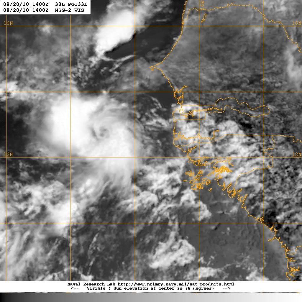
Kind of looks like an eye forming on the rotation east of the invest:

0 likes
-
hurricaneCW
- Category 5
- Posts: 1799
- Joined: Wed Mar 03, 2010 6:20 am
- Location: Toms River, NJ
Re:
KWT wrote:Yeah its quite a strong signal for a east coast trough...I just can't see why people seem to be almost dismissing it like its going to be downgraded...the first trough is now just 72hrs out and there has been no change and total agreement on its strength and how it starts to act upon 95L at 96hrs...the further east this stays the further east it probably recurves I suspect in this pattern.
The real question is how strong it gets, I see no reason for this not to go upto say 125-135mph.
I say Cat 5, 170mph.
0 likes
-
tolakram
- Admin

- Posts: 20186
- Age: 62
- Joined: Sun Aug 27, 2006 8:23 pm
- Location: Florence, KY (name is Mark)
Re: ATL : INVEST 95L - DISCUSSION
You mean ... eye like feature. 
0 likes
M a r k
- - - - -
Join us in chat: Storm2K Chatroom Invite. Android and IOS apps also available.
The posts in this forum are NOT official forecasts and should not be used as such. Posts are NOT endorsed by any professional institution or STORM2K.org. For official information and forecasts, please refer to NHC and NWS products.
Re: ATL : INVEST 95L - DISCUSSION
Looks like two LLC's out there - Dr. Knabb's "cone" graphic was adjusted during the morning to show a pretty strong trough west of 50W (based on the 12Z models)...
0 likes
-
somethingfunny

- ChatStaff

- Posts: 3926
- Age: 37
- Joined: Thu May 31, 2007 10:30 pm
- Location: McKinney, Texas
Re: ATL : INVEST 95L - DISCUSSION
I say it peaks as a Category Two. My reasoning is unscientific - the past two Danielles in 04 and 98 were both out-to-sea Cat2 storms.
0 likes
I am not a meteorologist, and any posts made by me are not official forecasts or to be interpreted as being intelligent. These posts are just my opinions and are probably silly opinions.
I tell ya what though wxman57 that feature is beginning to become real interesting its got a good circulation on it and its tight.
Puts the invest they are watching to total shame, that maybe the one to watch!
Puts the invest they are watching to total shame, that maybe the one to watch!
0 likes
Personal Forecast Disclaimer:
The posts in this forum are NOT official forecast and should not be used as such. They are just the opinion of the poster and may or may not be backed by sound meteorological data. They are NOT endorsed by any professional institution or storm2k.org. For official information, please refer to the NHC and NWS products
The posts in this forum are NOT official forecast and should not be used as such. They are just the opinion of the poster and may or may not be backed by sound meteorological data. They are NOT endorsed by any professional institution or storm2k.org. For official information, please refer to the NHC and NWS products
-
wxman57
- Moderator-Pro Met
- Posts: 23175
- Age: 68
- Joined: Sat Jun 21, 2003 8:06 pm
- Location: Houston, TX (southwest)
Re: ATL : INVEST 95L - DISCUSSION
tolakram wrote:You mean ... eye like feature.
Yeah, eye-like feature. Not a true eye, I'm sure. Wonder what it would be called if it was in the central Gulf of Mexico? It's about twice the size of 2008's Marco.
0 likes
-
srainhoutx

- S2K Supporter
- Posts: 6919
- Age: 68
- Joined: Sun Jan 14, 2007 11:34 am
- Location: Haywood County, NC
- Contact:
Re: ATL : INVEST 95L - DISCUSSION
Interesting to say the least wxman57...
0 likes
Carla/Alicia/Jerry(In The Eye)/Michelle/Charley/Ivan/Dennis/Katrina/Rita/Wilma/Ike/Harvey
Member: National Weather Association
Wx Infinity Forums
http://wxinfinity.com/index.php
Facebook.com/WeatherInfinity
Twitter @WeatherInfinity
Member: National Weather Association
Wx Infinity Forums
http://wxinfinity.com/index.php
Facebook.com/WeatherInfinity
Twitter @WeatherInfinity
-
hurricaneCW
- Category 5
- Posts: 1799
- Joined: Wed Mar 03, 2010 6:20 am
- Location: Toms River, NJ
Re: ATL : INVEST 95L - DISCUSSION
It looks like a TD at least, it probably would be if it was in the gulf. Very impressive little entity. I assume it will get shredded by 95L's much larger circulation.
0 likes
Re: Re:
hurricaneCW wrote: I say Cat 5, 170mph.
Wow that'd be pretty amazing, there are a couple of recurvers that have become that strong, Cleo was estimated to become a cat-5 in 1958 though I think recon was not using the correct Extrap for the surface-flight level winds...so the 160mph winds were probably overdone and probably down closer to say 145mph, still a strong hurricane for sure though.
I certainly wouldn't be shocked to see a category-4 come from this but it depends on exactly how far west it does get really.
0 likes
Personal Forecast Disclaimer:
The posts in this forum are NOT official forecast and should not be used as such. They are just the opinion of the poster and may or may not be backed by sound meteorological data. They are NOT endorsed by any professional institution or storm2k.org. For official information, please refer to the NHC and NWS products
The posts in this forum are NOT official forecast and should not be used as such. They are just the opinion of the poster and may or may not be backed by sound meteorological data. They are NOT endorsed by any professional institution or storm2k.org. For official information, please refer to the NHC and NWS products
Re: ATL : INVEST 95L - DISCUSSION
wxman57 wrote:tolakram wrote:You mean ... eye like feature.
Yeah, eye-like feature. Not a true eye, I'm sure. Wonder what it would be called if it was in the central Gulf of Mexico? It's about twice the size of 2008's Marco.
Whilst I agree I've gotta admit, the way the low level clouds wrap the whole round is pretty interesting, it looks pretty defined but probably just a visual illusion
0 likes
Personal Forecast Disclaimer:
The posts in this forum are NOT official forecast and should not be used as such. They are just the opinion of the poster and may or may not be backed by sound meteorological data. They are NOT endorsed by any professional institution or storm2k.org. For official information, please refer to the NHC and NWS products
The posts in this forum are NOT official forecast and should not be used as such. They are just the opinion of the poster and may or may not be backed by sound meteorological data. They are NOT endorsed by any professional institution or storm2k.org. For official information, please refer to the NHC and NWS products
Yes, I see an eye-like feature, too, though as we know rapidly developing systems often mean a very early recurve...
http://en.wikipedia.org/wiki/1980_Atlan ... ne_Frances
Frank
http://en.wikipedia.org/wiki/1980_Atlan ... ne_Frances
Frank
0 likes
Its not the system the models are suggesting Frank, its a totally other system.
I'd assume that whatever that is will rotate around the broad low that is further west and possibly slam into the CV islands, well probably not slam but give them something.
Probably a decent MCV that has formed over water and those sometimes do develop, though not sure there have been many over in that part of the basin...
ps, someone posted the microwave imagery on easternuswx....and...it actually is probably a low level circulation that is pulling convection around itself, possibly would match the critera for at least a depression if not a small TS...
0 likes
Personal Forecast Disclaimer:
The posts in this forum are NOT official forecast and should not be used as such. They are just the opinion of the poster and may or may not be backed by sound meteorological data. They are NOT endorsed by any professional institution or storm2k.org. For official information, please refer to the NHC and NWS products
The posts in this forum are NOT official forecast and should not be used as such. They are just the opinion of the poster and may or may not be backed by sound meteorological data. They are NOT endorsed by any professional institution or storm2k.org. For official information, please refer to the NHC and NWS products
-
Parungo
- Tropical Low

- Posts: 20
- Age: 54
- Joined: Sun Jul 26, 2009 8:12 am
- Location: Seville, Spain
- Contact:
Re: ATL : INVEST 95L - DISCUSSION
wxman57 wrote:Kind of looks like an eye forming on the rotation east of the invest:
Loop:

0 likes
-
hurricaneCW
- Category 5
- Posts: 1799
- Joined: Wed Mar 03, 2010 6:20 am
- Location: Toms River, NJ
Re: ATL : INVEST 95L - DISCUSSION
Nice wave in west-central Africa on that loop. I wonder if that would become something in the future.
0 likes
That system could well make this evolution more complicated because whilst I'd still favour a large cyclonic gyre over a small system that looks to have a tight closed LLC...but for sure its another factor to keep an eye on...maybe it gets 96L soon?
0 likes
Personal Forecast Disclaimer:
The posts in this forum are NOT official forecast and should not be used as such. They are just the opinion of the poster and may or may not be backed by sound meteorological data. They are NOT endorsed by any professional institution or storm2k.org. For official information, please refer to the NHC and NWS products
The posts in this forum are NOT official forecast and should not be used as such. They are just the opinion of the poster and may or may not be backed by sound meteorological data. They are NOT endorsed by any professional institution or storm2k.org. For official information, please refer to the NHC and NWS products
Who is online
Users browsing this forum: No registered users and 43 guests