Thanks, KWT - it's been crazy for me this morning and haven't had the chance to look at things as closely as per usual, though I also did hear Dr. Knabb speak about that ginormous ULL that extends from south of Bermuda to south of Puerto Rico (now that's a ULL) and said that at least for now is completely blocking anything from moving this way...
http://www.goes.noaa.gov/HURRLOOPS/huwvloop.html
ATL: Ex-Hurricane DANIELLE - Discussion
Moderator: S2k Moderators
-
CrazyC83
- Professional-Met

- Posts: 34315
- Joined: Tue Mar 07, 2006 11:57 pm
- Location: Deep South, for the first time!
Too bad there is no Recon out of Cape Verde, I'd really be interested to see what they would find...
Last edited by CrazyC83 on Fri Aug 20, 2010 10:58 am, edited 1 time in total.
0 likes
-
ConvergenceZone
.gif)
- Category 5

- Posts: 5241
- Joined: Fri Jul 29, 2005 1:40 am
- Location: Northern California
Re: ATL : INVEST 95L - DISCUSSION
Frank2 wrote:Thanks, KWT - it's been crazy for me this morning and haven't had the chance to look at things as closely as per usual, though I also did hear Dr. Knabb speak about that ginormous ULL that extends from south of Bermuda to south of Puerto Rico (now that's a ULL) and said that at least for now is completely blocking anything from moving this way...
http://www.goes.noaa.gov/HURRLOOPS/huwvloop.html
We should enjoy it while we can Frank, because next month I doubt that we will be this lucky...Sooner or later the good luck is going to break and that's due to happen soon, but probably not untill early to mid September.
0 likes
-
floridasun78
- Category 5
- Posts: 3755
- Joined: Sun May 17, 2009 10:16 pm
- Location: miami fl
-
ColinDelia

- S2K Supporter

- Posts: 918
- Joined: Mon Aug 29, 2005 5:52 am
- Location: The Beach, FL
Re: ATL : INVEST 95L - DISCUSSION
The NCEP ensemble perturbation forecasts show nothing but recurves (or very close to all recurves, a few ambiguous)
http://www.emc.ncep.noaa.gov/gmb/tpm/em ... single.gif
Some info on these forecasts. Not sure what has changed but the basic idea is there
http://journals.ametsoc.org/doi/full/10 ... -0434(1997)012%3C0140:ASEOTN%3E2.0.CO;2
http://www.emc.ncep.noaa.gov/gmb/tpm/em ... single.gif
Some info on these forecasts. Not sure what has changed but the basic idea is there
http://journals.ametsoc.org/doi/full/10 ... -0434(1997)012%3C0140:ASEOTN%3E2.0.CO;2
Last edited by ColinDelia on Fri Aug 20, 2010 11:09 am, edited 1 time in total.
0 likes
ConvergenceZone,
Yes, I'm enjoying it, for sure (lol) - I'm keeping an eye out for early southward-flying ducks, too (nothing yet)...
Well, I'm sure the CSU folks are toasting each other, but it's a complicated weather pattern out there at this time (that strong low forecast to form off the NE US coast is unusual for this time of year), so we'll see...
http://weather.unisys.com/gfsx/loop/gfsx_500p_loop.html
0 likes

Re:
floridasun78 wrote:how can you say it fish this early?? you know models can chance from now untill it get 60w you all saying to other dont worry this 100% fish i hope you right because if get north pr east of bahamas i will say were is fish you all calling fish will dispear
I haven't seen one person here say not to worry or it's going to be a fish 100%.
0 likes
-
gatorcane

- S2K Supporter
- Posts: 23708
- Age: 48
- Joined: Sun Mar 13, 2005 3:54 pm
- Location: Boca Raton, FL
Re:
floridasun78 wrote:how can you say it fish this early?? you know models can chance from now untill it get 60w you all saying to other dont worry this 100% fish i hope you right because if get north pr east of bahamas i will say were is fish you all calling fish will dispear
Every model we have has to be wrong, which I don't think is likely as the recurve would happen about 6-7 days from now. Could future Danielle slow down and meander in the Central Atlantic for a bit before hitching a ride on a trough? Possibly but the threat to the islands and especially U.S is very low at this point. We can never be 100% but right now my confidence is about 90%.
Last edited by gatorcane on Fri Aug 20, 2010 11:14 am, edited 1 time in total.
0 likes

Re:
CrazyC83 wrote:One thing this does is clearly establishes where the center is - NRL had it way southwest of where the eye is at 12.7N 19.5W. A tropical storm watch at least may be needed for the southern Cape Verde islands unless this drifts back southwest.
Thats not 95L FWIW...thats a totally different and seperate system that emerged, I suspect 96L or possibly straight to TD is possible if it holds that presentation in the next 12hrs.
95L is the broad gyre to the SW of that little small MCV type feature....I wonder if that will develop, it certainly could be a risk to CV!
0 likes
Personal Forecast Disclaimer:
The posts in this forum are NOT official forecast and should not be used as such. They are just the opinion of the poster and may or may not be backed by sound meteorological data. They are NOT endorsed by any professional institution or storm2k.org. For official information, please refer to the NHC and NWS products
The posts in this forum are NOT official forecast and should not be used as such. They are just the opinion of the poster and may or may not be backed by sound meteorological data. They are NOT endorsed by any professional institution or storm2k.org. For official information, please refer to the NHC and NWS products
-
MiamiHurricanes10

- S2K Supporter
- Posts: 260
- Joined: Mon Jul 19, 2010 7:56 pm
- Location: Miami, Florida
Re: ATL : INVEST 95L - DISCUSSION
Very interesting that 95L is the monsoonal trough, so basically what we are seeing here is what you would usually see develop in the western Pacific. This system has very good potential, and as for me, I think this could very well become the first major hurricane of the season.
TPW says it all in this situation. Look at the rotation there, I wouldn't be surprised if this becomes a tropical depression by tomorrow.

TPW says it all in this situation. Look at the rotation there, I wouldn't be surprised if this becomes a tropical depression by tomorrow.
0 likes
Yeah I agree with that, I suspect the lower then normal pressures down there maybe allowing for a evolution more typical of the WPAC perhaps?
Looks to me like the broad low is slowly going to strengthen, the wildcard is the system to the east and what it does, probably will see some Fujiwara probably in the next 24-36hrs into the CV Islands IMO.
Looks to me like the broad low is slowly going to strengthen, the wildcard is the system to the east and what it does, probably will see some Fujiwara probably in the next 24-36hrs into the CV Islands IMO.
0 likes
Personal Forecast Disclaimer:
The posts in this forum are NOT official forecast and should not be used as such. They are just the opinion of the poster and may or may not be backed by sound meteorological data. They are NOT endorsed by any professional institution or storm2k.org. For official information, please refer to the NHC and NWS products
The posts in this forum are NOT official forecast and should not be used as such. They are just the opinion of the poster and may or may not be backed by sound meteorological data. They are NOT endorsed by any professional institution or storm2k.org. For official information, please refer to the NHC and NWS products

-
hurricaneCW
- Category 5
- Posts: 1799
- Joined: Wed Mar 03, 2010 6:20 am
- Location: Toms River, NJ
Re: ATL : INVEST 95L - DISCUSSION
Interesting scenario on the latest gfs. It kind of gets stuck near 40N by 288 hrs. Prior to that, the storm almost gets caught under the high at a much lower latitude. We'll see if this leads to something new in the future.
0 likes
-
MiamiHurricanes10
- S2K Supporter
- Posts: 260
- Joined: Mon Jul 19, 2010 7:56 pm
- Location: Miami, Florida
Re: ATL : INVEST 95L - DISCUSSION
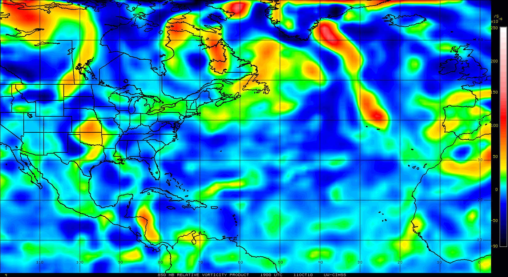
850mb vorticity continues to increase in association with 95L. IMO, this should be raised to red (60%) at 2p.m EDT.
0 likes
Yeah esp if it got a little bit further west then progged!
These broad almost monsoonal systems usually do take a good couple of days to pull themself together so probably will take a little yet, esp given its in the E.Atlantic and the NHC are never too keen on systems in this part of the basin.
These broad almost monsoonal systems usually do take a good couple of days to pull themself together so probably will take a little yet, esp given its in the E.Atlantic and the NHC are never too keen on systems in this part of the basin.
0 likes
Personal Forecast Disclaimer:
The posts in this forum are NOT official forecast and should not be used as such. They are just the opinion of the poster and may or may not be backed by sound meteorological data. They are NOT endorsed by any professional institution or storm2k.org. For official information, please refer to the NHC and NWS products
The posts in this forum are NOT official forecast and should not be used as such. They are just the opinion of the poster and may or may not be backed by sound meteorological data. They are NOT endorsed by any professional institution or storm2k.org. For official information, please refer to the NHC and NWS products
-
MiamiHurricanes10
- S2K Supporter
- Posts: 260
- Joined: Mon Jul 19, 2010 7:56 pm
- Location: Miami, Florida
Re: ATL : INVEST 95L - DISCUSSION
I'm going to touch a little on the track now. A recurvature is what seems most likely right now with 2 very amplified troughs digging down and kicking 95L towards the NE and out to sea. That would be scenario #1, the most likely. But we have scenario #2, a least likely scenario. If 95L slows its forward motion thus having the trough miss it, a massive ridge, that amplified the trough in the first place, will build back in over the S.E US and into the subtropical Atlantic. So in other words, if scenario #1 happens, a Bill (2009) track is likely. But if scenario #2 happens we may see a track similar to Frances (2004). Given the current model trends I'm much more linear towards scenario #1, however, the recurvature depicted by the models seems too far east to me. If we do see a recurvature, it will most likely be as far east as to put Bermuda in danger.
0 likes
-
Aric Dunn
- Category 5
- Posts: 21238
- Age: 43
- Joined: Sun Sep 19, 2004 9:58 pm
- Location: Ready for the Chase.
- Contact:
Re:
KWT wrote:Its not the system the models are suggesting Frank, its a totally other system.
I'd assume that whatever that is will rotate around the broad low that is further west and possibly slam into the CV islands, well probably not slam but give them something.
Probably a decent MCV that has formed over water and those sometimes do develop, though not sure there have been many over in that part of the basin...
ps, someone posted the microwave imagery on easternuswx....and...it actually is probably a low level circulation that is pulling convection around itself, possibly would match the critera for at least a depression if not a small TS...
Thats basically what will happen.. if you remember I said that this would begin to occur today
0 likes
Note: If I make a post that is brief. Please refer back to previous posts for the analysis or reasoning. I do not re-write/qoute what my initial post said each time.
If there is nothing before... then just ask
Space & Atmospheric Physicist, Embry-Riddle Aeronautical University,
I believe the sky is falling...
If there is nothing before... then just ask
Space & Atmospheric Physicist, Embry-Riddle Aeronautical University,
I believe the sky is falling...
Who is online
Users browsing this forum: No registered users and 52 guests