
CV System
Moderator: S2k Moderators
Forum rules
The posts in this forum are NOT official forecasts and should not be used as such. They are just the opinion of the poster and may or may not be backed by sound meteorological data. They are NOT endorsed by any professional institution or STORM2K. For official information, please refer to products from the National Hurricane Center and National Weather Service.
- cycloneye
- Admin
- Posts: 145336
- Age: 68
- Joined: Thu Oct 10, 2002 10:54 am
- Location: San Juan, Puerto Rico
Time will tell if this wave will be Fabian and if is a threat to the islands or it will be a fish and no development to it.
0 likes
Visit the Caribbean-Central America Weather Thread where you can find at first post web cams,radars
and observations from Caribbean basin members Click Here
Think it will develop. This morning's GFS had it eventually going up near the New England coast. Way too early to tell that yet. Didn't see the others overly aggressive with it. The NOGAPS showed it; CMC showed it initially then dissipated it, and the UKMET did the same. But they all show it, and I buy the GFS develops this year with the CV. Been pretty much on the mark. BTW, where do you get the images with that kind of layout? Drag and Drop thumbnails?? Looks great!!! And where do you get the tropical atlantic GFS. Not the one from the PSU site, but the one with the standard GFS layout?? Thanks in advance. Let's see what the 12Z shows
0 likes
- Stormsfury
- Category 5
- Posts: 10549
- Age: 53
- Joined: Wed Feb 05, 2003 6:27 pm
- Location: Summerville, SC
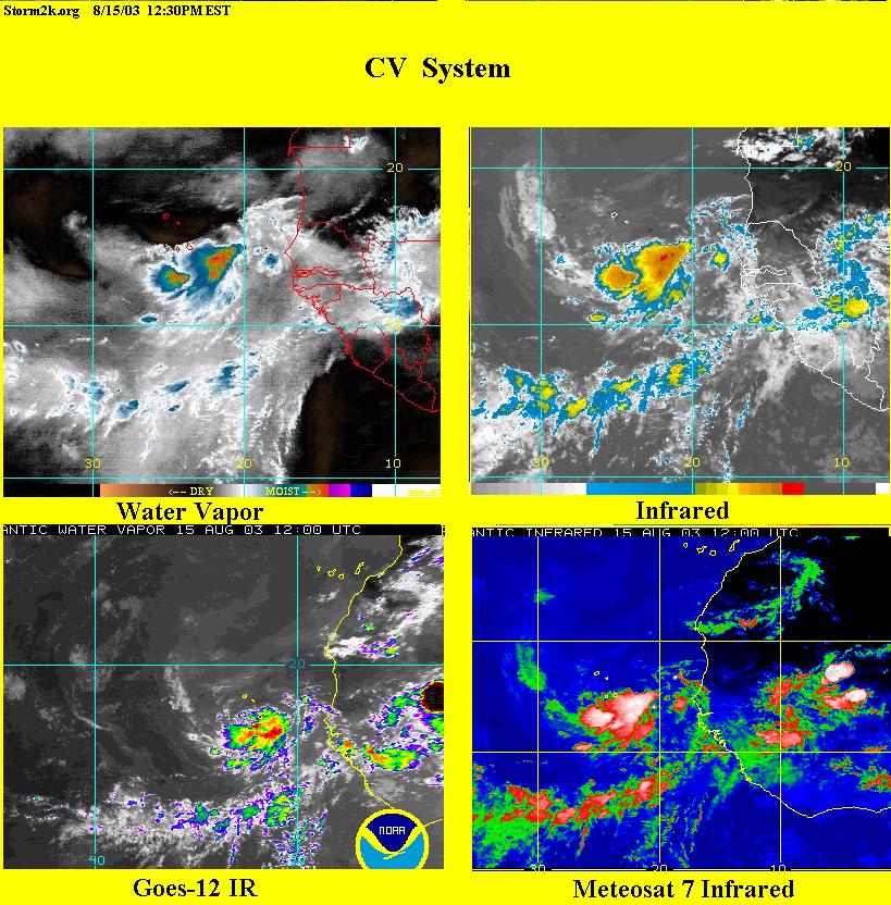
Steve H. wrote:Think it will develop. This morning's GFS had it eventually going up near the New England coast. Way too early to tell that yet. Didn't see the others overly aggressive with it. The NOGAPS showed it; CMC showed it initially then dissipated it, and the UKMET did the same. But they all show it, and I buy the GFS develops this year with the CV. Been pretty much on the mark. BTW, where do you get the images with that kind of layout? Drag and Drop thumbnails?? Looks great!!! And where do you get the tropical atlantic GFS. Not the one from the PSU site, but the one with the standard GFS layout?? Thanks in advance. Let's see what the 12Z shows
The 12z GFS layout is available at NCEP ... also, you can go to my tropical weather page for the individual time frames from the ETA/GFS ... Tropical Weather Section (it's toward the bottom of the page laid out in the time frames 00z, 06z, 12z, and 18z and 4 panel frames 00z, 06z, 12z, and 18z...
SF
0 likes
Hey Steve, made the image my self using capture express and Paint.. Glad you like it
Is this the link your looking for? http://www.nco.ncep.noaa.gov/pmb/nwprod ... /fpc.shtml

Is this the link your looking for? http://www.nco.ncep.noaa.gov/pmb/nwprod ... /fpc.shtml
0 likes
- cycloneye
- Admin
- Posts: 145336
- Age: 68
- Joined: Thu Oct 10, 2002 10:54 am
- Location: San Juan, Puerto Rico
http://www.storm2k.org/Weather-Central/ ... lantic.htm
The wave is not so organized at this time because it is elongated SW to NE and the circulation is not well defined so for now dont expect development from it until it gets more west if it develops at all.
0 likes
Visit the Caribbean-Central America Weather Thread where you can find at first post web cams,radars
and observations from Caribbean basin members Click Here
- wx247
- S2K Supporter
- Posts: 14279
- Age: 41
- Joined: Wed Feb 05, 2003 10:35 pm
- Location: Monett, Missouri
- Contact:
It still bears watching over the weekend.
Thanks for the graphics Chad.

0 likes
Personal Forecast Disclaimer:
The posts in this forum are NOT official forecast and should not be used as such. They are just the opinion of the poster and may or may not be backed by sound meteorological data. They are NOT endorsed by any professional institution or storm2k.org. For official information, please refer to the NHC and NWS products.
Who is online
Users browsing this forum: No registered users and 34 guests