

Question:
If the ridge verifies, how far west would it extend before the storm starts to head northerly?
ATL: Ex-DANIELLE - Models
Moderator: S2k Moderators

That HWRF probably turns far enough south to suggest it'd be a threat to the east coast as the subtropical ridge sets up far enough north to shunt this back westwards.
0 likes
Personal Forecast Disclaimer:
The posts in this forum are NOT official forecast and should not be used as such. They are just the opinion of the poster and may or may not be backed by sound meteorological data. They are NOT endorsed by any professional institution or storm2k.org. For official information, please refer to the NHC and NWS products
The posts in this forum are NOT official forecast and should not be used as such. They are just the opinion of the poster and may or may not be backed by sound meteorological data. They are NOT endorsed by any professional institution or storm2k.org. For official information, please refer to the NHC and NWS products
I don't know if anyone has mentioned the GFDL but it takes it to 25.5/56.5 heading NW but slowing right down as it reaches slacker conditions...hard to say where it'd go from there to be honest though!
Also gets upto a 3/4 hurricane with a 952mbs pressure.
Also gets upto a 3/4 hurricane with a 952mbs pressure.
0 likes
Personal Forecast Disclaimer:
The posts in this forum are NOT official forecast and should not be used as such. They are just the opinion of the poster and may or may not be backed by sound meteorological data. They are NOT endorsed by any professional institution or storm2k.org. For official information, please refer to the NHC and NWS products
The posts in this forum are NOT official forecast and should not be used as such. They are just the opinion of the poster and may or may not be backed by sound meteorological data. They are NOT endorsed by any professional institution or storm2k.org. For official information, please refer to the NHC and NWS products
-
Ivanhater

- Storm2k Moderator

- Posts: 11221
- Age: 39
- Joined: Fri Jul 01, 2005 8:25 am
- Location: Pensacola
Re: ATL: Tropical Depression SIX - Models
Yep..GFDL dropped the recurve from yesterday..bending back more toward the end

0 likes
Michael
Should be north enough though to probably recurve Ivanhater, but it will slow down and the NW motion may well carry on, not many systems are able to bend back west far enough to threat the states from that far north even when there are strong upper highs aloft.
Also GFDL shows this one getting to 14N before bending back WNW.
Also GFDL shows this one getting to 14N before bending back WNW.
0 likes
Personal Forecast Disclaimer:
The posts in this forum are NOT official forecast and should not be used as such. They are just the opinion of the poster and may or may not be backed by sound meteorological data. They are NOT endorsed by any professional institution or storm2k.org. For official information, please refer to the NHC and NWS products
The posts in this forum are NOT official forecast and should not be used as such. They are just the opinion of the poster and may or may not be backed by sound meteorological data. They are NOT endorsed by any professional institution or storm2k.org. For official information, please refer to the NHC and NWS products
-
cycloneye

- Admin

- Posts: 149592
- Age: 69
- Joined: Thu Oct 10, 2002 10:54 am
- Location: San Juan, Puerto Rico
Re: ATL: Tropical Depression SIX - Models
18z Tropical Models

Code: Select all
WHXX01 KWBC 221829
CHGHUR
TROPICAL CYCLONE GUIDANCE MESSAGE
NWS TPC/NATIONAL HURRICANE CENTER MIAMI FL
1829 UTC SUN AUG 22 2010

DISCLAIMER...NUMERICAL MODELS ARE SUBJECT TO LARGE ERRORS.
PLEASE REFER TO NHC OFFICIAL FORECASTS FOR TROPICAL CYCLONE
AND SUBTROPICAL CYCLONE INFORMATION.

ATLANTIC OBJECTIVE AIDS FOR

TROPICAL CYCLONE SIX (AL062010) 20100822 1800 UTC

        ...00 HRS...   ...12 HRS...   ...24 HRS. ..   ...36 HRS...
        100822  1800   100823  0600   100823  1800   100824  0600

         LAT    LON     LAT    LON     LAT    LON     LAT    LON
BAMS    13.2N  34.6W   14.2N  36.1W   15.6N  38.6W   17.3N  41.9W
BAMD    13.2N  34.6W   14.0N  36.6W   15.1N  39.0W   16.2N  41.5W
BAMM    13.2N  34.6W   14.2N  36.5W   15.4N  39.2W   16.7N  42.4W
LBAR    13.2N  34.6W   14.0N  36.9W   15.1N  40.1W   15.9N  43.2W
SHIP        30KTS          34KTS          42KTS          51KTS
DSHP        30KTS          34KTS          42KTS          51KTS

        ...48 HRS...   ...72 HRS...   ...96 HRS. ..   ..120 HRS...
        100824  1800   100825  1800   100826  1800   100827  1800

         LAT    LON     LAT    LON     LAT    LON     LAT    LON
BAMS    19.0N  45.6W   21.3N  52.5W   21.3N  57.1W   22.2N  57.1W
BAMD    17.7N  43.9W   21.3N  48.1W   24.8N  51.9W   28.0N  55.2W
BAMM    18.2N  45.6W   20.5N  50.9W   22.2N  54.4W   24.9N  55.5W
LBAR    17.2N  46.8W   19.6N  52.5W   23.5N  54.7W   26.2N  56.9W
SHIP        59KTS          69KTS          73KTS          73KTS
DSHP        59KTS          69KTS          73KTS          73KTS

         ...INITIAL CONDITIONS...
LATCUR =  13.2N LONCUR =  34.6W DIRCUR = 315DEG SPDCUR =  11KT
LATM12 =  11.7N LONM12 =  33.0W DIRM12 = 303DEG SPDM12 =   9KT
LATM24 =  10.8N LONM24 =  31.8W
WNDCUR =   30KT RMAXWD =   75NM WNDM12 =   30KT
CENPRS = 1007MB OUTPRS = 1012MB OUTRAD =  250NM SDEPTH =   S
RD34NE =    0NM RD34SE =    0NM RD34SW =    0NM RD34NW =   0NM
0 likes
Visit the Caribbean-Central America Weather Thread where you can find at first post web cams,radars
and observations from Caribbean basin members Click Here
and observations from Caribbean basin members Click Here
-
Ivanhater
- Storm2k Moderator
- Posts: 11221
- Age: 39
- Joined: Fri Jul 01, 2005 8:25 am
- Location: Pensacola
Re:
KWT wrote:Should be north enough though to probably recurve Ivanhater, but it will slow down and the NW motion may well carry on, not many systems are able to bend back west far enough to threat the states from that far north even when there are strong upper highs aloft.
Also GFDL shows this one getting to 14N before bending back WNW.
I'm not that concerned with the exact surface reflection. I'm looking at the trend. Just the GFDL for example had the recurving heading due north yesterday. First the HWRF switched bending back west, now the GFDL did. Keep in mind the northern biases these models have. That is why I could care less what latitude the surface reflection shows.
0 likes
Michael
-
Ivanhater
- Storm2k Moderator
- Posts: 11221
- Age: 39
- Joined: Fri Jul 01, 2005 8:25 am
- Location: Pensacola
Re: ATL: Tropical Depression SIX - Models
12z Euro stalls east of Bermuda and hooks left
Messy pattern
Messy pattern
0 likes
Michael
-
cycloneye
- Admin
- Posts: 149592
- Age: 69
- Joined: Thu Oct 10, 2002 10:54 am
- Location: San Juan, Puerto Rico
Re: ATL: Tropical Depression SIX - Models

0 likes
Visit the Caribbean-Central America Weather Thread where you can find at first post web cams,radars
and observations from Caribbean basin members Click Here
and observations from Caribbean basin members Click Here
ECM still starts to recurve at 240hrs moving slightly NE...for all the strength of the upper ridge that builds it doesn't matter because its north of the upper high Axis...and the upper block actually does just that and forces back into a recurve flow.
Interestingly the GFS ensembles are rather split on what to do as well with some bending back west and others going nearly due east...the ECM goes on the due east solution. Still its not going to escape due to the first trough.
Interestingly the GFS ensembles are rather split on what to do as well with some bending back west and others going nearly due east...the ECM goes on the due east solution. Still its not going to escape due to the first trough.
0 likes
Personal Forecast Disclaimer:
The posts in this forum are NOT official forecast and should not be used as such. They are just the opinion of the poster and may or may not be backed by sound meteorological data. They are NOT endorsed by any professional institution or storm2k.org. For official information, please refer to the NHC and NWS products
The posts in this forum are NOT official forecast and should not be used as such. They are just the opinion of the poster and may or may not be backed by sound meteorological data. They are NOT endorsed by any professional institution or storm2k.org. For official information, please refer to the NHC and NWS products
-
hurricaneCW
- Category 5

- Posts: 1799
- Joined: Wed Mar 03, 2010 6:20 am
- Location: Toms River, NJ
Re: ATL: Tropical Depression SIX - Models
We're probably going to deal with the shifting back and forth for a while. The Euro seems to follow the latest gfs, but that's just one run.
0 likes
What I will say is the ECM is very potent for sure, nice large hurricane there, wonder what the central pressure is?
0 likes
Personal Forecast Disclaimer:
The posts in this forum are NOT official forecast and should not be used as such. They are just the opinion of the poster and may or may not be backed by sound meteorological data. They are NOT endorsed by any professional institution or storm2k.org. For official information, please refer to the NHC and NWS products
The posts in this forum are NOT official forecast and should not be used as such. They are just the opinion of the poster and may or may not be backed by sound meteorological data. They are NOT endorsed by any professional institution or storm2k.org. For official information, please refer to the NHC and NWS products
-
hurricaneCW
- Category 5
- Posts: 1799
- Joined: Wed Mar 03, 2010 6:20 am
- Location: Toms River, NJ
Re: ATL: Tropical Depression SIX - Models
Given how strong the ECM makes this storm, it's best for everyone's sake that it stays well out to sea.
0 likes
-
ConvergenceZone
.gif)
- Category 5
- Posts: 5241
- Joined: Fri Jul 29, 2005 1:40 am
- Location: Northern California
The GFS ensembles 12z are much more supportive of a recurve solution looking at the mean, much to the east of the 06z by 216hrs, very close to the ECM.
Recurvature still the most likely solution....
http://raleighwx.easternuswx.com/models ... cal216.gif
Recurvature still the most likely solution....
http://raleighwx.easternuswx.com/models ... cal216.gif
0 likes
Personal Forecast Disclaimer:
The posts in this forum are NOT official forecast and should not be used as such. They are just the opinion of the poster and may or may not be backed by sound meteorological data. They are NOT endorsed by any professional institution or storm2k.org. For official information, please refer to the NHC and NWS products
The posts in this forum are NOT official forecast and should not be used as such. They are just the opinion of the poster and may or may not be backed by sound meteorological data. They are NOT endorsed by any professional institution or storm2k.org. For official information, please refer to the NHC and NWS products
-
weatherguy2
- Tropical Depression

- Posts: 72
- Joined: Sun Aug 01, 2010 2:45 am
Re: ATL: Tropical Depression SIX - Models
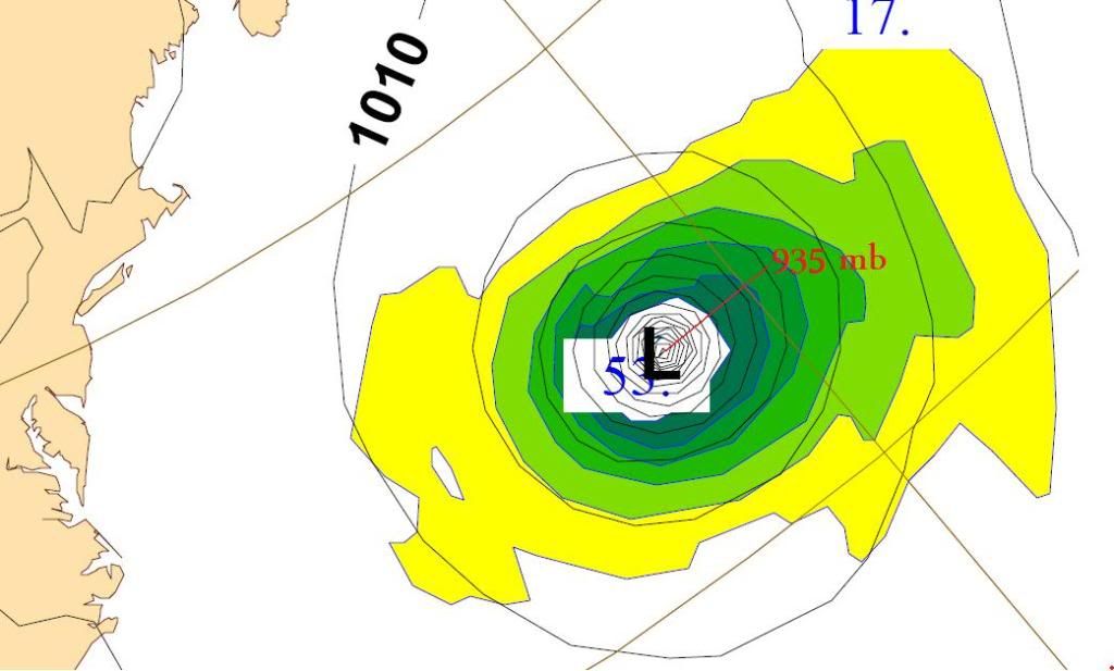
ECMWF appears to block it by the ridge at first, then it gets caught in a stronger trough later and starts to recurve. But it reaches typical Cat. 4 pressure at 935mb:
0 likes
Bermuda would be hit real hard if that occured, though the GFS ensemblws on the 12z have shifted back eastwards again.
0 likes
Personal Forecast Disclaimer:
The posts in this forum are NOT official forecast and should not be used as such. They are just the opinion of the poster and may or may not be backed by sound meteorological data. They are NOT endorsed by any professional institution or storm2k.org. For official information, please refer to the NHC and NWS products
The posts in this forum are NOT official forecast and should not be used as such. They are just the opinion of the poster and may or may not be backed by sound meteorological data. They are NOT endorsed by any professional institution or storm2k.org. For official information, please refer to the NHC and NWS products
-
Riptide

- Category 2

- Posts: 753
- Age: 34
- Joined: Fri Jul 23, 2010 3:33 pm
- Location: Cape May, New Jersey
- Contact:
Re:
KWT wrote:Bermuda would be hit real hard if that occured, though the GFS ensemblws on the 12z have shifted back eastwards again.
Despite this, the ensemble spread is actually wider with the majority of the ensemble members farther east obviously. I expect more trending and changes from the global models. 7-10 days is not sufficient.
0 likes
-
ConvergenceZone
- Category 5
- Posts: 5241
- Joined: Fri Jul 29, 2005 1:40 am
- Location: Northern California
Re:
KWT wrote:Bermuda would be hit real hard if that occured, though the GFS ensemblws on the 12z have shifted back eastwards again.
Who knows, they may shift back west tonight....
0 likes
Who is online
Users browsing this forum: No registered users and 34 guests