ATL: Ex-Hurricane DANIELLE - Discussion
Moderator: S2k Moderators
That convection is impressive to be fair, for now though shear is holding it back, if it weren't then I have few doubts we'd be in RI right now for this one but alas shear is still enough to hold it back...
0 likes
Personal Forecast Disclaimer:
The posts in this forum are NOT official forecast and should not be used as such. They are just the opinion of the poster and may or may not be backed by sound meteorological data. They are NOT endorsed by any professional institution or storm2k.org. For official information, please refer to the NHC and NWS products
The posts in this forum are NOT official forecast and should not be used as such. They are just the opinion of the poster and may or may not be backed by sound meteorological data. They are NOT endorsed by any professional institution or storm2k.org. For official information, please refer to the NHC and NWS products
Re: ATL : Tropical Storm DANIELLE - Discussion
the LLC still on the eastern side of the convection blob...not fully stacked but close....also watching a west wobble thrown in there once the CDO became established....heading into increasing shear...
http://cimss.ssec.wisc.edu/tropic/real- ... g8sht.html
http://cimss.ssec.wisc.edu/tropic/real- ... g8sht.html
0 likes
Re: ATL : Tropical Storm DANIELLE - Discussion
well "IF" the trough digs the western side of ridge will erode and slide east.
There is a closed ULL over the Bahamas at the moment with a continental ridge to the NW of that.
This is a typical setup with two large highs and a some kind of weakness/TUTT in between.
Given a whole week the atlantic ridge could move west or bridge with the continental ridge.
So far this season we have seen the weakness or TUTT amplify as a weak system approached E.G. Colin.
Danielle looks like it will be much stronger as it gets to the western edge of the Atlantic ridge and that is what brings up memories of major hurricanes that split ULL's or pumped up the Atlantic ridge.
I can't give an absolute percentage of major storms that bulled their way west but you tend to remember the big ones that made landfall. I would still go as high as 40% for an east coast landfall for Danielle.
Last edited by Nimbus on Sun Aug 22, 2010 8:12 pm, edited 1 time in total.
0 likes
- Blown Away
- S2K Supporter

- Posts: 10253
- Joined: Wed May 26, 2004 6:17 am
Re: ATL : Tropical Storm DANIELLE - Discussion
Tonight I think the fish solution is looking more likely. At least we will likely have a hurricane, maybe with an eye, to track!! Seems like forever since we had an Atlantic hurricane to track for days! Now that we are closing into September how is JB's predictions going to hold up?


0 likes
Hurricane Eye Experience: David 79, Irene 99, Frances 04, Jeanne 04, Wilma 05… Hurricane Brush Experience: Andrew 92, Erin 95, Floyd 99, Matthew 16, Irma 17, Ian 22, Nicole 22…
- cycloneye
- Admin

- Posts: 149614
- Age: 69
- Joined: Thu Oct 10, 2002 10:54 am
- Location: San Juan, Puerto Rico
Re: ATL : Tropical Storm DANIELLE - Discussion
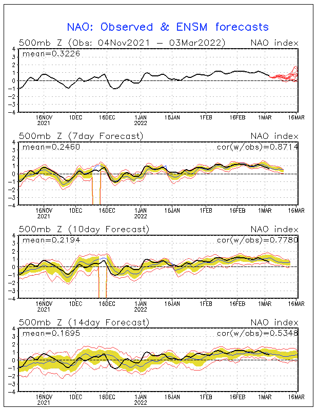
NAO (North Atlantic Occilation) is forecast to turn positive by early September. That will not allow for recurves, instead for Caribbean cruisers, typical of La Nina,but that is another topic for Talking Tropics forum.


0 likes
Visit the Caribbean-Central America Weather Thread where you can find at first post web cams,radars
and observations from Caribbean basin members Click Here
and observations from Caribbean basin members Click Here
-
OuterBanker
- S2K Supporter

- Posts: 1761
- Joined: Wed Feb 26, 2003 10:53 am
- Location: Nags Head, NC
- Contact:
Just an observation. But I can't remember the last time I've seen so much moisture. From Maine to Fl all of the gulf states and the wpac all lit up at the same time. The there's Danielle. The atmosphere has truly changed and rather drastically. Watch out for home brew this week, could sneak up on us.
0 likes
Re: ATL : Tropical Storm DANIELLE - Discussion
Blown Away wrote:Tonight I think the fish solution is looking more likely. At least we will likely have a hurricane, maybe with an eye, to track!! Seems like forever since we had an Atlantic hurricane to track for days! Now that we are closing into September how is JB's predictions going to hold up?
I swear I don't understand Accuweather. Those may be the vaguest predictions I've ever seen.
0 likes
- MiamiHurricanes10
- S2K Supporter

- Posts: 260
- Joined: Mon Jul 19, 2010 7:56 pm
- Location: Miami, Florida
- gatorcane
- S2K Supporter

- Posts: 23708
- Age: 48
- Joined: Sun Mar 13, 2005 3:54 pm
- Location: Boca Raton, FL
Folks be happy this trough will spare the us from the wrath of Danielle. Trust me she will become a whopper before all is said and done. It's fun tracking but not dealing with the aftermath should she have made landfall where you live.
Also as cycloneye pointed out early September should be interesting as recurves may become less likely. Don't forget the western caribbean also especially in October. I'm pretty confident the us and islands will have at least a couple of serious threats to deal with before this season is through.
Also as cycloneye pointed out early September should be interesting as recurves may become less likely. Don't forget the western caribbean also especially in October. I'm pretty confident the us and islands will have at least a couple of serious threats to deal with before this season is through.
Last edited by gatorcane on Sun Aug 22, 2010 8:41 pm, edited 2 times in total.
0 likes
-
Aric Dunn
- Category 5

- Posts: 21238
- Age: 43
- Joined: Sun Sep 19, 2004 9:58 pm
- Location: Ready for the Chase.
- Contact:
Re: ATL : Tropical Storm DANIELLE - Discussion
Ridge is almost over it.. but the circ is still under 15kts of shear...


0 likes
Re: ATL : Tropical Storm DANIELLE - Discussion
interesting how Miss Danielle is still moving WNW and not NW. Whats up with all the bandwagoneering of fish vs. westward shifts? They (shifts) will come as they always do! IMO I think the models from the earlier runs of the storm getting west with that huge high from the long range models page will pan out. Until then, Danielle looks good....
0 likes
- Blown Away
- S2K Supporter

- Posts: 10253
- Joined: Wed May 26, 2004 6:17 am
Re: ATL : Tropical Storm DANIELLE - Discussion
TexasF6 wrote:interesting how Miss Danielle is still moving WNW and not NW. Whats up with all the bandwagoneering of fish vs. westward shifts? They (shifts) will come as they always do! IMO I think the models from the earlier runs of the storm getting west with that huge high from the long range models page will pan out. Until then, Danielle looks good....
Fish seems pretty certain at this point, IMO. IMO the -NAO is keeping Danielle far far away, but the timing of the -NAO to +NAO seems to be happening just as things heat up. I think we will be wishing for these -NAO conditions in a week or 2 as systems move farther west.
0 likes
Hurricane Eye Experience: David 79, Irene 99, Frances 04, Jeanne 04, Wilma 05… Hurricane Brush Experience: Andrew 92, Erin 95, Floyd 99, Matthew 16, Irma 17, Ian 22, Nicole 22…
- Evil Jeremy
- S2K Supporter

- Posts: 5463
- Age: 32
- Joined: Mon Apr 10, 2006 2:10 pm
- Location: Los Angeles, CA
Re:
gatorcane wrote:I think the nhc will start to show a right hook in this advisory....indicating the recurve scenario is more likely
I don't think they would do that until there have been more consecutive model sets showing recurve. As it stands, no one would be effected by the storm's current path, so they don't need to rush into making the change now. If the models continue to trend east during the next couple of runs (I might be mistaken, but isn't it natural for the models to trend west during the 00z and 06z runs, and back east for the other two, or something like that?), then I think they would indicate a recurve on the cone. But not yet.
0 likes
Frances 04 / Jeanne 04 / Katrina 05 / Wilma 05 / Fay 08 / Debby 12 / Andrea 13 / Colin 16 / Hermine 16 / Matthew 16 / Irma 17
- Evil Jeremy
- S2K Supporter

- Posts: 5463
- Age: 32
- Joined: Mon Apr 10, 2006 2:10 pm
- Location: Los Angeles, CA
Re: ATL : Tropical Storm DANIELLE - Discussion
IMO, a recurve is as certain as that center reformation that many were pegging this morning.
0 likes
Frances 04 / Jeanne 04 / Katrina 05 / Wilma 05 / Fay 08 / Debby 12 / Andrea 13 / Colin 16 / Hermine 16 / Matthew 16 / Irma 17
-
Aric Dunn
- Category 5

- Posts: 21238
- Age: 43
- Joined: Sun Sep 19, 2004 9:58 pm
- Location: Ready for the Chase.
- Contact:
Re: ATL : Tropical Storm DANIELLE - Discussion
Evil Jeremy wrote:IMO, a recurve is as certain as that center reformation that many were pegging this morning.
there was no center reformation...
0 likes
- Evil Jeremy
- S2K Supporter

- Posts: 5463
- Age: 32
- Joined: Mon Apr 10, 2006 2:10 pm
- Location: Los Angeles, CA
Re: ATL : Tropical Storm DANIELLE - Discussion
Aric Dunn wrote:Evil Jeremy wrote:IMO, a recurve is as certain as that center reformation that many were pegging this morning.
there was no center reformation...
Thats my way of saying "its not certain".
0 likes
Frances 04 / Jeanne 04 / Katrina 05 / Wilma 05 / Fay 08 / Debby 12 / Andrea 13 / Colin 16 / Hermine 16 / Matthew 16 / Irma 17
Who is online
Users browsing this forum: No registered users and 61 guests

