
ATL: Ex Tropical Storm EARL - Discussion
Moderator: S2k Moderators
-
ConvergenceZone
.gif)
- Category 5

- Posts: 5241
- Joined: Fri Jul 29, 2005 1:40 am
- Location: Northern California
-
Gustywind

- Category 5
- Posts: 12334
- Joined: Mon Sep 03, 2007 7:29 am
- Location: Baie-Mahault, GUADELOUPE
Re: ATL: Tropical Storm EARL - Discussion
cycloneye wrote:The Northern Leewards are in the cone.
Absolutely Cycloneye we should pay attention us in the Leewards, PR and BVI but especially St Marteen and St Barth. Let's keep a close eye on Earl. During this period, tropics are always are full of surprises, we never know...
0 likes
-
Evil Jeremy

- S2K Supporter

- Posts: 5463
- Age: 32
- Joined: Mon Apr 10, 2006 2:10 pm
- Location: Los Angeles, CA
Re: ATL: Tropical Storm EARL - Discussion
Plant grower wrote:redfish1 wrote:could this possibly make a bee line towards the GOM?
At this point anything is fair game.
Not exactly. Some scenarios are still more likely than others. If everything was fair game, the models would be all over the place.
This is going to be an interesting system to predict. Its future really depends on what Danielle decides to do.
0 likes
Frances 04 / Jeanne 04 / Katrina 05 / Wilma 05 / Fay 08 / Debby 12 / Andrea 13 / Colin 16 / Hermine 16 / Matthew 16 / Irma 17
-
hurricaneCW
- Category 5
- Posts: 1799
- Joined: Wed Mar 03, 2010 6:20 am
- Location: Toms River, NJ
Re: ATL: Tropical Storm EARL - Discussion
The agreement is pretty much perfect all the way up to 60W, everything after really will depend on Danielle. I personally don't think she will linger as much as some of the models suggest and am siding with the Euro/Gfs on this one, more so the Euro.
0 likes
-
Evil Jeremy
- S2K Supporter
- Posts: 5463
- Age: 32
- Joined: Mon Apr 10, 2006 2:10 pm
- Location: Los Angeles, CA
Re: ATL: Tropical Storm EARL - Discussion
This is what I am thinking. There are a couple scenarios with Danielle. One has it recurving out to the Atlantic. If it does that quickly, the ridge can build in. If it does so slowly, it allows Earl to make a connection. If it gets left behind, wouldn't that send Earl west? So many possibilities on the future path of Earl, most of which have to do with another storm.
0 likes
Frances 04 / Jeanne 04 / Katrina 05 / Wilma 05 / Fay 08 / Debby 12 / Andrea 13 / Colin 16 / Hermine 16 / Matthew 16 / Irma 17
-
LowndesCoFire

- Tropical Storm

- Posts: 137
- Age: 44
- Joined: Tue Aug 19, 2008 5:03 pm
- Location: Valdosta, GA
Re: ATL: Tropical Storm EARL - Discussion
Look, its gonna recurve!!! YAY....2004 - Look familiar?? Six went on to be Frances landfalling on FL E Coast.
0 likes
The above post is personal opinion only and should be taken as such. Please refer to official forecasts from professional sources such as your local NWS office or the NHC.
-
jaxfladude
- Category 5
- Posts: 1249
- Joined: Wed Aug 24, 2005 9:36 pm
- Location: Jacksonville, Fla
Re: ATL: Tropical Depression SEVEN - Discussion
ROCK wrote:Frank2 wrote:1986 we had hurricane flights? nice...didnt know that....
You're joking, right???
NOAA flew research flights before the P-3's were put into service in 1977, and actually from what I was often told the old DC-6 was making eyewall penetrations since the 1960's (years before NOAA existed)...
http://www.aoml.noaa.gov/hrd/hrd_sub/stormfury_era.html
Dude....I was 12 in 1986....
Me too!
0 likes
Stay safe y'all
-
ConvergenceZone
- Category 5
- Posts: 5241
- Joined: Fri Jul 29, 2005 1:40 am
- Location: Northern California

Re: ATL: Tropical Depression SEVEN - Discussion
AdamFirst wrote:wxman57 wrote:
The Hebert Box is not a theory to believe or not - it's a fact. It doesn't predict the future, it just characterizes the past storm tracks. However, it can be used as a potential indicator for Florida hit (or miss). But like I said, the corollary is not true. Just because a storm enters the box doesn't mean it's going to hit Florida.
That's why I'm not much of a believer of it. Some posters on here I've seen treat it as bulletproof.

Thank you to both of you for clarying the "mystical" Hebert Box.
Some like to make it a corollary; "ugh oh, because the storm is in the box, we will be threatened!".
And that IS NOT TRUE!!
However, it has some statistical validity and coorelation between where a storm crosses and the increased chance that it will affect Florida. It isn't something you don't believe in, it is simply an indicator.
So, take it for what it is worth, strictly an indicator of increased statistical chance of an effect.
0 likes
Re: ATL: Tropical Storm EARL - Discussion
Cookie wrote:so we have Earl

WOW.
I have never seen a picture of Earl Hickey with his eyes open!!!!
0 likes
-
LowndesCoFire
- Tropical Storm
- Posts: 137
- Age: 44
- Joined: Tue Aug 19, 2008 5:03 pm
- Location: Valdosta, GA
Re:
ConvergenceZone wrote:LowndesCoFire
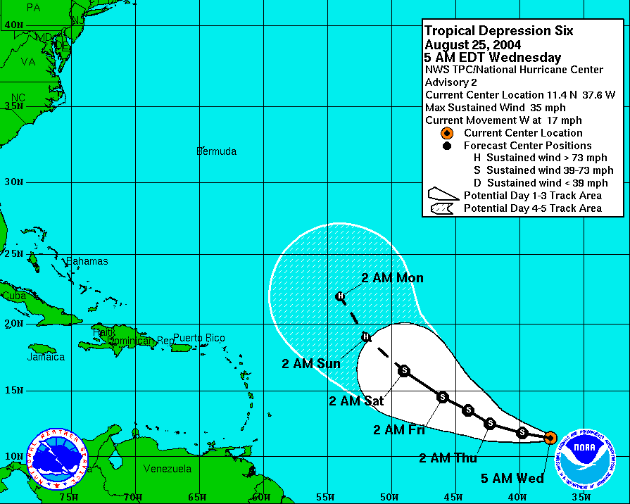
that track is quite a bit further north than Earl is...
Why are you posting that track? I'm confused. That's for td 6
That was TD 6 back in 2004 which was predicted to recurve prior to reaching 55W. Everyone is preaching Earl recurving, etc. etc...well, TD 6 evolved into Frances which made it to the FL East Coast and even Northeast GOM. Just showing that ANYTHING can happen.
0 likes
The above post is personal opinion only and should be taken as such. Please refer to official forecasts from professional sources such as your local NWS office or the NHC.
-
ConvergenceZone
- Category 5
- Posts: 5241
- Joined: Fri Jul 29, 2005 1:40 am
- Location: Northern California
Re: Re:
LowndesCoFire wrote:ConvergenceZone wrote:LowndesCoFire
that track is quite a bit further north than Earl is...
Why are you posting that track? I'm confused. That's for td 6
That was TD 6 back in 2004 which was predicted to recurve prior to reaching 55W. Everyone is preaching Earl recurving, etc. etc...well, TD 6 evolved into Frances which made it to the FL East Coast and even Northeast GOM. Just showing that ANYTHING can happen.
Oh okay, gotcha...
0 likes

Re: ATL: Tropical Storm EARL - Discussion
Being here in Gulf Shores, I can say that we just loves us some wind rain and days without power. 
0 likes
-
CrazyC83
- Professional-Met

- Posts: 34315
- Joined: Tue Mar 07, 2006 11:57 pm
- Location: Deep South, for the first time!
Re: ATL: Tropical Storm EARL - Discussion
Acral wrote:Being here in Gulf Shores, I can say that we just loves us some wind rain and days without power.
That IMO is the worst part of the hurricane aftermath. And you have to go wayyyyyyyy inland to avoid that...out of the track entirely. Look at Ike.
0 likes
-
cycloneye

- Admin

- Posts: 149472
- Age: 69
- Joined: Thu Oct 10, 2002 10:54 am
- Location: San Juan, Puerto Rico
Re: ATL: Tropical Storm EARL - Discussion
The latest.

0 likes
Visit the Caribbean-Central America Weather Thread where you can find at first post web cams,radars
and observations from Caribbean basin members Click Here
and observations from Caribbean basin members Click Here

Re: Re:
LowndesCoFire wrote:That was TD 6 back in 2004 which was predicted to recurve prior to reaching 55W. Everyone is preaching Earl recurving, etc. etc...well, TD 6 evolved into Frances which made it to the FL East Coast and even Northeast GOM. Just showing that ANYTHING can happen.
Yeah but the obvious difference with Frances is there was not a big hurricane to its north already, like there likely will be with Earl...
The NE Caribbean needs to be careful of this one, if it tracks a little further to the west then progged then it clearly needs watching!
WAY too early to call this one a fish, even though IMO a recurve is still the most likely option, probably by a big way as well...
0 likes
Personal Forecast Disclaimer:
The posts in this forum are NOT official forecast and should not be used as such. They are just the opinion of the poster and may or may not be backed by sound meteorological data. They are NOT endorsed by any professional institution or storm2k.org. For official information, please refer to the NHC and NWS products
The posts in this forum are NOT official forecast and should not be used as such. They are just the opinion of the poster and may or may not be backed by sound meteorological data. They are NOT endorsed by any professional institution or storm2k.org. For official information, please refer to the NHC and NWS products
-
bvigal

- S2K Supporter
- Posts: 2276
- Joined: Sun Jul 24, 2005 8:49 am
- Location: British Virgin Islands
- Contact:
Re: ATL: Tropical Depression SEVEN - Discussion
Yes, and that's far enough away for us in NE Carib not to worry, if it stays on that track or moves more to the right. Here's how I measure these. The track is from NHC advisory 2 GIS. Since the 120hr only goes so far, I extend the line. Now we know it will likely be curving, they don't usually go in a straight line. But, since I don't know how far it will curve, I just extend it straight to have something to measure with Google's ruler. In nautical miles, that puts closest point (on the straight line) to St. Martin and our out-island of Anegada about 160nm or 183 statute miles.wxman57 wrote:Latest GFS an EC take the center across 20N/60W. That's about 275 miles NE of the Caribbean islands.

0 likes
-
LowndesCoFire
- Tropical Storm
- Posts: 137
- Age: 44
- Joined: Tue Aug 19, 2008 5:03 pm
- Location: Valdosta, GA
Re: Re:
KWT wrote:LowndesCoFire wrote:That was TD 6 back in 2004 which was predicted to recurve prior to reaching 55W. Everyone is preaching Earl recurving, etc. etc...well, TD 6 evolved into Frances which made it to the FL East Coast and even Northeast GOM. Just showing that ANYTHING can happen.
Yeah but the obvious difference with Frances is there was not a big hurricane to its north already, like there likely will be with Earl...
The NE Caribbean needs to be careful of this one, if it tracks a little further to the west then progged then it clearly needs watching!
WAY too early to call this one a fish, even though IMO a recurve is still the most likely option, probably by a big way as well...
My post was merely a "look anything can happen post". I dont necessarily recall the dynamics from 6 years ago, but something had the NHC thinking recurve for Frances but then something pushed her into FL!
0 likes
The above post is personal opinion only and should be taken as such. Please refer to official forecasts from professional sources such as your local NWS office or the NHC.
Hmmmm 150 miles is easily close enough for it to shift about and become a threat though.
The only good thing is any major northwards wobbles will make a NE Caribbean hit fairly unlikely...it really does need to head close to due west from now on to be a threat...but I wouldn't rule it out.
This one needs to be watched like a hawk.
The only good thing is any major northwards wobbles will make a NE Caribbean hit fairly unlikely...it really does need to head close to due west from now on to be a threat...but I wouldn't rule it out.
This one needs to be watched like a hawk.
0 likes
Personal Forecast Disclaimer:
The posts in this forum are NOT official forecast and should not be used as such. They are just the opinion of the poster and may or may not be backed by sound meteorological data. They are NOT endorsed by any professional institution or storm2k.org. For official information, please refer to the NHC and NWS products
The posts in this forum are NOT official forecast and should not be used as such. They are just the opinion of the poster and may or may not be backed by sound meteorological data. They are NOT endorsed by any professional institution or storm2k.org. For official information, please refer to the NHC and NWS products
Who is online
Users browsing this forum: No registered users and 12 guests