Possible "Fiona" a future U.S/Island threat? (Is Invest 97L)

This is the general tropical discussion area. Anyone can take their shot at predicting a storms path.

Moderator: S2k Moderators

Forum rules

The posts in this forum are NOT official forecasts and should not be used as such. They are just the opinion of the poster and may or may not be backed by sound meteorological data. They are NOT endorsed by any professional institution or STORM2K. For official information, please refer to products from the National Hurricane Center and National Weather Service.

Help Support Storm2K
Message
Author
User avatar
GCANE
S2K Supporter
S2K Supporter
Posts: 11453
Joined: Mon Oct 22, 2007 8:03 am

Re: Possible "Fiona" a future U.S/Island threat?

#141 Postby GCANE » Thu Aug 26, 2010 11:00 am

Looks like LL Vorticity is lagging behind the convection.

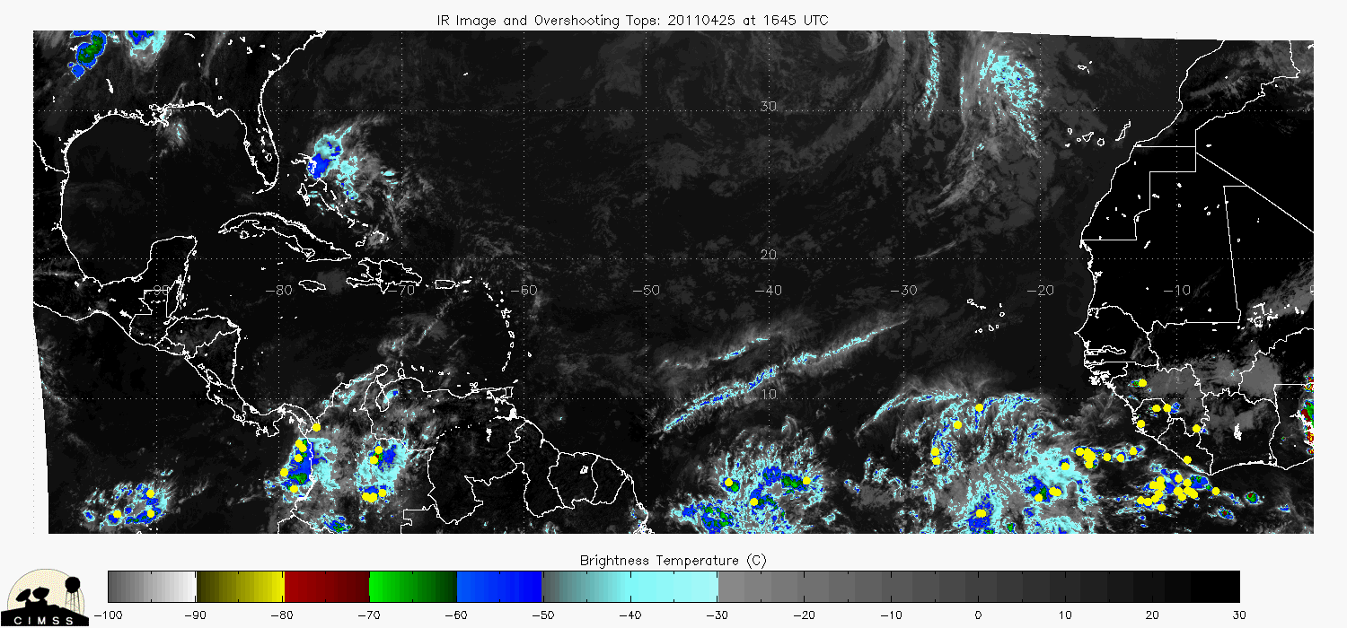
Actually going thru Dakar now.

LIDAR measurements at Dakar shows it passing thru an minimum in dust-concentration.

Time-section from Dakar indicates a very strong moisture column; very much like Danielle as she exited the coast.

Good conditions for creating a pouch.


Image


Image


Image


Image
0 likes   

User avatar
GCANE
S2K Supporter
S2K Supporter
Posts: 11453
Joined: Mon Oct 22, 2007 8:03 am

Re: Possible "Fiona" a future U.S/Island threat?

#142 Postby GCANE » Thu Aug 26, 2010 11:11 am

200mb winds are showing a "fan-out" pattern downstream of the convection.

IMHO this indicates a strengthening updraft and could develop into a strong anti-cyclone.

Image
0 likes   

User avatar
GCANE
S2K Supporter
S2K Supporter
Posts: 11453
Joined: Mon Oct 22, 2007 8:03 am

Re: Possible "Fiona" a future U.S/Island threat?

#143 Postby GCANE » Thu Aug 26, 2010 11:33 am

TRMM is showing a very high rain-rate cell at 9N 21.5W.

Typically, this indicates a hot-tower firing.

Also, a lot of overshooting tops are associated with the convection.

Good strong signature on microwave as well.

IMHO, this indicates a very good chance for this to spin up.


Image


Image


Image
0 likes   

User avatar
cycloneye
Admin
Admin
Posts: 143867
Age: 68
Joined: Thu Oct 10, 2002 10:54 am
Location: San Juan, Puerto Rico

Re: Possible "Fiona" a future U.S/Island threat?

#144 Postby cycloneye » Thu Aug 26, 2010 11:37 am

:uarrow: Those graphics above indicate that invest 97L is not far away from being up.
0 likes   
Visit the Caribbean-Central America Weather Thread where you can find at first post web cams,radars
and observations from Caribbean basin members Click Here

User avatar
GCANE
S2K Supporter
S2K Supporter
Posts: 11453
Joined: Mon Oct 22, 2007 8:03 am

Re: Possible "Fiona" a future U.S/Island threat?

#145 Postby GCANE » Thu Aug 26, 2010 11:41 am

36 hrs out, shear may be a bit of a problem, especially on the soth side of the LLC.

Image
0 likes   

User avatar
GCANE
S2K Supporter
S2K Supporter
Posts: 11453
Joined: Mon Oct 22, 2007 8:03 am

Re: Possible "Fiona" a future U.S/Island threat?

#146 Postby GCANE » Thu Aug 26, 2010 11:47 am

EURO ensembles, 200 hrs out, show a probable movement into the Bahamas; with even a chance for possible St Croix hit.

In reality, a lot can happen until then.


Image
0 likes   

User avatar
HURAKAN
Professional-Met
Professional-Met
Posts: 46086
Age: 38
Joined: Thu May 20, 2004 4:34 pm
Location: Key West, FL
Contact:

#147 Postby HURAKAN » Thu Aug 26, 2010 11:51 am

Image

wow
0 likes   

Brent
S2K Supporter
S2K Supporter
Posts: 37988
Age: 36
Joined: Sun May 16, 2004 10:30 pm
Location: Tulsa Oklahoma
Contact:

Re: Possible "Fiona" a future U.S/Island threat?

#148 Postby Brent » Thu Aug 26, 2010 12:18 pm

Dare I say this looks better than Earl?

Very very impressive.
0 likes   
#neversummer

User avatar
GCANE
S2K Supporter
S2K Supporter
Posts: 11453
Joined: Mon Oct 22, 2007 8:03 am

Re: Possible "Fiona" a future U.S/Island threat?

#149 Postby GCANE » Thu Aug 26, 2010 12:19 pm

Latest 320K PV Forecast shows the recurve kicking in when it enters the east Bahamas.

Wait and see.


Image
0 likes   

User avatar
cycloneye
Admin
Admin
Posts: 143867
Age: 68
Joined: Thu Oct 10, 2002 10:54 am
Location: San Juan, Puerto Rico

Re: Possible "Fiona" a future U.S/Island threat?

#150 Postby cycloneye » Thu Aug 26, 2010 12:21 pm

Is now invest 97L so thread is closed.
0 likes   
Visit the Caribbean-Central America Weather Thread where you can find at first post web cams,radars
and observations from Caribbean basin members Click Here


Return to “Talkin' Tropics”

Who is online

Users browsing this forum: No registered users and 197 guests