ATL: EARL - Models

Moderator: S2k Moderators

Message
Author
supercane
S2K Supporter
S2K Supporter
Posts: 2858
Joined: Wed Sep 16, 2009 8:27 pm

Re: ATL: EARL - Models

#401 Postby supercane » Thu Aug 26, 2010 4:15 pm

capepoint wrote:Many hurricanes move by the area from Cape lookout to Cape Hatteras, and althogh they stay "just offshore", we still get winds, tides, and rain. They are not counted as a landfall, but with the eye 10-20 miles offshore, we get plenty of damage from the west eyewall.


Relevant definitions from the NHC glossary:
Landfall:
The intersection of the surface center of a tropical cyclone with a coastline. Because the strongest winds in a tropical cyclone are not located precisely at the center, it is possible for a cyclone's strongest winds to be experienced over land even if landfall does not occur. Similarly, it is possible for a tropical cyclone to make landfall and have its strongest winds remain over the water. Compare direct hit, indirect hit, and strike.

Direct Hit:
A close approach of a tropical cyclone to a particular location. For locations on the left-hand side of a tropical cyclone's track (looking in the direction of motion), a direct hit occurs when the cyclone passes to within a distance equal to the cyclone's radius of maximum wind. For locations on the right-hand side of the track, a direct hit occurs when the cyclone passes to within a distance equal to twice the radius of maximum wind. Compare indirect hit, strike.

Indirect Hit:
Generally refers to locations that do not experience a direct hit from a tropical cyclone, but do experience hurricane force winds (either sustained or gusts) or tides of at least 4 feet above normal.
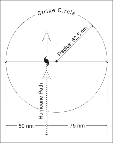
Strike:
For any particular location, a hurricane strike occurs if that location passes within the hurricane's strike circle, a circle of 125 n mi diameter, centered 12.5 n mi to the right of the hurricane center (looking in the direction of motion). This circle is meant to depict the typical extent of hurricane force winds, which are approximately 75 n mi to the right of the center and 50 n mi to the left.
Image


From these definitions, the case described would be a direct hit without landfall.
0 likes   

OuterBanker
S2K Supporter
S2K Supporter
Posts: 1731
Joined: Wed Feb 26, 2003 10:53 am
Location: Nags Head, NC
Contact:

#402 Postby OuterBanker » Thu Aug 26, 2010 4:31 pm

Wow, thanks supercane. That explains a lot. I wonder how insurance companies handle the different terms?

btw, anyone notice that the difference between the 06z and 12z gfs.

12 z looks like 500 miles west of 6z. Hope the trend reverses.
0 likes   

User avatar
Vortex
S2K Supporter
S2K Supporter
Posts: 4644
Age: 53
Joined: Fri Aug 01, 2003 9:34 pm
Location: Hilton Head, SC

#403 Postby Vortex » Thu Aug 26, 2010 5:19 pm

18Z GFS is very very close to the northern leewards...Folks down there had better be paying very close attention!
0 likes   

User avatar
ColinDelia
S2K Supporter
S2K Supporter
Posts: 918
Joined: Mon Aug 29, 2005 5:52 am
Location: The Beach, FL

Re: ATL: EARL - Models

#404 Postby ColinDelia » Thu Aug 26, 2010 5:21 pm

GFS. 90 hours from now

Image
Last edited by ColinDelia on Thu Aug 26, 2010 5:27 pm, edited 3 times in total.
0 likes   

User avatar
ColinDelia
S2K Supporter
S2K Supporter
Posts: 918
Joined: Mon Aug 29, 2005 5:52 am
Location: The Beach, FL

Re: ATL: EARL - Models

#405 Postby ColinDelia » Thu Aug 26, 2010 5:22 pm

102 hours

Image
Last edited by ColinDelia on Thu Aug 26, 2010 5:24 pm, edited 1 time in total.
0 likes   

User avatar
cycloneye
Admin
Admin
Posts: 145322
Age: 68
Joined: Thu Oct 10, 2002 10:54 am
Location: San Juan, Puerto Rico

Re: ATL: EARL - Models

#406 Postby cycloneye » Thu Aug 26, 2010 5:22 pm

Way close for comfort.
0 likes   
Visit the Caribbean-Central America Weather Thread where you can find at first post web cams,radars
and observations from Caribbean basin members Click Here

User avatar
Vortex
S2K Supporter
S2K Supporter
Posts: 4644
Age: 53
Joined: Fri Aug 01, 2003 9:34 pm
Location: Hilton Head, SC

#407 Postby Vortex » Thu Aug 26, 2010 5:23 pm

this trend is very alarming for island residents...lets see how the hwrf/gfdl 18z trend...
0 likes   

User avatar
ColinDelia
S2K Supporter
S2K Supporter
Posts: 918
Joined: Mon Aug 29, 2005 5:52 am
Location: The Beach, FL

Re: ATL: EARL - Models

#408 Postby ColinDelia » Thu Aug 26, 2010 5:23 pm

114 hours
Image
0 likes   

User avatar
CalmBeforeStorm
Category 2
Category 2
Posts: 600
Age: 71
Joined: Tue Aug 10, 2004 7:55 pm
Location: Stuart, Florida

#409 Postby CalmBeforeStorm » Thu Aug 26, 2010 5:24 pm

http://www.nco.ncep.noaa.gov/pmb/nwprod ... _126.shtml

The 18z gfs at 126 hours is looking like an east coast hit with Earl heading WnW and a fairly substantial high at 500 mb centered over the SE U.S. blocking a recurve at this point.
0 likes   

User avatar
TheDreamTraveler
Category 2
Category 2
Posts: 641
Joined: Sun Aug 22, 2010 3:10 am
Location: PA

Re: ATL: EARL - Models

#410 Postby TheDreamTraveler » Thu Aug 26, 2010 5:25 pm

The 12Z GFS is interesting...

Image

Image


But what's funny is, the ensembles are all to the East.


Image
0 likes   

User avatar
Vortex
S2K Supporter
S2K Supporter
Posts: 4644
Age: 53
Joined: Fri Aug 01, 2003 9:34 pm
Location: Hilton Head, SC

#411 Postby Vortex » Thu Aug 26, 2010 5:25 pm

If this pattern takes shape as the 18Z is indicating I assure you the 00Z gfs will trend further S and W.
0 likes   

User avatar
ColinDelia
S2K Supporter
S2K Supporter
Posts: 918
Joined: Mon Aug 29, 2005 5:52 am
Location: The Beach, FL

#412 Postby ColinDelia » Thu Aug 26, 2010 5:26 pm

Ensembles are really interesting!
0 likes   

User avatar
AdamFirst
S2K Supporter
S2K Supporter
Posts: 2491
Age: 36
Joined: Thu Aug 14, 2008 10:54 am
Location: Port Saint Lucie, FL

#413 Postby AdamFirst » Thu Aug 26, 2010 5:28 pm

18z GFS has it beginning the northward lift at 120hr, north of Puerto Rico.

Image
Image

I may be wrong but I think the 12z had the lift north of the Virgin Islands.
0 likes   
Dolphins Marlins Canes Golden Panthers HEAT
Andrew 1992 - Irene 1999 - Frances 2004 - Jeanne 2004 - Wilma 2005 - Fay 2008 - Isaac 2012 - Matthew 2016 - Irma 2017 - Dorian 2019 - Ian 2022 - Nicole 2022 - Milton 2024

User avatar
KWT
Category 5
Category 5
Posts: 31415
Joined: Tue Aug 17, 2004 11:02 am
Location: UK!!!

#414 Postby KWT » Thu Aug 26, 2010 5:31 pm

It is pretty close it has to be said, another 24hrs on a north of west track would have it hitting the islands on that track....
0 likes   
Personal Forecast Disclaimer:
The posts in this forum are NOT official forecast and should not be used as such. They are just the opinion of the poster and may or may not be backed by sound meteorological data. They are NOT endorsed by any professional institution or storm2k.org. For official information, please refer to the NHC and NWS products

User avatar
ColinDelia
S2K Supporter
S2K Supporter
Posts: 918
Joined: Mon Aug 29, 2005 5:52 am
Location: The Beach, FL

Re: ATL: EARL - Models

#415 Postby ColinDelia » Thu Aug 26, 2010 5:32 pm

132 hours
Image
0 likes   

User avatar
ColinDelia
S2K Supporter
S2K Supporter
Posts: 918
Joined: Mon Aug 29, 2005 5:52 am
Location: The Beach, FL

Re: ATL: EARL - Models

#416 Postby ColinDelia » Thu Aug 26, 2010 5:33 pm

144 hours

Image
0 likes   

User avatar
KWT
Category 5
Category 5
Posts: 31415
Joined: Tue Aug 17, 2004 11:02 am
Location: UK!!!

#417 Postby KWT » Thu Aug 26, 2010 5:33 pm

18z GFS still shows how hard it is going to be to get this towards the E.Coast though, the upper ridging is but gone by 168hrs and the upper trough is totally in charge so should recurve away at 70W this run.
0 likes   
Personal Forecast Disclaimer:
The posts in this forum are NOT official forecast and should not be used as such. They are just the opinion of the poster and may or may not be backed by sound meteorological data. They are NOT endorsed by any professional institution or storm2k.org. For official information, please refer to the NHC and NWS products

User avatar
ColinDelia
S2K Supporter
S2K Supporter
Posts: 918
Joined: Mon Aug 29, 2005 5:52 am
Location: The Beach, FL

Re: ATL: EARL - Models

#418 Postby ColinDelia » Thu Aug 26, 2010 5:40 pm

168 hours
Image
0 likes   

User avatar
ColinDelia
S2K Supporter
S2K Supporter
Posts: 918
Joined: Mon Aug 29, 2005 5:52 am
Location: The Beach, FL

Re: ATL: EARL - Models

#419 Postby ColinDelia » Thu Aug 26, 2010 5:50 pm

Image
0 likes   

I Scream Cone
Tropical Low
Tropical Low
Posts: 12
Joined: Mon Aug 23, 2010 5:46 am

#420 Postby I Scream Cone » Thu Aug 26, 2010 5:50 pm

KWT, with all due respect, what exactly is going to weaken the ridge at 168 hrs??? Looks to me like a very strong high pressure ridge...please correct me if I'm wrong. They have Earl busting through a power ridge for no apparent reason, and what is the cause for Earl's stall between 144-168hr???
0 likes   


Return to “2010”

Who is online

Users browsing this forum: No registered users and 2 guests