ATL: Ex-Hurricane DANIELLE - Discussion
Moderator: S2k Moderators
-
cyclonic chronic

Re: ATL: Hurricane DANIELLE - Discussion
Firing all eight cylinders now.
Reminds me of a West-Pac Marianas TC.


Reminds me of a West-Pac Marianas TC.
0 likes
-
MGC

- S2K Supporter

- Posts: 5940
- Joined: Sun Mar 23, 2003 9:05 pm
- Location: Pass Christian MS, or what is left.
Re: ATL: Hurricane DANIELLE - Discussion
Impressive hurricane indeed.....I'd keep it at cat 4 despite recon only finding 117KTS at flight level. Remembe that recon is only sampleing a small area of the hurricane and higer winds likely exist elsewhere. That microwave image looks like an eyewall replacement cycle might be starting.....MGC
0 likes
-
ColinDelia

- S2K Supporter
- Posts: 918
- Joined: Mon Aug 29, 2005 5:52 am
- Location: The Beach, FL
Re: ATL: Hurricane DANIELLE - Discussion
Of course we've just had recon but ... to look for future changes:


T5 90kts
T5.5 102 kts
T6 115 kts
T6.5 127 kts
T7 140 kts
T7.5 155 kts
T8 170 kts
T5 90kts
T5.5 102 kts
T6 115 kts
T6.5 127 kts
T7 140 kts
T7.5 155 kts
T8 170 kts
0 likes
-
dixiebreeze

- S2K Supporter
- Posts: 5140
- Joined: Wed Sep 03, 2003 5:07 pm
- Location: crystal river, fla.
Re: ATL: Hurricane DANIELLE - Discussion
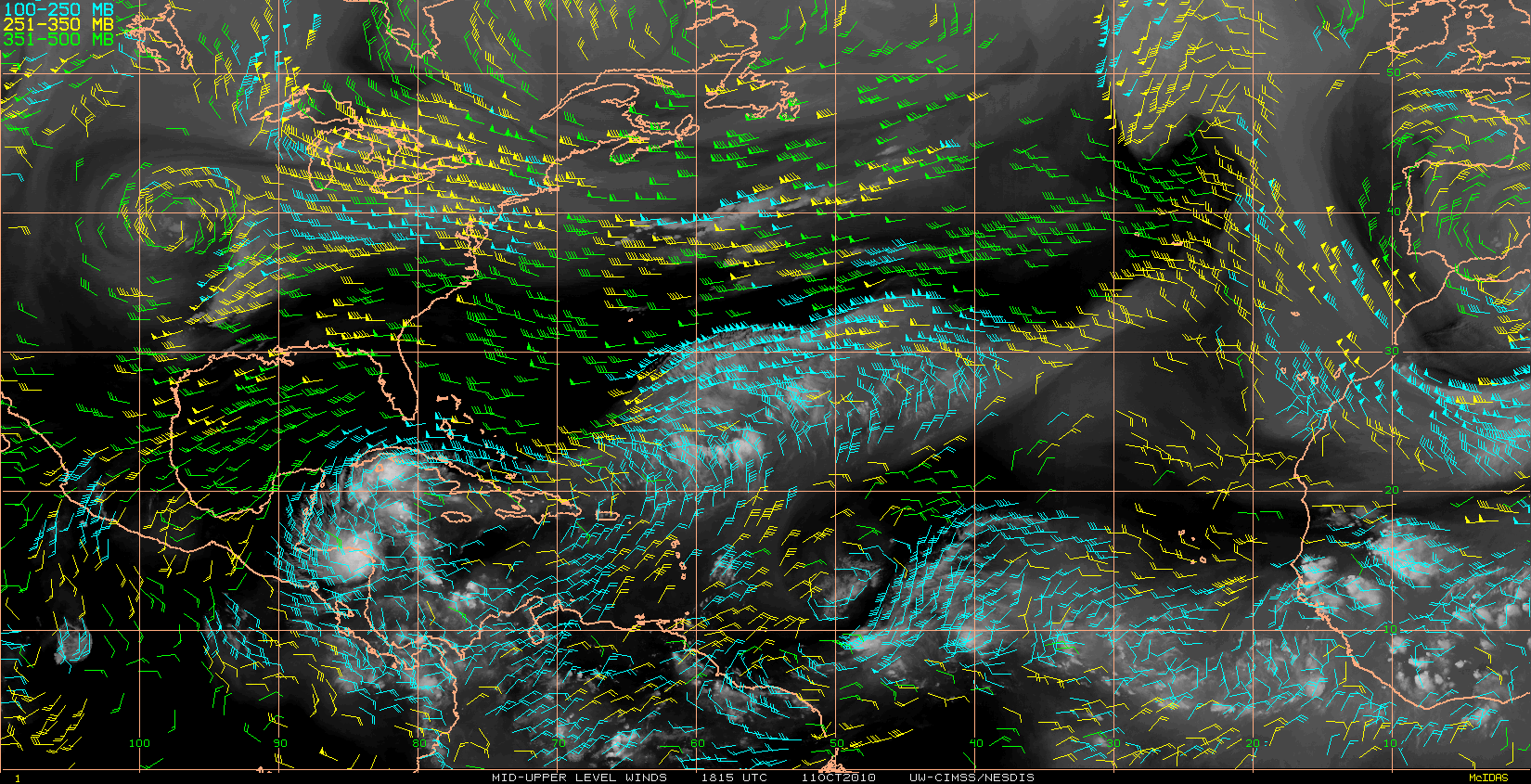
Interesting pic of Danielle's eye in ASCAT -- she's getting close to 60 degree latitude.
http://manati.orbit.nesdis.noaa.gov/asc ... MBas25.png
http://manati.orbit.nesdis.noaa.gov/asc ... MBas25.png
0 likes


-
theregulator

- Tropical Wave

- Posts: 6
- Age: 53
- Joined: Thu Aug 26, 2010 2:10 pm
- Location: Everett, WA
- Contact:
Re: ATL: Hurricane DANIELLE - Discussion
TheBurn wrote:
For a storm that wasn't supposed to go west of 60, she sure does look like she's pushing the line. Have the forecasts calling for a west / NW track for another 24 hours deviated or is that still in line with what we're seeing? She looks to have slowed - current models basically put it at practically turning on a dime, yet she seems to still be moving W to WNW.
0 likes
-
ColinDelia
- S2K Supporter
- Posts: 918
- Joined: Mon Aug 29, 2005 5:52 am
- Location: The Beach, FL
Re: ATL: Hurricane DANIELLE - Discussion
Forecast points
INITIAL 27/1500Z 26.9N 59.8W 115 KT
12HR VT 28/0000Z 27.9N 60.8W 115 KT
24HR VT 28/1200Z 29.5N 61.2W 115 KT
36HR VT 29/0000Z 31.5N 60.3W 110 KT
And some additional west in the in-between 12 hours
INITIAL 27/1500Z 26.9N 59.8W 115 KT
12HR VT 28/0000Z 27.9N 60.8W 115 KT
24HR VT 28/1200Z 29.5N 61.2W 115 KT
36HR VT 29/0000Z 31.5N 60.3W 110 KT
And some additional west in the in-between 12 hours
0 likes
-
ColinDelia
- S2K Supporter
- Posts: 918
- Joined: Mon Aug 29, 2005 5:52 am
- Location: The Beach, FL
-
plasticup
Re:
ColinDelia wrote:Yeah, some strengthening. The area of cold tops (dark orange in the AVN color) is expanding. The eye is further from the dense clouds
Hmmm, I dunno. It's definitely getting bigger, but is it getting stronger? The really powerful convection that we saw earlier near the core has died down a bit.
But WOW, it really is growing.
0 likes
-
tolakram
- Admin

- Posts: 20186
- Age: 62
- Joined: Sun Aug 27, 2006 8:23 pm
- Location: Florence, KY (name is Mark)
Re: Re:
plasticup wrote:Hmmm, I dunno. It's definitely getting bigger, but is it getting stronger? The really powerful convection that we saw earlier near the core has died down a bit.
But WOW, it really is growing.
It is getting stronger. When you're dealing with a large and powerful storm like Danielle, in my observations, it's not the super cold cloud tops but the size and persistence of the strong convection. The engine isn't revving high, it's in overdrive, but the car is now moving fast and getting faster.

0 likes
M a r k
- - - - -
Join us in chat: Storm2K Chatroom Invite. Android and IOS apps also available.
The posts in this forum are NOT official forecasts and should not be used as such. Posts are NOT endorsed by any professional institution or STORM2K.org. For official information and forecasts, please refer to NHC and NWS products.
-
plasticup

Re: ATL: Hurricane DANIELLE - Discussion
i was a cheerleader of the westward progress since yesterday evening..but i will be the first to say i think she just hit a brick wall!
she slowed ..spun ...and now "here comes the turn"?......or sit and spin? lol
she slowed ..spun ...and now "here comes the turn"?......or sit and spin? lol
Last edited by cpdaman on Fri Aug 27, 2010 3:07 pm, edited 1 time in total.
0 likes
-
Ivanhater

- Storm2k Moderator

- Posts: 11221
- Age: 39
- Joined: Fri Jul 01, 2005 8:25 am
- Location: Pensacola
Re: ATL: Hurricane DANIELLE - Discussion
Beautiful storm. Storms like these that you can watch from a safe distance.
0 likes
Michael

Last recon vortex message:
Product: Air Force Vortex Message (URNT12 KNHC)
Transmitted: 27th day of the month at 18:01Z
Aircraft: Air Force Aircraft (Last 3 digits of the tail number are 305)
Storm Number & Year: 06L in 2010
Storm Name: Danielle (flight in the North Atlantic basin)
Mission Number: 1
Observation Number: 11
A. Time of Center Fix: 27th day of the month at 17:35:30Z
B. Center Fix Coordinates: 26°59'N 60°05'W (26.9833N 60.0833W)
B. Center Fix Location: 464 miles (747 km) to the SE (142°) from Hamilton, Bermuda (GBR).
C. Minimum Height at Standard Level: 2,615m (8,579ft) at 700mb
D. Estimated (by SFMR or visually) Maximum Surface Wind: 101kts (~ 116.2mph)
E. Location of the Estimated Maximum Surface Wind: 9 nautical miles (10 statute miles) to the NW (325°) of center fix
F. Maximum Flight Level Wind Inbound: From 58° at 107kts (From the ENE at ~ 123.1mph)
G. Location of Maximum Flight Level Wind Inbound: 12 nautical miles (14 statute miles) to the NW (322°) of center fix
H. Minimum Sea Level Pressure: 942mb (27.82 inHg)
I. Maximum Flight Level Temp & Pressure Altitude Outside Eye: 10°C (50°F) at a pressure alt. of 3,055m (10,023ft)
J. Maximum Flight Level Temp & Pressure Altitude Inside Eye: 20°C (68°F) at a pressure alt. of 3,040m (9,974ft)
K. Dewpoint Temp (collected at same location as temp inside eye): 13°C (55°F)
K. Sea Surface Temp (collected at same location as temp inside eye): Not Available
L. Eye Character: Closed Wall
M. Eye Shape & Diameter: Circular with a diameter of 18 nautical miles (21 statute miles)
N. Fix Determined By: Penetration, Radar, Wind, Pressure and Temperature
N. Fix Level: 700mb
O. Navigation Fix Accuracy: 0.02 nautical miles
O. Meteorological Accuracy: 1 nautical mile
Remarks Section:
Maximum Flight Level Wind: 119kts (~ 136.9mph) in the northeast quadrant at 15:52:50Z
Maximum Flight Level Wind Outbound: 109kts (~ 125.4mph) in the southeast quadrant at 17:44:10Z
Pic from recon thread
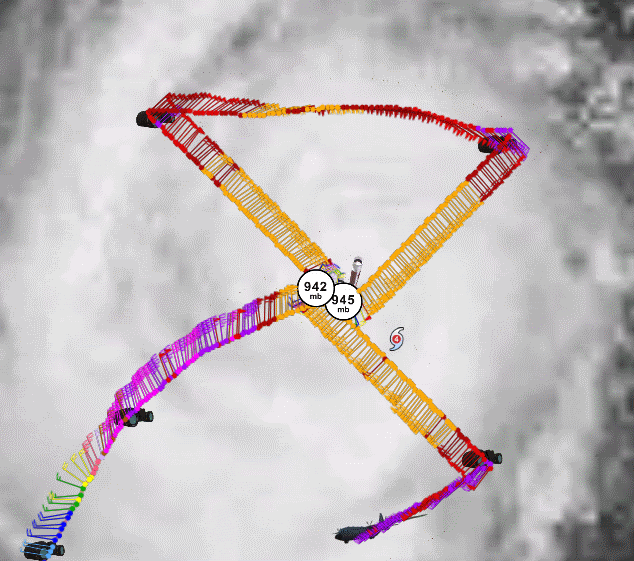
So far, deepening system with pressure down from 945 to 942 mb, peak flight-level wind of 119kt, peak SFMR wind 101kt. Again, normal flight-level wind reduction of 90% would result in surface wind of ~107kt. Given improved satellite appearance, agree with NHC decision (if best track is right) to keep advisory MSW at 115kt, even though such winds have yet to be found (maybe not mixing down to the surface?).
Product: Air Force Vortex Message (URNT12 KNHC)
Transmitted: 27th day of the month at 18:01Z
Aircraft: Air Force Aircraft (Last 3 digits of the tail number are 305)
Storm Number & Year: 06L in 2010
Storm Name: Danielle (flight in the North Atlantic basin)
Mission Number: 1
Observation Number: 11
A. Time of Center Fix: 27th day of the month at 17:35:30Z
B. Center Fix Coordinates: 26°59'N 60°05'W (26.9833N 60.0833W)
B. Center Fix Location: 464 miles (747 km) to the SE (142°) from Hamilton, Bermuda (GBR).
C. Minimum Height at Standard Level: 2,615m (8,579ft) at 700mb
D. Estimated (by SFMR or visually) Maximum Surface Wind: 101kts (~ 116.2mph)
E. Location of the Estimated Maximum Surface Wind: 9 nautical miles (10 statute miles) to the NW (325°) of center fix
F. Maximum Flight Level Wind Inbound: From 58° at 107kts (From the ENE at ~ 123.1mph)
G. Location of Maximum Flight Level Wind Inbound: 12 nautical miles (14 statute miles) to the NW (322°) of center fix
H. Minimum Sea Level Pressure: 942mb (27.82 inHg)
I. Maximum Flight Level Temp & Pressure Altitude Outside Eye: 10°C (50°F) at a pressure alt. of 3,055m (10,023ft)
J. Maximum Flight Level Temp & Pressure Altitude Inside Eye: 20°C (68°F) at a pressure alt. of 3,040m (9,974ft)
K. Dewpoint Temp (collected at same location as temp inside eye): 13°C (55°F)
K. Sea Surface Temp (collected at same location as temp inside eye): Not Available
L. Eye Character: Closed Wall
M. Eye Shape & Diameter: Circular with a diameter of 18 nautical miles (21 statute miles)
N. Fix Determined By: Penetration, Radar, Wind, Pressure and Temperature
N. Fix Level: 700mb
O. Navigation Fix Accuracy: 0.02 nautical miles
O. Meteorological Accuracy: 1 nautical mile
Remarks Section:
Maximum Flight Level Wind: 119kts (~ 136.9mph) in the northeast quadrant at 15:52:50Z
Maximum Flight Level Wind Outbound: 109kts (~ 125.4mph) in the southeast quadrant at 17:44:10Z
Pic from recon thread
So far, deepening system with pressure down from 945 to 942 mb, peak flight-level wind of 119kt, peak SFMR wind 101kt. Again, normal flight-level wind reduction of 90% would result in surface wind of ~107kt. Given improved satellite appearance, agree with NHC decision (if best track is right) to keep advisory MSW at 115kt, even though such winds have yet to be found (maybe not mixing down to the surface?).
0 likes
Who is online
Users browsing this forum: No registered users and 28 guests