While I haven't issued any NHC products, my experience with other NWS warning products would lead me to believe that the line discussing distances is automatically generated. You'll have to take things up with the person who programmed the location files.bvigal wrote:Don't these people study geography? Fix position both 12z and 18z, 15.7N, is east of ALL the Leeward Islands. And if you count Dominica, which some do, it extends to 15.6N.THE CENTER OF TROPICAL STORM EARL AT 27/1500 UTC IS NEAR 15.7N 43.6W...OR ABOUT 1430 MILES EAST OF THE NORTHERN LEEWARD ISLANDS...
FOR ADDITIONAL INFORMATION PLEASE VISIT
HTTP://WWW.HURRICANES.GOV/MARINE
$$
GARCIA
ATL: Ex Tropical Storm EARL - Discussion
Moderator: S2k Moderators
-
thetruesms

- Professional-Met

- Posts: 844
- Age: 42
- Joined: Thu Aug 16, 2007 1:14 pm
- Location: Tallahasee, FL
- Contact:
Re: Re:
0 likes
-
Gustywind

- Category 5

- Posts: 12334
- Joined: Mon Sep 03, 2007 7:29 am
- Location: Baie-Mahault, GUADELOUPE
000
WTNT32 KNHC 272030
TCPAT2
BULLETIN
TROPICAL STORM EARL ADVISORY NUMBER 10
NWS TPC/NATIONAL HURRICANE CENTER MIAMI FL AL072010
500 PM AST FRI AUG 27 2010
...EARL RACING WESTWARD OVER THE TROPICAL ATLANTIC WITH NO CHANGE IN
STRENGTH YET...
SUMMARY OF 500 PM AST...2100 UTC...INFORMATION
----------------------------------------------
LOCATION...15.8N 46.0W
ABOUT 1140 MI...1835 KM E OF THE NORTHERN LEEWARD ISLANDS
MAXIMUM SUSTAINED WINDS...45 MPH...75 KM/HR
PRESENT MOVEMENT...W OR 270 DEGREES AT 20 MPH...32 KM/HR
MINIMUM CENTRAL PRESSURE...1003 MB...29.62 INCHES
0 likes

-
AdamFirst

- S2K Supporter

- Posts: 2490
- Age: 36
- Joined: Thu Aug 14, 2008 10:54 am
- Location: Port Saint Lucie, FL
Re: ATL: Tropical Storm EARL - Discussion
Is that a TS watch box up for the Virgin Islands?
0 likes
Dolphins Marlins Canes Golden Panthers HEAT
Andrew 1992 - Irene 1999 - Frances 2004 - Jeanne 2004 - Wilma 2005 - Fay 2008 - Isaac 2012 - Matthew 2016 - Irma 2017 - Dorian 2019 - Ian 2022 - Nicole 2022 - Milton 2024
Andrew 1992 - Irene 1999 - Frances 2004 - Jeanne 2004 - Wilma 2005 - Fay 2008 - Isaac 2012 - Matthew 2016 - Irma 2017 - Dorian 2019 - Ian 2022 - Nicole 2022 - Milton 2024
-
ColinDelia

- S2K Supporter
- Posts: 918
- Joined: Mon Aug 29, 2005 5:52 am
- Location: The Beach, FL
THE GOVERNMENT OF FRANCE HAS ISSUED A TROPICAL STORM WATCH FOR
FRENCH SAINT MARTIN AND SAINT BARTHELEMY. THIS TROPICAL STORM WATCH
MEANS THAT TROPICAL STORM CONDITIONS ARE POSSIBLE WITHIN 72 HOURS.
SUMMARY OF WATCHES AND WARNINGS IN EFFECT...
A TROPICAL STORM WATCH IS IN EFFECT FOR...
* FRENCH SAINT MARTIN AND SAINT BARTHELEMY
FRENCH SAINT MARTIN AND SAINT BARTHELEMY. THIS TROPICAL STORM WATCH
MEANS THAT TROPICAL STORM CONDITIONS ARE POSSIBLE WITHIN 72 HOURS.
SUMMARY OF WATCHES AND WARNINGS IN EFFECT...
A TROPICAL STORM WATCH IS IN EFFECT FOR...
* FRENCH SAINT MARTIN AND SAINT BARTHELEMY
0 likes

Re: ATL: Tropical Storm EARL - Discussion
More and more it looks like we're going to be affected.
0 likes
-
Ivanhater

- Storm2k Moderator

- Posts: 11221
- Age: 39
- Joined: Fri Jul 01, 2005 8:25 am
- Location: Pensacola
Re: ATL: Tropical Storm EARL - Discussion
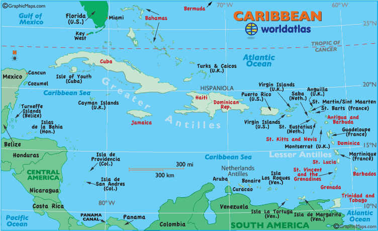
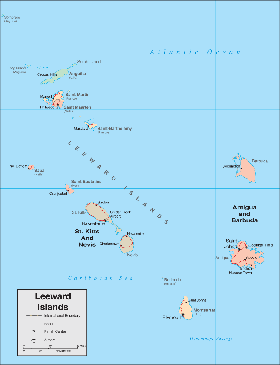
Can one of you Islanders post a detailed map of the NE Islands to show the area under watches?
0 likes
Michael


Re: ATL: Tropical Storm EARL - Discussion
Ivanhater wrote:Can one of you Islanders post a detailed map of the NE Islands to show the area under watches?
http://www.worldatlas.com/webimage/countrys/carib.htm
0 likes

-
Gustywind
- Category 5
- Posts: 12334
- Joined: Mon Sep 03, 2007 7:29 am
- Location: Baie-Mahault, GUADELOUPE
Re: ATL: Tropical Storm EARL - Discussion
fd122 wrote:More and more it looks like we're going to be affected.
Let's hope no
In spite of the Northern Leewards, Barbuda looks very well exposed too as Antigua given the latest projected path of the NHC. This thing is racing west very quickly at 32 km/h and is already on the 46W. At this rate it could be near the 49,5/ 50 W tommorow morning?! Intensity continues to be hopefully modest but the more it stays west the more chances it has to churn near all the Leewards. Let's continue to monitor closely Earl hoping for the best and keeping our fingers crossed.
0 likes
-
cycloneye

- Admin

- Posts: 149472
- Age: 69
- Joined: Thu Oct 10, 2002 10:54 am
- Location: San Juan, Puerto Rico
Re: ATL: Tropical Storm EARL - Discussion
For those who live in the islands,here is the 5 PM track of the miles from islands data.
http://stormcarib.com/closest2.htm
http://stormcarib.com/closest2.htm
0 likes
Visit the Caribbean-Central America Weather Thread where you can find at first post web cams,radars
and observations from Caribbean basin members Click Here
and observations from Caribbean basin members Click Here


-
cycloneye
- Admin
- Posts: 149472
- Age: 69
- Joined: Thu Oct 10, 2002 10:54 am
- Location: San Juan, Puerto Rico
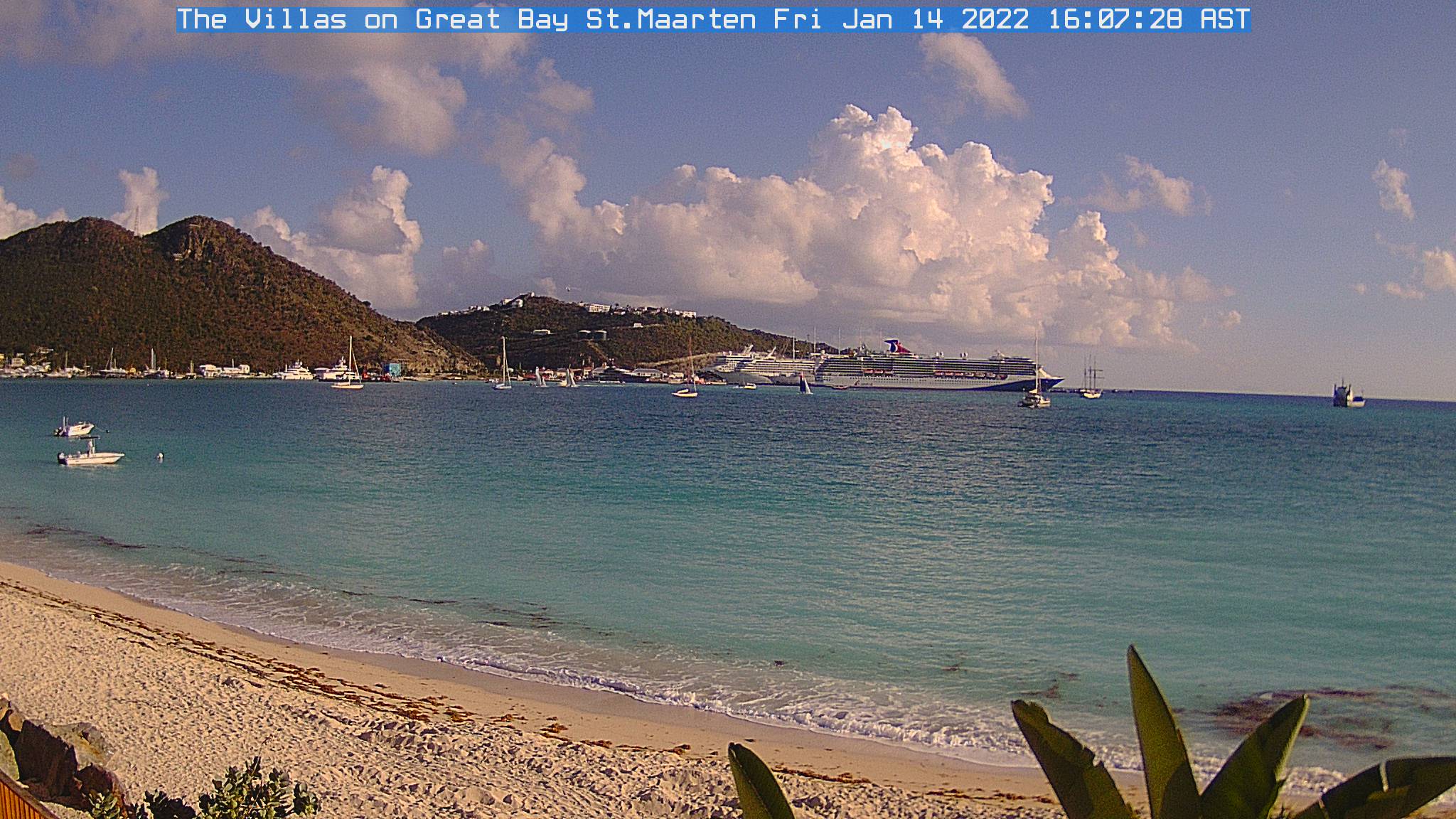
Re: ATL: Tropical Storm EARL - Discussion
Beautiful image right? This is a web cam from ST Maarten, one place that may be brushed by Earl. Lets follow this cam after sunday to see the effects from Earl as they occur. There are more cams at the first post of the Caribbean-CentralAmerica thread at U.S & Caribbean Weather forum.
0 likes
Visit the Caribbean-Central America Weather Thread where you can find at first post web cams,radars
and observations from Caribbean basin members Click Here
and observations from Caribbean basin members Click Here
-
Typhoon_Willie

- Category 5
- Posts: 1042
- Joined: Mon Jun 09, 2003 3:19 pm
- Location: Greenacres City, Florida
-
Gustywind
- Category 5
- Posts: 12334
- Joined: Mon Sep 03, 2007 7:29 am
- Location: Baie-Mahault, GUADELOUPE
Re: ATL: Tropical Storm EARL - Discussion
cycloneye wrote:Beautiful image right? This is a web cam from ST Maarten, one place that may be brushed by Earl. Lets follow this cam after sunday to see the effects from Earl as they occur. There are more cams at the Caribbean-CentralAmerica thread at U.S & Caribbean Weather forum.
Good catch Luis
0 likes
-
latitude_20

- Tropical Storm

- Posts: 196
- Joined: Wed Jun 30, 2010 6:46 am
- Location: Tulum, Mexico
- Contact:
Re: ATL: Tropical Storm EARL - Discussion
Looks to be holding to a very steady westerly track.
0 likes

More and more likely this does hit the NE Caribbean from the looks of things, not gaining any latitude at all today and if anything may have slightly shaved off some latitude.
This will probably be good news for the East coast though and bad news for the islands, because this is a highly likely to recurve system maybe like Luis was...(pray it don't get that strong!) and if that was to occur future Fiona would instead of being a threat to the east coast/Florida probably skirt away...
The fact that its moving so quickly to the west greatly worries me becuase it suggests the steering pattern is strong still...need it to weaken pronto really...
0 likes
Personal Forecast Disclaimer:
The posts in this forum are NOT official forecast and should not be used as such. They are just the opinion of the poster and may or may not be backed by sound meteorological data. They are NOT endorsed by any professional institution or storm2k.org. For official information, please refer to the NHC and NWS products
The posts in this forum are NOT official forecast and should not be used as such. They are just the opinion of the poster and may or may not be backed by sound meteorological data. They are NOT endorsed by any professional institution or storm2k.org. For official information, please refer to the NHC and NWS products
Who is online
Users browsing this forum: No registered users and 51 guests