ATL: Ex-Tropical Storm FIONA - Discussion
Moderator: S2k Moderators

Re: ATL: Tropical Storm FIONA - Discussion
Looks like it's going to be a pleasant and quiet Labor Day weekend getaway along the GOM coast. No threats ~ stay safe along the E. Coast.
0 likes
-
Dean4Storms
- S2K Supporter

- Posts: 6358
- Age: 63
- Joined: Sun Aug 31, 2003 1:01 pm
- Location: Miramar Bch. FL
-
allicat1214
- Tropical Low

- Posts: 29
- Joined: Tue Sep 20, 2005 3:48 pm
- Location: NOLA metro area
Re: ATL: Tropical Storm FIONA - Discussion
gatorcane wrote:[*]SouthFLTropics wrote:That's an awfully wide five day cone and once again shows Fiona slamming on the brakes...
That tells me one thing...NHC is WAY unsure about this puppy right now...
SFT
I totally agree with that. Some of the models tonight are bending it w or wsw At the end so will be interesting what the trends are for the 00z globals.

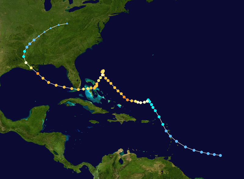
That's similar to what Hurricane Betsy did in 1965... I call it the Betsy loop.
http://upload.wikimedia.org/wikipedia/commons/thumb/2/20/Betsy_1965_track.png/800px-Betsy_1965_track.png
0 likes
-
SouthFLTropics

- Category 5

- Posts: 4258
- Age: 50
- Joined: Thu Aug 14, 2003 8:04 am
- Location: Port St. Lucie, Florida
Re: ATL: Tropical Storm FIONA - Discussion
fci wrote:SouthFLTropics wrote:That's an awfully wide five day cone and once again shows Fiona slamming on the brakes...
That tells me one thing...NHC is WAY unsure about this puppy right now...
SFT
I don't see anything wild about it.
A slow down to almost a stall Friday/Saturday.
We've seen loops and meanders before and this is still pretty strightforward for 5 days.
Beyond that , may be wild....
Please note that I said WIDE...not WILD!
SFT
0 likes
Fourth Generation Florida Native
Personal Storm History: David 79, Andrew 92, Erin 95, Floyd 99, Irene 99, Frances 04, Jeanne 04, Wilma 05, Matthew 16, Irma 17, Ian 22, Nicole 22, Milton 24
Personal Storm History: David 79, Andrew 92, Erin 95, Floyd 99, Irene 99, Frances 04, Jeanne 04, Wilma 05, Matthew 16, Irma 17, Ian 22, Nicole 22, Milton 24


Here's the 200mb at H+84 from 00Z Nam...NHC alluded to possible NE winds in the upper levels resulting in the ECMWF left bias. This would also expalin bamD sw movement as its deep...So if fiona manages to ramp up the next 24 or so then in all liklihood an ecm solution might be more plausible...well see...
200 mb at H+84
http://www.nco.ncep.noaa.gov/pmb/nwprod ... 0_084l.gif
200 mb at H+84
http://www.nco.ncep.noaa.gov/pmb/nwprod ... 0_084l.gif
0 likes

Re: ATL: Tropical Storm FIONA - Discussion
SouthFLTropics wrote:fci wrote:SouthFLTropics wrote:That's an awfully wide five day cone and once again shows Fiona slamming on the brakes...
That tells me one thing...NHC is WAY unsure about this puppy right now...
SFT
I don't see anything wild about it.
A slow down to almost a stall Friday/Saturday.
We've seen loops and meanders before and this is still pretty strightforward for 5 days.
Beyond that , may be wild....
Please note that I said WIDE...not WILD!
SFT
Oops, my bad, LOL
I will delete the original.
I think I am reading too many posts that I am getting blurred....

0 likes
-
SouthFLTropics
- Category 5
- Posts: 4258
- Age: 50
- Joined: Thu Aug 14, 2003 8:04 am
- Location: Port St. Lucie, Florida
Re: ATL: Tropical Storm FIONA - Discussion
I don't see anything wild about it.
A slow down to almost a stall Friday/Saturday.
We've seen loops and meanders before and this is still pretty strightforward for 5 days.
Beyond that , may be wild....[/quote]
Please note that I said WIDE...not WILD!
SFT[/quote]
Oops, my bad, LOL
I will delete the original.
I think I am reading too many posts that I am getting blurred....[/quote]
No worries my friend...It's all good...
A slow down to almost a stall Friday/Saturday.
We've seen loops and meanders before and this is still pretty strightforward for 5 days.
Beyond that , may be wild....[/quote]
Please note that I said WIDE...not WILD!
SFT[/quote]
Oops, my bad, LOL
I will delete the original.
I think I am reading too many posts that I am getting blurred....
[/quote]No worries my friend...It's all good...
Last edited by SouthFLTropics on Mon Aug 30, 2010 10:36 pm, edited 1 time in total.
0 likes
Fourth Generation Florida Native
Personal Storm History: David 79, Andrew 92, Erin 95, Floyd 99, Irene 99, Frances 04, Jeanne 04, Wilma 05, Matthew 16, Irma 17, Ian 22, Nicole 22, Milton 24
Personal Storm History: David 79, Andrew 92, Erin 95, Floyd 99, Irene 99, Frances 04, Jeanne 04, Wilma 05, Matthew 16, Irma 17, Ian 22, Nicole 22, Milton 24


Re: ATL: Tropical Storm FIONA - Discussion
Fiona and guest...
(also notice Earl north of PR - impressive!)
-

(also notice Earl north of PR - impressive!)
-
0 likes
-
gatorcane

- S2K Supporter
- Posts: 23708
- Age: 48
- Joined: Sun Mar 13, 2005 3:54 pm
- Location: Boca Raton, FL
Re:
Vortex wrote:Here's the 200mb at H+84 from 00Z Nam...NHC alluded to possible NE winds in the upper levels resulting in the ECMWF left bias. This would also expalin bamD sw movement as its deep...So if fiona manages to ramp up the next 24 or so then in all liklihood an ecm solution might be more plausible...well see...
200 mb at H+84
http://www.nco.ncep.noaa.gov/pmb/nwprod ... 0_084l.gif
Could be similar to what hannas outflow did to Ike? So in this case stronger would mean more west.
0 likes
-
WeatherGuesser
- Category 5
- Posts: 2672
- Joined: Tue Jun 29, 2010 6:46 am
Re:
WeatherGuesser wrote:What happened to all the doom and gloom models showing this coming across central FL as a 4 or 5?
The models were all over the place when she wasn't developed yet. Things should start becoming more clear in the upcoming days hopefully.
0 likes

-
WeatherGuesser
- Category 5
- Posts: 2672
- Joined: Tue Jun 29, 2010 6:46 am
-
Brent
- S2K Supporter
- Posts: 38765
- Age: 37
- Joined: Sun May 16, 2004 10:30 pm
- Location: Tulsa Oklahoma
- Contact:
Re: ATL: Tropical Storm FIONA - Discussion
Whoops, slight problem for poor little Fiona.

0 likes
#neversummer
If Fiona is closing in so fast on Earl, wouldn't it "take the path of least resistence" and follow in Earl's wake (get picked up by the same trough as Earl?)?
Of course, with Earl slowly chugging along and Fiona booking it, the NHC could be seeing that Fiona gets picked up by the first trough (around the Great Lakes yesterday), and Earl gets picked up by the second trough...
Of course, with Earl slowly chugging along and Fiona booking it, the NHC could be seeing that Fiona gets picked up by the first trough (around the Great Lakes yesterday), and Earl gets picked up by the second trough...
0 likes
-
dexterlabio
- Category 5
- Posts: 3511
- Joined: Sat Oct 24, 2009 11:50 pm
Re: ATL: Tropical Storm FIONA - Discussion
so no more "doomsday" forecast with fiona...at least for now? It could be that the agencies are in doubt whether fiona can grow big like danielle and earl.
0 likes
Personal Forecast Disclaimer:
The posts in this forum are NOT official forecast and should not be used as such. They are just the opinion of the poster and may or may not be backed by sound meteorological data. They are NOT endorsed by any professional institution or storm2k.org. For official information, please refer to the NHC and NWS products.
The posts in this forum are NOT official forecast and should not be used as such. They are just the opinion of the poster and may or may not be backed by sound meteorological data. They are NOT endorsed by any professional institution or storm2k.org. For official information, please refer to the NHC and NWS products.


Who is online
Users browsing this forum: No registered users and 58 guests