ATL: GASTON - Models
Moderator: S2k Moderators
-
lonelymike
- S2K Supporter

- Posts: 634
- Joined: Sat Jul 26, 2008 10:12 am
- Location: walton county fla
Re: ATL: Invest 98L - Models
So I'm supposed to believe a wave that is now moving WNW is supposed to be south of Key West in 2 weeks? BALDERDASH! 
0 likes
GO SEMINOLES
-
Ivanhater

- Storm2k Moderator

- Posts: 11221
- Age: 39
- Joined: Fri Jul 01, 2005 8:25 am
- Location: Pensacola
Re: ATL: Invest 98L - Models
lonelymike wrote:So I'm supposed to believe a wave that is now moving WNW is supposed to be south of Key West in 2 weeks? BALDERDASH!
Well you don't have to believe it, but it comes from somewhere. Best guess is 98L given location and analyzing the 850 vorticity and accompanying wind shift.
0 likes
Michael

Re: ATL: Invest 98L - Models
How long before someone calls this a fish or a recurve?  Those two words have been used so much lately.
0 likes
-
ColinDelia

- S2K Supporter
- Posts: 918
- Joined: Mon Aug 29, 2005 5:52 am
- Location: The Beach, FL
-
ColinDelia
- S2K Supporter
- Posts: 918
- Joined: Mon Aug 29, 2005 5:52 am
- Location: The Beach, FL
Re: ATL: Invest 98L - Models
sunnyday wrote:How long before someone calls this a fish or a recurve?
Long before it either forms or dissipates for good. lol
0 likes
-
cycloneye

- Admin

- Posts: 149583
- Age: 69
- Joined: Thu Oct 10, 2002 10:54 am
- Location: San Juan, Puerto Rico
Re: ATL: Invest 98L - Models
00z Tropical Models

Code: Select all
WHXX01 KWBC 010048
CHGHUR
TROPICAL CYCLONE GUIDANCE MESSAGE
NWS TPC/NATIONAL HURRICANE CENTER MIAMI FL
0048 UTC WED SEP 1 2010

DISCLAIMER...NUMERICAL MODELS ARE SUBJECT TO LARGE ERRORS.
PLEASE REFER TO NHC OFFICIAL FORECASTS FOR TROPICAL CYCLONE
AND SUBTROPICAL CYCLONE INFORMATION.

ATLANTIC OBJECTIVE AIDS FOR

DISTURBANCE INVEST (AL982010) 20100901 0000 UTC

        ...00 HRS...   ...12 HRS...   ...24 HRS. ..   ...36 HRS...
        100901  0000   100901  1200   100902  0000   100902  1200

         LAT    LON     LAT    LON     LAT    LON     LAT    LON
BAMS    12.2N  32.1W   12.7N  34.7W   13.2N  36.9W   13.4N  39.1W
BAMD    12.2N  32.1W   12.8N  34.3W   13.6N  36.1W   14.4N  37.6W
BAMM    12.2N  32.1W   12.8N  34.5W   13.3N  36.5W   13.8N  38.2W
LBAR    12.2N  32.1W   12.9N  34.6W   13.6N  37.2W   14.3N  39.5W
SHIP        25KTS          28KTS          33KTS          38KTS
DSHP        25KTS          28KTS          33KTS          38KTS

        ...48 HRS...   ...72 HRS...   ...96 HRS. ..   ..120 HRS...
        100903  0000   100904  0000   100905  0000   100906  0000

         LAT    LON     LAT    LON     LAT    LON     LAT    LON
BAMS    13.7N  41.1W   14.3N  45.2W   15.3N  49.7W   16.5N  55.0W
BAMD    15.2N  38.8W   17.2N  41.9W   19.6N  45.2W   20.9N  48.2W
BAMM    14.2N  39.7W   15.5N  43.1W   17.1N  46.9W   18.3N  51.4W
LBAR    15.1N  41.5W   17.7N  45.3W   22.4N  48.0W   25.9N  48.3W
SHIP        41KTS          46KTS          49KTS          51KTS
DSHP        41KTS          46KTS          49KTS          51KTS

         ...INITIAL CONDITIONS...
LATCUR =  12.2N LONCUR =  32.1W DIRCUR = 290DEG SPDCUR =  14KT
LATM12 =  11.2N LONM12 =  29.6W DIRM12 = 299DEG SPDM12 =  16KT
LATM24 =  10.0N LONM24 =  26.5W
WNDCUR =   25KT RMAXWD =   45NM WNDM12 =   25KT
CENPRS = 1008MB OUTPRS = 1009MB OUTRAD =  180NM SDEPTH =   S
RD34NE =    0NM RD34SE =    0NM RD34SW =    0NM RD34NW =   0NM
0 likes
Visit the Caribbean-Central America Weather Thread where you can find at first post web cams,radars
and observations from Caribbean basin members Click Here
and observations from Caribbean basin members Click Here

-
Blown Away

- S2K Supporter
- Posts: 10253
- Joined: Wed May 26, 2004 6:17 am
Re: ATL: Invest 98L - Models
Ivanhater wrote:That is 98L in the long range GFS by the Florida Keys
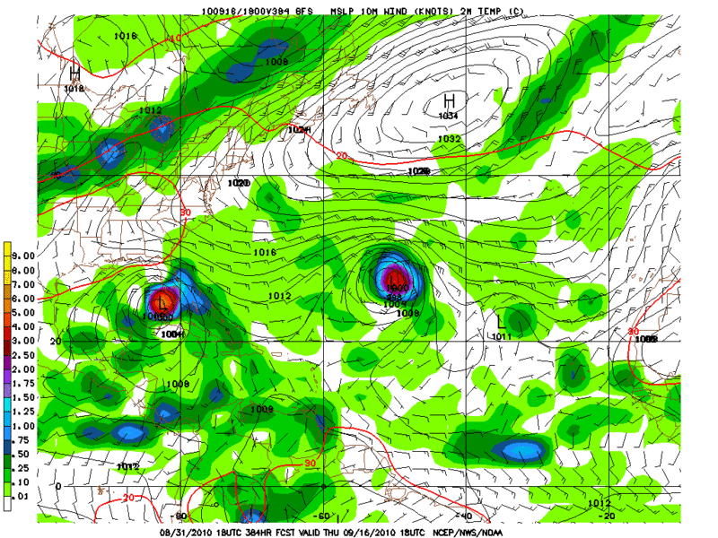
Are you sure that is 98L in th Keys? 98L is already past 30W and it seems hard to believe it will take 384 hours to make it to the Keys?
0 likes
Hurricane Eye Experience: David 79, Irene 99, Frances 04, Jeanne 04, Wilma 05… Hurricane Brush Experience: Andrew 92, Erin 95, Floyd 99, Matthew 16, Irma 17, Ian 22, Nicole 22…
-
RachelAnna

- Tropical Storm

- Posts: 106
- Joined: Mon Jun 28, 2010 10:38 pm
- Location: Cypress, Texas
Re: ATL: Invest 98L - Models
So considering how far out it is and that not all models are picking up on it, are our local experts thinking this is more likely to develop than not? I know the NHC has given it a 20% chance of developing in the next 48, but what do you think after that?
0 likes
-
Ivanhater
- Storm2k Moderator
- Posts: 11221
- Age: 39
- Joined: Fri Jul 01, 2005 8:25 am
- Location: Pensacola
Re: ATL: Invest 98L - Models
Blownaway, by 168 hours the system in the Keys comes from the weak vorticity in the extreme Southeastern Caribbean at 168 hours
It takes 9 days just to get through the Caribbean all the way to the keys, so when you trace it back before 168 hours by vort and wind shift to the current position it v adds up. However, there really isn't any need to over analyze the 18z GFS long range that will certainly change in future runs.

It takes 9 days just to get through the Caribbean all the way to the keys, so when you trace it back before 168 hours by vort and wind shift to the current position it v adds up. However, there really isn't any need to over analyze the 18z GFS long range that will certainly change in future runs.
0 likes
Michael
-
Blown Away
- S2K Supporter
- Posts: 10253
- Joined: Wed May 26, 2004 6:17 am
Re: ATL: Invest 98L - Models
RachelAnna wrote:So considering how far out it is and that not all models are picking up on it, are our local experts thinking this is more likely to develop than not? I know the NHC has given it a 20% chance of developing in the next 48, but what do you think after that?
The system keeps improving so I got to think this is Gaston in the making. It has model support and it's peak season. This system seems to have a better chance to get farther west.
0 likes
Hurricane Eye Experience: David 79, Irene 99, Frances 04, Jeanne 04, Wilma 05… Hurricane Brush Experience: Andrew 92, Erin 95, Floyd 99, Matthew 16, Irma 17, Ian 22, Nicole 22…
-
gatorcane

- S2K Supporter
- Posts: 23708
- Age: 48
- Joined: Sun Mar 13, 2005 3:54 pm
- Location: Boca Raton, FL
Right now model support just isn't that great on this system. The GFDL and HWRF barely keep it a low for the next 5 days. The GFS and ECMWF show nothing during this timeframe either. The CMC develops it but it is the CMC -- it develops about any low out there it seems.
That said, the structure looks good and there is cyclonic turning evident but development is going to be a long process with this one in my opinion, if it develops it at all. Main reason is the dry air. I already see evidence that dry air is slowly eating away at it looking at the SAT loops tonight. I need to see at least the ECMWF or GFS on board or else I am not going to be bullish on development.
As for the long-range models out there that I have seen posted in this thread, well won't even comment because we all know that is so far out there and has just about 0% chance of verifying.
0 likes
-
AtlanticWind

- S2K Supporter
- Posts: 1898
- Age: 67
- Joined: Sun Aug 08, 2004 9:57 pm
- Location: Plantation,Fla
Re:
[quote="gatorcane"]Right now model support just isn't that great on this system. The GFDL and HWRF barely keep it a low for the next 5 days. The GFS and ECMWF show nothing during this timeframe either. The CMC develops it but it is the CMC -- it develops about any low out there it seems.
That said, the structure looks good and there is cyclonic turning evident but development is going to be a long process with this one in my opinion, if it develops it at all. Main reason is the dry air. I already see evidence that dry air is slowly eating away at it looking at the SAT loops tonight. I need to see at least the ECMWF or GFS on board or else I am not going to be bullish on development.
As for the long-range models out there that I have seen posted in this thread, well won't even comment because we all know that is so far out there and has just about 0% chance of verifying.[
I dont see the dry air as a factor at all right now, seems to have a good moisture envelope . models should start to pick up on this over the next few cycles.
0 likes
Re: ATL: Invest 98L - Models
Something that lays low might be the only type of system that makes it past the recurve pattern.
This is the type of year where everyone watches Cape Verde and a sleeper creeps up out of the Caribbean.
This is the type of year where everyone watches Cape Verde and a sleeper creeps up out of the Caribbean.
Last edited by Sanibel on Tue Aug 31, 2010 10:14 pm, edited 1 time in total.
0 likes
-
lonelymike
- S2K Supporter
- Posts: 634
- Joined: Sat Jul 26, 2008 10:12 am
- Location: walton county fla
Re: ATL: Invest 98L - Models
Hard to see the model tracks verifying if its still moving WNW as the Xtrap indicates. But then again who knows. Ships doesn't do much with it.
0 likes
GO SEMINOLES
-
Ivanhater
- Storm2k Moderator
- Posts: 11221
- Age: 39
- Joined: Fri Jul 01, 2005 8:25 am
- Location: Pensacola
Re: ATL: Invest 98L - Models
lonelymike wrote:Hard to see the model tracks verifying if its still moving WNW as the Xtrap indicates. But then again who knows. Ships doesn't do much with it.
SHIPS makes this Tropical storm Gaston at 60 mph.
This has the attention of the NHC with them bumping up to 20 percent and declaring an invest. Structure has improved markedly over the day so those are the pluses.
In the short term, model support is minimal so I'm weary. However, enough pluses in my book to continue thorough analysis.
0 likes
Michael
-
hurricaneCW
- Category 5

- Posts: 1799
- Joined: Wed Mar 03, 2010 6:20 am
- Location: Toms River, NJ
Re: ATL: Invest 98L - Models
Models aren't perfect. Just because they don't show much now, doesn't mean we won't get a system. Remember when gfs showed a 1007 mb low with either Felix or Dean in 2007 when it was a Cat 5.
0 likes

Re:
gatorcane wrote:Right now model support just isn't that great on this system. The GFDL and HWRF barely keep it a low for the next 5 days. The GFS and ECMWF show nothing during this timeframe either. The CMC develops it but it is the CMC -- it develops about any low out there it seems.
That said, the structure looks good and there is cyclonic turning evident but development is going to be a long process with this one in my opinion, if it develops it at all. Main reason is the dry air. I already see evidence that dry air is slowly eating away at it looking at the SAT loops tonight. I need to see at least the ECMWF or GFS on board or else I am not going to be bullish on development.
As for the long-range models out there that I have seen posted in this thread, well won't even comment because we all know that is so far out there and has just about 0% chance of verifying.
Dee and Earl both had dry air to their north....didnt stop them from developing..
BTW- the CMC has outperformed the EURO for in the short range. It been tweaked from last year where it would spin up everything. This year has not been the case.
0 likes
Re: ATL: Invest 98L - Models
Ivanhater wrote:lonelymike wrote:Hard to see the model tracks verifying if its still moving WNW as the Xtrap indicates. But then again who knows. Ships doesn't do much with it.
SHIPS makes this Tropical storm Gaston at 60 mph.
This has the attention of the NHC with them bumping up to 20 percent and declaring an invest. Structure has improved markedly over the day so those are the pluses.
In the short term, model support is minimal so I'm weary. However, enough pluses in my book to continue thorough analysis.
agree.....the CMC always seems to find the spot of development way before the GFS IMO....GFS has been horrible this year...that said, models are slowly coming on board....
0 likes
Who is online
Users browsing this forum: No registered users and 45 guests