ATL: Ex-Tropical Storm HERMINE - Discussion

Moderator: S2k Moderators

Message
Author
Aric Dunn
Category 5
Category 5
Posts: 21238
Age: 42
Joined: Sun Sep 19, 2004 9:58 pm
Location: Ready for the Chase.
Contact:

Re: ATL: Tropical Storm HERMINE - Discussion

#401 Postby Aric Dunn » Mon Sep 06, 2010 3:05 pm

South Texas Storms wrote:does anyone else see a more recent northerly movement on the radar? or maybe ive just been looking at it too long...


well radar can be misleading. I am still plotting position estimates and from recon there is slight wobble. but over all motion is still more NW then NNW. more time is needed if it is more of short term motion or a wobble.
0 likes   
Note: If I make a post that is brief. Please refer back to previous posts for the analysis or reasoning. I do not re-write/qoute what my initial post said each time.
If there is nothing before... then just ask :)

Space & Atmospheric Physicist, Embry-Riddle Aeronautical University,
I believe the sky is falling...

bohaiboy
Tropical Depression
Tropical Depression
Posts: 86
Joined: Sat Aug 09, 2008 11:20 am

Re: ATL: Tropical Storm HERMINE - Discussion

#402 Postby bohaiboy » Mon Sep 06, 2010 3:10 pm

Not sure if related, bu we had a band of strong TS move thru hereSpring TX just N of H Town). My Davis gauge indicated 5.76" rain per hr.
0 likes   
TW in Texas Hill Country :flag:

Aric Dunn
Category 5
Category 5
Posts: 21238
Age: 42
Joined: Sun Sep 19, 2004 9:58 pm
Location: Ready for the Chase.
Contact:

#403 Postby Aric Dunn » Mon Sep 06, 2010 3:14 pm

Looking at radar from the first pass to the one coming up. I imagine pressure has fallen some.
0 likes   
Note: If I make a post that is brief. Please refer back to previous posts for the analysis or reasoning. I do not re-write/qoute what my initial post said each time.
If there is nothing before... then just ask :)

Space & Atmospheric Physicist, Embry-Riddle Aeronautical University,
I believe the sky is falling...

User avatar
jasons2k
Storm2k Executive
Storm2k Executive
Posts: 8245
Age: 51
Joined: Wed Jul 06, 2005 12:32 pm
Location: The Woodlands, TX

#404 Postby jasons2k » Mon Sep 06, 2010 3:29 pm

Image
0 likes   

User avatar
MGC
S2K Supporter
S2K Supporter
Posts: 5899
Joined: Sun Mar 23, 2003 9:05 pm
Location: Pass Christian MS, or what is left.

Re: ATL: Tropical Storm HERMINE - Discussion

#405 Postby MGC » Mon Sep 06, 2010 3:33 pm

Hermine is developing an excellent radar presentation with banding evident and an very evident eye forming. The storm should make hurricane intensity prior to landfall....also looks to be moving a bit more to the north......MGC
0 likes   

Aric Dunn
Category 5
Category 5
Posts: 21238
Age: 42
Joined: Sun Sep 19, 2004 9:58 pm
Location: Ready for the Chase.
Contact:

Re:

#406 Postby Aric Dunn » Mon Sep 06, 2010 3:33 pm

Aric Dunn wrote:Looking at radar from the first pass to the one coming up. I imagine pressure has fallen some.


recon found about 992mb. down from 995. also it has moved little since the last pass mostly because of the convection rotating around. should soon start moving NNW again.
0 likes   
Note: If I make a post that is brief. Please refer back to previous posts for the analysis or reasoning. I do not re-write/qoute what my initial post said each time.
If there is nothing before... then just ask :)

Space & Atmospheric Physicist, Embry-Riddle Aeronautical University,
I believe the sky is falling...

User avatar
Buck
S2K Supporter
S2K Supporter
Posts: 1173
Joined: Fri Sep 10, 2004 12:04 pm
Location: Atlanta, GA

Re: ATL: Tropical Storm HERMINE - Discussion

#407 Postby Buck » Mon Sep 06, 2010 3:35 pm

Very impressive radar presentation. Reminds me of her older cousins Humberto and Lorenzo.
0 likes   

User avatar
srainhoutx
S2K Supporter
S2K Supporter
Posts: 6919
Age: 67
Joined: Sun Jan 14, 2007 11:34 am
Location: Haywood County, NC
Contact:

Re: ATL: Tropical Storm HERMINE - Discussion

#408 Postby srainhoutx » Mon Sep 06, 2010 3:35 pm

From Nesdis...

SATELLITE PRECIPITATION ESTIMATES..DATE/TIME 09/06/10 1946Z
SATELLITE ANALYSIS BRANCH/NESDIS---NPPU---TEL.301-763-8678
LATEST DATA USED: GOES-13 1930Z KUSSELSON
.
LOCATION...S TEXAS...
.
ATTN WFOS...HGX...CRP...BRO...
ATTN RFCS...WGRFC...
.
EVENT...TS HERMINE RAINFALL...
.
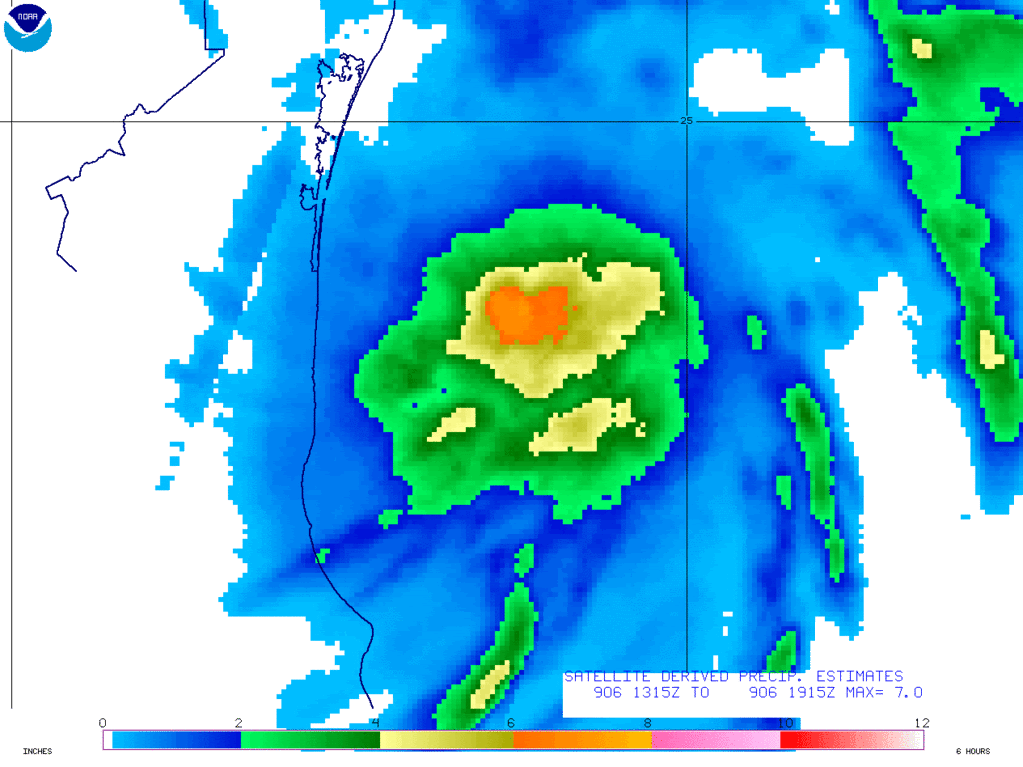
SATELLITE ANALYSIS AND TRENDS...VIS SATELLITE IMAGE AT 1745Z PUTTING
CENTER OF HERMINE NEAR 24N/96.7W AT 1745Z AND VIS THRU 1930Z MATCHING
RADAR CENTER CLOSE TO 24.2N/96.7W. IN ANY CASE SIGNIFICANT RAINS FROM
INNER CORE OF HERMINE STILL ABOUT 117 MILES FROM BROWNSVILLE. MOST
SIGNIFICANT OUTER BANDS ON NW SIDE FOR THE TIME WILL GO INTO NE MEXICO
SOUTH OF SOUTH TEXAS. ONLY A WEAK NARROW BAND HEADING NORTH TO AFFECT S
TEXAS AND NEAR THE COAST AND JUST INLAND OVER THE NEXT 3HRS. SATELLITE
6HR RAIN ESTIMATE MAX THRU 1915Z WAS CLOSE TO 7" NEAR 23.8N/96.2W...SEE
ESTIMATE GRAPHIC ON HOME PAGE SHORTLY AT ADDRESS BELOW...
WILL CONTINUE TO MONITOR AND SEND MESSAGES EVERY 3HRS WHILE HERMANE
HEADS TOWARD NE MEXICO AND SOUTH TEXAS.

Image
0 likes   
Carla/Alicia/Jerry(In The Eye)/Michelle/Charley/Ivan/Dennis/Katrina/Rita/Wilma/Ike/Harvey

Member: National Weather Association
Wx Infinity Forums
http://wxinfinity.com/index.php

Facebook.com/WeatherInfinity
Twitter @WeatherInfinity

CrazyC83
Professional-Met
Professional-Met
Posts: 34002
Joined: Tue Mar 07, 2006 11:57 pm
Location: Deep South, for the first time!

#409 Postby CrazyC83 » Mon Sep 06, 2010 3:36 pm

As for the intensity, I would keep it at 50 kt for now. The FL winds aren't that strong but there have been SFMR as high as 62 kt (but that was in a strong rainband so likely an overestimate).
0 likes   

supercane
S2K Supporter
S2K Supporter
Posts: 2858
Joined: Wed Sep 16, 2009 8:27 pm

#410 Postby supercane » Mon Sep 06, 2010 3:36 pm

Latest VDM:
000
URNT12 KNHC 062033
VORTEX DATA MESSAGE AL102010
A. 06/20:24:10Z
B. 24 deg 26 min N
096 deg 53 min W
C. 850 mb 1358 m
D. 45 kt
E. 129 deg 30 nm
F. 179 deg 49 kt
G. 129 deg 37 nm
H. EXTRAP 992 mb
I. 17 C / 1528 m
J. 21 C / 1527 m
K. 18 C / NA
L. NA
M. NA
N. 12345 / 8
O. 0.02 / 1 nm
P. AF301 0210A HERMINE OB 08
MAX FL WIND 49 KT SE QUAD 20:11:40Z
SLP EXTRAP FROM 850 MB
;
0 likes   

Aric Dunn
Category 5
Category 5
Posts: 21238
Age: 42
Joined: Sun Sep 19, 2004 9:58 pm
Location: Ready for the Chase.
Contact:

Re: ATL: Tropical Storm HERMINE - Discussion

#411 Postby Aric Dunn » Mon Sep 06, 2010 3:37 pm

MGC wrote:Hermine is developing an excellent radar presentation with banding evident and an very evident eye forming. The storm should make hurricane intensity prior to landfall....also looks to be moving a bit more to the north......MGC

yeah Banding is becoming very well pronounced in all quads. the pressure will likely be pretty low for a hurricane. but given its rate of organization once the inner core becomes well defined it should strengthen pretty fast.
0 likes   
Note: If I make a post that is brief. Please refer back to previous posts for the analysis or reasoning. I do not re-write/qoute what my initial post said each time.
If there is nothing before... then just ask :)

Space & Atmospheric Physicist, Embry-Riddle Aeronautical University,
I believe the sky is falling...

Aric Dunn
Category 5
Category 5
Posts: 21238
Age: 42
Joined: Sun Sep 19, 2004 9:58 pm
Location: Ready for the Chase.
Contact:

#412 Postby Aric Dunn » Mon Sep 06, 2010 3:39 pm

ok yeah I read the position wrong from recon.. it has moved from the previous position.. took a jog to NNW
0 likes   
Note: If I make a post that is brief. Please refer back to previous posts for the analysis or reasoning. I do not re-write/qoute what my initial post said each time.
If there is nothing before... then just ask :)

Space & Atmospheric Physicist, Embry-Riddle Aeronautical University,
I believe the sky is falling...

User avatar
Buck
S2K Supporter
S2K Supporter
Posts: 1173
Joined: Fri Sep 10, 2004 12:04 pm
Location: Atlanta, GA

#413 Postby Buck » Mon Sep 06, 2010 3:43 pm

5pm has 60mph and 992mb.
0 likes   

supercane
S2K Supporter
S2K Supporter
Posts: 2858
Joined: Wed Sep 16, 2009 8:27 pm

#414 Postby supercane » Mon Sep 06, 2010 3:43 pm

00
WTNT35 KNHC 062037
TCPAT5
BULLETIN
TROPICAL STORM HERMINE ADVISORY NUMBER 4
NWS TPC/NATIONAL HURRICANE CENTER MIAMI FL AL102010
400 PM CDT MON SEP 06 2010

...HERMINE NEARING THE COAST...SHOULD MAKE LANDFALL TONIGHT...


SUMMARY OF 400 PM CDT...2100 UTC...INFORMATION
----------------------------------------------
LOCATION...24.5N 97.0W
ABOUT 70 MI...110 KM NE OF LA PESCA MEXICO
ABOUT 100 MI...165 KM SSE OF BROWNSVILLE TEXAS
MAXIMUM SUSTAINED WINDS...60 MPH...95 KM/HR
PRESENT MOVEMENT...NNW OR 330 DEGREES AT 15 MPH...24 KM/HR
MINIMUM CENTRAL PRESSURE...992 MB...29.29 INCHES

FORECAST POSITIONS AND MAX WINDS

INITIAL 06/2100Z 24.5N 97.0W 50 KT
12HR VT 07/0600Z 26.2N 98.3W 55 KT...INLAND
24HR VT 07/1800Z 28.5N 99.6W 30 KT...INLAND
36HR VT 08/0600Z 30.7N 100.4W 25 KT...INLAND
48HR VT 08/1800Z 33.0N 100.5W 20 KT...POST-TROP/REMNT LOW
72HR VT 09/1800Z 38.0N 98.5W 20 KT...POST-TROP/REMNT LOW
96HR VT 10/1800Z...DISSIPATED
0 likes   

CrazyC83
Professional-Met
Professional-Met
Posts: 34002
Joined: Tue Mar 07, 2006 11:57 pm
Location: Deep South, for the first time!

#415 Postby CrazyC83 » Mon Sep 06, 2010 3:44 pm

It seems this is a pretty shallow storm with not much wind at the mid-levels. The SFMR has been consistently well above the flight-level winds.
0 likes   

Aric Dunn
Category 5
Category 5
Posts: 21238
Age: 42
Joined: Sun Sep 19, 2004 9:58 pm
Location: Ready for the Chase.
Contact:

#416 Postby Aric Dunn » Mon Sep 06, 2010 3:46 pm

every frame of radar pointing at this making a run for hurricane very rapidly if the inner core can get going very soon. and it definately seems to wobbling closer to N than NNW now probably wont last but it does bring it ever so closer to brownsville..
Last edited by Aric Dunn on Mon Sep 06, 2010 3:48 pm, edited 1 time in total.
0 likes   
Note: If I make a post that is brief. Please refer back to previous posts for the analysis or reasoning. I do not re-write/qoute what my initial post said each time.
If there is nothing before... then just ask :)

Space & Atmospheric Physicist, Embry-Riddle Aeronautical University,
I believe the sky is falling...

User avatar
lester
S2K Supporter
S2K Supporter
Posts: 1305
Age: 36
Joined: Sat Aug 27, 2005 5:21 pm
Location: Washington, DC
Contact:

#417 Postby lester » Mon Sep 06, 2010 3:55 pm

Center tightening up on radar. Definitely making a run before landfall
0 likes   

User avatar
South Texas Storms
Professional-Met
Professional-Met
Posts: 4226
Joined: Thu Jun 24, 2010 12:28 am
Location: Houston, TX

Re: ATL: Tropical Storm HERMINE - Discussion

#418 Postby South Texas Storms » Mon Sep 06, 2010 3:56 pm

:uarrow:
agree. it will be close to hurricane strength at landfall imo. also looks to be back on the NNW motion.
0 likes   

User avatar
vbhoutex
Storm2k Executive
Storm2k Executive
Posts: 29112
Age: 73
Joined: Wed Oct 09, 2002 11:31 pm
Location: Cypress, TX
Contact:

Re:

#419 Postby vbhoutex » Mon Sep 06, 2010 4:00 pm

Aric Dunn wrote:every frame of radar pointing at this making a run for hurricane very rapidly if the inner core can get going very soon. and it definately seems to wobbling closer to N than NNW now probably wont last but it does bring it ever so closer to brownsville..

I've looked at a few different radars and I have to agree with you Aric. I am beginning to think that Hermine may come in just South of or possibly right over Brownsville. That is based only on radar I have looked at and nothing else. I also agree that the core is trying to consolidate more, but I am not sure it is going to make it to a really solid core. Hermine has gone a good deal further development wise than I originally thought she would so we shall see. Recon is in right now so we will know for sure soon enough. Glad they were able to task another plane quickly.
0 likes   
Skywarn, C.E.R.T.
Please click below to donate to STORM2K to help with the expenses of keeping the site going:
Image

Aric Dunn
Category 5
Category 5
Posts: 21238
Age: 42
Joined: Sun Sep 19, 2004 9:58 pm
Location: Ready for the Chase.
Contact:

Re: Re:

#420 Postby Aric Dunn » Mon Sep 06, 2010 4:05 pm

vbhoutex wrote:
Aric Dunn wrote:every frame of radar pointing at this making a run for hurricane very rapidly if the inner core can get going very soon. and it definately seems to wobbling closer to N than NNW now probably wont last but it does bring it ever so closer to brownsville..

I've looked at a few different radars and I have to agree with you Aric. I am beginning to think that Hermine may come in just South of or possibly right over Brownsville. That is based only on radar I have looked at and nothing else. I also agree that the core is trying to consolidate more, but I am not sure it is going to make it to a really solid core. Hermine has gone a good deal further development wise than I originally thought she would so we shall see. Recon is in right now so we will know for sure soon enough. Glad they were able to task another plane quickly.


yeah they really needed to get another plane out. yeah it does not have enough to time to become anymore than a minimal hurricane at best but its angle of approach could keep its intensity a little longer than normal since most of the circ will be over water as it passes brownsville. so if it becomes a hurricane brownsville could experience some of the strongest winds.
0 likes   
Note: If I make a post that is brief. Please refer back to previous posts for the analysis or reasoning. I do not re-write/qoute what my initial post said each time.
If there is nothing before... then just ask :)

Space & Atmospheric Physicist, Embry-Riddle Aeronautical University,
I believe the sky is falling...


Return to “2010”

Who is online

Users browsing this forum: No registered users and 2 guests