SE TX/SW LA weather: Much cooler and WET after Tuesday

U.S. & Caribbean Weather Discussions and Severe Weather Events

Moderator: S2k Moderators

Forum rules

The posts in this forum are NOT official forecast and should not be used as such. They are just the opinion of the poster and may or may not be backed by sound meteorological data. They are NOT endorsed by any professional institution or STORM2K.

Help Support Storm2K
Message
Author
User avatar
srainhoutx
S2K Supporter
S2K Supporter
Posts: 6919
Age: 67
Joined: Sun Jan 14, 2007 11:34 am
Location: Haywood County, NC
Contact:

Re: SE TX/SW LA weather: HOT!

#5021 Postby srainhoutx » Tue Sep 07, 2010 8:35 am

From Nesdis...

SATELLITE PRECIPITATION ESTIMATES..DATE/TIME 09/07/10 1134Z
SATELLITE ANALYSIS BRANCH/NESDIS---NPPU---TEL.301-763-8678
LATEST DATA USED: GOES-12: 1115Z DS
.
LOCATION...S/SE/CENTRAL TEXAS...
.
ATTN WFOS...HGX...FWD...CRP...EWX...BRO...SJT...
ATTN RFCS...WGRFC...
.
EVENT...HVY RAINS ASSCD WITH T.S. HERMINE
.
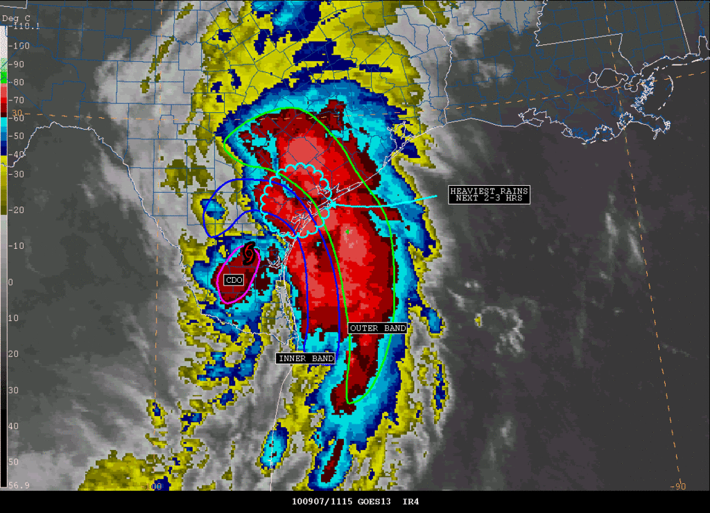
SATELLITE ANALYSIS AND TRENDS...CENTER OF T.S. HERMINE CAN BE SEEN VERY
CLEARLY IN RADAR IMAGERY OVER THE KLEBERG/JIM WELLS COUNTY BORDER AND
RECENTLY HAS STARTED TO TAKE ON A SLIGHTLY MORE NWRLY TRACK THAN THE NR
DUE N TRACK IT HAS BEEN ON MOST OF THE NIGHT. RICH MOISTURE CONTINUES
TO BE PUMPED NWWD FROM THE WRN GOM AND INTO THE SE TX COAST/S CENTRAL
REGION OF TX. AS HERMINE BEGINS TO TAKE ON MORE OF A NWRLY MOVEMENT PER
THE NHC FCST TRACK..THIS SHOULD ALLOW FOR ADDTL PRECIP TO LIFT NW TWDS
CENTRAL TX. NUMEROUS OVERSHOOTING TOPS HAVE BEEN NOTICEABLE IN THE VERY
COLD CNVTN OF THE OUTER BAND OF THIS STORM DURING THE LAST 2-3 HRS WITH
A FEW OCCASIONS WHERE CLOUD TOP TEMPS BREACHED THE -80C BARRIER.
.
GIVEN THE CENTER IS BEGINNING TO MOVE INLAND IT HAS APPEARED RECENTLY
THAT THE OUTER BAND HAS BEEN THE MAIN PRECIP PRODUCER..PROVIDING
COVERAGE OF MOD-HVY RAINFALL OVER A WIDE AREA OF THE TX COAST. ANOTHER
SMALL BAND IS BEGINNING TO SET UP THOUGH..JUST WITHIN THE LAST HR OR
SO..STRETCHING SSEWD FROM REFUGIO COUNTY. TORRENTIAL RAINFALL RATES
OF 2-3"/HR ARE LIKELY TO BE OCCURRING BENEATH THIS INNER BAND WHILE IN
GNRL ESTIMATED RATES OF 1-2"/HR ARE OCCURRING IN THE OUTER BAND(S) AS
CELLS COME ONSHORE. RATES ARE LIKELY LESSER INLAND BUT THE STRONG INFLOW
BEING WRAPPED INTO THE STATE WITH VWP'S INDICATING 30-40KTS OF 85H FLOW
WILL KEEP PUSHING MOISTURE/PRECIP FURTHER INLAND THROUGHOUT THE EARLY
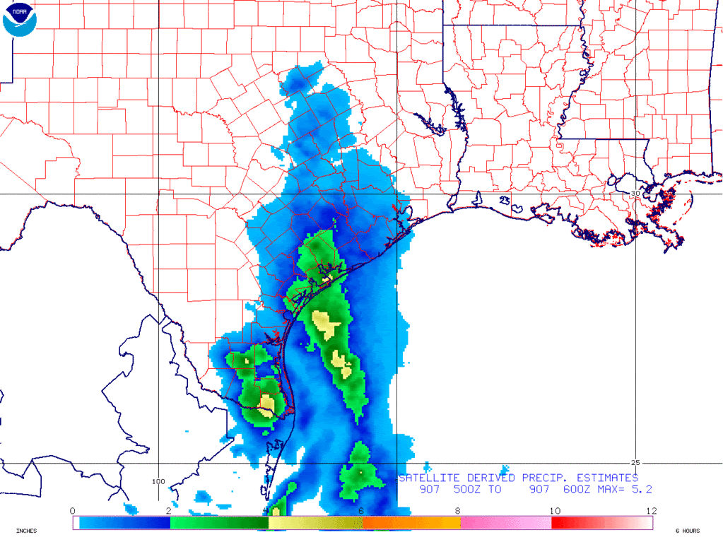
MORNING. 6 HR SATL ESTIMATES ENDING 11Z HAVE GIVEN MAX AMOUNTS OF 5.2"
JUST OFF THE COAST OF REFUGIO COUNTY WITH A NR 5" ESTIMATE OVER PART OF
CAMERON COUNTY AND 4.5" OF SE CALHOUN COUNTY.
.
PLEASE SEE WEB ADDRESS BELOW FOR ESTIMATE GRAPHIC AND GRAPHIC ANALYSIS.
.
SHORT TERM OUTLOOK VALID 1130-1430Z..HIGH CONFIDENCE IN SHORT TERM
OUTLOOK..SLIGHT SHIFT IN TRACK NOW OF THE CENTER APPEARS TO BE GOING A
BIT MORE NW NOW PULLING RICH MOISTURE INTO CENTRAL TX WITH IT. HIGHEST
CHC FOR HVY RAINFALL THREAT IN SHORT TERM REMAINS NR THE COAST THOUGH
WHERE HVY RAINS HAVE ALREADY OCCURRED AND RATES WILL BE HIGHEST.

Image

Image
0 likes   
Carla/Alicia/Jerry(In The Eye)/Michelle/Charley/Ivan/Dennis/Katrina/Rita/Wilma/Ike/Harvey

Member: National Weather Association
Wx Infinity Forums
http://wxinfinity.com/index.php

Facebook.com/WeatherInfinity
Twitter @WeatherInfinity

User avatar
srainhoutx
S2K Supporter
S2K Supporter
Posts: 6919
Age: 67
Joined: Sun Jan 14, 2007 11:34 am
Location: Haywood County, NC
Contact:

Re: SE TX/SW LA weather: HOT!

#5022 Postby srainhoutx » Tue Sep 07, 2010 9:36 am

BULLETIN - EAS ACTIVATION REQUESTED
TORNADO WARNING
NATIONAL WEATHER SERVICE HOUSTON/GALVESTON TX
928 AM CDT TUE SEP 7 2010

THE NATIONAL WEATHER SERVICE IN LEAGUE CITY HAS ISSUED A

* TORNADO WARNING FOR...
NORTHERN FORT BEND COUNTY IN SOUTHEAST TEXAS...
SOUTHERN WALLER COUNTY IN SOUTHEAST TEXAS...

* UNTIL 1000 AM CDT

* AT 925 AM CDT...NATIONAL WEATHER SERVICE DOPPLER RADAR INDICATED A
SEVERE THUNDERSTORM CAPABLE OF PRODUCING A TORNADO THIS TORNADO
WAS LOCATED NEAR FULSHEAR... MOVING NORTHWEST AT 35 MPH.

* LOCATIONS IN THE TORNADO WARNING INCLUDE BUT ARE NOT LIMITED TO
MONAVILLE...PRAIRIE VIEW...PINE ISLAND...PATTISON AND BROOKSHIRE.
0 likes   
Carla/Alicia/Jerry(In The Eye)/Michelle/Charley/Ivan/Dennis/Katrina/Rita/Wilma/Ike/Harvey

Member: National Weather Association
Wx Infinity Forums
http://wxinfinity.com/index.php

Facebook.com/WeatherInfinity
Twitter @WeatherInfinity

User avatar
vbhoutex
Storm2k Executive
Storm2k Executive
Posts: 29112
Age: 73
Joined: Wed Oct 09, 2002 11:31 pm
Location: Cypress, TX
Contact:

Re: SE TX/SW LA weather: HOT!

#5023 Postby vbhoutex » Tue Sep 07, 2010 9:45 am

Hmm, radar in that area is interesting. I guess I see what they are alluding to. Very quiet here considering how close that is to our area. Radar is telling the story. Many parts of S and W Houston are getting ready to have some fun(NOT) with the incoming rain bands. Looks like some very heavy rains moving in and there could be some training of these storms. Remember to "turn around don't drown" if you are caught in an area that is experiencing flooding. Guess I won't get too much yard work done today. :cheesy:
0 likes   
Skywarn, C.E.R.T.
Please click below to donate to STORM2K to help with the expenses of keeping the site going:
Image

User avatar
srainhoutx
S2K Supporter
S2K Supporter
Posts: 6919
Age: 67
Joined: Sun Jan 14, 2007 11:34 am
Location: Haywood County, NC
Contact:

Re: SE TX/SW LA weather: HOT!

#5024 Postby srainhoutx » Tue Sep 07, 2010 9:52 am

I missed this one while out running errands...

BULLETIN - EAS ACTIVATION REQUESTED
FLASH FLOOD WARNING
NATIONAL WEATHER SERVICE HOUSTON/GALVESTON TX
855 AM CDT TUE SEP 7 2010

THE NATIONAL WEATHER SERVICE IN LEAGUE CITY HAS ISSUED A

* FLASH FLOOD WARNING FOR...
COLORADO COUNTY IN SOUTHEAST TEXAS...
JACKSON COUNTY IN SOUTHEAST TEXAS...
MATAGORDA COUNTY IN SOUTHEAST TEXAS...
WHARTON COUNTY IN SOUTHEAST TEXAS...

* UNTIL NOON CDT

* AT 852 AM CDT...NATIONAL WEATHER SERVICE DOPPLER RADAR INDICATED
THAT FLASH FLOODING WAS LIKELY FROM WIDESPREAD MODERATE RAIN AND
EMBEDDED THUNDERSTORMS. THE EMBEDDED STORMS WILL PRODUCE LOCALLY
HEAVY RAIN WHICH WILL LIKELY CAUSE FLASH FLOODING IN THE WARNING
AREA. 3 TO 4 INCHES OF RAIN HAS ALREADY FALLEN OVER PARTS OF JACKSON
AND MATAGORDA COUNTIES AND 1 TO 3 INCHES OF RAIN HAS FALLEN OVER
PARTS OF COLORADO AND WHARTON COUNTIES. AN ADDITIONAL 2 TO 3 INCHES
OF RAIN IS EXPECTED THIS MORNING OVER PARTS OF THE WARNING AREA.

* LOCATIONS IN THE FLOOD WARNING INCLUDE BUT ARE NOT LIMITED TO
WADSWORTH...VANDERBILT...SOUTH TEXAS NUCLEAR PLANT...SHERIDAN...
SARGENT...ROCK ISLAND...PIERCE...NADA...MORALES...MIDFIELD...
MATAGORDA...LOUISE...LAKE TEXANA DAM...HUNGERFORD...GARWOOD...
FRELSBURG...EGYPT...DANEVANG...CORDELE...BLESSING...WHARTON...
WEIMAR...VAN VLECK...PALACIOS...MARKHAM...LA WARD...GANADO...EL
CAMPO...EDNA...EAGLE LAKE...COLUMBUS AND BOLING-IAGO.
0 likes   
Carla/Alicia/Jerry(In The Eye)/Michelle/Charley/Ivan/Dennis/Katrina/Rita/Wilma/Ike/Harvey

Member: National Weather Association
Wx Infinity Forums
http://wxinfinity.com/index.php

Facebook.com/WeatherInfinity
Twitter @WeatherInfinity

User avatar
srainhoutx
S2K Supporter
S2K Supporter
Posts: 6919
Age: 67
Joined: Sun Jan 14, 2007 11:34 am
Location: Haywood County, NC
Contact:

Re: SE TX/SW LA weather: HOT!

#5025 Postby srainhoutx » Tue Sep 07, 2010 10:07 am

BULLETIN - EAS ACTIVATION REQUESTED
TORNADO WARNING
NATIONAL WEATHER SERVICE HOUSTON/GALVESTON TX
1000 AM CDT TUE SEP 7 2010

THE NATIONAL WEATHER SERVICE IN LEAGUE CITY HAS ISSUED A

* TORNADO WARNING FOR...
NORTHWESTERN WALLER COUNTY IN SOUTHEAST TEXAS...
NORTHEASTERN WASHINGTON COUNTY IN SOUTHEAST TEXAS...

* UNTIL 1030 AM CDT

* AT 957 AM CDT...NATIONAL WEATHER SERVICE DOPPLER RADAR INDICATED A
SEVERE THUNDERSTORM CAPABLE OF PRODUCING A TORNADO THIS TORNADO
WAS LOCATED NEAR HEMPSTEAD... MOVING NORTHWEST AT 35 MPH.

* LOCATIONS IN THE TORNADO WARNING INCLUDE BUT ARE NOT LIMITED TO
WASHINGTON AND PINE ISLAND.
0 likes   
Carla/Alicia/Jerry(In The Eye)/Michelle/Charley/Ivan/Dennis/Katrina/Rita/Wilma/Ike/Harvey

Member: National Weather Association
Wx Infinity Forums
http://wxinfinity.com/index.php

Facebook.com/WeatherInfinity
Twitter @WeatherInfinity

User avatar
srainhoutx
S2K Supporter
S2K Supporter
Posts: 6919
Age: 67
Joined: Sun Jan 14, 2007 11:34 am
Location: Haywood County, NC
Contact:

Re: SE TX/SW LA weather: HOT!

#5026 Postby srainhoutx » Tue Sep 07, 2010 10:12 am

HGX expands Flood Watch...

FLOOD WATCH
NATIONAL WEATHER SERVICE HOUSTON/GALVESTON TX
1007 AM CDT TUE SEP 7 2010

TXZ195>199-080300-
/O.EXA.KHGX.FF.A.0005.000000T0000Z-100908T1200Z/
/00000.0.ER.000000T0000Z.000000T0000Z.000000T0000Z.OO/
BRAZOS-BURLESON-GRIMES-MONTGOMERY-WASHINGTON-
INCLUDING THE CITIES OF...BRENHAM...BRYAN...CALDWELL...
COLLEGE STATION...CONROE...LAKE SOMERVILLE...NAVASOTA...
THE WOODLANDS...WILLIS
1007 AM CDT TUE SEP 7 2010

...FLASH FLOOD WATCH IN EFFECT THROUGH WEDNESDAY MORNING...

THE NATIONAL WEATHER SERVICE IN HOUSTON/GALVESTON HAS EXPANDED
THE

* FLASH FLOOD WATCH TO INCLUDE A PORTION OF SOUTHEAST TEXAS...
INCLUDING THE FOLLOWING COUNTIES...BRAZOS...BURLESON...
GRIMES...MONTGOMERY AND WASHINGTON.

* THROUGH WEDNESDAY MORNING

* TROPICAL STORM HERMINE WILL CONTINUE TO MOVE NORTH INTO CENTRAL
TEXAS LATER THIS MORNING AND THEN INTO WEST CENTRAL TEXAS BY
EARLY WEDNESDAY. WIDESPREAD PRECIPITATION IS OCCURRING ACROSS
MOST OF THE WATCH AREA THIS MORNING ACROSS SOUTHEAST TEXAS AND
WILL EXPAND NORTHWARD THIS AFTERNOON AND CONTINUE INTO THE
EVENING HOURS. LOCALLY HEAVY RAIN AND TRAINING CELLS ARE LIKELY.
EXPECT WIDESPREAD 1 TO 3 INCH RAINFALL AMOUNTS THROUGH TONIGHT
WITH THE POTENTIAL FOR SOME AREAS TO EXPERIENCE 5 TO 10 INCHES
WHERE TRAINING PRECIPITATION OCCURS.
0 likes   
Carla/Alicia/Jerry(In The Eye)/Michelle/Charley/Ivan/Dennis/Katrina/Rita/Wilma/Ike/Harvey

Member: National Weather Association
Wx Infinity Forums
http://wxinfinity.com/index.php

Facebook.com/WeatherInfinity
Twitter @WeatherInfinity

User avatar
srainhoutx
S2K Supporter
S2K Supporter
Posts: 6919
Age: 67
Joined: Sun Jan 14, 2007 11:34 am
Location: Haywood County, NC
Contact:

Re: SE TX/SW LA weather: HOT!

#5027 Postby srainhoutx » Tue Sep 07, 2010 11:09 am

BULLETIN - EAS ACTIVATION REQUESTED
SEVERE THUNDERSTORM WARNING
NATIONAL WEATHER SERVICE HOUSTON/GALVESTON TX
1052 AM CDT TUE SEP 7 2010

THE NATIONAL WEATHER SERVICE IN LEAGUE CITY HAS ISSUED A

* SEVERE THUNDERSTORM WARNING FOR...
CENTRAL BRAZOS COUNTY IN SOUTHEAST TEXAS...
EASTERN BURLESON COUNTY IN SOUTHEAST TEXAS...

* UNTIL 1115 AM CDT

* AT 1049 AM CDT...NATIONAL WEATHER SERVICE DOPPLER RADAR INDICATED A
SEVERE THUNDERSTORM. THIS STORM WAS LOCATED 9 MILES SOUTH OF
COLLEGE STATION...AND MOVING NORTH AT 35 MPH.

* LOCATIONS IN THE SEVERE THUNDERSTORM WARNING INCLUDE BUT ARE NOT
LIMITED TO BRYAN.
0 likes   
Carla/Alicia/Jerry(In The Eye)/Michelle/Charley/Ivan/Dennis/Katrina/Rita/Wilma/Ike/Harvey

Member: National Weather Association
Wx Infinity Forums
http://wxinfinity.com/index.php

Facebook.com/WeatherInfinity
Twitter @WeatherInfinity

User avatar
jasons2k
Storm2k Executive
Storm2k Executive
Posts: 8245
Age: 51
Joined: Wed Jul 06, 2005 12:32 pm
Location: The Woodlands, TX

#5028 Postby jasons2k » Tue Sep 07, 2010 1:11 pm

Image
0 likes   

User avatar
JenBayles
Category 5
Category 5
Posts: 3461
Age: 62
Joined: Tue Aug 26, 2003 3:27 pm
Location: Houston, TX
Contact:

#5029 Postby JenBayles » Tue Sep 07, 2010 1:31 pm

Dodging the flood bullet so far here in Bear Creek with the worst rain just east of us. Standing right at 3" since yesterday. Anyone have any more personal flood reports from the Houston area?
0 likes   

User avatar
horselattitudesfarm
Category 1
Category 1
Posts: 315
Joined: Thu Jul 16, 2009 5:55 pm
Location: Asheville, NC (formerly from Dallas, TX)

Re: Re:

#5030 Postby horselattitudesfarm » Tue Sep 07, 2010 3:23 pm

CajunMama wrote:
horselattitudesfarm wrote:The rain you guys get is phenomenal to me! It is hard to fathom multi-inch rains like that. It usually takes us 4 or 5 rains to get up to an inch over the span of weeks up here.


Where is "here" for you? You can add your location to your profile (hint! hint!) and that way we'll know where "here" is :lol:


I'm currently in Dallas, Texas. I added it to my profile. Thanks for the hint 8-)
0 likes   

User avatar
jasons2k
Storm2k Executive
Storm2k Executive
Posts: 8245
Age: 51
Joined: Wed Jul 06, 2005 12:32 pm
Location: The Woodlands, TX

#5031 Postby jasons2k » Tue Sep 07, 2010 5:28 pm

I've had 2.75" here since yesterday morning.
0 likes   

Flyinman
S2K Supporter
S2K Supporter
Posts: 265
Joined: Thu Aug 16, 2007 3:03 pm
Location: The Woodlands, Texas

Re: SE TX/SW LA weather: HOT!

#5032 Postby Flyinman » Tue Sep 07, 2010 8:58 pm

I am now just over 3.25" since yesterday afternoon and still raining.
0 likes   

User avatar
horselattitudesfarm
Category 1
Category 1
Posts: 315
Joined: Thu Jul 16, 2009 5:55 pm
Location: Asheville, NC (formerly from Dallas, TX)

#5033 Postby horselattitudesfarm » Wed Sep 08, 2010 12:39 pm

OK, OK, I guess the weather gods are getting mad at me! 4" and counting just today so far! Thats what I get for complaining about not getting rain. I even found a couple of leaks in the house I didn't know about before.
0 likes   

User avatar
vbhoutex
Storm2k Executive
Storm2k Executive
Posts: 29112
Age: 73
Joined: Wed Oct 09, 2002 11:31 pm
Location: Cypress, TX
Contact:

Re:

#5034 Postby vbhoutex » Wed Sep 08, 2010 1:12 pm

horselattitudesfarm wrote:OK, OK, I guess the weather gods are getting mad at me! 4" and counting just today so far! Thats what I get for complaining about not getting rain. I even found a couple of leaks in the house I didn't know about hopefullybefore.

OOPS!!! That'll teach you! J/K I hope you don't have too man problems.
I had 3.18" the last two days so we are soggy, but we have had few problems from the rains here in the Houston metro area. Some heavy rains are progged for this afternoon. If they materialize hopefully they will be brief.
0 likes   
Skywarn, C.E.R.T.
Please click below to donate to STORM2K to help with the expenses of keeping the site going:
Image

CajunMama
Retired Staff
Retired Staff
Posts: 10791
Joined: Thu Feb 06, 2003 9:57 pm
Location: 30.22N, 92.05W Lafayette, LA

#5035 Postby CajunMama » Sat Sep 11, 2010 6:17 pm

There should be a law against afternoon football games in south louisiana. Our game started at 2:30 with most of the stadium in the sun. Bre, who was smart stayed home and watched it on tv, texted me and said the heat index on the field was 118F. We sit 13 rows above them with no portable air coolers so we weren't much cooler than that. There was no one left in the student section after halftime and the band left with 12 minutes to play. It's now shower time and this will probably be the best shower i've ever taken! :lol:
0 likes   

User avatar
jasons2k
Storm2k Executive
Storm2k Executive
Posts: 8245
Age: 51
Joined: Wed Jul 06, 2005 12:32 pm
Location: The Woodlands, TX

#5036 Postby jasons2k » Thu Sep 16, 2010 12:04 pm

Forgot to post, so add another .70" to my storm total from Hermine.

I got some pretty good pics of the first feeder band and one of these days I'll post them....been busy!!
0 likes   

User avatar
artist
Category 5
Category 5
Posts: 9792
Joined: Mon Jun 06, 2005 3:26 pm
Location: West Palm

#5037 Postby artist » Mon Sep 20, 2010 11:29 am

I've heard there is major flooding going on in Corpus Christi from the residual of Karl.
0 likes   

CajunMama
Retired Staff
Retired Staff
Posts: 10791
Joined: Thu Feb 06, 2003 9:57 pm
Location: 30.22N, 92.05W Lafayette, LA

#5038 Postby CajunMama » Fri Sep 24, 2010 9:40 am

Highs in the lower 80's and lows in the lower 60's early next week! YAY!
0 likes   

User avatar
southerngale
Retired Staff
Retired Staff
Posts: 27418
Joined: Thu Oct 10, 2002 1:27 am
Location: Southeast Texas (Beaumont area)

#5039 Postby southerngale » Fri Sep 24, 2010 11:11 am

I'm going to get some pool time in this weekend because the water will be a lot cooler by next weekend!
0 likes   
Please support Storm2k by making a donation today. It is greatly appreciated! Click here: Image

Image my Cowboys Image my RocketsImage my Astros

User avatar
Tireman4
S2K Supporter
S2K Supporter
Posts: 5853
Age: 59
Joined: Fri Jun 30, 2006 1:08 pm
Location: Humble, Texas
Contact:

Re:

#5040 Postby Tireman4 » Fri Sep 24, 2010 12:02 pm

southerngale wrote:I'm going to get some pool time in this weekend because the water will be a lot cooler by next weekend!


Do not forget to support our Cowboys Gale!!!!
0 likes   


Return to “USA & Caribbean Weather”

Who is online

Users browsing this forum: cstrunk and 12 guests