

ATL: IGOR - Ex Hurricane - Discussion
Moderator: S2k Moderators

-
Tstormwatcher

- S2K Supporter

- Posts: 3086
- Joined: Thu Oct 20, 2005 7:31 pm
- Location: New Bern, NC

No denying its a pretty amazing storm, this very likely will be the strongest hurricane since Gustav windwise and possible even Felix if it does manage to become a 5...
If someone said this may make a run for a cat-5 this time yesterday I'd never have believed it!
If someone said this may make a run for a cat-5 this time yesterday I'd never have believed it!
0 likes
Personal Forecast Disclaimer:
The posts in this forum are NOT official forecast and should not be used as such. They are just the opinion of the poster and may or may not be backed by sound meteorological data. They are NOT endorsed by any professional institution or storm2k.org. For official information, please refer to the NHC and NWS products
The posts in this forum are NOT official forecast and should not be used as such. They are just the opinion of the poster and may or may not be backed by sound meteorological data. They are NOT endorsed by any professional institution or storm2k.org. For official information, please refer to the NHC and NWS products
-
Shuriken
Re: ATL: Hurricane IGOR - Discussion
Me too. As a quick-moving big-eye'd hurricane in a uniform environment, I think Igor will top-end fast, then maintain cat-5 as a steady-state annular 165mph for several days (barring shear-induced episodes like Isabel).BTW, why do the experts think it will take so long for Igor to reach the upper end of Cat 4/lower end of Cat 5? I think it can easily become a solid Cat 5 (160 mph) by 5 AM tomorrow or even sooner.
0 likes
-
ozonepete
- Professional-Met

- Posts: 4743
- Joined: Mon Sep 07, 2009 3:23 pm
- Location: From Ozone Park, NYC / Now in Brooklyn, NY
Re: ATL: Hurricane IGOR - Discussion
The first mention of the "A" word. LOL. (I think it's funny in a positive way.) And there is a good chance it could. It clearly reminds me of Isabel in a lot of ways.
0 likes
Yeah if this one is gonna go cat-5 it'll probably have to do it before it tries to undergo any EWRC which will fatten it out and spread the energy out wider which would make a 5 much harder to get to out in this part of the basin.
0 likes
Personal Forecast Disclaimer:
The posts in this forum are NOT official forecast and should not be used as such. They are just the opinion of the poster and may or may not be backed by sound meteorological data. They are NOT endorsed by any professional institution or storm2k.org. For official information, please refer to the NHC and NWS products
The posts in this forum are NOT official forecast and should not be used as such. They are just the opinion of the poster and may or may not be backed by sound meteorological data. They are NOT endorsed by any professional institution or storm2k.org. For official information, please refer to the NHC and NWS products
-
stormhunter7

- Category 2

- Posts: 763
- Joined: Mon May 26, 2008 3:13 pm
- Location: Panama City Beach, Florida
- Contact:
Re: ATL: Hurricane IGOR - Discussion
boom goes the dynamite! 
0 likes
The following post is NOT an official forecast and should not be used as such. It is just the opinion of the poster and may or may not be backed by sound meteorological data. It is NOT endorsed by any professional institution including storm2k.org For Official Information please refer to the NHC and NWS products. http://www.nhc.noaa.gov

Re: ATL: Hurricane IGOR - Discussion
I was tempted to mention the possibility of an annular hurricane too, obviously is not annular yet but maybe later in its life. I'm sorry I know the annular word is controversial on this board 
0 likes
-
Squarethecircle
- Category 5

- Posts: 2165
- Joined: Fri Oct 19, 2007 4:00 pm
- Location: Fairfax, VA

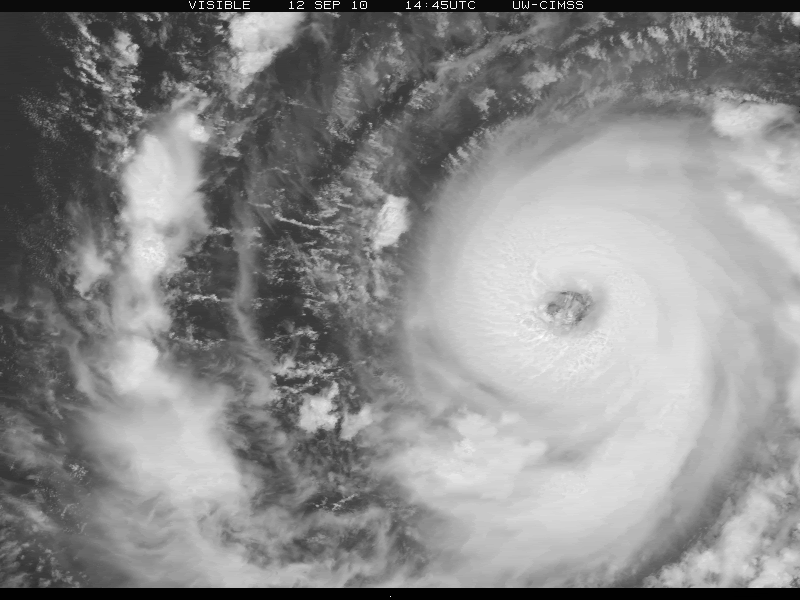
Igor looks amazing in that loop, thanks for posting it, you can really see the eye really clearly!
No doubt this is about 130kts IMO...
No doubt this is about 130kts IMO...
0 likes
Personal Forecast Disclaimer:
The posts in this forum are NOT official forecast and should not be used as such. They are just the opinion of the poster and may or may not be backed by sound meteorological data. They are NOT endorsed by any professional institution or storm2k.org. For official information, please refer to the NHC and NWS products
The posts in this forum are NOT official forecast and should not be used as such. They are just the opinion of the poster and may or may not be backed by sound meteorological data. They are NOT endorsed by any professional institution or storm2k.org. For official information, please refer to the NHC and NWS products
-
brunota2003

- S2K Supporter
- Posts: 9476
- Age: 35
- Joined: Sat Jul 30, 2005 9:56 pm
- Location: Stanton, KY...formerly Havelock, NC
- Contact:
-
JonathanBelles
- Professional-Met
- Posts: 11430
- Age: 35
- Joined: Sat Dec 24, 2005 9:00 pm
- Location: School: Florida State University (Tallahassee, FL) Home: St. Petersburg, Florida
- Contact:
Re: ATL: Hurricane IGOR - Discussion
With the latest microwave imagery, there is no sign of any EWRC coming, and based on that alone I do think this has a pretty good shot at becoming a Category 5 hurricane. T values have been steadily increasing, and if this rate continues there could be a T7.0 rating coming in the next 6-12 hours. After this time I would expect some deceleration to the rate of intensification. If there was any use for the Hurricane Drones, this would be the perfect opportunity since recon can't get out there. Perfect conditions may lead to a perfect storm (without landfall in the short term).
The A word has been mentioned, so I will quietly use it here. Igor has never had any really large feeder bands. I haven't been able to see the Annular percentages, but I would be close to saying the annular flag should be up soon, if not already.
The A word has been mentioned, so I will quietly use it here. Igor has never had any really large feeder bands. I haven't been able to see the Annular percentages, but I would be close to saying the annular flag should be up soon, if not already.
Code: Select all
The posts in this forum are NOT official forecast and should not be used as such. They are just the opinion of the poster and may or may not be backed by sound meteorological data. They are NOT endorsed by any professional institution or storm2k.org. For official information, please refer to the NHC and NWS products
0 likes

Whilst it may just be the Microwave imagery, the NE section doesn't look quite as perfect as it did a little while ago...but as I said that may just be the image.
Still a formidable hurricane, wonder how high the NHC will go next time round!
Still a formidable hurricane, wonder how high the NHC will go next time round!
0 likes
Personal Forecast Disclaimer:
The posts in this forum are NOT official forecast and should not be used as such. They are just the opinion of the poster and may or may not be backed by sound meteorological data. They are NOT endorsed by any professional institution or storm2k.org. For official information, please refer to the NHC and NWS products
The posts in this forum are NOT official forecast and should not be used as such. They are just the opinion of the poster and may or may not be backed by sound meteorological data. They are NOT endorsed by any professional institution or storm2k.org. For official information, please refer to the NHC and NWS products
-
neospaceblue

- Tropical Storm

- Posts: 112
- Age: 32
- Joined: Fri Aug 10, 2007 3:17 pm
- Location: Newport News, VA
Re:
Cainer wrote:If Igor becomes a Cat 5 before reaching 49.8 W, it'll be the easternmost forming Cat 5 on record, beating Cleo of '58.
I doubt it. It's approaching 47 W right now, so unless the NHC decides to upgrade at or before 11 PM, Cleo will still hold the record.
0 likes
-
alan1961

- Category 2
- Posts: 771
- Joined: Mon Mar 20, 2006 11:58 am
- Location: Derby, Derbyshire, England
- Contact:
Re: ATL: Hurricane IGOR - Discussion
Zooming in on Igor's eye he appeared to have a monsters face
to go with is strength

to go with is strength

0 likes
-
ozonepete
- Professional-Met
- Posts: 4743
- Joined: Mon Sep 07, 2009 3:23 pm
- Location: From Ozone Park, NYC / Now in Brooklyn, NY
Re: ATL: Hurricane IGOR - Discussion
Since we're discussing cat 5 possibilities and there are similarities, I thought this great CIMSS satellite history of Isabel would be interesting to look at...
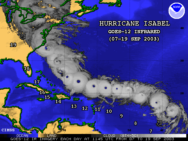
BTW it was cat 5 on the 11th and 12th
BTW it was cat 5 on the 11th and 12th
Last edited by ozonepete on Sun Sep 12, 2010 6:01 pm, edited 1 time in total.
0 likes
Who is online
Users browsing this forum: No registered users and 65 guests