ATL: IGOR - Ex Hurricane - Discussion
Moderator: S2k Moderators
-
Just Joshing You

- Category 2

- Posts: 512
- Joined: Sat Nov 03, 2007 10:29 am
- Location: Nova Scotia
Re: ATL: Hurricane IGOR - Discussion
The last image shows a pentagram inside Igors eye. Where can I find a 1km sat view?
0 likes
Re: ATL: Hurricane IGOR - Discussion
12z euro ....major shift W
144 hr position 34.5/ 69.5.....then out to sea hour 168
noses north central atlantic high SW late thur nite out ahead of igor....and keeps it there for a couple days
144 hr position 34.5/ 69.5.....then out to sea hour 168
noses north central atlantic high SW late thur nite out ahead of igor....and keeps it there for a couple days
0 likes
-
brunota2003

- S2K Supporter

- Posts: 9476
- Age: 35
- Joined: Sat Jul 30, 2005 9:56 pm
- Location: Stanton, KY...formerly Havelock, NC
- Contact:
-
dixiebreeze

- S2K Supporter
- Posts: 5140
- Joined: Wed Sep 03, 2003 5:07 pm
- Location: crystal river, fla.
Re: ATL: Hurricane IGOR - Discussion
canes04 wrote:If Igor continues at this pace he may get trapped by Friday.
Needs to pickup speed to catch the weakness.
From IR views the trough doesn't look all that strong.
0 likes
-
plasticup
Re: ATL: Hurricane IGOR - Discussion
Just Joshing You wrote:The last image shows a pentagram inside Igors eye. Where can I find a 1km sat view?
I thought that I had seen real-time high-res images from GOES-15, but I can't find the link...
0 likes
-
brunota2003
- S2K Supporter
- Posts: 9476
- Age: 35
- Joined: Sat Jul 30, 2005 9:56 pm
- Location: Stanton, KY...formerly Havelock, NC
- Contact:
-
cycloneye
- Admin

- Posts: 149478
- Age: 69
- Joined: Thu Oct 10, 2002 10:54 am
- Location: San Juan, Puerto Rico
Re: ATL: Hurricane IGOR - Discussion
18z Best Track
AL, 11, 2010091418, , BEST, 0, 187N, 527W, 125, 933, HU
Up to 125 kts.
AL, 11, 2010091418, , BEST, 0, 187N, 527W, 125, 933, HU
Up to 125 kts.
0 likes
Visit the Caribbean-Central America Weather Thread where you can find at first post web cams,radars
and observations from Caribbean basin members Click Here
and observations from Caribbean basin members Click Here
-
x-y-no

- Category 5

- Posts: 8359
- Age: 65
- Joined: Wed Aug 11, 2004 12:14 pm
- Location: Fort Lauderdale, FL
Re: ATL: Hurricane IGOR - Discussion
Just Joshing You wrote:The last image shows a pentagram inside Igors eye. Where can I find a 1km sat view?
There's NASA GHCC: http://www.ghcc.msfc.nasa.gov/GOES/
0 likes
-
plasticup
Re: ATL: Hurricane IGOR - Discussion
x-y-no wrote:Just Joshing You wrote:The last image shows a pentagram inside Igors eye. Where can I find a 1km sat view?
There's NASA GHCC: http://www.ghcc.msfc.nasa.gov/GOES/
This is the best that I could grab from that site:

edit: Playing with the custom animation feature you can see a lot of detail in the eye and the eyewall.
0 likes
-
leaf blower

- Tropical Low

- Posts: 39
- Joined: Mon Jul 21, 2008 8:01 am
-
JonathanBelles
- Professional-Met

- Posts: 11430
- Age: 35
- Joined: Sat Dec 24, 2005 9:00 pm
- Location: School: Florida State University (Tallahassee, FL) Home: St. Petersburg, Florida
- Contact:
Re: Re:
Wthrman13 wrote:fact789 wrote:hmm....Usually vorticies are seen in intensifying systems and in Cat 5's.
Not necessarily, at least not that I've heard. Sure, you usually see them in more intense hurricanes, but I'm not aware of any dynamical dependence on strengthening or on reaching Cat 5 status for them to appear; they have more to do with the internal dynamics of vortices (the ratio of inflow wind to rotational wind -- something known as the swirl ratio) than on the strength of the vortex. It just so happens with hurricanes that they tend to be most obvious in strong hurricanes, but I wouldn't be surprised if they showed up to some extent in lesser storms as well.
Interesting. I try to watch for warning signs (ERC, intensification, decreases in intensification), and just about every time there has been a quickly intensifying system Cat 2 or 3+, it has these vorts. As we have seen in the last few hours, intensification has occured.
0 likes
-
hurricaneCW
- Category 5
- Posts: 1799
- Joined: Wed Mar 03, 2010 6:20 am
- Location: Toms River, NJ
Re: ATL: Hurricane IGOR - Discussion
I wonder if his very slow movement could have a huge implication in the track. The latest gfs has also shifted a bit further to the west. If the track ends up being 100 miles to the west of Bermuda, then that's pretty good because it would be right in between the east coast and Bermuda.
Igor has really ramped up once again, he could make another run at Cat 5 today. Also, the size has really expanded as well, I'll bet tropical storm force winds are well over 200 miles out now.
Igor has really ramped up once again, he could make another run at Cat 5 today. Also, the size has really expanded as well, I'll bet tropical storm force winds are well over 200 miles out now.
0 likes
-
aerology
- Tropical Depression

- Posts: 56
- Age: 78
- Joined: Sun Oct 18, 2009 2:38 am
- Location: Concordia, Kansas
- Contact:
Every 25 hours these tropical storms have a surge of growth as the moon passes overhead, with a more general increase in size 12.5 hours either side when the secondary bulge in the atmosphere passes through their area, this and the angle the moon and sun are off from directly overhead gives us all of the wobbles to watch.
0 likes

Re: ATL: Hurricane IGOR - Discussion
Weatherfreak000 wrote:gotoman38 wrote:Igor seen from Aqua satellite on polar orbit - Monday afternoon
:: image ::
Any wallpaper sized pictures of Igor from space?
Here's the link
http://earthobservatory.nasa.gov/Natura ... p?id=45770
0 likes
-
WeatherLovingDoc

- S2K Supporter
- Posts: 453
- Joined: Fri Sep 05, 2008 10:08 pm
- Location: Washington D.C.
Re: ATL: Hurricane IGOR - Discussion
Great view. Thoughts anyone?
http://www.atmos.washington.edu/~ovens/loops/wxloop.cgi?wv_east_enhanced
http://www.atmos.washington.edu/~ovens/loops/wxloop.cgi?wv_east_enhanced
0 likes
Re: ATL: Hurricane IGOR - Discussion
gotoman38 wrote:Weatherfreak000 wrote:gotoman38 wrote:Igor seen from Aqua satellite on polar orbit - Monday afternoon
:: image ::
Any wallpaper sized pictures of Igor from space?
Here's the link
http://earthobservatory.nasa.gov/Natura ... p?id=45770
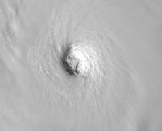
Igor's eye from this 8MB image

Last edited by gotoman38 on Tue Sep 14, 2010 3:20 pm, edited 1 time in total.
0 likes
-
Aric Dunn
- Category 5
- Posts: 21238
- Age: 43
- Joined: Sun Sep 19, 2004 9:58 pm
- Location: Ready for the Chase.
- Contact:
Look at that eye contract... either there it is intensifying more or the inner eyewall is contracting while and outer eyewall might be forming.. need some new microwave images.. and its wobbling back more westerly..
0 likes
Note: If I make a post that is brief. Please refer back to previous posts for the analysis or reasoning. I do not re-write/qoute what my initial post said each time.
If there is nothing before... then just ask
Space & Atmospheric Physicist, Embry-Riddle Aeronautical University,
I believe the sky is falling...
If there is nothing before... then just ask
Space & Atmospheric Physicist, Embry-Riddle Aeronautical University,
I believe the sky is falling...
Re: ATL: Hurricane IGOR - Discussion
wobble wobble
http://rammb.cira.colostate.edu/ramsdis ... _floater_1
thru 415pm.......i bet that the next move is NW....looks like stair stepping?
http://rammb.cira.colostate.edu/ramsdis ... _floater_1
thru 415pm.......i bet that the next move is NW....looks like stair stepping?
0 likes
Who is online
Users browsing this forum: No registered users and 50 guests