http://www.ssd.noaa.gov/goes/flt/t1/flash-wv.html
ATL: IGOR - Ex Hurricane - Discussion
Moderator: S2k Moderators
-
Tstormwatcher

- S2K Supporter

- Posts: 3086
- Joined: Thu Oct 20, 2005 7:31 pm
- Location: New Bern, NC
Re: ATL: IGOR - Hurricane - Discussion
Wow, check out this loop. He goes from NW to W to SW. 
http://www.ssd.noaa.gov/goes/flt/t1/flash-wv.html
http://www.ssd.noaa.gov/goes/flt/t1/flash-wv.html
0 likes
-
HURAKAN

- Professional-Met

- Posts: 46084
- Age: 39
- Joined: Thu May 20, 2004 4:34 pm
- Location: Key West, FL
- Contact:
Re: ATL: IGOR - Hurricane - Discussion
Tstormwatcher wrote:Wow, check out this loop. He goes from NW to W to SW.
http://www.ssd.noaa.gov/goes/flt/t1/flash-wv.html
That's the inner eye dancing inside the bigger eyewall
0 likes
-
brunota2003

- S2K Supporter
- Posts: 9476
- Age: 35
- Joined: Sat Jul 30, 2005 9:56 pm
- Location: Stanton, KY...formerly Havelock, NC
- Contact:
Hm...I've seen this before, and I think more study needs to be done. I remember Wilma went into an ERC, and the 2 mile wide eye was almost completely gone...then it refired back up and closed off again and basically reversed the ERC...now, the outer eyewall did win in the end, but still...it looks like Igor is doing similar, and the inner eyewall looks like it is actually tapping the energy from the outer one.
0 likes
-
O Town
- S2K Supporter
- Posts: 5205
- Age: 52
- Joined: Wed Sep 07, 2005 9:37 pm
- Location: Orlando, Florida 28°35'35"N 81°22'55"W
Wow, haven't looked at Igor all day....or since this morning. That eye has gotten really small, or hes gotten really big. Or I think its a bit of both, hes definitely a different looking storm than this morning. Looking a bit like Wilma, I hope he gets pulled off his course some or weakens a lot by Sunday because its not looking good for Bermuda.

0 likes
#ORLANDOSTRONG
-
hurricaneCW
- Category 5

- Posts: 1799
- Joined: Wed Mar 03, 2010 6:20 am
- Location: Toms River, NJ
Re: ATL: IGOR - Hurricane - Discussion
Bermuda has no chance of avoiding some of Igor's effects, Igor is far too massive for them to avoid him. It'll be interesting to see if Igor develops a huge eye once the EWRC is complete. It seems like everyday Igor transforms into a different storm with regards to its eye size, the intensity, and its size.
0 likes
-
wxman57

- Moderator-Pro Met

- Posts: 23174
- Age: 68
- Joined: Sat Jun 21, 2003 8:06 pm
- Location: Houston, TX (southwest)
Re: ATL: IGOR - Hurricane - Discussion
Igor really does appear to be expanding in size significantly. Microwave loop indicates a nearly complete ERC. Much larger RMW now:
http://cimss.ssec.wisc.edu/tropic/real- ... npage.html
http://cimss.ssec.wisc.edu/tropic/real- ... npage.html
0 likes
-
cycloneye

- Admin

- Posts: 149475
- Age: 69
- Joined: Thu Oct 10, 2002 10:54 am
- Location: San Juan, Puerto Rico
Re: ATL: IGOR - Hurricane - Discussion
00z Best Track
AL, 11, 2010091600, , BEST, 0, 200N, 561W, 115, 942, HU
AL, 11, 2010091600, , BEST, 0, 200N, 561W, 115, 942, HU
0 likes
Visit the Caribbean-Central America Weather Thread where you can find at first post web cams,radars
and observations from Caribbean basin members Click Here
and observations from Caribbean basin members Click Here
-
plasticup
I plan to watch this weather buoy: http://www.ndbc.noaa.gov/station_page.php?station=41044
The closest point of approach should be within 10 miles in about 26 hours. If that is near peak intensity it could provide the hard data that the NHC likes to have befor a Cat 5 classification.
The closest point of approach should be within 10 miles in about 26 hours. If that is near peak intensity it could provide the hard data that the NHC likes to have befor a Cat 5 classification.
0 likes
-
brunota2003
- S2K Supporter
- Posts: 9476
- Age: 35
- Joined: Sat Jul 30, 2005 9:56 pm
- Location: Stanton, KY...formerly Havelock, NC
- Contact:
-
HURAKAN
- Professional-Met
- Posts: 46084
- Age: 39
- Joined: Thu May 20, 2004 4:34 pm
- Location: Key West, FL
- Contact:
Re: ATL: IGOR - Hurricane - Discussion
Appears to be collapsing into the much larger eyewall. We should see a much larger eye in the next few hours clear up.
0 likes
-
plasticup
Re: ATL: IGOR - Hurricane - Discussion
I still see a tiny eye.

edit: next frame and it's gone
edit: next frame and it's gone
Last edited by plasticup on Wed Sep 15, 2010 8:29 pm, edited 2 times in total.
0 likes
-
dixiebreeze
- S2K Supporter
- Posts: 5140
- Joined: Wed Sep 03, 2003 5:07 pm
- Location: crystal river, fla.
Re: ATL: IGOR - Hurricane - Discussion
Igor doesn't seem very keen on getting north of 20.
http://www.ssd.noaa.gov/goes/flt/t1/flash-avn.html
http://www.ssd.noaa.gov/goes/flt/t1/flash-avn.html
0 likes
Re: ATL: IGOR - Hurricane - Discussion
dixiebreeze wrote:Igor doesn't seem very keen on getting north of 20.
http://www.ssd.noaa.gov/goes/flt/t1/flash-avn.html
nope he's a character....and he's about to display a 50 mile wide eye....
i also think he's being effected by upwelling right now
0 likes
Re: ATL: IGOR - Hurricane - Discussion
looks like something is plucking white cirrus "hairs" from the NW part of igor's "head"...
.looks like some Southerly shear will be impacting our friend soon....unless that 2'nd trough lifts out and flattens fairly soon.
http://rammb.cira.colostate.edu/ramsdis ... _floater_1
i wonder if igor may not be doing so well by morning
.looks like some Southerly shear will be impacting our friend soon....unless that 2'nd trough lifts out and flattens fairly soon.
http://rammb.cira.colostate.edu/ramsdis ... _floater_1
i wonder if igor may not be doing so well by morning
0 likes
-
ozonepete
- Professional-Met
- Posts: 4743
- Joined: Mon Sep 07, 2009 3:23 pm
- Location: From Ozone Park, NYC / Now in Brooklyn, NY
Re: ATL: IGOR - Hurricane - Discussion
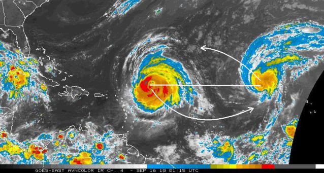
I’m surprised that the subject of Fujiwhara effect has not come up at the NHC yet. The centers of the two systems are about 1,000 miles apart now, and given the fact that Igor is moving WNW at 8mph and Julia is moving NW at 17 mph, they can very likely come within the distance of 900 miles where this effect can become reality.
The expected result from this interaction, EXCLUDING EXTERNAL STEERING, would be for Julia to move more to the west-northwest and Igor to move south or southeast. When you add in the ENVIRONMENTAL STEERING CURRENTS, you would expect Julia to move more westerly than forecast and Igor to become stationary or erratic in motion.
This is all predicated on the fact that Igor continues moving very slowly and Julia keeps moving at least twice as fast as Igor and also, very importantly, that Julia remains a fairly strong hurricane with a wind-field that remains as large or becomes even larger than it is now.
The annotated image I posted is of the TENDENCY caused by Fujiwhara. The net effect, as I said, would be for Igor to stall or move erratically.
0 likes

Re: ATL: IGOR - Hurricane - Discussion
ozonepete wrote:I’m surprised that the subject of Fujiwhara effect has not come up at the NHC yet. The centers of the two systems are about 1,000 miles apart now, and given the fact that Igor is moving WNW at 8mph and Julia is moving NW at 17 mph, they can very likely come within the distance of 900 miles where this effect can become reality.
The expected result from this interaction, EXCLUDING EXTERNAL STEERING, would be for Julia to move more to the west-northwest and Igor to move south or southeast. When you add in the ENVIRONMENTAL STEERING CURRENTS, you would expect Julia to move more westerly than forecast and Igor to become stationary or erratic in motion.
This is all predicated on the fact that Igor continues moving very slowly and Julia keeps moving at least twice as fast as Igor and also, very importantly, that Julia remains a fairly strong hurricane with a wind-field that remains as large or becomes even larger than it is now.
The annotated image I posted is of the TENDENCY caused by Fujiwhara. The net effect, as I said, would be for Igor to stall or move erratically.
http://i189.photobucket.com/albums/z174 ... opanno.jpg
use this site to estimate the distance of them:
http://jan.ucc.nau.edu/~cvm/latlongdist.html
they seem to have distance of 1400 miles right now
0 likes
-
hurricaneCW
- Category 5
- Posts: 1799
- Joined: Wed Mar 03, 2010 6:20 am
- Location: Toms River, NJ
Re: ATL: IGOR - Hurricane - Discussion
Igor circulation and overall size remains much larger than the weakening Julia. While there might be some effects from the interaction, I don't expect Igor to do anything too erratic. I expect Julia to get sheared further and weaken, Igor will probably maintain his intensity and continue to expand. For a classic Fujiwhara effect to take place, the storms have to be nearly identical in their size and strength, otherwise the stronger, larger circulation disrupts the smaller, weaker circulation.
0 likes
Who is online
Users browsing this forum: No registered users and 58 guests